
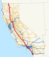
Interstate 5 in California
Encyclopedia
Interstate 5 is a major north–south route of the Interstate Highway System
in the U.S. state
of California
. It begins at the Mexico – United States border at the San Ysidro
crossing, goes north across the length of California and crosses into Oregon
south of the Medford
-Ashland
metropolitan area
.
This highway links the major California cities of San Diego, Santa Ana
, Los Angeles
, Stockton
, Sacramento
, and Redding
. Among the major cities not directly linked by Interstate 5 but are connected by local highways to the Interstate 5 are San Francisco, Oakland and San Jose
, which are about 80 miles (128.7 km) west of the highway.
and is eligible for the State Scenic Highway System
. However, it is a scenic highway as designated by Caltrans only from State Route 152 (SR 152) to I-580.
 Interstate 5 begins at the San Ysidro Port of Entry from Mexico in the San Ysidro neighborhood of San Diego. Immediately after the border, I-805 splits off to the northeast and serves as a bypass of I-5 that avoids the downtown San Diego area. I-5 itself continues northwest and intersects with the western end of the SR 905
freeway, a route that connects with the Otay Mesa border crossing
. I-5 then continues northward and joins the southern end of SR 75, a highway connecting to Coronado
via the Silver Strand
. I-5 then enters Chula Vista
, briefly leaving the San Diego city limits. It continues along the east side of San Diego Bay
where it intersects with SR 54 and enters National City
. From there, I-5 veers around the San Diego Naval Base and reenters the city limits of San Diego. I-5 subsequently interchanges with four state routes — SR 15 (the southern end of the extension of I-15), SR 75 and the Coronado Bay Bridge, the western end of SR 94, and the southern end of SR 163. In addition to serving downtown San Diego, I-5 also provides access to Balboa Park from the Pershing Drive exit.
After leaving downtown, I-5 continues northwest until it reaches its junction with I-8, then turns slightly to the north while passing near SeaWorld
and Mission Bay. Thereafter, I-5 interchanges with the western end of SR 52 before passing through the UC San Diego
campus in University City
near La Jolla
. Shortly afterward, I-5 interchanges with the northern terminus of I-805 before continuing north and interchanging with the western end of SR 56
. At this interchange, there is a recently-completed local bypass that provides the only access to Carmel Mountain Road from both directions and provides the only access to SR 56 going northbound.
North of the San Diego city limits, I-5 enters into the city limits of Solana Beach
, and then three incorporated cities to the north — Encinitas
, Carlsbad
and Oceanside
. In Oceanside, I-5 intersects with the SR 78 freeway and the SR 76 expressway and continues through the Camp Pendleton
. Toward the northern end of its routing through Camp Pendleton, I-5 passes through San Onofre State Beach and near the San Onofre Nuclear Generating Station
, as well as the proposed interchange with SR 241
near Trestles as a result from the possible Foothill Toll Road extension. It then follows the Pacific Ocean
coastline for the next 20 miles (32.2 km). I-5 enters Orange County
at the Christianitos Road exit.
, I-5 goes through San Clemente
. Then at Dana Point
, I-5 turns inland while SR 1, the Pacific Coast Highway, continues along the coast. I-5 then heads due north through San Juan Capistrano
and Mission Viejo
, interchanging with the SR 73 toll road
heading northwest. I-5 continues to the El Toro Y
interchange in southeastern Irvine
, splitting into lanes for regular traffic as well as for truck traffic (though autos can use these lanes as well). From that point, I-405
takes over the San Diego Freeway designation, while I-5 becomes the Santa Ana Freeway
as it runs southeast to northwest.
After the El Toro Y junction, I-5 intersects SR 133, a toll road that eventually connects to SR 91. Just before the Tustin
city limits, I-5 passes over SR 261, the final toll road of the Eastern Transportation Corridor,
but traffic must use Jamboree Road
to access the latter. I-5 then intersects with SR 55 and enters Santa Ana
, the county seat of Orange County. Towards the northern side of Santa Ana, I-5 intersects both SR 57 and SR 22 in what is known as the Orange Crush interchange
. Following this, I-5 briefly enters the city of Orange
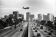
traverses Anaheim
and passes right next to Disneyland. I-5 then interchanges with SR 91, passes through Buena Park
and crosses into Los Angeles County
.
, Santa Fe Springs
and Norwalk
. The area between the Orange-Los Angeles County Line and Interstate 605 will be widened starting November 2011 through December 2016 to combine with the recent OC-LA County Line to CA-91 upgrade completed in November 2010.
In Downey
, I-5 intersects with I-605, which serves as a north to south connector route in the cities east of Los Angeles. I-5 then passes through Commerce
and intersects I-710 before entering the unincorporated area of East Los Angeles
, and later the city proper of Los Angeles
. When the freeway reaches the East Los Angeles Interchange
one mile (1.6 km) east of downtown Los Angeles, I-5 becomes the Golden State Freeway as US 101
takes over the Santa Ana Freeway designation. At this interchange, I-10, SR 60, and US 101 intersect; I-10 continues for a few miles north on I-5 before continuing east towards San Bernardino
and points further east.
On the north side of downtown, I-5 follows the Los Angeles River
, intersects with SR 110 and SR 2 and passes along the eastern side of Griffith Park
. The route continues through the San Fernando Valley
, interchanging with SR 134. It briefly enters the city of Glendale
and then Burbank
. I-5 passes near Burbank Airport before reentering the city limits of Los Angeles and intersecting the northern end of SR 170. Near the city of San Fernando
, I-5 intersects SR 118. Following this, I-5 intersects three routes in succession: the northern end of I-405, the western end of I-210 and the southern end of SR 14 at the Newhall Pass interchange
. It then crosses the Newhall Pass through the Santa Susana Mountains
into the Santa Clarita Valley
.
I-5 continues along the western city limits of Santa Clarita
and passes near Six Flags Magic Mountain
, intersecting SR 126 just north of there. The Golden State Freeway then sharply rises to the north, passing by Lake Castaic and Pyramid Lake (California)
and intersecting SR 138 to eventually cross the Tejon Pass
through the Tehachapi Mountains
with Path 26
power lines
generally paralleling the freeway. After entering Kern County
, the freeway then sharply descends for 12 miles (19 km) from over 4,100 feet (1,250 m) at the Tejon Pass to around 1,600 feet (488 m) at Grapevine
near the southernmost point of the San Joaquin Valley
, approximately 30 miles (50 km) south of Bakersfield
and 4 miles (6 km) south from where State Route 99 splits away from it in Wheeler Ridge
.
 From SR 99
to south of Tracy
, I-5 is known as the West Side Freeway. It parallels SR 33
, skirting along the far more remote western edge of the great Central Valley, and thus here is removed from population centers such as Bakersfield
, Fresno
and Modesto
, with other state highways providing connections. For most of this section, the Path 15
electrical transmission corridor follows the highway, forming an infrastructure corridor along with the California Aqueduct
.
North of the Grapevine, I-5 intersects SR 166, SR 119 and SR 43 before meeting SR 58, a highway that continues east to Bakersfield, near the town of Buttonwillow
. I-5 then interchanges with SR 46 before entering Kings County
. In Kings County, I-5 intersects SR 41 before briefly entering the city limits of Avenal
, where it intersects SR 269. In Fresno County
, I-5 intersects SR 198 and SR 145 before running concurrently
with SR 33 for several miles. I-5 then crosses into Merced County
, intersecting SR 165, SR 152 near the San Luis Reservoir
, SR 33, and SR 140 at the Stanislaus
county line.
In San Joaquin County
, Interstate 580
splits off from I-5 at a point south of Tracy, providing a spur-route connection to the San Francisco Bay Area
, with SR 152 the other major connection to the South Bay of the Bay Area. From here, I-5 intersects SR 132, a major route east to the mountains, as well as the northern end of SR 33. After passing Tracy, I-5 intersects I-205, a connector route to I-580, before intersecting the SR 120 freeway in the Manteca
city limits. After passing through Lathrop
, I-5 heads due north through Stockton
, interchanging with the SR 4 freeway that provides access to downtown Stockton. I-5 passes through the western portion of the Lodi
city limits before intersecting SR 12 and entering Sacramento County
.
I-5 enters the city of Elk Grove
while passing along the eastern edge of the Stone Lakes National Wildlife Refuge
. It then crosses into the Sacramento
city limits, soon paralleling the Sacramento River
before intersecting the Capital City Freeway, which carries US 50 and Interstate 80 Business
. SR 99 merges with I-5 at this point, and the two routes pass through the western half of downtown Sacramento. Following the bridge over the American River
, I-5 and SR 99 intersect the major transcontinental route of I-80. Just as I-5 leaves Sacramento, SR 99 splits off and continues north while I-5 turns due west past Sacramento International Airport
and crosses the Sacramento River into Yolo County
. In Woodland
, the SR 113 freeway merges with I-5 before exiting to the north. The interstate heads northwest again toward Dunnigan
, where it converges with Interstate 505.
I-5 skirts north along the western edge of the Sacramento Valley
, bypassing the larger cities of the region, including Yuba City
, Oroville
and Chico
, before reaching Red Bluff
. From Dunnigan, I-5 enters Colusa County
, passing through the city of Williams
and intersecting SR 20. In Glenn County
, I-5 intersects SR 162 in Willows
and SR 32 in Orland
. I-5 then crosses into Tehama County
, passing through Corning
before entering Red Bluff and intersecting SR 36, which connects to the northern end of SR 99. I-5 crosses the Sacramento River twice before entering Shasta County
.
 I-5 then enters the Shasta Cascade
region, intersecting SR 273 in Anderson
before passing through Redding
and intersecting SR 44 and SR 299. The freeway then continues through the city of Shasta Lake
, intersecting SR 151, before crossing over Shasta Lake
on a causeway
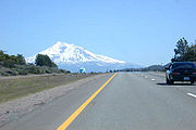
and climbing up to near the foot of Mount Shasta
. In Siskiyou County
, I-5 passes through Dunsmuir
before intersecting SR 89 near Lake Siskiyou
and entering the city of Mount Shasta
. North of here, US 97 intersects with I-5 in Weed
, providing access to Klamath Falls, Oregon
. The interstate then continues to Yreka
, intersecting SR 3 and SR 96 before crossing the Klamath River
and reaching Siskiyou Pass
and the Oregon border.
to San Diego was also co-signed as U.S. Route 101 until late 1964. The portion of this highway from Woodland
to Red Bluff
roughly follows old US 99W.
In California, the former western branch of Interstate 5 (the northern end of the spur into the Bay Area
) connecting Interstate 80 out of Vacaville
to near Dunnigan
, previously known as Interstate 5W, was renamed Interstate 505. Interstate 580 running between I-5 and I-80 was also once designated 5W; what is now I-5 (the stretch that runs through Sacramento) had been originally designated Interstate 5E.
in 1953. The proposal drew strong criticism from East Los Angeles
residents as it would dissect and eliminate large residential and commercial areas of Boyle Heights and Hollenbeck Heights. The proposal also seemed to indicate a disregard for the ethnic Mexican American
population of metropolitan Los Angeles. The "Boyle-Hollenbeck Anti-Golden State Freeway Committee" was formed for the purpose in blocking or rerouting the freeway. Then-Los Angeles City Council
member Edward R. Roybal
chaired that committee. Despite this opposition, the construction of the freeway went ahead.
When this section was completed in 1956, the newspaper The Eastside Sun wrote the freeway led to the "eradication, obliteration, razing, moving, ripping asunder, demolishing of Eastside homes."
, Antelope Valley Freeway). In 1862, Beale Cut was made in the construction of a toll wagon road. The 15’ wide, 60’ deep “slot” was dug with picks and shovels. That road would become part of the Midway Route. At the turn of the century, it was the most direct automobile route between Los Angeles and the San Joaquin Valley via the Mojave Desert and Tehachapi Pass.
In 1910, Beale Cut was bypassed by the Newhall tunnel. Constructed by Los Angeles County, it was too narrow for two trucks to pass each other inside. As a result, in 1939, the tunnel was completely removed (or “daylighted”) when the road was widened to four lanes. By 1930, a bypass road was constructed to avoid Newhall Pass via Weldon and Gavin canyons, which is the current route of I-5.
Interestingly, both routes were eventually built as freeways. The Gavin Canyon route became I-5, and the main north-south route via the Ridge Route. The Newhall Pass route became SR 14
(Antelope Valley Freeway), which is the main route between Los Angeles and the growing high desert communities. It is also still a part of the important Midway Route, which is the primary alternate route when I-5 is closed (via SR 58
and SR 14
).
In the evening of October 12, 2007, two trucks collided in the southbound tunnel that takes the truck bypass
roadway under the main lanes near the Newhall Pass interchange
. Fifteen trucks caught fire, killing three people and injuring 10.
, through the Tejon Pass
. The highway had its origins in the early 1910s, when a route was needed to connect Los Angeles to the Central Valley. Some believed that the only option was the route through Mojave and the Tehachapi Mountains, but a new route was discovered through the Tejon Pass. This route became known as the Ridge Route and saw almost constant planning and construction from 1914 to 1970.
The first road was completed in 1915. It was a slow, winding, two-lane road through the mountains with a speed limit of 15 mph in some places. However, the need for improvements was realized soon after it was completed. The road was paved after World War I
, and several blind turns were opened up ("daylighted"). Even with these improvements in the 1920s, it became clear that a new route was needed to keep up with increasing demand.
In 1927, plans were drawn up for a "Ridge Route Alternate," named as it was planned as an addition to the existing Ridge Route and not as a replacement. It opened in 1933 as a three-lane highway through the mountains. The middle or "suicide lane" was used as an overtaking lane for cars in both directions. This route was a great improvement, faster and 9.7 miles (15.6 km) shorter than the old Ridge Route, but was not enough to satisfy demand, and a conversion to a four-lane expressway was needed. The outbreak of World War II
delayed this until 1948 and the fourth lane was completed in 1952. However, just three years later, plans were begun for converting the four-lane expressway to a six-lane freeway.
The last major alteration to the Ridge Route began in the early 1960s. By then, the plan for a six-lane freeway had expanded to eight lanes. This construction project made the most changes to the route. Many of the curves that followed the mountainside were cut through. To climb the mountain on the south side of Castaic more easily, traffic lanes were reversed (southbound lanes to the east and northbound lanes to the west). To prevent head-on collisions, the two ends of the route were separated on two different mountainsides, and the section through Piru Canyon was moved to an entirely new alignment to make room for Pyramid Lake. The project was completed by 1970 and brought the Ridge Route to its current alignment.
was created in 1956, there was discussion about which way to route the interstate through the San Joaquin Valley (Central Valley). Two proposals were considered. One was to convert the Golden State Highway (U.S. Route 99, later CA Route 99) into a freeway. The other was to use the proposed West Side Freeway (current Interstate 5). The Golden State Highway route would serve many farming communities across the San Joaquin Valley, but the West Side Freeway proposal would bypass all the Central Valley communities and thus provide a faster and more direct north-south route through the state and so was eventually chosen.
Construction began in the early 1960s. There were just three phases for the 321 miles (516.6 km). The first phase, completed in 1967, ran from the San Joaquin County line to Los Banos. The second phase, completed in 1972, extended the freeway south to Wheeler Ridge and connected it to SR 99. The freeway then started to see traffic, as in Stockton there were only 4 miles (6.4 km) between the West Side Freeway and the Golden State Highway. The third phase, completed in 1979, extended the freeway to Sacramento and connected it to the northern I-5.
When the second phase of the freeway opened in 1972, it was a long and lonely route with no businesses alongside. Services were not easily available as the nearest towns were miles away and generally out of sight. It was common for cars to run out of fuel. Now, the West Side Freeway (I-5) is lined with farms and businesses serving the needs of travelers. For years, there has still been interest in designating the Golden State Highway route as its own interstate.
The median on I-5 between Wheeler Ridge and Tracy is wide enough to accommodate widening the West Side Freeway to six or eight lanes, should the need ever arise.
, Oakland
, and the rest of the San Francisco Bay Area
. Original plans also called for a loop Interstate with a directional suffix, I-5W. This route now roughly corresponds to I-580
from I-5 south of Tracy
to Oakland, I-80 from Oakland to Vacaville
, and I-505
from Vacaville to I-5 near Dunnigan
. I-5W and most of the other Interstates around the country with directional suffixes were eventually renumbered or eliminated, sans I-35E
and I-35W
in Texas and Minnesota. Nevertheless, San Francisco is still listed as a control city
on northbound I-5 between Highway 99 and I-580.
closely follows the Sacramento River
. This has resulted in complex engineering work to keep the section dry due to it being located below the water table. Locally, Caltrans refers to this part of the freeway as the “Boat Section.". Due to record levels of rainfall in 1980 the Boat Section was flooded with 15 ft (4.6 m) of water. Caltrans began constructing this section during the 1960s and 1970s. The freeway was engineered below grade so it would be out of the view of offices and shops in Downtown Sacramento. To achieve this, the site was excavated and the seeping water was pumped from the area. An intricate drainage system, water pump and retaining wall are used to protect the freeway from the Sacramento River
. In the early 2000s it was announced that sand and silt buildup over the years was blocking the original drainage system that protected I-5. Major repair work of the Boat Section in Sacramento
began on May 30, 2008. The construction was to take 40 days to complete, requiring complete northbound and southbound closures on an alternating schedule.
|rowspan=6|Oceanside
|R51.20
|51B
|
|Signed as exits 51B (SR 78) and 51C (Vista Way) northbound
|- style="background:#fdd;"
|R51.47
|51C
|Cassidy Street
|No northbound exit
|-
|R52.30
|52
|Oceanside Boulevard
|
|-
|R53.21
|53
|Mission Avenue (SR 76 Bus.) – Downtown Oceanside
|Serves Mission San Luis Rey
|-
|R53.93
|54A
|
|Signed as exits 54A (SR 76) and 54B (Coast Highway) southbound
|-
|R54.39
|54B
|Harbor Drive – Camp Pendleton
, Oceanside
|Signed as exits 54B (Camp Pendleton) and 54C (Harbor Drive) northbound
|-
|
|R62.08
|62
|Las Pulgas Road
|
|-
|
|R71.38
|71
|Basilone Road – San Onofre
|
|-
|
|R72.28
|72
|Cristianitos Road (I-5 Bus. north)
|
|-
|rowspan=58|Orange
ORA 0.00-44.38
|rowspan=6|San Clemente
|1.00
|73
|Avenida Magdalena, Avenida Calafia
|
|-
|1.63
|74
|El Camino Real
|
|- style="background:#fdd;"
|2.31
|75
|Avenida Presidio – San Clemente
|No southbound exit
|- style="background:#fdd;"
|2.66
|75
|Avenida Palizada – San Clemente
|Southbound exit and northbound entrance
|-
|3.39
|76
|Avenida Pico
|
|-
|4.08
|77
|Avenida Vista Hermosa
|
|-
|rowspan=2|Dana Point
|5.80
|78
|Camino de Estrella
|
|-
|6.78
|79
|
|Pacific Coast Highway was former US 101 Alt. north
|-
|rowspan=3|San Juan Capistrano
|8.80
|81
|Camino Capistrano
|
|-
|9.60
|82
|
|
|-
|10.91
|83
|Junipero Serra Road
|
|-
|rowspan=4|Mission Viejo
| style="background:#fdd;"|12.49
| style="background:#fdd;"|85A
| style="background:#fdd;"|
| style="background:#fdd;"|Northbound exit and southbound entrance
|-
|12.94
|85B
|Avery Parkway
|Signed as exit 85 southbound
|-
|13.78
|86
|Crown Valley Parkway
|
|-
|15.22
|88
|Oso Parkway
|
|-
|rowspan=4|Laguna Hills
|16.53
|89
|La Paz Road
|
|-
|17.47
|90
|Alicia Parkway
|
|-
|18.69
|91
|El Toro Road (CR S18)
|
|-
|19.89
|92A
|Lake Forest Drive
|Signed as exit 92 southbound
|-
|rowspan=9|Irvine
|20.84
|92B
|Bake Parkway
|Signed as exit 92 southbound
|-
|21.30
|94A
|
|Northbound exit and southbound entrance; former SR 7 north
|-
|22.21
|94B
|Alton Parkway
|Signed as exit 94 southbound
|- style="background:#fdd;"
|22.80
|
|Barranca Parkway
|Southbound exit and northbound entrance (HOV
only)
|- style="background:#fdd;"
|23.12
|95
|
|No access from I-5 north to SR 133 south; signed as exit 96B southbound
|-
|R23.94
|96
|Sand Canyon Avenue
|Signed as exit 96A southbound
|-
|R24.99
|97
|Jeffrey Road
|
|-
|R26.58
|99
|Culver Drive
|
|-
|rowspan=2|27.59
|rowspan=2|100
|rowspan=2|Jamboree Road
(to SR 261
)
|rowspan=2|
|-
|rowspan=5|Tustin
|-
|28.25
|101A
|Tustin Ranch Road
|
|-
|R29.09
|101B
|Red Hill Avenue – Tustin
|
|- style="background:#fdd;"
|29.62
|102
|Newport Avenue
|Southbound exit and northbound entrance
|- style="background:#fdd;"
|rowspan=2|30.26
|rowspan=2|103A
|rowspan=2|
|rowspan=2|Signed as exits 103A (north) and 103B (south) northbound; no access from I-5 south to SR 55 north
|-
|rowspan=5|Santa Ana
|-
|30.90-
31.09
|103C
|First Street, Fourth Street
|Signed as exit 104A southbound
|-
|31.76
|104
|Grand Avenue, Santa Ana Boulevard
|Signed as exit 104B southbound
|-
|32.46
|105A
|17th Street
|
|-
|33.09
|105B
|Main Street, Broadway – Santa Ana
|Main Street was SR 73
south; Broadway was former SR 51 north
|-
|rowspan=3|Santa Ana
,
Orange
|34.00
|106
|
|Signed as exits 107A (east) and 107B (west) southbound; northbound exit to SR 22 east is via exit 105B
|-
|34.14
|107A
|La Veta Avenue, Bristol Street
|Northbound exit is part of exit 106; serves Angel Stadium
|- style="background:#fdd;"
|34.27
|107A
|
|Northbound exit and southbound entrance
|-
|rowspan=3|Orange
|34.94
|107B
|Chapman Avenue
|Southbound exit is via exit 107C; former SR 51 south
|-
|35.19
|107C
|State College Boulevard, The City Drive
|State College Boulevard was former SR 250 north
|-
|rowspan=2|35.59
|rowspan=2|109A
|rowspan=2|Orangewood Avenue
|rowspan=2|Northbound exit is via exit 107C
|-
|rowspan=9|Anaheim
|-
|35.92
|
|Gene Autry Way, Disney Way
|HOV
only
|-
|36.26
|109A
|Katella Avenue
|Signed as exit 109 northbound
|-
|36.61
|109B
|Disney Way, Anaheim Boulevard
|Northbound exit is via exit 109; former SR 72
|-
|37.40
|110A
|Harbor Boulevard
|Signed as exit 110 northbound
|-
|37.64-
38.06
|110B
|Disneyland Drive, Ball Road
|Northbound exit is via exit 110
|-
|38.92
|111
|Lincoln Avenue
|Former SR 214
|-
|39.51
|112
|Euclid Street
|
|-
|40.71-
40.93
|113
|Brookhurst Street, La Palma Avenue
|Signed as exits 113A (Brookhurst Street, La Palma Avenue west) and 113B (La Palma Avenue east) northbound
|-
|rowspan=2|Anaheim
,
Fullerton
|41.50
|114
|Magnolia Avenue
|Signed as exit 114A southbound
|-
|42.10
|113C
|
|Signed as exit 114B southbound; northbound exit to SR 91 east is via exit 114; southbound exit to SR 91 west is via exit 114A
|-
|rowspan=3|Buena Park
| style="background:#fdd;"|43.13
| style="background:#fdd;"|115
| style="background:#fdd;"|Auto Center Drive
| style="background:#fdd;"|Northbound exit and entrance; former US 101 / SR 14
|-
|43.43
|116
|
|
|-
|44.26
|117
|Knott Avenue, Artesia Boulevard
|Former SR 91
|-
|rowspan=91|Los Angeles
LA 0.00-R88.61
|La Mirada
|rowspan=2|1.21
|rowspan=2|118
|rowspan=2|Valley View Avenue – La Mirada
|rowspan=2|
|-
|Santa Fe Springs
|-
|rowspan=2|Santa Fe Springs
,
Norwalk
|2.41
|119
|Carmenita Road
|
|-
|3.44
|120A
|Rosecrans Avenue – La Mirada
|Signed as exit 120 southbound
|-
|rowspan=3|Norwalk
| style="background:#fdd;"|3.64
| style="background:#fdd;"|120B
| style="background:#fdd;"|Firestone Boulevard
| style="background:#fdd;"|Northbound left exit and southbound entrance; former SR 42
|-
|4.41
|121
|Norwalk Boulevard, San Antonio Drive – Norwalk
|Former SR 35
|-
|4.91-
5.12
|122
|Imperial Highway
, Pioneer Boulevard
|
|-
|rowspan=2|Santa Fe Springs
,
Downey
|6.38
|123
|Florence Avenue
|
|-
|6.85
|124
|
|
|-
|rowspan=2|Downey
|8.31
|125
|
|
|-
|8.95
|126A
|Paramount Boulevard – Downey
|
|-
|rowspan=2|Montebello
,
Commerce
| style="background:#fdd;"|9.70
| style="background:#fdd;"|126B
| style="background:#fdd;"|Slauson Avenue
– Montebello
| style="background:#fdd;"|No northbound entrance
|-
|10.88
|128A
|Bandini Boulevard, Garfield Avenue
|
|-
|rowspan=6|Commerce
|11.55
|128B
|Washington Boulevard
– Commerce
|
|-
|12.80
|129
|Eastern Avenue, Atlantic Boulevard
|Former SR 15
|-
|12.92
|130A
|Atlantic Boulevard south, Triggs Street
|
|-
|13.78
|130B
|
|Northbound exit is via exit 130A
|- style="background:#fdd;"
|13.78
|130C
|
|Northbound exit and southbound entrance
|- style="background:#fdd;"
|13.89
|130B
|Eastern Avenue
|Northbound exit only
|-
|rowspan=2|East Los Angeles
| style="background:#fdd;"|14.25
| style="background:#fdd;"|131A
| style="background:#fdd;"|Olympic Boulevard
| style="background:#fdd;"|Southbound exit and northbound entrance; former SR 26 / SR 245
|-
|14.80
|131B
|Ditman Avenue, Indiana Street
|Signed as exit 131 southbound
|-
|rowspan=26|Los Angeles
|14.94
|132
|Indiana Street, Calzona Street
|
|- style="background:#fdd;"
|16.05
|133
|Euclid Avenue, Grande Vista Avenue
|Northbound exit and southbound entrance
|- style="background:#fdd;"
|16.47
|134B
|
|Southbound left exit and northbound entrance
|-
|16.59
|134B
|Soto Street
|Signed as exit 134A southbound
|- style="background:#fdd;"
|16.88
|
|
|Northbound left exit and southbound left entrance
|- style="background:#fdd;"
|16.90
|134C
|Seventh Street
|No southbound exit; left exit northbound
|- style="background:#dfd;"
|16.90
|134A
|
|South end of I-10 overlap; signed as exit 134C southbound
|-
|17.56
|135A
|Fourth Street
|Former SR 60
|-
|18.06
|135B
|Cesar Chavez Avenue
|
|- style="background:#dfd;"
|18.45
|135C
|
|North end of I-10 overlap; signed as exit 135B southbound
|- style="background:#fdd;"
|18.78
|135C
|Mission Road
|No northbound exit
|- style="background:#fdd;"
|19.20
|136A
|Main Street
|Signed as exit 136 southbound; no entrance ramps
|-
|19.73
|136B
|Broadway
|Southbound exit is part of exit 137A
|-
|20.44
|137B
|
|Signed as exit 137A southbound
|-
|
|137A
|Figueroa Street
|Southbound exit is part of exit 137B; former SR 159 / SR 163 north
|- style="background:#fdd;"
|
|137B
|
|Southbound exit and northbound entrance
|-
|21.94
|138
|Stadium Way
|
|-
|22.55
|139
|
|Signed as exits 139A (north) and 139B (south) northbound
|- style="background:#fdd;"
|22.97
|140A
|Fletcher Drive
|Southbound exit and northbound entrance; former SR 2
|-
|23.66
|140B
|Glendale Boulevard
|Signed as exit 140 northbound
|-
|24.33
|141A
|Los Feliz Boulevard
|Signed as exit 141 southbound
|- style="background:#fdd;"
|24.60
|141B
|Griffith Park
|Northbound exit and southbound entrance
|-
|25.78
|142
|Colorado Street – Glendale
|Former SR 134 east / SR 163 south
|- style="background:#fdd;"
|26.47
|144A
|Zoo Drive
|No southbound exit; serves Los Angeles Zoo
|-
|26.65
|144A
|
|Signed as exit 144 southbound
|- style="background:#fdd;"
|27.08
|144B
|
|Northbound exit and southbound entrance; southbound exit is via exit 145A
|-
|Glendale
|27.84
|145A
|Western Avenue
|
|-
|rowspan=6|Burbank
|28.43
|145B
|Alameda Avenue
|Former SR 134 west
|-
|29.16
|146A
|Olive Avenue, Verdugo Avenue – Burbank
|
|-
|29.78
|146B
|Burbank Boulevard
|
|- style="background:#fdd;"
|30.47
|147A
|Scott Road – Burbank
|Signed as exit 147 southbound; no southbound entrance
|- style="background:#fdd;"
|30.75
|147B
|Lincoln Street
|Northbound exit and southbound entrance
|-
|31.23
|148
|Buena Vista Street
|
|-
|rowspan=20|Los Angeles
|32.35
|149
|Hollywood Way
|
|- style="background:#fdd;"
|33.28
|150A
|Glenoaks Boulevard
|Northbound exit and southbound entrance
|-
|33.68
|150B
|Sunland Boulevard – Sun Valley
|Signed as exit 150 southbound
|- style="background:#fdd;"
|34.28
|151
|Penrose Street
|No northbound entrance
|-
|34.65-
34.99
|152
|Lankershim Boulevard
, Tuxford Street – North Hollywood
|Former SR 170
|-
|35.94
|153A
|Sheldon Street
|
|- style="background:#fdd;"
|36.36
|153B
|
|Southbound exit and northbound entrance
|- style="background:#fdd;"
|36.86
|153B
|Branford Street
|Northbound exit and southbound entrance
|-
|37.41
|154
|Osborne Street – Arleta
|
|- style="background:#fdd;"
|37.96
|155A
|Terra Bella Street
|Northbound exit and southbound entrance
|- style="background:#fdd;"
|38.50
|155B
|Van Nuys Boulevard – Pacoima
|Northbound exit and southbound entrance
|-
|39.05
|156A
|Paxton Street
|Signed as exit 156B northbound
|-
|39.36
|156B
|
|Signed as exit 156A northbound; southbound exit to SR 118 west is via exit 156A
|- style="background:#fdd;"
|39.98
|157A
|Brand Boulevard – San Fernando
|Northbound exit and southbound entrance; former SR 118
|-
|40.24
|157B
|San Fernando Mission Boulevard – San Fernando
|Signed as exit 157 southbound; former US 66
south / US 99 south
|- style="background:#fdd;"
|41.60
|158
|
|Southbound exit and northbound entrance; former SR 7 south
|-
|42.65
|159
|Roxford Street – Sylmar
|Signed as exits 159A (east) and 159B (west) northbound
|-
|R44.01
|161A
|
|Signed as exit 161B northbound
|- style="background:#fdd;"
|R44.87
|161B
|Balboa Boulevard
|Southbound exit and northbound entrance
|-
|R45.58
|162
|
|Former US 6
north
|-
|rowspan=7|Santa Clarita
|R49.03
|166
|Calgrove Boulevard
|
|-
|R50.33
|167
|Lyons Avenue, Pico Canyon Road
|
|-
|R51.44
|168
|McBean Parkway
|
|-
|R52.47
|169
|Valencia Boulevard
|
|-
|R53.57
|170
|Magic Mountain Parkway
|Former SR 126
east
|- style="background:#fdd;"
|R54.17
|171
|Rye Canyon Road
|Southbound exit and entrance
|-
|R55.48
|172
|
|
|-
|
|R56.60
|173
|Hasley Canyon Road – Wayside Honor Rancho
|
|-
|rowspan=2|Castaic
| style="background:#fdd;"|R59.01
| style="background:#fdd;"|176A
| style="background:#fdd;"|Parker Road – Castaic
| style="background:#fdd;"|Northbound exit and southbound entrance
|-
|R59.49
|176B
|Lake Hughes Road – Castaic Lake Park, Castaic
|Signed as exit 176 southbound
|-
|
|R65.97
|183
|Templin Highway
|
|-
|
|R74.45
|191
|Vista del Lago Road
|
|-
|
|R77.96
|195
|Smokey Bear Road
|
|-
|
|R81.49-
R82.10
|198A
|
|Signed as exit 199 southbound
|-
|
|R81.76
|198B
|Quail Lake Road
|Signed as exit 198 southbound
|-
|Gorman
|R85.80
|202
|Gorman
|
|-
|
|R88.57
|205
|Frazier Mountain Park Road
|
|-
|rowspan=18|Kern
KER R0.00-87.03
|Lebec
|1.61
|207
|Lebec
|
|-
|Fort Tejon
|5.02
|210
|Fort Tejon
|
|-
|Grapevine
|10.15
|215
|Grapevine
|
|-
|
|13.52
|219
|Laval Road
|Signed as exits 219A (east) and 219B (west)
|-
|
| style="background:#fdd;"|R15.86
| style="background:#fdd;"|221
| style="background:#fdd;"|
| style="background:#fdd;"|Northbound left exit and southbound left entrance; former US 99 north
|-
|
|19.61
|225
|
|
|-
|
|22.88
|228
|Copus Road
|
|-
|
|29.07
|234
|Old River Road
|
|-
|
|33.49
|239
|
|
|-
|
|38.79
|244
|
|Former US 399
|-
|
|41.19
|246
|
|
|-
|
|47.55
|253
|Stockdale Highway
|
|-
|
|52.15
|257
|
|
|-
|
| style="background:#fdd;"|56.64
| style="background:#fdd;"|262
| style="background:#fdd;"|7th Standard Road, Rowlee Road
| style="background:#fdd;"|Northbound exit and southbound entrance
|-
|
| style="background:#fdd;"|58.01
| style="background:#fdd;"|263
| style="background:#fdd;"|Buttonwillow
, McKittrick
| style="background:#fdd;"|Southbound exit and northbound entrance
|-
|
|62.61
|268
|Lerdo Highway – Shafter
|
|-
|Lost Hills
|73.02
|278
|
|Former US 466
|-
|
|82.35
|288
|Twisselman Road
|
|-
|rowspan=2|Kings
KIN 0.00-26.72
|
|12.36
|305
|Utica Avenue
|
|-
|
|16.60
|309
|
|
|-
|rowspan=11|Fresno
FRE 0.00-66.16
|
|0.23
|319
|
|
|-
|
|5.50
|325
|Jayne Avenue – Coalinga
|
|-
|
|14.87
|334
|
|
|-
|
| style="background:#dfd;"|17.96
| style="background:#dfd;"|337
| style="background:#dfd;"|
| style="background:#dfd;"|South end of SR 33 overlap
|-
|
| style="background:#dfd;"|29.96
| style="background:#dfd;"|349
| style="background:#dfd;"|
| style="background:#dfd;"|North end of SR 33 overlap
|-
|
|38.36
|357
|Kamm Avenue
|
|-
|
|45.80
|365
|Manning Avenue – San Joaquin
|
|-
|
|48.99
|368
|Panoche Road
|
|-
|
|52.75
|372
|Russell Avenue – Dos Palos
|
|-
|
|60.08
|379
|Shields Avenue (CR J1) – Mendota
|
|-
|
|65.78
|385
|Nees Avenue – Firebaugh
|
|-
|rowspan=4|Merced
MER 0.00-32.48
|
|6.28
|391
|
|
|-
|
|17.58
|403
|, San Jose
, Monterey
|Signed as exits 403A (south/east) and 403B (north/west)
|-
|Santa Nella
|21.84
|407
|
|
|-
|
|32.39
|418
|
|
|-
|rowspan=4|Stanislaus
STA 0.00-28.06
|
|5.51
|423
|Stuhr Road (CR J18) – Newman
|
|-
|
|10.72
|428
|Fink Road – Crows Landing
|
|-
|
|15.86
|434
|Diablo Grande Parkway, Sperry Avenue (CR J17) – Patterson
|
|-
|
|22.99
|441
|Howard Road (CR J16) – Westley
|
|-
|rowspan=29|San Joaquin
SJ 0.00-49.82
|
| style="background:#fdd;"|0.68
| style="background:#fdd;"|446
| style="background:#fdd;"|
| style="background:#fdd;"|Northbound left exit and southbound left entrance
|-
|
|3.44
|449
|
|Signed as exits 449A (east) and 449B (west)
|-
|
|6.47
|452
|
|Ahern Road was former SR 33 north
|-
|
|11.06
|457
|Kasson Road (CR J4)
|
|-
|
| style="background:#fdd;"|R11.80
| style="background:#fdd;"|458A
| style="background:#fdd;"|.svg.png) I-205 Bus. west (Eleventh Street) – Tracy
I-205 Bus. west (Eleventh Street) – Tracy
| style="background:#fdd;"|Southbound exit and northbound entrance; former US 50
west
|-
|
| style="background:#fdd;"|R12.62
| style="background:#fdd;"|458B
| style="background:#fdd;"|
| style="background:#fdd;"|Southbound exit and northbound entrance
|-
|rowspan=4|Lathrop
|R13.87
|460
|Mossdale Road, Manthey Road
|
|-
|R14.83
|461
|
|
|-
|R16.47
|462
|Louise Avenue
|
|-
|R17.52
|463
|Lathrop Road
|
|-
|
|R19.58
|465
|Roth Road – Sharpe Depot
|
|-
|
| style="background:#fdd;"|R20.95
| style="background:#fdd;"|467A
| style="background:#fdd;"|El Dorado Street
| style="background:#fdd;"|Northbound exit and southbound entrance; former US 50
east
|-
|
|R21.44
|467B
|Mathews Road
|Signed as exit 467 southbound
|-
|
|R22.51
|468
|French Camp Road (CR J9) – French Camp
|
|-
|rowspan=11|Stockton
|R23.66
|469
|Downing Avenue
|
|-
|24.64
|470
|Eighth Street
|
|- style="background:#dfd;"
|25.34
|471
|
|South end of SR 4 overlap; former SR 4 east
|- style="background:#dfd;"
|26.19
|472
|
|North end of SR 4 overlap
|-
|26.99
|473
|Pershing Avenue, Oak Street, Fremont Street
|
|-
|27.91
|474A
|Monte Diablo Avenue
|
|-
|28.53
|474B
|Country Club Boulevard, Alpine Avenue
|
|-
|29.99
|476
|March Lane
|
|-
|31.45
|477
|Benjamin Holt Drive
|
|-
|32.66
|478
|Hammer Lane
|
|-
|35.30
|481
|Eight Mile Road
|
|-
|
|39.57
|485
|
|
|-
|
|41.66
|487
|Turner Road
|
|-
|
|44.71
|490
|Peltier Road (CR J12)
|
|-
|
|47.60
|493
|Thornton Road – Thornton
, Walnut Grove
(Walnut Grove Road, CR J11)
|
|-
|rowspan=21|Sacramento
SAC 0.02-34.65
|
|2.13
|498
|Twin Cities Road (CR E13) – Walnut Grove
, Galt
|
|-
|
|8.49
|504
|Hood Franklin Road – Hood
, Franklin
|
|-
|rowspan=2|Elk Grove
|10.83
|506
|Elk Grove Boulevard (CR E12)
|
|-
|12.04
|508
|Laguna Boulevard
|
|-
|rowspan=16|Sacramento
|16.15
|512
|
|
|-
|17.19
|513
|Florin Road
|
|- style="background:#fdd;"
|18.65
|514
|43rd Avenue
|Southbound exit and northbound entrance
|-
|19.30
|515
|Fruitridge Road, Seamas Avenue
|
|-
|20.53
|516
|Sutterville Road
|
|-
|22.25
|518
|Broadway, X Street
|
|-
|22.57
|518
|
|Former I-80
|-
|23.18
|519A
|Q Street
|
|-
|23.80
|519B
|J Street – Downtown Sacramento
|
|-
|24.65
|520
|Richards Boulevard
|
|-
|25.34
|521A
|Garden Highway
|Signed as exit 521 southbound
|- style="background:#fdd;"
|25.97
|521B
|West El Camino Avenue
|Northbound exit and southbound entrance
|-
|26.72
|522
|, Reno
|Former I-880
|-
|28.04
|524
|Arena Boulevard
|Serves Power Balance Pavilion
|-
|29.02
|525A
|Del Paso Road
|Serves Power Balance Pavilion
|-
|29.91
|525B
|
|
|-
|
|32.73
|528
|Sacramento International Airport
|
|-
|rowspan=13|Yolo
YOL 0.00-R28.92
|
|0.52
|531
|Road 22 – Elkhorn
|Former SR 16
|-
|rowspan=4|Woodland
|5.53
|536
|
|
|- style="background:#fdd;"
|R6.51
|537
| Main Street (I-5 Bus. north) to SR 113
south – Woodland
|Northbound exit and southbound entrance; former SR 16
|- style="background:#dfd;"
|R7.09
|537
|
|South end of SR 113 overlap; southbound exit and northbound entrance
|- style="background:#dfd;"
|R8.26
|538
|
|North end of SR 113 overlap
|-
|
|R9.41
|540
|West Street
|
|-
|
|R10.81
|541
|
|
|-
|
|R12.34
|542
|Yolo
(Road 17)
|
|-
|
|R17.62
|548
|Zamora
(Road 13, CR E10)
|
|-
|
| style="background:#fdd;"|R22.61
| style="background:#fdd;"|553
| style="background:#fdd;"|
| style="background:#fdd;"|Southbound exit and northbound entrance
|-
|
|R23.79
|554
|Road 8
|
|-
|
|R25.57
|556
|Dunnigan
(Road 6, CR E4)
|
|-
|rowspan=2|
|rowspan=2|R28.92
|rowspan=2|559
|rowspan=2|County Line Road
|rowspan=2|
|-
|rowspan=10|Colusa
COL R0.00-R34.37
|-
|
| style="background:#fdd;"|R6.79-
R6.83
| style="background:#fdd;"|566
| style="background:#fdd;"|Arbuckle
, College City
(I-5 Bus. north)
| style="background:#fdd;"|No northbound entrance
|-
|
|R7.70
|567
|Frontage Road – Arbuckle
(I-5 Bus. south)
|
|-
|
|R10.31
|569
|Hahn Road
|
|-
|rowspan=3|Williams
|R15.91
|575
|Husted Road (I-5 Bus. north)
|
|-
|R17.98
|577
|Williams
(SR 20 Bus.)
|
|-
|R18.72
|578
|
|
|-
|
|R26.73
|586
|Maxwell Road
|
|-
|
| style="background:#fdd;"|R29.25
| style="background:#fdd;"|588
| style="background:#fdd;"|Maxwell
(I-5 Bus. south)
| style="background:#fdd;"|Southbound exit and northbound entrance
|-
|
|R31.84
|591
|Delevan Road
|
|-
|rowspan=9|Glenn
GLE R0.00-R28.82
|
|R1.52
|595
|Road 68
|
|-
|
|R7.61
|601
|Road 57 (I-5 Bus. north)
|
|-
|Willows
|R9.87
|603
|
|
|-
|
|R13.90
|607
|Road 39 – Bayliss
|
|-
|
|R16.80
|610
|Artois
(Road 33)
|
|-
|
|R20.82
|614
|Road 27
|
|-
|rowspan=2|Orland
|R24.82
|618
|South Street, Road 16
|
|-
|R25.53
|619
|
|
|-
|
|R27.81
|621
|Road 7 (I-5 Bus. south)
|
|-
|rowspan=16|Tehama
TEH R0.00-42.12
|
|R5.77
|628
|Liberal Avenue, Road 99W
|
|-
|rowspan=2|Corning
|R7.49
|630
|South Avenue
|
|-
|R8.98
|631
|Corning Road (CR A9) – Corning
|
|-
|
|R10.97
|633
|Finnell Avenue – Richfield
|
|-
|
|R13.97
|636
|Gyle Road – Tehama
, Los Molinos
|
|-
|
|R19.78
|642
|Flores Avenue – Proberta
, Gerber
|
|-
|rowspan=6|Red Bluff
|R24.87
|647A
|South Main Street (I-5 Bus. north) – Red Bluff
|Signed as exit 647 northbound
|- style="background:#fdd;"
|R24.94
|647B
|Diamond Avenue
|Southbound exit and northbound entrance
|-
|R26.53
|649
|
|
|-
|R27.47
|650
|Adobe Road
|
|- style="background:#fdd;"
|R28.38
|651
|Red Bluff
(Main Street, I-5 Bus. south)
|Southbound exit and northbound entrance; connects to SR 36
west
|-
|31.04
|652
|Wilcox Golf Road
|
|-
|
|32.24
|653
|Jellys Ferry Road
|
|-
|
|36.37
|657
|Auction Yard Road, Hooker Creek Road
|
|-
|
|38.72
|659
|Sunset Hills Drive, Auction Yard Road
|
|-
|
|41.53
|662
|Bowman Road (CR A5, CR A17) – Cottonwood
|
|-
|rowspan=36|Shasta
SHA 0.00-67.02
|
|0.91
|664
|Gas Point Road – Balls Ferry
|
|-
|
| style="background:#fdd;"|1.91
| style="background:#fdd;"|665
| style="background:#fdd;"|Cottonwood
| style="background:#fdd;"|Southbound exit and northbound entrance
|-
|rowspan=3|Anderson
|R3.83-
R4.29
|667
|Deschutes Road, Factory Outlets Drive – Anderson
(SR 273
north)
|
|-
|R5.29-
R5.64
|668
|Central Anderson, Lassen National Park (North Street)
|
|-
|R6.74
|670
|Riverside Avenue
|
|-
|
|R9.77
|673
|Knighton Road – Redding Airport
|
|-
|rowspan=7|Redding
|R12.15
|675
|Bechelli Lane, Churn Creek Road
|
|-
|R14.46
|677
|Cypress Avenue – Redding
|
|-
|R15.45
|678
|
|Signed as exits 678A (east) and 678B (west) southbound
|-
|R17.32
|680
|
|
|-
|R18.07
|681A
|Twin View Boulevard
|Signed as exit 681 northbound
|- style="background:#fdd;"
|R18.48
|681B
|
|Southbound exit and northbound entrance
|-
|R19.40
|682
|Oasis Road
|
|-
|rowspan=2|Shasta Lake
|R21.00
|684
|Pine Grove Avenue
|
|-
|R22.14
|685
|
|
|-
|
|R24.08
|687
|Wonderland Boulevard – Mountain Gate
|
|-
|
|R26.04
|689
|Fawndale Road, Wonderland Boulevard
|
|-
|
|R27.63
|690
|Bridge Bay Road
|
|-
|
|R29.32
|692
|Turntable Bay Road
|
|-
|
| style="background:#fdd;"|R30.23
| style="background:#fdd;"|693
| style="background:#fdd;"|Packers Bay Road
| style="background:#fdd;"|Southbound exit and entrance
|-
|
|R32.16
|695
|Shasta Caverns Road – O'Brien
|
|-
|
|R36.83
|698
|Gilman Road, Salt Creek Road
|
|-
|
|R41.05
|702
|Lakeshore Drive, Antlers Road
|
|-
|
|R42.32
|704
|Riverview Drive – Lakehead
|
|-
|
|R45.95
|707
|Vollmers
|
|-
|
|R49.15
|710
|La Moine
|
|-
|
|R50.81
|712
|Pollard Flat
|
|-
|
|52.90
|714
|Gibson Road
|
|-
|
|57.41
|718
|Sims Road
|
|-
|
|59.35
|720
|Flume Creek Road
|
|-
|
|60.51
|721
|Conant Road
|
|-
|
|61.75
|723
|Sweetbrier Avenue
|
|-
|
|63.58
|724
|Castella
|
|-
|
|65.41
|726
|Soda Creek Road
|
|-
|
| style="background:#fdd;"|66.00
| style="background:#fdd;"|727
| style="background:#fdd;"|Crag View Drive
| style="background:#fdd;"|Northbound exit only
|-
|
|66.84
|728
|Railroad Park Road, Crag View Drive
|
|-
|rowspan=27|Siskiyou
SIS 0.00-R69.29
|
|0.69
|729
|Dunsmuir
(I-5 Bus. north)
|
|-
|rowspan=3|Dunsmuir
|2.51
|730
|Central Dunsmuir
|
|-
|3.84
|732
|Dunsmuir Avenue (I-5 Bus. south), Siskiyou Avenue
|
|-
|5.90
|734
|Mott Road
|
|-
|
|R8.49
|736
|
|
|-
|
| style="background:#fdd;"|R8.79
| style="background:#fdd;"|737
| style="background:#fdd;"|Mount Shasta
(I-5 Bus. north)
| style="background:#fdd;"|Northbound exit and southbound entrance
|-
|rowspan=3|Mount Shasta
|R10.49
|738
|Central Mount Shasta
|
|- style="background:#fdd;"
|R12.06
|740
|Mount Shasta
(I-5 Bus. south)
|Southbound exit and northbound entrance
|-
|R13.18
|741
|Abrams Lake Road
|
|-
|
|R15.34
|743
|Summit Drive, Truck Village Drive
|
|-
|rowspan=3|Weed
|R17.44
|745
|South Weed Boulevard (I-5 Bus. north) – South Weed
|
|-
|R19.07
|747
|, Klamath Falls
,
|
|-
|R19.86
|748
|.svg.png) North Weed Boulevard (SR 265
North Weed Boulevard (SR 265
, I-5 Bus. south) to US 97
– Central Weed, Klamath Falls
|
|-
|
|R23.00
|751
|Stewart Springs Road (I-5 Bus. north) – Edgewood
, Gazelle
|
|-
|
|R25.35
|753
|Weed Airport Road
|Serves Weed Airport
|-
|
|R31.18
|759
|Louie Road
|
|-
|
|R38.21
|766
|Montague
, Grenada
, Gazelle
(CR A12, I-5 Bus. south)
|
|-
|
|R42.51
|770
|Easy Street, Shamrock Road
|
|-
|rowspan=3|Yreka
|R45.62
|773
|
|
|-
|R47.56
|775
|Central Yreka
|
|-
|R48.24
|776
|Montague
, Yreka
(SR 3)
|
|-
|
|R58.33
|786
|
|
|-
|
|R61.55
|789
|Henley, Hornbrook
(CR A28)
|
|-
|
|R62.92
|790
|Hornbrook Highway, Ditch Creek Road
|
|-
|
|R65.52
|793
|Bailey Hill Road
|
|-
|
|R68.33
|796
|Hilt
|
Interstate Highway System
The Dwight D. Eisenhower National System of Interstate and Defense Highways, , is a network of limited-access roads including freeways, highways, and expressways forming part of the National Highway System of the United States of America...
in the U.S. state
U.S. state
A U.S. state is any one of the 50 federated states of the United States of America that share sovereignty with the federal government. Because of this shared sovereignty, an American is a citizen both of the federal entity and of his or her state of domicile. Four states use the official title of...
of California
California
California is a state located on the West Coast of the United States. It is by far the most populous U.S. state, and the third-largest by land area...
. It begins at the Mexico – United States border at the San Ysidro
San Ysidro, San Diego, California
San Ysidro is a community in the southern section of San Diego. It is located in the southernmost part of San Diego County, immediately north of the U.S.-Mexico border. It neighbors Otay Mesa West to the north, Otay Mesa to the east, and Nestor and the Tijuana River Valley to the west...
crossing, goes north across the length of California and crosses into Oregon
Oregon
Oregon is a state in the Pacific Northwest region of the United States. It is located on the Pacific coast, with Washington to the north, California to the south, Nevada on the southeast and Idaho to the east. The Columbia and Snake rivers delineate much of Oregon's northern and eastern...
south of the Medford
Medford, Oregon
Medford is a city in Jackson County, Oregon, United States. As of the 2010 US Census, the city had a total population of 74,907 and a metropolitan area population of 207,010, making the Medford MSA the 4th largest metro area in Oregon...
-Ashland
Ashland, Oregon
Ashland is a city in Jackson County, Oregon, United States, near Interstate 5 and the California border, and located in the south end of the Rogue Valley. It was named after Ashland County, Ohio, point of origin of Abel Helman and other founders, and secondarily for Ashland, Kentucky, where other...
metropolitan area
United States metropolitan area
In the United States a metropolitan statistical area is a geographical region with a relatively high population density at its core and close economic ties throughout the area. Such regions are not legally incorporated as a city or town would be, nor are they legal administrative divisions like...
.
This highway links the major California cities of San Diego, Santa Ana
Santa Ana, California
Santa Ana is the county seat and second most populous city in Orange County, California, and with a population of 324,528 at the 2010 census, Santa Ana is the 57th-most populous city in the United States....
, Los Angeles
Los Ángeles
Los Ángeles is the capital of the province of Biobío, in the commune of the same name, in Region VIII , in the center-south of Chile. It is located between the Laja and Biobío rivers. The population is 123,445 inhabitants...
, Stockton
Stockton, California
Stockton, California, the seat of San Joaquin County, is the fourth-largest city in the Central Valley of the U.S. state of California. With a population of 291,707 at the 2010 census, Stockton ranks as this state's 13th largest city...
, Sacramento
Sacramento, California
Sacramento is the capital city of the U.S. state of California and the county seat of Sacramento County. It is located at the confluence of the Sacramento River and the American River in the northern portion of California's expansive Central Valley. With a population of 466,488 at the 2010 census,...
, and Redding
Redding, California
Redding is a city in far-Northern California. It is the county seat of Shasta County, California, USA. With a population of 89,861, according to the 2010 Census...
. Among the major cities not directly linked by Interstate 5 but are connected by local highways to the Interstate 5 are San Francisco, Oakland and San Jose
San Jose, California
San Jose is the third-largest city in California, the tenth-largest in the U.S., and the county seat of Santa Clara County which is located at the southern end of San Francisco Bay...
, which are about 80 miles (128.7 km) west of the highway.
Route description
I-5 is part of the California Freeway and Expressway SystemCalifornia Freeway and Expressway System
The California Freeway and Expressway System is a system of existing or planned freeways and expressways in the U.S. state of California. It is defined by the Streets and Highways Code.-List of roads in the system:*State Route 1 *State Route 2...
and is eligible for the State Scenic Highway System
State Scenic Highway System (California)
The State Scenic Highway System is a list of highways, mainly state highways, that have been designated by the California Department of Transportation as scenic highways. The California State Legislature, primarily through Section 263 of the Streets and Highways Code, makes highways eligible for...
. However, it is a scenic highway as designated by Caltrans only from State Route 152 (SR 152) to I-580.
San Diego County
California State Route 905
State Route 905 is a state highway in San Diego, California that connects Interstate 5 and Interstate 805 in San Ysidro to the United States – Mexico border at Otay Mesa. The portions of the route from I-5 to I-805 and from Britannia Boulevard to the International border are freeway...
freeway, a route that connects with the Otay Mesa border crossing
Otay Mesa, San Diego, California
Otay Mesa is a community in the southern section of the city of San Diego, just north of the U.S.–Mexico border. It is bordered by the Otay River Valley and the city of Chula Vista on the north, Interstate 805 and the neighborhoods of Ocean View Hills and San Ysidro on the west, and unincorporated...
. I-5 then continues northward and joins the southern end of SR 75, a highway connecting to Coronado
Coronado, California
Coronado, also known as Coronado Island, is an affluent resort city located in San Diego County, California, 5.2 miles from downtown San Diego. Its population was 24,697 at the 2010 census, up from 24,100 at the 2000 census. U.S. News and World Report lists Coronado as one of the most expensive...
via the Silver Strand
Silver Strand (San Diego)
Silver Strand, or simply The Strand, is a low, narrow, sandy isthmus long in San Diego County, California partially within the Silver Strand State Beach. It connects Coronado "Island" with Imperial Beach. Together with the Point Loma peninsula it shelters and defines San Diego Bay...
. I-5 then enters Chula Vista
Chula Vista, California
Chula Vista is the second largest city in the San Diego metropolitan area, the seventh largest city in Southern California, the fourteenth largest city in the State of California, and the seventy seventh largest city in the U.S....
, briefly leaving the San Diego city limits. It continues along the east side of San Diego Bay
San Diego Bay
San Diego Bay is a natural harbor and deepwater port adjacent to San Diego, California. It is 12 mi/19 km long, 1 mi/1.6 km–3 mi/4.8 km wide...
where it intersects with SR 54 and enters National City
National City, California
National City is a city in San Diego County, California. The population was 58,582 at the 2010 census, up from 54,260 at the 2000 census. National City is the second oldest city in San Diego County and has a historic past.-History:...
. From there, I-5 veers around the San Diego Naval Base and reenters the city limits of San Diego. I-5 subsequently interchanges with four state routes — SR 15 (the southern end of the extension of I-15), SR 75 and the Coronado Bay Bridge, the western end of SR 94, and the southern end of SR 163. In addition to serving downtown San Diego, I-5 also provides access to Balboa Park from the Pershing Drive exit.
After leaving downtown, I-5 continues northwest until it reaches its junction with I-8, then turns slightly to the north while passing near SeaWorld
SeaWorld San Diego
SeaWorld San Diego is an animal theme park, oceanarium, and marine mammal park, located in San Diego, California, United States. The park is owned by SeaWorld Parks & Entertainment, a division of The Blackstone Group....
and Mission Bay. Thereafter, I-5 interchanges with the western end of SR 52 before passing through the UC San Diego
University of California, San Diego
The University of California, San Diego, commonly known as UCSD or UC San Diego, is a public research university located in the La Jolla neighborhood of San Diego, California, United States...
campus in University City
University City, San Diego, California
University City is a community in San Diego, California, located in the northwestern portion of the city next to the University of California, San Diego...
near La Jolla
La Jolla, San Diego, California
La Jolla is an affluent, hilly seaside resort community, occupying of curving coastline along the Pacific Ocean in Southern California within the northern city limits of San Diego. La Jolla had the highest home prices in the nation in 2008 and 2009; the average price of a standardized...
. Shortly afterward, I-5 interchanges with the northern terminus of I-805 before continuing north and interchanging with the western end of SR 56
California State Route 56
State Route 56 runs from Interstate 5 in the Carmel Valley neighborhood of San Diego to Interstate 15. Route 56 was originally planned in 1964 to connect to the north end of State Route 125 and continue east to State Route 67, but the city of Poway worked to make sure that would not be possible...
. At this interchange, there is a recently-completed local bypass that provides the only access to Carmel Mountain Road from both directions and provides the only access to SR 56 going northbound.
North of the San Diego city limits, I-5 enters into the city limits of Solana Beach
Solana Beach, California
Solana Beach is a city in San Diego County, California. The population was 12,867 at the 2010 census.-Geography:Solana Beach is located at ....
, and then three incorporated cities to the north — Encinitas
Encinitas, California
Encinitas is a coastal beach city in San Diego County, California. Located within Southern California, it is approximately north of San Diego in North County and about south of Los Angeles. As of the 2010 census, the city had a population of 59,518, up from 58,014 at the 2000 census. Encinitas is...
, Carlsbad
Carlsbad, California
-2010:The 2010 United States Census reported that Carlsbad had a population of 105,328. The population density was 2,693.1 people per square mile . The racial makeup of Carlsbad was 87,205 White, 1,379 African American, 514 Native American, 7,460 Asian, 198 Pacific Islander, 4,189 from other...
and Oceanside
Oceanside, California
-2010:The 2010 United States Census reported that Oceanside had a population of 167,086. The population density was 3,961.8 people per square mile...
. In Oceanside, I-5 intersects with the SR 78 freeway and the SR 76 expressway and continues through the Camp Pendleton
Marine Corps Base Camp Pendleton
Marine Corps Base Camp Pendleton is the major West Coast base of the United States Marine Corps and serves as its prime amphibious training base...
. Toward the northern end of its routing through Camp Pendleton, I-5 passes through San Onofre State Beach and near the San Onofre Nuclear Generating Station
San Onofre Nuclear Generating Station
The San Onofre Nuclear Generating Station is a nuclear power plant located on the Pacific coast of California. The site is in the northwestern corner of San Diego County, south of San Clemente, and surrounded by the San Onofre State Park and next to the I-5 Highway.Unit 1 is no longer in service...
, as well as the proposed interchange with SR 241
California State Route 241
State Route 241 is a state highway in the U.S. state of California. For its entire run, Route 241 is a toll road. Its northern half is part of the Eastern Toll Road while its southern half is part of the Foothill Toll Road....
near Trestles as a result from the possible Foothill Toll Road extension. It then follows the Pacific Ocean
Pacific Ocean
The Pacific Ocean is the largest of the Earth's oceanic divisions. It extends from the Arctic in the north to the Southern Ocean in the south, bounded by Asia and Australia in the west, and the Americas in the east.At 165.2 million square kilometres in area, this largest division of the World...
coastline for the next 20 miles (32.2 km). I-5 enters Orange County
Orange County, California
Orange County is a county in the U.S. state of California. Its county seat is Santa Ana. As of the 2010 census, its population was 3,010,232, up from 2,846,293 at the 2000 census, making it the third most populous county in California, behind Los Angeles County and San Diego County...
at the Christianitos Road exit.
Orange County
Upon entering Orange CountyOrange County, California
Orange County is a county in the U.S. state of California. Its county seat is Santa Ana. As of the 2010 census, its population was 3,010,232, up from 2,846,293 at the 2000 census, making it the third most populous county in California, behind Los Angeles County and San Diego County...
, I-5 goes through San Clemente
San Clemente, California
San Clemente is a city in Orange County, California. The population was 63,522 at the 2010 census. Located on the California Coast, midway between Los Angeles and San Diego at the southern tip of the county, it is known for its ocean, hill, and mountain views, a pleasant climate and its Spanish...
. Then at Dana Point
Dana Point, California
-Climate:Dana Point enjoys a mild climate where temperatures tend to average around the 60's. The warmest month of the year is August with an average temperature of 79 degrees Fahrenheit. The coldest month is December with an average minimum temperature of 44 degrees Fahrenheit.-2010:The 2010...
, I-5 turns inland while SR 1, the Pacific Coast Highway, continues along the coast. I-5 then heads due north through San Juan Capistrano
San Juan Capistrano, California
San Juan Capistrano is a city in southern Orange County, California, located approximately southeast of Downtown Santa Ana. The current OMB metropolitan designation for San Juan Capistrano and the Orange County Area is “Santa Ana-Anaheim-Irvine, CA.” The population was 34,593 at the 2010 census,...
and Mission Viejo
Mission Viejo, California
Mission Viejo is a city located in southern Orange County, California, U.S. in the Saddleback Valley. Mission Viejo is considered one of the largest master-planned communities ever built under a single project in the United States, and is rivaled only by Highlands Ranch, Colorado, in its size...
, interchanging with the SR 73 toll road
Toll road
A toll road is a privately or publicly built road for which a driver pays a toll for use. Structures for which tolls are charged include toll bridges and toll tunnels. Non-toll roads are financed using other sources of revenue, most typically fuel tax or general tax funds...
heading northwest. I-5 continues to the El Toro Y
El Toro Y
The El Toro "Y" is a freeway interchange in southern Orange County, California where the Santa Ana Freeway, Interstate 5, and the San Diego Freeway, Interstate 405 merge...
interchange in southeastern Irvine
Irvine, California
Irvine is a suburban incorporated city in Orange County, California, United States. It is a planned city, mainly developed by the Irvine Company since the 1960s. Formally incorporated on December 28, 1971, the city has a population of 212,375 as of the 2010 census. However, the California...
, splitting into lanes for regular traffic as well as for truck traffic (though autos can use these lanes as well). From that point, I-405
Interstate 405 (California)
Interstate 405 is a major north–south Interstate Highway in Southern California. It is a bypass of Interstate 5, running along the western areas of the Greater Los Angeles Area from Irvine in the south to near San Fernando in the north...
takes over the San Diego Freeway designation, while I-5 becomes the Santa Ana Freeway
Santa Ana Freeway
The Santa Ana Freeway is one of the principal freeways in Southern California, connecting Los Angeles and its southeastern suburbs including the freeway's namesake, the city of Santa Ana. The freeway begins at the Four Level Interchange in downtown Los Angeles, signed as U.S. Route 101...
as it runs southeast to northwest.
After the El Toro Y junction, I-5 intersects SR 133, a toll road that eventually connects to SR 91. Just before the Tustin
Tustin, California
-Top employers:According to the City's 2010 Comprehensive Annual Financial Report, the top employers in the city are:-2010:The 2010 United States Census reported that Tustin had a population of 75,540. The population density was 6,816.7 people per square mile...
city limits, I-5 passes over SR 261, the final toll road of the Eastern Transportation Corridor,
California State Route 133
State Route 133 is a state highway in the U.S. state of California. It connects SR 1 in Laguna Beach through the San Joaquin Hills with several freeways in Irvine, ending at the SR 241 toll road in the latter city...
but traffic must use Jamboree Road
Jamboree Road
Jamboree Road is a major route through Orange County, California.-Route description:The southern terminus of Jamboree Road is at Bayside Drive, immediately before Balboa Island. It changes names, into Marine Ave., to make the very short journey over the water that separates Balboa from Newport...
to access the latter. I-5 then intersects with SR 55 and enters Santa Ana
Santa Ana, California
Santa Ana is the county seat and second most populous city in Orange County, California, and with a population of 324,528 at the 2010 census, Santa Ana is the 57th-most populous city in the United States....
, the county seat of Orange County. Towards the northern side of Santa Ana, I-5 intersects both SR 57 and SR 22 in what is known as the Orange Crush interchange
Orange Crush interchange
The Orange Crush Interchange is a freeway interchange in the city of Orange, California, near the confluence of the cities of Orange, Santa Ana, Anaheim, and Garden Grove. The Disneyland Resort, The Block at Orange, St...
. Following this, I-5 briefly enters the city of Orange
Orange, California
Southern California is well-known for year-round pleasant weather: - On average, the warmest month is August. - The highest recorded temperature was in 1985. - On average, the coolest month is December. - The lowest recorded temperature was in 1950...
traverses Anaheim
Anaheim, California
Anaheim is a city in Orange County, California. As of the 2010 United States Census, the city population was about 365,463, making it the most populated city in Orange County, the 10th most-populated city in California, and ranked 54th in the United States...
and passes right next to Disneyland. I-5 then interchanges with SR 91, passes through Buena Park
Buena Park, California
Buena Park is a city in northwestern Orange County, California. As of Census 2010 the population was 80,530. The city is adjacent to the city of Anaheim and is 12 miles northwest of downtown Santa Ana. The Current OMB metropolitan designation for Buena Park and the Orange County Area is "Santa...
and crosses into Los Angeles County
Los Angeles County, California
Los Angeles County is a county in the U.S. state of California. As of 2010 U.S. Census, the county had a population of 9,818,605, making it the most populous county in the United States. Los Angeles County alone is more populous than 42 individual U.S. states...
.
Los Angeles County
After crossing the county line, I-5 goes through several cities east of Los Angeles, including La MiradaLa Mirada, California
La Mirada is a city in southeast Los Angeles County, California, United States, and is one of the Gateway Cities. The population was 48,527 at the 2010 census, up from 46,783 at the 2000 census....
, Santa Fe Springs
Santa Fe Springs, California
Santa Fe Springs is a city in Los Angeles County, California, United States. It is one of the Gateway Cities of southeast Los Angeles County. The population was 16,223 at the 2010 census, down from 17,438 at the 2000 census....
and Norwalk
Norwalk, California
Norwalk is a suburban city in Los Angeles County, California, United States. The population was 105,549 at the 2010 census, up from 103,298 at the 2000 census, making it the 58th most populous city in California and the 255th nationally....
. The area between the Orange-Los Angeles County Line and Interstate 605 will be widened starting November 2011 through December 2016 to combine with the recent OC-LA County Line to CA-91 upgrade completed in November 2010.
In Downey
Downey, California
Downey is a city located in southeast Los Angeles County, California, United States, southeast of downtown Los Angeles. The city is best known as the birthplace of the Apollo space program, and is the city where folk singer Karen Carpenter lived and died...
, I-5 intersects with I-605, which serves as a north to south connector route in the cities east of Los Angeles. I-5 then passes through Commerce
Commerce, California
Commerce is a city located in southeast Los Angeles County, California, United States. The population was 12,823 at the 2010 census, up from 12,568 at the 2000 census. It is bordered by Vernon on the west, Los Angeles on the northwest, East Los Angeles on the north, Montebello on the east, Downey...
and intersects I-710 before entering the unincorporated area of East Los Angeles
East Los Angeles, California
East Los Angeles is an unincorporated area and census-designated place in Los Angeles County, California, United States...
, and later the city proper of Los Angeles
Los Angeles, California
Los Angeles , with a population at the 2010 United States Census of 3,792,621, is the most populous city in California, USA and the second most populous in the United States, after New York City. It has an area of , and is located in Southern California...
. When the freeway reaches the East Los Angeles Interchange
East Los Angeles Interchange
The East Los Angeles Interchange complex is the busiest freeway interchange in the world, with its southern portion handling over 550,000 vehicles per day . The northern portion, called the San Bernardino Split, is often considered a separate interchange. The interchange was named the Eugene A....
one mile (1.6 km) east of downtown Los Angeles, I-5 becomes the Golden State Freeway as US 101
U.S. Route 101
U.S. Route 101, or U.S. Highway 101, is an important north–south U.S. highway that runs through the states of California, Oregon, and Washington, on the West Coast of the United States...
takes over the Santa Ana Freeway designation. At this interchange, I-10, SR 60, and US 101 intersect; I-10 continues for a few miles north on I-5 before continuing east towards San Bernardino
San Bernardino, California
San Bernardino is a city located in the Riverside-San Bernardino metropolitan area , and serves as the county seat of San Bernardino County, California, United States...
and points further east.
On the north side of downtown, I-5 follows the Los Angeles River
Los Angeles River
The Los Angeles River is a river that starts in the San Fernando Valley, in the Simi Hills and Santa Susana Mountains, and flows through Los Angeles County, California, from Canoga Park in the western end of the San Fernando Valley, nearly southeast to its mouth in Long Beach...
, intersects with SR 110 and SR 2 and passes along the eastern side of Griffith Park
Griffith Park
Griffith Park is a large municipal park at the eastern end of the Santa Monica Mountains in the Los Feliz neighborhood of Los Angeles, California. The park covers of land, making it one of the largest urban parks in North America...
. The route continues through the San Fernando Valley
San Fernando Valley
The San Fernando Valley is an urbanized valley located in the Los Angeles metropolitan area of southern California, United States, defined by the dramatic mountains of the Transverse Ranges circling it...
, interchanging with SR 134. It briefly enters the city of Glendale
Glendale, California
Glendale is a city in Los Angeles County, California, United States. As of the 2010 Census, the city population is 191,719, down from 194,973 at the 2000 census. making it the third largest city in Los Angeles County and the 22nd largest city in the state of California...
and then Burbank
Burbank, California
Burbank is a city in Los Angeles County in Southern California, United States, north of downtown Los Angeles. The estimated population in 2010 was 103,340....
. I-5 passes near Burbank Airport before reentering the city limits of Los Angeles and intersecting the northern end of SR 170. Near the city of San Fernando
San Fernando, California
San Fernando is a city located in the San Fernando Valley, in northwestern region of Los Angeles, California, United States. The population was 23,645 at the 2010 census, up from 23,564 at the 2000 census.-History:...
, I-5 intersects SR 118. Following this, I-5 intersects three routes in succession: the northern end of I-405, the western end of I-210 and the southern end of SR 14 at the Newhall Pass interchange
Newhall Pass interchange
The Newhall Pass Interchange is a highway interchange at Newhall Pass, north of Sylmar in Southern California, United States. It connects Interstate 5 with State Route 14 , and includes truck bypass roadways...
. It then crosses the Newhall Pass through the Santa Susana Mountains
Santa Susana Mountains
The Santa Susana Mountains are a transverse range of mountains in southern California, north of the city of Los Angeles, in the United States. The range runs east-west separating the San Fernando Valley and Simi Valley on its south, from Santa Clara River Valley to the north, and Santa Clarita...
into the Santa Clarita Valley
Santa Clarita Valley
The Santa Clarita Valley is the valley of the Santa Clara River in Southern California. It stretches through Los Angeles County and Ventura County. Its main population center is the city of Santa Clarita. The valley was part of the Rancho San Francisco Mexican land grant...
.
I-5 continues along the western city limits of Santa Clarita
Santa Clarita, California
Santa Clarita is the fourth largest city in Los Angeles County, California, United States and the twenty-fourth largest city in the state of California. The 2010 US Census reported the city's population grew 16.7% from the year 2000 to 176,320 residents. It is located about northwest of downtown...
and passes near Six Flags Magic Mountain
Six Flags Magic Mountain
Six Flags Magic Mountain is a theme park located in Valencia, California north of Los Angeles. It opened on Memorial Day weekend on May 30, 1971 as Magic Mountain, by the Newhall Land and Farming Company. In 1979, Six Flags purchased the park and added the name Six Flags to the park's title. In...
, intersecting SR 126 just north of there. The Golden State Freeway then sharply rises to the north, passing by Lake Castaic and Pyramid Lake (California)
Pyramid Lake (California)
Pyramid Lake is an artificial lake formed by Pyramid Dam on Piru Creek, near Castaic, California. The reservoir lies on the border between the Angeles National Forest and the Los Padres National Forest in the northwestern portion of Los Angeles County....
and intersecting SR 138 to eventually cross the Tejon Pass
Tejon Pass
The Tejon Pass is a mountain pass at the southwest end of the Tehachapi Mountains linking Southern to Central California.-Geography:The apex of the pass is near the northwesternmost corner of Los Angeles County, north of Gorman...
through the Tehachapi Mountains
Tehachapi Mountains
The Tehachapi Mountains , regionally also called The Tehachapis, are a mountain range in the Transverse Ranges system of California in the Western United States...
with Path 26
Path 26
Path 26 is a set of three Southern California Edison 500 kV power lines, located primarily in Los Angeles County, and extending into Kern and Ventura Counties, all in California...
power lines
Electric power transmission
Electric-power transmission is the bulk transfer of electrical energy, from generating power plants to Electrical substations located near demand centers...
generally paralleling the freeway. After entering Kern County
Kern County, California
Spreading across the southern end of the California Central Valley, Kern County is the fifth-largest county by population in California. Its economy is heavily linked to agriculture and to petroleum extraction, and there is a strong aviation and space presence. Politically, it has generally...
, the freeway then sharply descends for 12 miles (19 km) from over 4,100 feet (1,250 m) at the Tejon Pass to around 1,600 feet (488 m) at Grapevine
Grapevine, California
Grapevine is an unincorporated community in Kern County, California. At an elevation of 1499 feet , the community is located at the foot of a road grade known as The Grapevine through the Grapevine Canyon to Tejon Pass in the Tehachapi Mountains at the southern end of the San Joaquin Valley along...
near the southernmost point of the San Joaquin Valley
San Joaquin Valley
The San Joaquin Valley is the area of the Central Valley of California that lies south of the Sacramento – San Joaquin River Delta in Stockton...
, approximately 30 miles (50 km) south of Bakersfield
Bakersfield, California
Bakersfield is a city near the southern end of the San Joaquin Valley in Kern County, California. It is roughly equidistant between Fresno and Los Angeles, to the north and south respectively....
and 4 miles (6 km) south from where State Route 99 splits away from it in Wheeler Ridge
Wheeler Ridge, California
Wheeler Ridge is an unincorporated community in Kern County, California. It is located south-southeast of Mettler, at an elevation of 955 feet .A post office operated at Wheeler Ridge from 1923 to 1972....
.
Central Valley
California State Route 99
California State Route 99 , commonly known as Highway 99 or, simply, as 99 , is a north–south state highway in the U.S. state of California, stretching almost the entire length of the Central Valley...
to south of Tracy
Tracy, California
Tracy is the second most populated city in San Joaquin County, California, United States and an exurb of the San Francisco Bay Area. The population was 82,922 at the 2010 census.-History:...
, I-5 is known as the West Side Freeway. It parallels SR 33
California State Route 33
State Route 33 is a north–south state highway in the U.S. state of California. SR 33 replaced part of U.S. Route 399 in 1964 during the "great renumbering" of routes. In the unincorporated sections of Kern County it is known as the West Side Highway...
, skirting along the far more remote western edge of the great Central Valley, and thus here is removed from population centers such as Bakersfield
Bakersfield, California
Bakersfield is a city near the southern end of the San Joaquin Valley in Kern County, California. It is roughly equidistant between Fresno and Los Angeles, to the north and south respectively....
, Fresno
Fresno, California
Fresno is a city in central California, United States, the county seat of Fresno County. As of the 2010 census, the city's population was 510,365, making it the fifth largest city in California, the largest inland city in California, and the 34th largest in the nation...
and Modesto
Modesto, California
Modesto is a city in, and is the county seat of, Stanislaus County, California. With a population of approximately 201,165 at the 2010 census, Modesto ranks as the 18th largest city in the state of California....
, with other state highways providing connections. For most of this section, the Path 15
Path 15
Path 15 is an portion of the north-south power transmission corridor in California, U.S. It forms a part of the Pacific AC Intertie and the California-Oregon Transmission Project....
electrical transmission corridor follows the highway, forming an infrastructure corridor along with the California Aqueduct
California Aqueduct
The Governor Edmund G. Brown California Aqueduct is a system of canals, tunnels, and pipelines that conveys water collected from the Sierra Nevada Mountains and valleys of Northern- and Central California to Southern California. The Department of Water Resources operates and maintains the...
.
North of the Grapevine, I-5 intersects SR 166, SR 119 and SR 43 before meeting SR 58, a highway that continues east to Bakersfield, near the town of Buttonwillow
Buttonwillow, California
Buttonwillow is a census-designated place in the San Joaquin Valley, in Kern County, California, United States. Buttonwilliow is located west of Bakersfield, at an elevation of 269 feet . The population was 1,508 at the 2010 census, up from 1,266 at the 2000 census...
. I-5 then interchanges with SR 46 before entering Kings County
Kings County, California
Kings County is a county located in the Central Valley of the U.S. state of California. It is located in a rich agricultural region. Kings County is also home to NAS Lemoore, which is the U.S. Navy's newest and largest master jet air station. The county seat is Hanford...
. In Kings County, I-5 intersects SR 41 before briefly entering the city limits of Avenal
Avenal, California
Avenal is a city in Kings County, California, United States. Avenal is located southwest of Hanford, at an elevation of 807 feet . It is part of the Hanford–Corcoran Metropolitan Statistical Area , which encompasses all of Kings County. In area, it is the largest city in Kings County...
, where it intersects SR 269. In Fresno County
Fresno County, California
Fresno County is a county located in the Central Valley of the U.S. state of California, south of Stockton and north of Bakersfield. As of the 2010 census, it is the tenth most populous county in California with a population of 930,450, and the sixth largest in size with an area of . The county...
, I-5 intersects SR 198 and SR 145 before running concurrently
Concurrency (road)
A concurrency, overlap, or coincidence in a road network is an instance of one physical road bearing two or more different highway, motorway, or other route numbers...
with SR 33 for several miles. I-5 then crosses into Merced County
Merced County, California
Merced County , is a county located in the Central Valley of the U.S. state of California, north of Fresno and southeast of San Jose. As of the 2010 census, the population was 255,793, up from 210,554 at the 2000 census. The county seat is Merced...
, intersecting SR 165, SR 152 near the San Luis Reservoir
San Luis Reservoir
The San Luis Reservoir is an off-stream artificial lake in the eastern slopes of the Diablo Range of Merced County, California, approximately west of Los Banos on State Route 152, which crosses Pacheco Pass and runs along its north shore. The reservoir stores water taken from the San...
, SR 33, and SR 140 at the Stanislaus
Stanislaus County, California
Stanislaus County is a county located in the Central Valley of the U.S. state of California. As the price of housing has increased in the San Francisco Bay Area, many people who work in the southern reaches of the Bay Area have opted for the longer commute and moved to Stanislaus County for the...
county line.
In San Joaquin County
San Joaquin County, California
San Joaquin County is a county located in Central Valley of the U.S. state of California, just east of the San Francisco Bay Area. As of the 2010 census, the population was 685,306. The county seat is Stockton.-History:...
, Interstate 580
Interstate 580 (California)
Interstate 580 is an 80-mile east–west Interstate Highway in Northern California. The heavily traveled spur route of Interstate 80 runs from San Rafael in the San Francisco Bay Area to Interstate 5 near Tracy in the Central Valley...
splits off from I-5 at a point south of Tracy, providing a spur-route connection to the San Francisco Bay Area
San Francisco Bay Area
The San Francisco Bay Area, commonly known as the Bay Area, is a populated region that surrounds the San Francisco and San Pablo estuaries in Northern California. The region encompasses metropolitan areas of San Francisco, Oakland, and San Jose, along with smaller urban and rural areas...
, with SR 152 the other major connection to the South Bay of the Bay Area. From here, I-5 intersects SR 132, a major route east to the mountains, as well as the northern end of SR 33. After passing Tracy, I-5 intersects I-205, a connector route to I-580, before intersecting the SR 120 freeway in the Manteca
Manteca, California
Manteca is a city in , USA. As of the 2010 census, the city's population was 67,096.- History :Manteca is a city in the Central Valley of California, 76 miles east of San Francisco. It was founded in 1861 by Joshua Cowell. Cowell claimed around and built houses on what is now the corner of Main...
city limits. After passing through Lathrop
Lathrop, California
Lathrop is a city located in . At the 2010 census Lathrop’s population was 18,023, and has a projected “build out” population of 70,000. The city is located in Northern California at the intersection of I-5 and 120 freeways.-Geography:...
, I-5 heads due north through Stockton
Stockton, California
Stockton, California, the seat of San Joaquin County, is the fourth-largest city in the Central Valley of the U.S. state of California. With a population of 291,707 at the 2010 census, Stockton ranks as this state's 13th largest city...
, interchanging with the SR 4 freeway that provides access to downtown Stockton. I-5 passes through the western portion of the Lodi
Lodi, California
Lodi is a city located in , in the northern portion of California's Central Valley. The population was 62,134 at the 2010 census. The California Department of Finance's population estimate as of January 1, 2011 is 62,473....
city limits before intersecting SR 12 and entering Sacramento County
Sacramento County, California
Sacramento County is a county in the U.S. state of California. Its county seat is Sacramento, which is also the state capital. As of 2010 the county had a population of 1,418,788....
.
I-5 enters the city of Elk Grove
Elk Grove, California
Elk Grove is a city in Sacramento County, California, located just south of the state capital of Sacramento. It is part of the Sacramento–Arden-Arcade–Roseville Metropolitan Statistical Area. As of the 2010 census, the population of the city is 153,015...
while passing along the eastern edge of the Stone Lakes National Wildlife Refuge
Stone Lakes National Wildlife Refuge
The Stone Lakes National Wildlife Refuge, located south of Sacramento, California, lies within the Sacramento-San Joaquin delta, the destination of thousands of migrating waterfowl, shorebirds, and other water birds...
. It then crosses into the Sacramento
Sacramento, California
Sacramento is the capital city of the U.S. state of California and the county seat of Sacramento County. It is located at the confluence of the Sacramento River and the American River in the northern portion of California's expansive Central Valley. With a population of 466,488 at the 2010 census,...
city limits, soon paralleling the Sacramento River
Sacramento River
The Sacramento River is an important watercourse of Northern and Central California in the United States. The largest river in California, it rises on the eastern slopes of the Klamath Mountains, and after a journey south of over , empties into Suisun Bay, an arm of the San Francisco Bay, and...
before intersecting the Capital City Freeway, which carries US 50 and Interstate 80 Business
Interstate 80 Business (Sacramento, California)
Interstate 80 Business, called the Capital City Freeway in its entirety, is a Business Loop of Interstate 80 through Sacramento. As it is state-maintained, unlike most business routes in California, it is assigned route numbers - part of U.S. Route 50 on its western half , and unsigned State Route...
. SR 99 merges with I-5 at this point, and the two routes pass through the western half of downtown Sacramento. Following the bridge over the American River
American River
The American River is a California watercourse noted as the site of Sutter's Mill, northwest of Placerville, California, where gold was found in 1848, leading to the California Gold Rush...
, I-5 and SR 99 intersect the major transcontinental route of I-80. Just as I-5 leaves Sacramento, SR 99 splits off and continues north while I-5 turns due west past Sacramento International Airport
Sacramento International Airport
Sacramento International Airport is a public airport located 10 miles northwest of the central business district of Sacramento, in Sacramento County, California, USA. It is run by Sacramento County...
and crosses the Sacramento River into Yolo County
Yolo County, California
Yolo County is a county located in the northern part of the U.S. state of California, bordered by the other counties of Sacramento, Solano, Napa, Lake, Colusa, and Sutter. The city of Woodland is its county seat, though Davis is its largest city....
. In Woodland
Woodland, California
Woodland is the county seat of Yolo County, California, located approximately northwest of Sacramento, and is a part of the Sacramento - Arden-Arcade - Roseville Metropolitan Statistical Area. The population was 55,468 at the 2010 census.Woodland's origins trace back to 1850 when California...
, the SR 113 freeway merges with I-5 before exiting to the north. The interstate heads northwest again toward Dunnigan
Dunnigan, California
Dunnigan is a census-designated place in Yolo County, California on Interstate 5. The population was 1,416 at the 2010 census. Dunnigan's ZIP code is 95937 and its area code 530. It lies at an elevation of 69 feet .-History:...
, where it converges with Interstate 505.
I-5 skirts north along the western edge of the Sacramento Valley
Sacramento Valley
The Sacramento Valley is the portion of the California Central Valley that lies to the north of the San Joaquin-Sacramento Delta in the U.S. state of California. It encompasses all or parts of ten counties.-Geography:...
, bypassing the larger cities of the region, including Yuba City
Yuba City, California
Yuba City is a Northern California city, founded in 1849. It is the county seat of Sutter County, California, United States. The population was 64,925 at the 2010 census....
, Oroville
Oroville, California
Oroville is the county seat of Butte County, California. The population was 15,506 at the 2010 census, up from 13,004 at the 2000 census...
and Chico
Chico, California
Chico is the most populous city in Butte County, California, United States. The population was 86,187 at the 2010 census, up from 59,954 at the time of the 2000 census...
, before reaching Red Bluff
Red Bluff, California
Red Bluff is a city in and the county seat of Tehama County, California, United States. The population was 14,076 at the 2010 census, up from 13,147 at the 2000 census....
. From Dunnigan, I-5 enters Colusa County
Colusa County, California
Colusa County is a county located in the Central Valley of the U.S. state of California, northwest of state capital Sacramento. As of the 2010 census, its population was 21,419. The county seat is Colusa.-History:...
, passing through the city of Williams
Williams, California
Williams is a city in Colusa County, California, United States. The population was 5,123 at the 2010 census, up from 3,670 at the 2000 census. It is a traveler's city with many fast food restaurants, motels, and gas stations...
and intersecting SR 20. In Glenn County
Glenn County, California
Glenn County is in the California Central Valley. As of 2010, it had a population of 28,122. The county seat is the city of Willows.-History:Glenn County was formed in 1891 from parts of Colusa County. It was named for Dr. Hugh J...
, I-5 intersects SR 162 in Willows
Willows, California
Willows is the county seat of Glenn County, California. As the county seat, the city is a home to regional government offices, including the California Highway Patrol, California Department of Motor Vehicles and the United States Bureau of Reclamation...
and SR 32 in Orland
Orland, California
Orland is a city in Glenn County, California. The population was 7,291 at the 2010 census, up from 6,281 at the 2000 census, making Orland the most populous city in Glenn County. Orland is located north of Willows, at an elevation of 259 feet . Interstate 5, passes west of the downtown area while...
. I-5 then crosses into Tehama County
Tehama County, California
Tehama County is a county located in the northern part of the U.S. state of California. It is bisected by the Sacramento River. As of 2010 its population was 63,463, up from 56,039 as of 2000. The county seat is Red Bluff.-History:...
, passing through Corning
Corning, California
Corning is a city in Tehama County, California, two hours north of Sacramento and one half hour northwest of Chico California United States. The population was 7,663 at the 2010 census, up from 6,741 at the 2000 census....
before entering Red Bluff and intersecting SR 36, which connects to the northern end of SR 99. I-5 crosses the Sacramento River twice before entering Shasta County
Shasta County, California
Shasta County is a county located in the northern portion of the U.S. state of California. The county occupies the northern reaches of the Sacramento Valley, with portions extending into the southern reaches of the Cascade Range. As of the 2010 census, the population was 177,223, up from 163,256...
.
Cascade Region
Shasta Cascade
The Shasta Cascade region of California is located in the northeastern and north-central sections of the state bordering Oregon and Nevada, including far northern parts of the Central Valley and the Sierra Nevada mountain range. The area is centered on Mount Shasta in the California Cascade Range,...
region, intersecting SR 273 in Anderson
Anderson, California
Anderson is a city in Shasta County, California, USA, approximately 10 miles south of Redding. The population was 9,932 at the 2010 census, up from 9,022 at the 2000 census....
before passing through Redding
Redding, California
Redding is a city in far-Northern California. It is the county seat of Shasta County, California, USA. With a population of 89,861, according to the 2010 Census...
and intersecting SR 44 and SR 299. The freeway then continues through the city of Shasta Lake
Shasta Lake, California
Shasta Lake or Shasta Lake City is a city in Shasta County, California, United States. It is the closest settlement to Lake Shasta and the Shasta Dam, which are popular tourist destinations...
, intersecting SR 151, before crossing over Shasta Lake
Shasta Lake
Shasta Lake, also called Lake Shasta, is an artificial lake created by the construction of Shasta Dam across the Sacramento River in the Shasta-Trinity National Forest of Shasta County, California...
on a causeway
Causeway
In modern usage, a causeway is a road or railway elevated, usually across a broad body of water or wetland.- Etymology :When first used, the word appeared in a form such as “causey way” making clear its derivation from the earlier form “causey”. This word seems to have come from the same source by...
and climbing up to near the foot of Mount Shasta
Mount Shasta
Mount Shasta is located at the southern end of the Cascade Range in Siskiyou County, California and at is the second highest peak in the Cascades and the fifth highest in California...
. In Siskiyou County
Siskiyou County, California
Siskiyou County is a county located in the far northernmost part of the U.S. state of California, in the Shasta Cascade region on the Oregon border. Yreka is the county seat. Because of its substantial natural beauty, outdoor recreation opportunities, and Gold Rush era history, it is an important...
, I-5 passes through Dunsmuir
Dunsmuir, California
Dunsmuir is a city in Siskiyou County, California, United States. The population was 1,650 at the 2010 census, down from 1,923 at the 2000 census. It is currently a hub of tourism in Northern California as visitors enjoy fishing, skiing, climbing, or sight-seeing...
before intersecting SR 89 near Lake Siskiyou
Lake Siskiyou
Lake Siskiyou is a reservoir formed by Box Canyon Dam on the Sacramento River, in far northern California, near the town of Mount Shasta, California. It is the site of local recreation, as well as being used for watershed protection and flood control....
and entering the city of Mount Shasta
Mount Shasta, California
Mount Shasta is a city in Siskiyou County, California, located at around 3,600 ft on the flanks of Mount Shasta, a prominent northern California landmark. The city is less than southwest of the summit of its namesake volcano...
. North of here, US 97 intersects with I-5 in Weed
Weed, California
Weed is a city located in Siskiyou County, California. As of the 2010 Census, the town had a total population of 2,967, down from 2,979 at the 2000 census. There are several unincorporated communities adjacent to, or just outside Weed proper. These include Edgewood, Carrick, Lake Shastina, Rancho...
, providing access to Klamath Falls, Oregon
Klamath Falls, Oregon
Klamath Falls is a city in Klamath County, Oregon, United States. Originally called Linkville when George Nurse founded the town in 1867, after the Link River on whose falls this city sat, although no falls currently exist; the name was changed to Klamath Falls in 1892...
. The interstate then continues to Yreka
Yreka, California
Yreka is the county seat of Siskiyou County, California, United States. The population was 7,765 at the 2010 census, up from 7,290 at the 2000 census.- History:...
, intersecting SR 3 and SR 96 before crossing the Klamath River
Klamath River
The Klamath River is an American river that flows southwest through Oregon and northern California, cutting through the Cascade Range to empty into the Pacific Ocean. The river drains an extensive watershed of almost that stretches from the high desert country of the Great Basin to the temperate...
and reaching Siskiyou Pass
Siskiyou Pass
Siskiyou Pass is the highest point on Oregon Route 273 also known as Old Highway 99 and is distinguished from Siskiyou Summit on Interstate 5....
and the Oregon border.
Historical naming
The portion of this highway from Los AngelesLos Ángeles
Los Ángeles is the capital of the province of Biobío, in the commune of the same name, in Region VIII , in the center-south of Chile. It is located between the Laja and Biobío rivers. The population is 123,445 inhabitants...
to San Diego was also co-signed as U.S. Route 101 until late 1964. The portion of this highway from Woodland
Woodland, California
Woodland is the county seat of Yolo County, California, located approximately northwest of Sacramento, and is a part of the Sacramento - Arden-Arcade - Roseville Metropolitan Statistical Area. The population was 55,468 at the 2010 census.Woodland's origins trace back to 1850 when California...
to Red Bluff
Red Bluff, California
Red Bluff is a city in and the county seat of Tehama County, California, United States. The population was 14,076 at the 2010 census, up from 13,147 at the 2000 census....
roughly follows old US 99W.
In California, the former western branch of Interstate 5 (the northern end of the spur into the Bay Area
San Francisco Bay Area
The San Francisco Bay Area, commonly known as the Bay Area, is a populated region that surrounds the San Francisco and San Pablo estuaries in Northern California. The region encompasses metropolitan areas of San Francisco, Oakland, and San Jose, along with smaller urban and rural areas...
) connecting Interstate 80 out of Vacaville
Vacaville, California
Vacaville, California is a city located in the northeastern portion of the San Francisco Bay Area in Solano County. The city is nearly half way between Sacramento and San Francisco on I-80. It sits approximately from Sacramento, and from San Francisco...
to near Dunnigan
Dunnigan, California
Dunnigan is a census-designated place in Yolo County, California on Interstate 5. The population was 1,416 at the 2010 census. Dunnigan's ZIP code is 95937 and its area code 530. It lies at an elevation of 69 feet .-History:...
, previously known as Interstate 5W, was renamed Interstate 505. Interstate 580 running between I-5 and I-80 was also once designated 5W; what is now I-5 (the stretch that runs through Sacramento) had been originally designated Interstate 5E.
Los Angeles area
The Golden State Freeway was proposed by the California Highway CommissionCalifornia Highway Commission
The California Highway Commission was established in 1895 and continued until 1978 as the primary state highway bureaucracy in California.Their first noticeable efforts centered on the Lake Tahoe Wagon Road over the Sierra Nevada mountains...
in 1953. The proposal drew strong criticism from East Los Angeles
East Los Angeles (region)
East Los Angeles is the portion of the City of Los Angeles that lies east of Downtown Los Angeles, the Los Angeles River and the unincorporated areas of Lincoln Heights, west of the San Gabriel Valley, East Los Angeles and City Terrace, south of Cypress Park, and north of Vernon, California and...
residents as it would dissect and eliminate large residential and commercial areas of Boyle Heights and Hollenbeck Heights. The proposal also seemed to indicate a disregard for the ethnic Mexican American
Mexican American
Mexican Americans are Americans of Mexican descent. As of July 2009, Mexican Americans make up 10.3% of the United States' population with over 31,689,000 Americans listed as of Mexican ancestry. Mexican Americans comprise 66% of all Hispanics and Latinos in the United States...
population of metropolitan Los Angeles. The "Boyle-Hollenbeck Anti-Golden State Freeway Committee" was formed for the purpose in blocking or rerouting the freeway. Then-Los Angeles City Council
Los Angeles City Council
The Los Angeles City Council is the governing body of the City of Los Angeles.The Council is composed of fifteen members elected from single-member districts for four-year terms. The president of the council and the president pro tempore are chosen by the Council at the first regular meeting after...
member Edward R. Roybal
Edward R. Roybal
Edward Ross "Ed" Roybal was a member of the Los Angeles, California, City Council for thirteen years and of the U.S. House of Representatives for thirty years.-Biography:...
chaired that committee. Despite this opposition, the construction of the freeway went ahead.
When this section was completed in 1956, the newspaper The Eastside Sun wrote the freeway led to the "eradication, obliteration, razing, moving, ripping asunder, demolishing of Eastside homes."
Newhall Pass
The original route went through the towns of Saugus and Newhall, and then crossed Newhall Pass (current route of SR 14California State Route 14
State Route 14 is a north–south state highway in the U.S. state of California, largely in the Mojave Desert. The southern portion of the highway is signed as the Antelope Valley Freeway. The route connects Interstate 5, or Golden State Freeway, near Santa Clarita and with U.S. Route 395 near...
, Antelope Valley Freeway). In 1862, Beale Cut was made in the construction of a toll wagon road. The 15’ wide, 60’ deep “slot” was dug with picks and shovels. That road would become part of the Midway Route. At the turn of the century, it was the most direct automobile route between Los Angeles and the San Joaquin Valley via the Mojave Desert and Tehachapi Pass.
In 1910, Beale Cut was bypassed by the Newhall tunnel. Constructed by Los Angeles County, it was too narrow for two trucks to pass each other inside. As a result, in 1939, the tunnel was completely removed (or “daylighted”) when the road was widened to four lanes. By 1930, a bypass road was constructed to avoid Newhall Pass via Weldon and Gavin canyons, which is the current route of I-5.
Interestingly, both routes were eventually built as freeways. The Gavin Canyon route became I-5, and the main north-south route via the Ridge Route. The Newhall Pass route became SR 14
California State Route 14
State Route 14 is a north–south state highway in the U.S. state of California, largely in the Mojave Desert. The southern portion of the highway is signed as the Antelope Valley Freeway. The route connects Interstate 5, or Golden State Freeway, near Santa Clarita and with U.S. Route 395 near...
(Antelope Valley Freeway), which is the main route between Los Angeles and the growing high desert communities. It is also still a part of the important Midway Route, which is the primary alternate route when I-5 is closed (via SR 58
California State Route 58
State Route 58 is an east-west highway across the California Coast Ranges, the southern San Joaquin Valley, the Tehachapi Mountains, which border the southern Sierra Nevada, and the Mojave Desert. It runs between its western terminus near Santa Margarita and its eastern terminus at Barstow...
and SR 14
California State Route 14
State Route 14 is a north–south state highway in the U.S. state of California, largely in the Mojave Desert. The southern portion of the highway is signed as the Antelope Valley Freeway. The route connects Interstate 5, or Golden State Freeway, near Santa Clarita and with U.S. Route 395 near...
).
In the evening of October 12, 2007, two trucks collided in the southbound tunnel that takes the truck bypass
Truck bypass
A truck bypass is a roadway that provides physical separation of trucks from passenger vehicles at a freeway interchange in order to eliminate weaving between passenger cars traveling at higher speeds and trucks traveling at lower speeds...
roadway under the main lanes near the Newhall Pass interchange
Newhall Pass interchange
The Newhall Pass Interchange is a highway interchange at Newhall Pass, north of Sylmar in Southern California, United States. It connects Interstate 5 with State Route 14 , and includes truck bypass roadways...
. Fifteen trucks caught fire, killing three people and injuring 10.
Ridge Route
The Ridge Route refers to the section of highway between Castaic and GrapevineGrapevine, California
Grapevine is an unincorporated community in Kern County, California. At an elevation of 1499 feet , the community is located at the foot of a road grade known as The Grapevine through the Grapevine Canyon to Tejon Pass in the Tehachapi Mountains at the southern end of the San Joaquin Valley along...
, through the Tejon Pass
Tejon Pass
The Tejon Pass is a mountain pass at the southwest end of the Tehachapi Mountains linking Southern to Central California.-Geography:The apex of the pass is near the northwesternmost corner of Los Angeles County, north of Gorman...
. The highway had its origins in the early 1910s, when a route was needed to connect Los Angeles to the Central Valley. Some believed that the only option was the route through Mojave and the Tehachapi Mountains, but a new route was discovered through the Tejon Pass. This route became known as the Ridge Route and saw almost constant planning and construction from 1914 to 1970.
The first road was completed in 1915. It was a slow, winding, two-lane road through the mountains with a speed limit of 15 mph in some places. However, the need for improvements was realized soon after it was completed. The road was paved after World War I
World War I
World War I , which was predominantly called the World War or the Great War from its occurrence until 1939, and the First World War or World War I thereafter, was a major war centred in Europe that began on 28 July 1914 and lasted until 11 November 1918...
, and several blind turns were opened up ("daylighted"). Even with these improvements in the 1920s, it became clear that a new route was needed to keep up with increasing demand.
In 1927, plans were drawn up for a "Ridge Route Alternate," named as it was planned as an addition to the existing Ridge Route and not as a replacement. It opened in 1933 as a three-lane highway through the mountains. The middle or "suicide lane" was used as an overtaking lane for cars in both directions. This route was a great improvement, faster and 9.7 miles (15.6 km) shorter than the old Ridge Route, but was not enough to satisfy demand, and a conversion to a four-lane expressway was needed. The outbreak of World War II
World War II
World War II, or the Second World War , was a global conflict lasting from 1939 to 1945, involving most of the world's nations—including all of the great powers—eventually forming two opposing military alliances: the Allies and the Axis...
delayed this until 1948 and the fourth lane was completed in 1952. However, just three years later, plans were begun for converting the four-lane expressway to a six-lane freeway.
The last major alteration to the Ridge Route began in the early 1960s. By then, the plan for a six-lane freeway had expanded to eight lanes. This construction project made the most changes to the route. Many of the curves that followed the mountainside were cut through. To climb the mountain on the south side of Castaic more easily, traffic lanes were reversed (southbound lanes to the east and northbound lanes to the west). To prevent head-on collisions, the two ends of the route were separated on two different mountainsides, and the section through Piru Canyon was moved to an entirely new alignment to make room for Pyramid Lake. The project was completed by 1970 and brought the Ridge Route to its current alignment.
San Joaquin Valley
When the Interstate Highway SystemInterstate Highway System
The Dwight D. Eisenhower National System of Interstate and Defense Highways, , is a network of limited-access roads including freeways, highways, and expressways forming part of the National Highway System of the United States of America...
was created in 1956, there was discussion about which way to route the interstate through the San Joaquin Valley (Central Valley). Two proposals were considered. One was to convert the Golden State Highway (U.S. Route 99, later CA Route 99) into a freeway. The other was to use the proposed West Side Freeway (current Interstate 5). The Golden State Highway route would serve many farming communities across the San Joaquin Valley, but the West Side Freeway proposal would bypass all the Central Valley communities and thus provide a faster and more direct north-south route through the state and so was eventually chosen.
Construction began in the early 1960s. There were just three phases for the 321 miles (516.6 km). The first phase, completed in 1967, ran from the San Joaquin County line to Los Banos. The second phase, completed in 1972, extended the freeway south to Wheeler Ridge and connected it to SR 99. The freeway then started to see traffic, as in Stockton there were only 4 miles (6.4 km) between the West Side Freeway and the Golden State Highway. The third phase, completed in 1979, extended the freeway to Sacramento and connected it to the northern I-5.
When the second phase of the freeway opened in 1972, it was a long and lonely route with no businesses alongside. Services were not easily available as the nearest towns were miles away and generally out of sight. It was common for cars to run out of fuel. Now, the West Side Freeway (I-5) is lined with farms and businesses serving the needs of travelers. For years, there has still been interest in designating the Golden State Highway route as its own interstate.
The median on I-5 between Wheeler Ridge and Tracy is wide enough to accommodate widening the West Side Freeway to six or eight lanes, should the need ever arise.
I-5W and the San Francisco Bay Area
Interstate 5's more direct Los Angeles-to-Sacramento route bypasses San Francisco, San JoseSan Jose, California
San Jose is the third-largest city in California, the tenth-largest in the U.S., and the county seat of Santa Clara County which is located at the southern end of San Francisco Bay...
, Oakland
Oakland, California
Oakland is a major West Coast port city on San Francisco Bay in the U.S. state of California. It is the eighth-largest city in the state with a 2010 population of 390,724...
, and the rest of the San Francisco Bay Area
San Francisco Bay Area
The San Francisco Bay Area, commonly known as the Bay Area, is a populated region that surrounds the San Francisco and San Pablo estuaries in Northern California. The region encompasses metropolitan areas of San Francisco, Oakland, and San Jose, along with smaller urban and rural areas...
. Original plans also called for a loop Interstate with a directional suffix, I-5W. This route now roughly corresponds to I-580
Interstate 580 (California)
Interstate 580 is an 80-mile east–west Interstate Highway in Northern California. The heavily traveled spur route of Interstate 80 runs from San Rafael in the San Francisco Bay Area to Interstate 5 near Tracy in the Central Valley...
from I-5 south of Tracy
Tracy, California
Tracy is the second most populated city in San Joaquin County, California, United States and an exurb of the San Francisco Bay Area. The population was 82,922 at the 2010 census.-History:...
to Oakland, I-80 from Oakland to Vacaville
Vacaville, California
Vacaville, California is a city located in the northeastern portion of the San Francisco Bay Area in Solano County. The city is nearly half way between Sacramento and San Francisco on I-80. It sits approximately from Sacramento, and from San Francisco...
, and I-505
Interstate 505
Interstate 505 is an Interstate Highway in California between Interstate 80 in Vacaville and Interstate 5 near Dunnigan. I-505 is primarily a rural interstate, but travels through Vacaville and the city of Winters. The interstate is the primary route connecting the San Francisco Bay Area and the...
from Vacaville to I-5 near Dunnigan
Dunnigan, California
Dunnigan is a census-designated place in Yolo County, California on Interstate 5. The population was 1,416 at the 2010 census. Dunnigan's ZIP code is 95937 and its area code 530. It lies at an elevation of 69 feet .-History:...
. I-5W and most of the other Interstates around the country with directional suffixes were eventually renumbered or eliminated, sans I-35E
Interstate 35E
Interstate 35E may refer to:*Interstate 35E , a long branch route serving Dallas, Texas*Interstate 35E , a long branch route serving St. Paul, Minnesota...
and I-35W
Interstate 35W
Interstate 35W may refer to:*Interstate 35W , an Interstate Highway serving Fort Worth, Texas, and its suburbs*Interstate 35W , a Interstate Highway serving Minneapolis, Minnesota, and its suburbs...
in Texas and Minnesota. Nevertheless, San Francisco is still listed as a control city
Control city
A control city is a city or locality posted on a traffic sign indicating forward destinations on a certain route. These destinations aid motorists using the highway system to reach destinations along the various routes...
on northbound I-5 between Highway 99 and I-580.
Sacramento area
Interstate 5 in downtown SacramentoDowntown Sacramento
Downtown Sacramento is the central business district of the City of Sacramento. Downtown is generally defined as the area south of the American River, east of the Sacramento River, north of Broadway, and west of 16th Street. The central business district is generally defined as north of R Street,...
closely follows the Sacramento River
Sacramento River
The Sacramento River is an important watercourse of Northern and Central California in the United States. The largest river in California, it rises on the eastern slopes of the Klamath Mountains, and after a journey south of over , empties into Suisun Bay, an arm of the San Francisco Bay, and...
. This has resulted in complex engineering work to keep the section dry due to it being located below the water table. Locally, Caltrans refers to this part of the freeway as the “Boat Section.". Due to record levels of rainfall in 1980 the Boat Section was flooded with 15 ft (4.6 m) of water. Caltrans began constructing this section during the 1960s and 1970s. The freeway was engineered below grade so it would be out of the view of offices and shops in Downtown Sacramento. To achieve this, the site was excavated and the seeping water was pumped from the area. An intricate drainage system, water pump and retaining wall are used to protect the freeway from the Sacramento River
Sacramento River
The Sacramento River is an important watercourse of Northern and Central California in the United States. The largest river in California, it rises on the eastern slopes of the Klamath Mountains, and after a journey south of over , empties into Suisun Bay, an arm of the San Francisco Bay, and...
. In the early 2000s it was announced that sand and silt buildup over the years was blocking the original drainage system that protected I-5. Major repair work of the Boat Section in Sacramento
Sacramento, California
Sacramento is the capital city of the U.S. state of California and the county seat of Sacramento County. It is located at the confluence of the Sacramento River and the American River in the northern portion of California's expansive Central Valley. With a population of 466,488 at the 2010 census,...
began on May 30, 2008. The construction was to take 40 days to complete, requiring complete northbound and southbound closures on an alternating schedule.
Exit list
|-|rowspan=6|Oceanside
Oceanside, California
-2010:The 2010 United States Census reported that Oceanside had a population of 167,086. The population density was 3,961.8 people per square mile...
|R51.20
|51B
|
|Signed as exits 51B (SR 78) and 51C (Vista Way) northbound
|- style="background:#fdd;"
|R51.47
|51C
|Cassidy Street
|No northbound exit
|-
|R52.30
|52
|Oceanside Boulevard
|
|-
|R53.21
|53
|Mission Avenue (SR 76 Bus.) – Downtown Oceanside
|Serves Mission San Luis Rey
|-
|R53.93
|54A
|
|Signed as exits 54A (SR 76) and 54B (Coast Highway) southbound
|-
|R54.39
|54B
|Harbor Drive – Camp Pendleton
Marine Corps Base Camp Pendleton
Marine Corps Base Camp Pendleton is the major West Coast base of the United States Marine Corps and serves as its prime amphibious training base...
, Oceanside
Oceanside, California
-2010:The 2010 United States Census reported that Oceanside had a population of 167,086. The population density was 3,961.8 people per square mile...
|Signed as exits 54B (Camp Pendleton) and 54C (Harbor Drive) northbound
|-
|
|R62.08
|62
|Las Pulgas Road
|
|-
|
|R71.38
|71
|Basilone Road – San Onofre
|
|-
|
|R72.28
|72
|Cristianitos Road (I-5 Bus. north)
|
|-
|rowspan=58|Orange
Orange County, California
Orange County is a county in the U.S. state of California. Its county seat is Santa Ana. As of the 2010 census, its population was 3,010,232, up from 2,846,293 at the 2000 census, making it the third most populous county in California, behind Los Angeles County and San Diego County...
ORA 0.00-44.38
|rowspan=6|San Clemente
San Clemente, California
San Clemente is a city in Orange County, California. The population was 63,522 at the 2010 census. Located on the California Coast, midway between Los Angeles and San Diego at the southern tip of the county, it is known for its ocean, hill, and mountain views, a pleasant climate and its Spanish...
|1.00
|73
|Avenida Magdalena, Avenida Calafia
|
|-
|1.63
|74
|El Camino Real
El Camino Real (California)
El Camino Real and sometimes associated with Calle Real usually refers to the 600-mile California Mission Trail, connecting the former Alta California's 21 missions , 4 presidios, and several pueblos, stretching from Mission San Diego de Alcalá in San Diego...
|
|- style="background:#fdd;"
|2.31
|75
|Avenida Presidio – San Clemente
San Clemente, California
San Clemente is a city in Orange County, California. The population was 63,522 at the 2010 census. Located on the California Coast, midway between Los Angeles and San Diego at the southern tip of the county, it is known for its ocean, hill, and mountain views, a pleasant climate and its Spanish...
|No southbound exit
|- style="background:#fdd;"
|2.66
|75
|Avenida Palizada – San Clemente
San Clemente, California
San Clemente is a city in Orange County, California. The population was 63,522 at the 2010 census. Located on the California Coast, midway between Los Angeles and San Diego at the southern tip of the county, it is known for its ocean, hill, and mountain views, a pleasant climate and its Spanish...
|Southbound exit and northbound entrance
|-
|3.39
|76
|Avenida Pico
|
|-
|4.08
|77
|Avenida Vista Hermosa
|
|-
|rowspan=2|Dana Point
Dana Point, California
-Climate:Dana Point enjoys a mild climate where temperatures tend to average around the 60's. The warmest month of the year is August with an average temperature of 79 degrees Fahrenheit. The coldest month is December with an average minimum temperature of 44 degrees Fahrenheit.-2010:The 2010...
|5.80
|78
|Camino de Estrella
|
|-
|6.78
|79
|
|Pacific Coast Highway was former US 101 Alt. north
|-
|rowspan=3|San Juan Capistrano
San Juan Capistrano, California
San Juan Capistrano is a city in southern Orange County, California, located approximately southeast of Downtown Santa Ana. The current OMB metropolitan designation for San Juan Capistrano and the Orange County Area is “Santa Ana-Anaheim-Irvine, CA.” The population was 34,593 at the 2010 census,...
|8.80
|81
|Camino Capistrano
|
|-
|9.60
|82
|
|
|-
|10.91
|83
|Junipero Serra Road
|
|-
|rowspan=4|Mission Viejo
Mission Viejo, California
Mission Viejo is a city located in southern Orange County, California, U.S. in the Saddleback Valley. Mission Viejo is considered one of the largest master-planned communities ever built under a single project in the United States, and is rivaled only by Highlands Ranch, Colorado, in its size...
| style="background:#fdd;"|12.49
| style="background:#fdd;"|85A
| style="background:#fdd;"|
| style="background:#fdd;"|Northbound exit and southbound entrance
|-
|12.94
|85B
|Avery Parkway
|Signed as exit 85 southbound
|-
|13.78
|86
|Crown Valley Parkway
|
|-
|15.22
|88
|Oso Parkway
|
|-
|rowspan=4|Laguna Hills
Laguna Hills, California
Laguna Hills is a city located in southern Orange County, California, United States. Its name refers to its proximity to Laguna Canyon and the much older Laguna Beach. Other newer cities nearby—Laguna Niguel and Laguna Woods—are similarly named.-Geography:...
|16.53
|89
|La Paz Road
|
|-
|17.47
|90
|Alicia Parkway
|
|-
|18.69
|91
|El Toro Road (CR S18)
|
|-
|19.89
|92A
|Lake Forest Drive
|Signed as exit 92 southbound
|-
|rowspan=9|Irvine
Irvine, California
Irvine is a suburban incorporated city in Orange County, California, United States. It is a planned city, mainly developed by the Irvine Company since the 1960s. Formally incorporated on December 28, 1971, the city has a population of 212,375 as of the 2010 census. However, the California...
|20.84
|92B
|Bake Parkway
|Signed as exit 92 southbound
|-
|21.30
|94A
|
|Northbound exit and southbound entrance; former SR 7 north
|-
|22.21
|94B
|Alton Parkway
|Signed as exit 94 southbound
|- style="background:#fdd;"
|22.80
|
|Barranca Parkway
|Southbound exit and northbound entrance (HOV
High-occupancy vehicle lane
In transportation engineering and transportation planning, a high-occupancy vehicle lane is a lane reserved for vehicles with a driver and one or more passengers...
only)
|- style="background:#fdd;"
|23.12
|95
|
|No access from I-5 north to SR 133 south; signed as exit 96B southbound
|-
|R23.94
|96
|Sand Canyon Avenue
|Signed as exit 96A southbound
|-
|R24.99
|97
|Jeffrey Road
|
|-
|R26.58
|99
|Culver Drive
|
|-
|rowspan=2|27.59
|rowspan=2|100
|rowspan=2|Jamboree Road
Jamboree Road
Jamboree Road is a major route through Orange County, California.-Route description:The southern terminus of Jamboree Road is at Bayside Drive, immediately before Balboa Island. It changes names, into Marine Ave., to make the very short journey over the water that separates Balboa from Newport...
(to SR 261
California State Route 261
State Route 261 is a tollway in the U.S. state of California that is part of the Eastern Transportation Corridor system. It connects State Route 241 with Interstate 5...
)
|rowspan=2|
|-
|rowspan=5|Tustin
Tustin, California
-Top employers:According to the City's 2010 Comprehensive Annual Financial Report, the top employers in the city are:-2010:The 2010 United States Census reported that Tustin had a population of 75,540. The population density was 6,816.7 people per square mile...
|-
|28.25
|101A
|Tustin Ranch Road
|
|-
|R29.09
|101B
|Red Hill Avenue – Tustin
Tustin, California
-Top employers:According to the City's 2010 Comprehensive Annual Financial Report, the top employers in the city are:-2010:The 2010 United States Census reported that Tustin had a population of 75,540. The population density was 6,816.7 people per square mile...
|
|- style="background:#fdd;"
|29.62
|102
|Newport Avenue
|Southbound exit and northbound entrance
|- style="background:#fdd;"
|rowspan=2|30.26
|rowspan=2|103A
|rowspan=2|
|rowspan=2|Signed as exits 103A (north) and 103B (south) northbound; no access from I-5 south to SR 55 north
|-
|rowspan=5|Santa Ana
Santa Ana, California
Santa Ana is the county seat and second most populous city in Orange County, California, and with a population of 324,528 at the 2010 census, Santa Ana is the 57th-most populous city in the United States....
|-
|30.90-
31.09
|103C
|First Street, Fourth Street
|Signed as exit 104A southbound
|-
|31.76
|104
|Grand Avenue, Santa Ana Boulevard
|Signed as exit 104B southbound
|-
|32.46
|105A
|17th Street
|
|-
|33.09
|105B
|Main Street, Broadway – Santa Ana
Santa Ana, California
Santa Ana is the county seat and second most populous city in Orange County, California, and with a population of 324,528 at the 2010 census, Santa Ana is the 57th-most populous city in the United States....
|Main Street was SR 73
California State Route 73
State Route 73 is a state highway in the U.S. state of California. The route runs from Interstate 405 to Interstate 5 through the San Joaquin Hills in Orange County. From its northern terminus, the first three miles of the highway are called the Corona del Mar Freeway; this section of highway...
south; Broadway was former SR 51 north
|-
|rowspan=3|Santa Ana
Santa Ana, California
Santa Ana is the county seat and second most populous city in Orange County, California, and with a population of 324,528 at the 2010 census, Santa Ana is the 57th-most populous city in the United States....
,
Orange
Orange, California
Southern California is well-known for year-round pleasant weather: - On average, the warmest month is August. - The highest recorded temperature was in 1985. - On average, the coolest month is December. - The lowest recorded temperature was in 1950...
|34.00
|106
|
|Signed as exits 107A (east) and 107B (west) southbound; northbound exit to SR 22 east is via exit 105B
|-
|34.14
|107A
|La Veta Avenue, Bristol Street
|Northbound exit is part of exit 106; serves Angel Stadium
Angel Stadium of Anaheim
Angel Stadium of Anaheim is a modern-style ballpark located in Anaheim, California. It is the home ballpark to Major League Baseball's Los Angeles Angels of Anaheim of the American League, and was previously home to the NFL's Los Angeles Rams...
|- style="background:#fdd;"
|34.27
|107A
|
|Northbound exit and southbound entrance
|-
|rowspan=3|Orange
Orange, California
Southern California is well-known for year-round pleasant weather: - On average, the warmest month is August. - The highest recorded temperature was in 1985. - On average, the coolest month is December. - The lowest recorded temperature was in 1950...
|34.94
|107B
|Chapman Avenue
|Southbound exit is via exit 107C; former SR 51 south
|-
|35.19
|107C
|State College Boulevard, The City Drive
|State College Boulevard was former SR 250 north
|-
|rowspan=2|35.59
|rowspan=2|109A
|rowspan=2|Orangewood Avenue
|rowspan=2|Northbound exit is via exit 107C
|-
|rowspan=9|Anaheim
Anaheim, California
Anaheim is a city in Orange County, California. As of the 2010 United States Census, the city population was about 365,463, making it the most populated city in Orange County, the 10th most-populated city in California, and ranked 54th in the United States...
|-
|35.92
|
|Gene Autry Way, Disney Way
|HOV
High-occupancy vehicle lane
In transportation engineering and transportation planning, a high-occupancy vehicle lane is a lane reserved for vehicles with a driver and one or more passengers...
only
|-
|36.26
|109A
|Katella Avenue
|Signed as exit 109 northbound
|-
|36.61
|109B
|Disney Way, Anaheim Boulevard
|Northbound exit is via exit 109; former SR 72
California State Route 72
State Route 72 is a state highway in the U.S. state of California. The route runs from Puente Street in Brea to Atlantic Boulevard in East Los Angeles. It forms part of El Camino Real.-Route description:...
|-
|37.40
|110A
|Harbor Boulevard
Harbor Boulevard
Harbor Boulevard is a major thoroughfare in central Orange County.-Route description:It runs from Costa Mesa through Santa Ana, Garden Grove, Anaheim and La Habra before it turns into Fullerton Road in the unincorporated community of Rowland Heights just over the Los Angeles County line...
|Signed as exit 110 northbound
|-
|37.64-
38.06
|110B
|Disneyland Drive, Ball Road
|Northbound exit is via exit 110
|-
|38.92
|111
|Lincoln Avenue
|Former SR 214
|-
|39.51
|112
|Euclid Street
|
|-
|40.71-
40.93
|113
|Brookhurst Street, La Palma Avenue
|Signed as exits 113A (Brookhurst Street, La Palma Avenue west) and 113B (La Palma Avenue east) northbound
|-
|rowspan=2|Anaheim
Anaheim, California
Anaheim is a city in Orange County, California. As of the 2010 United States Census, the city population was about 365,463, making it the most populated city in Orange County, the 10th most-populated city in California, and ranked 54th in the United States...
,
Fullerton
Fullerton, California
Fullerton is a city located in northern Orange County, California. As of the 2010 census, the city had a total population of 135,161.It was founded in 1887 by George and Edward Amerige and named for George H. Fullerton, who secured the land on behalf of the Atchison, Topeka and Santa Fe Railway...
|41.50
|114
|Magnolia Avenue
|Signed as exit 114A southbound
|-
|42.10
|113C
|
|Signed as exit 114B southbound; northbound exit to SR 91 east is via exit 114; southbound exit to SR 91 west is via exit 114A
|-
|rowspan=3|Buena Park
Buena Park, California
Buena Park is a city in northwestern Orange County, California. As of Census 2010 the population was 80,530. The city is adjacent to the city of Anaheim and is 12 miles northwest of downtown Santa Ana. The Current OMB metropolitan designation for Buena Park and the Orange County Area is "Santa...
| style="background:#fdd;"|43.13
| style="background:#fdd;"|115
| style="background:#fdd;"|Auto Center Drive
| style="background:#fdd;"|Northbound exit and entrance; former US 101 / SR 14
California State Route 14
State Route 14 is a north–south state highway in the U.S. state of California, largely in the Mojave Desert. The southern portion of the highway is signed as the Antelope Valley Freeway. The route connects Interstate 5, or Golden State Freeway, near Santa Clarita and with U.S. Route 395 near...
|-
|43.43
|116
|
|
|-
|44.26
|117
|Knott Avenue, Artesia Boulevard
|Former SR 91
California State Route 91
State Route 91 is a major east–west freeway located entirely within Southern California and serving several regions of the Greater Los Angeles metropolitan area...
|-
|rowspan=91|Los Angeles
Los Angeles County, California
Los Angeles County is a county in the U.S. state of California. As of 2010 U.S. Census, the county had a population of 9,818,605, making it the most populous county in the United States. Los Angeles County alone is more populous than 42 individual U.S. states...
LA 0.00-R88.61
|La Mirada
La Mirada, California
La Mirada is a city in southeast Los Angeles County, California, United States, and is one of the Gateway Cities. The population was 48,527 at the 2010 census, up from 46,783 at the 2000 census....
|rowspan=2|1.21
|rowspan=2|118
|rowspan=2|Valley View Avenue – La Mirada
La Mirada, California
La Mirada is a city in southeast Los Angeles County, California, United States, and is one of the Gateway Cities. The population was 48,527 at the 2010 census, up from 46,783 at the 2000 census....
|rowspan=2|
|-
|Santa Fe Springs
Santa Fe Springs, California
Santa Fe Springs is a city in Los Angeles County, California, United States. It is one of the Gateway Cities of southeast Los Angeles County. The population was 16,223 at the 2010 census, down from 17,438 at the 2000 census....
|-
|rowspan=2|Santa Fe Springs
Santa Fe Springs, California
Santa Fe Springs is a city in Los Angeles County, California, United States. It is one of the Gateway Cities of southeast Los Angeles County. The population was 16,223 at the 2010 census, down from 17,438 at the 2000 census....
,
Norwalk
Norwalk, California
Norwalk is a suburban city in Los Angeles County, California, United States. The population was 105,549 at the 2010 census, up from 103,298 at the 2000 census, making it the 58th most populous city in California and the 255th nationally....
|2.41
|119
|Carmenita Road
|
|-
|3.44
|120A
|Rosecrans Avenue – La Mirada
La Mirada, California
La Mirada is a city in southeast Los Angeles County, California, United States, and is one of the Gateway Cities. The population was 48,527 at the 2010 census, up from 46,783 at the 2000 census....
|Signed as exit 120 southbound
|-
|rowspan=3|Norwalk
Norwalk, California
Norwalk is a suburban city in Los Angeles County, California, United States. The population was 105,549 at the 2010 census, up from 103,298 at the 2000 census, making it the 58th most populous city in California and the 255th nationally....
| style="background:#fdd;"|3.64
| style="background:#fdd;"|120B
| style="background:#fdd;"|Firestone Boulevard
| style="background:#fdd;"|Northbound left exit and southbound entrance; former SR 42
|-
|4.41
|121
|Norwalk Boulevard, San Antonio Drive – Norwalk
Norwalk, California
Norwalk is a suburban city in Los Angeles County, California, United States. The population was 105,549 at the 2010 census, up from 103,298 at the 2000 census, making it the 58th most populous city in California and the 255th nationally....
|Former SR 35
|-
|4.91-
5.12
|122
|Imperial Highway
Imperial Highway
Imperial Highway is a road in Orange and Los Angeles counties in California. It begins at the Anaheim-Orange boundary and runs through several cities until it stops at Dockweiler State Beach in Los Angeles near the Los Angeles International Airport. For much of the way, Imperial Highway is signed...
, Pioneer Boulevard
|
|-
|rowspan=2|Santa Fe Springs
Santa Fe Springs, California
Santa Fe Springs is a city in Los Angeles County, California, United States. It is one of the Gateway Cities of southeast Los Angeles County. The population was 16,223 at the 2010 census, down from 17,438 at the 2000 census....
,
Downey
Downey, California
Downey is a city located in southeast Los Angeles County, California, United States, southeast of downtown Los Angeles. The city is best known as the birthplace of the Apollo space program, and is the city where folk singer Karen Carpenter lived and died...
|6.38
|123
|Florence Avenue
|
|-
|6.85
|124
|
|
|-
|rowspan=2|Downey
Downey, California
Downey is a city located in southeast Los Angeles County, California, United States, southeast of downtown Los Angeles. The city is best known as the birthplace of the Apollo space program, and is the city where folk singer Karen Carpenter lived and died...
|8.31
|125
|
|
|-
|8.95
|126A
|Paramount Boulevard – Downey
Downey, California
Downey is a city located in southeast Los Angeles County, California, United States, southeast of downtown Los Angeles. The city is best known as the birthplace of the Apollo space program, and is the city where folk singer Karen Carpenter lived and died...
|
|-
|rowspan=2|Montebello
Montebello, California
Montebello is a city in Los Angeles County, California, United States, in the southwestern part of the San Gabriel Valley. It is located on of land just east of downtown Los Angeles. It is considered part of the Gateway Cities, and the city is a member of the Gateway Cities Council of...
,
Commerce
Commerce, California
Commerce is a city located in southeast Los Angeles County, California, United States. The population was 12,823 at the 2010 census, up from 12,568 at the 2000 census. It is bordered by Vernon on the west, Los Angeles on the northwest, East Los Angeles on the north, Montebello on the east, Downey...
| style="background:#fdd;"|9.70
| style="background:#fdd;"|126B
| style="background:#fdd;"|Slauson Avenue
Slauson Avenue
Slauson Avenue is a major east-west thoroughfare for southern Los Angeles County, California, named for the land developer and Los Angeles Board of Education member J. S. Slauson. It passes through Culver City, Ladera Heights, View Park-Windsor Hills, Baldwin Hills, Inglewood, South Los Angeles,...
– Montebello
Montebello, California
Montebello is a city in Los Angeles County, California, United States, in the southwestern part of the San Gabriel Valley. It is located on of land just east of downtown Los Angeles. It is considered part of the Gateway Cities, and the city is a member of the Gateway Cities Council of...
| style="background:#fdd;"|No northbound entrance
|-
|10.88
|128A
|Bandini Boulevard, Garfield Avenue
|
|-
|rowspan=6|Commerce
Commerce, California
Commerce is a city located in southeast Los Angeles County, California, United States. The population was 12,823 at the 2010 census, up from 12,568 at the 2000 census. It is bordered by Vernon on the west, Los Angeles on the northwest, East Los Angeles on the north, Montebello on the east, Downey...
|11.55
|128B
|Washington Boulevard
Washington Boulevard (Los Angeles)
Washington Boulevard is the longest continuous east-west arterial road in Los Angeles, California. It starts by the Pacific Ocean just west of Pacific Avenue in Marina del Rey, and ends far to the east in the city of Whittier, on Whittier Boulevard. It is south of Venice Boulevard for most of its...
– Commerce
Commerce, California
Commerce is a city located in southeast Los Angeles County, California, United States. The population was 12,823 at the 2010 census, up from 12,568 at the 2000 census. It is bordered by Vernon on the west, Los Angeles on the northwest, East Los Angeles on the north, Montebello on the east, Downey...
|
|-
|12.80
|129
|Eastern Avenue, Atlantic Boulevard
|Former SR 15
|-
|12.92
|130A
|Atlantic Boulevard south, Triggs Street
|
|-
|13.78
|130B
|
|Northbound exit is via exit 130A
|- style="background:#fdd;"
|13.78
|130C
|
|Northbound exit and southbound entrance
|- style="background:#fdd;"
|13.89
|130B
|Eastern Avenue
|Northbound exit only
|-
|rowspan=2|East Los Angeles
East Los Angeles, California
East Los Angeles is an unincorporated area and census-designated place in Los Angeles County, California, United States...
| style="background:#fdd;"|14.25
| style="background:#fdd;"|131A
| style="background:#fdd;"|Olympic Boulevard
| style="background:#fdd;"|Southbound exit and northbound entrance; former SR 26 / SR 245
|-
|14.80
|131B
|Ditman Avenue, Indiana Street
|Signed as exit 131 southbound
|-
|rowspan=26|Los Angeles
Los Angeles, California
Los Angeles , with a population at the 2010 United States Census of 3,792,621, is the most populous city in California, USA and the second most populous in the United States, after New York City. It has an area of , and is located in Southern California...
|14.94
|132
|Indiana Street, Calzona Street
|
|- style="background:#fdd;"
|16.05
|133
|Euclid Avenue, Grande Vista Avenue
|Northbound exit and southbound entrance
|- style="background:#fdd;"
|16.47
|134B
|
|Southbound left exit and northbound entrance
|-
|16.59
|134B
|Soto Street
Soto Street
Soto Street is a major north-south thoroughfare in Los Angeles, California, connecting the southernmost neighborhoods of the East Side, as well as the southeastern suburbs of Vernon and Huntington Park. It was first designated and paved as an arterial road in 1927...
|Signed as exit 134A southbound
|- style="background:#fdd;"
|16.88
|
|
|Northbound left exit and southbound left entrance
|- style="background:#fdd;"
|16.90
|134C
|Seventh Street
|No southbound exit; left exit northbound
|- style="background:#dfd;"
|16.90
|134A
|
|South end of I-10 overlap; signed as exit 134C southbound
|-
|17.56
|135A
|Fourth Street
|Former SR 60
California State Route 60
State Route 60 is a state highway in the U.S. state of California. It runs from Interstate 10 near the Los Angeles River in Los Angeles east to I-10 in Riverside County, with overlaps at State Route 57 and Interstate 215.-Route description:...
|-
|18.06
|135B
|Cesar Chavez Avenue
|
|- style="background:#dfd;"
|18.45
|135C
|
|North end of I-10 overlap; signed as exit 135B southbound
|- style="background:#fdd;"
|18.78
|135C
|Mission Road
|No northbound exit
|- style="background:#fdd;"
|19.20
|136A
|Main Street
|Signed as exit 136 southbound; no entrance ramps
|-
|19.73
|136B
|Broadway
Broadway (Los Angeles)
Broadway is a major thoroughfare in Los Angeles, California, that runs from Lincoln Heights on the Eastside, through Chinatown, passing through Central Plaza and the Dragon Gate, the Los Angeles Civic Center, passing the Los Angeles Times building at First Street, and Broadway's historic commercial...
|Southbound exit is part of exit 137A
|-
|20.44
|137B
|
|Signed as exit 137A southbound
|-
|
|137A
|Figueroa Street
Figueroa Street
Figueroa Street is a street in Los Angeles County, California named for General José Figueroa , governor of Alta California from 1833 to 1835, who oversaw the secularization of the missions of California...
|Southbound exit is part of exit 137B; former SR 159 / SR 163 north
|- style="background:#fdd;"
|
|137B
|
|Southbound exit and northbound entrance
|-
|21.94
|138
|Stadium Way
|
|-
|22.55
|139
|
|Signed as exits 139A (north) and 139B (south) northbound
|- style="background:#fdd;"
|22.97
|140A
|Fletcher Drive
|Southbound exit and northbound entrance; former SR 2
|-
|23.66
|140B
|Glendale Boulevard
|Signed as exit 140 northbound
|-
|24.33
|141A
|Los Feliz Boulevard
|Signed as exit 141 southbound
|- style="background:#fdd;"
|24.60
|141B
|Griffith Park
Griffith Park
Griffith Park is a large municipal park at the eastern end of the Santa Monica Mountains in the Los Feliz neighborhood of Los Angeles, California. The park covers of land, making it one of the largest urban parks in North America...
|Northbound exit and southbound entrance
|-
|25.78
|142
|Colorado Street – Glendale
Glendale, California
Glendale is a city in Los Angeles County, California, United States. As of the 2010 Census, the city population is 191,719, down from 194,973 at the 2000 census. making it the third largest city in Los Angeles County and the 22nd largest city in the state of California...
|Former SR 134 east / SR 163 south
|- style="background:#fdd;"
|26.47
|144A
|Zoo Drive
|No southbound exit; serves Los Angeles Zoo
Los Angeles Zoo
The Los Angeles Zoo , is a zoo founded in 1966 and located in Los Angeles, California. The City of Los Angeles owns the entire zoo, its land and facilities, and the animals...
|-
|26.65
|144A
|
|Signed as exit 144 southbound
|- style="background:#fdd;"
|27.08
|144B
|
|Northbound exit and southbound entrance; southbound exit is via exit 145A
|-
|Glendale
Glendale, California
Glendale is a city in Los Angeles County, California, United States. As of the 2010 Census, the city population is 191,719, down from 194,973 at the 2000 census. making it the third largest city in Los Angeles County and the 22nd largest city in the state of California...
|27.84
|145A
|Western Avenue
|
|-
|rowspan=6|Burbank
Burbank, California
Burbank is a city in Los Angeles County in Southern California, United States, north of downtown Los Angeles. The estimated population in 2010 was 103,340....
|28.43
|145B
|Alameda Avenue
|Former SR 134 west
|-
|29.16
|146A
|Olive Avenue, Verdugo Avenue – Burbank
Burbank, California
Burbank is a city in Los Angeles County in Southern California, United States, north of downtown Los Angeles. The estimated population in 2010 was 103,340....
|
|-
|29.78
|146B
|Burbank Boulevard
|
|- style="background:#fdd;"
|30.47
|147A
|Scott Road – Burbank
Burbank, California
Burbank is a city in Los Angeles County in Southern California, United States, north of downtown Los Angeles. The estimated population in 2010 was 103,340....
|Signed as exit 147 southbound; no southbound entrance
|- style="background:#fdd;"
|30.75
|147B
|Lincoln Street
|Northbound exit and southbound entrance
|-
|31.23
|148
|Buena Vista Street
|
|-
|rowspan=20|Los Angeles
Los Angeles, California
Los Angeles , with a population at the 2010 United States Census of 3,792,621, is the most populous city in California, USA and the second most populous in the United States, after New York City. It has an area of , and is located in Southern California...
|32.35
|149
|Hollywood Way
|
|- style="background:#fdd;"
|33.28
|150A
|Glenoaks Boulevard
|Northbound exit and southbound entrance
|-
|33.68
|150B
|Sunland Boulevard – Sun Valley
|Signed as exit 150 southbound
|- style="background:#fdd;"
|34.28
|151
|Penrose Street
|No northbound entrance
|-
|34.65-
34.99
|152
|Lankershim Boulevard
Lankershim Boulevard
-Geography:Lankershim Boulevard starts off at San Fernando Road in the Sun Valley portion of the San Fernando Valley. In addition to Sun Valley, it runs through North Hollywood and Universal City. It runs for about 7.3 miles before ending directly south of Ventura Boulevard...
, Tuxford Street – North Hollywood
North Hollywood, Los Angeles, California
North Hollywood is a district in the San Fernando Valley region of the city of Los Angeles, California, along the Tujunga Wash. It is bounded on the south by Moorpark Street and the Ventura Freeway, on the southwest by Burbank Blvd...
|Former SR 170
|-
|35.94
|153A
|Sheldon Street
|
|- style="background:#fdd;"
|36.36
|153B
|
|Southbound exit and northbound entrance
|- style="background:#fdd;"
|36.86
|153B
|Branford Street
|Northbound exit and southbound entrance
|-
|37.41
|154
|Osborne Street – Arleta
Arleta, Los Angeles, California
Arleta is a district in the San Fernando Valley region of the City of Los Angeles, California. It was considered part of Pacoima until the late 1960s, when the areas of Pacoima west of the Golden State Freeway "seceded" and formed a new community area....
|
|- style="background:#fdd;"
|37.96
|155A
|Terra Bella Street
|Northbound exit and southbound entrance
|- style="background:#fdd;"
|38.50
|155B
|Van Nuys Boulevard – Pacoima
Pacoima, Los Angeles, California
Pacoima is a district in the San Fernando Valley region of the city of Los Angeles, California.It is bordered by the Los Angeles districts of Mission Hills on the west, Arleta on the south, Sun Valley on the southeast, Lake View Terrace on the northeast, and by the city of San Fernando on the north...
|Northbound exit and southbound entrance
|-
|39.05
|156A
|Paxton Street
|Signed as exit 156B northbound
|-
|39.36
|156B
|
|Signed as exit 156A northbound; southbound exit to SR 118 west is via exit 156A
|- style="background:#fdd;"
|39.98
|157A
|Brand Boulevard – San Fernando
San Fernando, California
San Fernando is a city located in the San Fernando Valley, in northwestern region of Los Angeles, California, United States. The population was 23,645 at the 2010 census, up from 23,564 at the 2000 census.-History:...
|Northbound exit and southbound entrance; former SR 118
California State Route 118
State Route 118 is a state highway in the U.S. state of California that begins running west to east through Ventura and Los Angeles counties in southern California. It travels from Saticoy in Ventura County east to Lake View Terrace in Los Angeles...
|-
|40.24
|157B
|San Fernando Mission Boulevard – San Fernando
San Fernando, California
San Fernando is a city located in the San Fernando Valley, in northwestern region of Los Angeles, California, United States. The population was 23,645 at the 2010 census, up from 23,564 at the 2000 census.-History:...
|Signed as exit 157 southbound; former US 66
U.S. Route 6 in California
U.S. Route 6, or US 6, is a transcontinental highway from the U.S. state of California to Massachusetts. In California, the highway lies in the eastern portion of the state from Bishop in the Owens Valley north to the Nevada state line in Esmeralda County...
south / US 99 south
|- style="background:#fdd;"
|41.60
|158
|
|Southbound exit and northbound entrance; former SR 7 south
|-
|42.65
|159
|Roxford Street – Sylmar
Sylmar, Los Angeles, California
Sylmar is a district in the San Fernando Valley region of the City of Los Angeles, California. The northernmost neighborhood in the city, Sylmar is located east of Interstate 5 and north of the city of San Fernando...
|Signed as exits 159A (east) and 159B (west) northbound
|-
|R44.01
|161A
|
|Signed as exit 161B northbound
|- style="background:#fdd;"
|R44.87
|161B
|Balboa Boulevard
Balboa Boulevard
Balboa Boulevard is a major north-south street in the city of Los Angeles, California, and it cuts through many communities and is one of the main thoroughfares in the San Fernando Valley....
|Southbound exit and northbound entrance
|-
|R45.58
|162
|
|Former US 6
U.S. Route 6 in California
U.S. Route 6, or US 6, is a transcontinental highway from the U.S. state of California to Massachusetts. In California, the highway lies in the eastern portion of the state from Bishop in the Owens Valley north to the Nevada state line in Esmeralda County...
north
|-
|rowspan=7|Santa Clarita
Santa Clarita, California
Santa Clarita is the fourth largest city in Los Angeles County, California, United States and the twenty-fourth largest city in the state of California. The 2010 US Census reported the city's population grew 16.7% from the year 2000 to 176,320 residents. It is located about northwest of downtown...
|R49.03
|166
|Calgrove Boulevard
|
|-
|R50.33
|167
|Lyons Avenue, Pico Canyon Road
|
|-
|R51.44
|168
|McBean Parkway
|
|-
|R52.47
|169
|Valencia Boulevard
|
|-
|R53.57
|170
|Magic Mountain Parkway
|Former SR 126
California State Route 126
State Route 126 is a highway in Ventura and Los Angeles counties, California. The route runs from U.S. Route 101 in Ventura to Interstate 5 in Santa Clarita...
east
|- style="background:#fdd;"
|R54.17
|171
|Rye Canyon Road
|Southbound exit and entrance
|-
|R55.48
|172
|
|
|-
|
|R56.60
|173
|Hasley Canyon Road – Wayside Honor Rancho
|
|-
|rowspan=2|Castaic
Castaic, California
Castaic, California, is an unincorporated community and census-designated place in Los Angeles County, California, north of Santa Clarita and a few miles from Six Flags Magic Mountain amusement park. It is approximately 39 miles from the downtown Los Angeles Civic Center. As of the 2010...
| style="background:#fdd;"|R59.01
| style="background:#fdd;"|176A
| style="background:#fdd;"|Parker Road – Castaic
Castaic, California
Castaic, California, is an unincorporated community and census-designated place in Los Angeles County, California, north of Santa Clarita and a few miles from Six Flags Magic Mountain amusement park. It is approximately 39 miles from the downtown Los Angeles Civic Center. As of the 2010...
| style="background:#fdd;"|Northbound exit and southbound entrance
|-
|R59.49
|176B
|Lake Hughes Road – Castaic Lake Park, Castaic
Castaic, California
Castaic, California, is an unincorporated community and census-designated place in Los Angeles County, California, north of Santa Clarita and a few miles from Six Flags Magic Mountain amusement park. It is approximately 39 miles from the downtown Los Angeles Civic Center. As of the 2010...
|Signed as exit 176 southbound
|-
|
|R65.97
|183
|Templin Highway
Templin Highway
Templin Highway is a two-lane road in Los Angeles County, California, United States that connects Interstate 5 and the old Golden State Highway with the north end of Castaic Lake. Originally named Warm Springs Road, it was renamed in 1967 after county highway commissioner Newton H. Templin, who had...
|
|-
|
|R74.45
|191
|Vista del Lago Road
|
|-
|
|R77.96
|195
|Smokey Bear Road
|
|-
|
|R81.49-
R82.10
|198A
|
|Signed as exit 199 southbound
|-
|
|R81.76
|198B
|Quail Lake Road
|Signed as exit 198 southbound
|-
|Gorman
Gorman, California
Gorman, California, is an unincorporated community in northwestern Los Angeles County. As of 2005 it had just 15 homes and a few registered voters, but tens of thousands of motorists traveled through it daily on the Interstate 5 freeway....
|R85.80
|202
|Gorman
Gorman, California
Gorman, California, is an unincorporated community in northwestern Los Angeles County. As of 2005 it had just 15 homes and a few registered voters, but tens of thousands of motorists traveled through it daily on the Interstate 5 freeway....
|
|-
|
|R88.57
|205
|Frazier Mountain Park Road
|
|-
|rowspan=18|Kern
Kern County, California
Spreading across the southern end of the California Central Valley, Kern County is the fifth-largest county by population in California. Its economy is heavily linked to agriculture and to petroleum extraction, and there is a strong aviation and space presence. Politically, it has generally...
KER R0.00-87.03
|Lebec
Lebec, California
Lebec is an unincorporated area and census-designated place in Kern County, California. It is one of the Mountain Communities of the Tejon Pass, and the home of the Tejon Ranch Company. Lebec is south of Bakersfield. The population was 1,468 in the 2010 census, up from 1,224 in...
|1.61
|207
|Lebec
Lebec, California
Lebec is an unincorporated area and census-designated place in Kern County, California. It is one of the Mountain Communities of the Tejon Pass, and the home of the Tejon Ranch Company. Lebec is south of Bakersfield. The population was 1,468 in the 2010 census, up from 1,224 in...
|
|-
|Fort Tejon
Fort Tejon
Fort Tejon in California is a former United States Army outpost which was intermittently active from June 24, 1854, until September 11, 1864. It is located in the Grapevine Canyon area of Tejon Pass along Interstate 5, the main route through the mountains separating the Central Valley from Los...
|5.02
|210
|Fort Tejon
Fort Tejon
Fort Tejon in California is a former United States Army outpost which was intermittently active from June 24, 1854, until September 11, 1864. It is located in the Grapevine Canyon area of Tejon Pass along Interstate 5, the main route through the mountains separating the Central Valley from Los...
|
|-
|Grapevine
Grapevine, California
Grapevine is an unincorporated community in Kern County, California. At an elevation of 1499 feet , the community is located at the foot of a road grade known as The Grapevine through the Grapevine Canyon to Tejon Pass in the Tehachapi Mountains at the southern end of the San Joaquin Valley along...
|10.15
|215
|Grapevine
Grapevine, California
Grapevine is an unincorporated community in Kern County, California. At an elevation of 1499 feet , the community is located at the foot of a road grade known as The Grapevine through the Grapevine Canyon to Tejon Pass in the Tehachapi Mountains at the southern end of the San Joaquin Valley along...
|
|-
|
|13.52
|219
|Laval Road
|Signed as exits 219A (east) and 219B (west)
|-
|
| style="background:#fdd;"|R15.86
| style="background:#fdd;"|221
| style="background:#fdd;"|
| style="background:#fdd;"|Northbound left exit and southbound left entrance; former US 99 north
|-
|
|19.61
|225
|
|
|-
|
|22.88
|228
|Copus Road
|
|-
|
|29.07
|234
|Old River Road
|
|-
|
|33.49
|239
|
|
|-
|
|38.79
|244
|
|Former US 399
|-
|
|41.19
|246
|
|
|-
|
|47.55
|253
|Stockdale Highway
|
|-
|
|52.15
|257
|
|
|-
|
| style="background:#fdd;"|56.64
| style="background:#fdd;"|262
| style="background:#fdd;"|7th Standard Road, Rowlee Road
| style="background:#fdd;"|Northbound exit and southbound entrance
|-
|
| style="background:#fdd;"|58.01
| style="background:#fdd;"|263
| style="background:#fdd;"|Buttonwillow
Buttonwillow, California
Buttonwillow is a census-designated place in the San Joaquin Valley, in Kern County, California, United States. Buttonwilliow is located west of Bakersfield, at an elevation of 269 feet . The population was 1,508 at the 2010 census, up from 1,266 at the 2000 census...
, McKittrick
McKittrick, California
McKittrick is a census-designated place in Kern County, California, United States. McKittrick is located northwest of Taft, at an elevation of 1056 feet . The population was 115 at the 2010 census, down from 160 at the 2000 census.-Geography:...
| style="background:#fdd;"|Southbound exit and northbound entrance
|-
|
|62.61
|268
|Lerdo Highway – Shafter
Shafter, California
Shafter is a city in Kern County, California, United States. It is located west-northwest of Bakersfield. The population was 16,988 at the 2010 census, up from 12,736 at the 2000 census. Wired telephone numbers in Shafter follow the format 746-xxxx and the ZIP Code is 93263.The city is located...
|
|-
|Lost Hills
Lost Hills, California
Lost Hills is a census-designated place in Kern County, California, United States. Lost Hills is located west-northwest of Bakersfield, at an elevation of 305 feet...
|73.02
|278
|
|Former US 466
|-
|
|82.35
|288
|Twisselman Road
|
|-
|rowspan=2|Kings
Kings County, California
Kings County is a county located in the Central Valley of the U.S. state of California. It is located in a rich agricultural region. Kings County is also home to NAS Lemoore, which is the U.S. Navy's newest and largest master jet air station. The county seat is Hanford...
KIN 0.00-26.72
|
|12.36
|305
|Utica Avenue
|
|-
|
|16.60
|309
|
|
|-
|rowspan=11|Fresno
Fresno County, California
Fresno County is a county located in the Central Valley of the U.S. state of California, south of Stockton and north of Bakersfield. As of the 2010 census, it is the tenth most populous county in California with a population of 930,450, and the sixth largest in size with an area of . The county...
FRE 0.00-66.16
|
|0.23
|319
|
|
|-
|
|5.50
|325
|Jayne Avenue – Coalinga
Coalinga, California
Coalinga is a city in Fresno County, California. The population was 13,380 at the 2010 census, up from 11,668 at the 2000 census. It is the site of both Pleasant Valley State Prison and Coalinga State Hospital. Coalinga is located southwest of Fresno, at an elevation of 673 feet .-Early...
|
|-
|
|14.87
|334
|
|
|-
|
| style="background:#dfd;"|17.96
| style="background:#dfd;"|337
| style="background:#dfd;"|
| style="background:#dfd;"|South end of SR 33 overlap
|-
|
| style="background:#dfd;"|29.96
| style="background:#dfd;"|349
| style="background:#dfd;"|
| style="background:#dfd;"|North end of SR 33 overlap
|-
|
|38.36
|357
|Kamm Avenue
|
|-
|
|45.80
|365
|Manning Avenue – San Joaquin
San Joaquin, California
San Joaquin is a city in Fresno County, California, United States. The population was 4,001 at the 2010 census, up from 3,270 at the 2000 census. The nearest high school in the area is Tranquillity High School in Tranquillity...
|
|-
|
|48.99
|368
|Panoche Road
|
|-
|
|52.75
|372
|Russell Avenue – Dos Palos
Dos Palos, California
Dos Palos is a city in Merced County, California, United States. Dos Palos is located south-southwest of Merced, at an elevation of 118 feet . The population was 4,950 at the 2010 census, up from 4,581 at the 2000 census...
|
|-
|
|60.08
|379
|Shields Avenue (CR J1) – Mendota
Mendota, California
Mendota is a city in Fresno County, California, United States. The population was 11,014 at the 2010 census. The State Routes 180 and 33 run through the agricultural city. Mendota is located south-southeast of Firebaugh, at an elevation of 174 feet ....
|
|-
|
|65.78
|385
|Nees Avenue – Firebaugh
Firebaugh, California
Firebaugh is a city in Fresno County, California, United States. The population was 7,549 at the 2010 census, up from 5,743 as of the 2000 census. ZIP Code for the community is 93622 and the city is located inside area code 559. Firebaugh is located on the west side of the San Joaquin River west...
|
|-
|rowspan=4|Merced
Merced County, California
Merced County , is a county located in the Central Valley of the U.S. state of California, north of Fresno and southeast of San Jose. As of the 2010 census, the population was 255,793, up from 210,554 at the 2000 census. The county seat is Merced...
MER 0.00-32.48
|
|6.28
|391
|
|
|-
|
|17.58
|403
|, San Jose
San Jose, California
San Jose is the third-largest city in California, the tenth-largest in the U.S., and the county seat of Santa Clara County which is located at the southern end of San Francisco Bay...
, Monterey
Monterey, California
The City of Monterey in Monterey County is located on Monterey Bay along the Pacific coast in Central California. Monterey lies at an elevation of 26 feet above sea level. As of the 2010 census, the city population was 27,810. Monterey is of historical importance because it was the capital of...
|Signed as exits 403A (south/east) and 403B (north/west)
|-
|Santa Nella
Santa Nella, California
Santa Nella is a census-designated place in Merced County, California, USA. It is located east-northeast of Pacheco Pass, at an elevation of 154 feet . At the 2010 census, Santa Nella had a population of 1,380 people and has one elementary school.The town is located by Interstate 5, at the...
|21.84
|407
|
|
|-
|
|32.39
|418
|
|
|-
|rowspan=4|Stanislaus
Stanislaus County, California
Stanislaus County is a county located in the Central Valley of the U.S. state of California. As the price of housing has increased in the San Francisco Bay Area, many people who work in the southern reaches of the Bay Area have opted for the longer commute and moved to Stanislaus County for the...
STA 0.00-28.06
|
|5.51
|423
|Stuhr Road (CR J18) – Newman
Newman, California
Newman is a city in Stanislaus County, California, United States. The population was 10,224 at the 2010 census, up from 7,093 at the 2000 census. It is part of the Modesto Metropolitan Statistical Area. Founded by Simon Newman in 1888, the City of Newman is part of the West Side of California's...
|
|-
|
|10.72
|428
|Fink Road – Crows Landing
Crows Landing, California
Crows Landing is a census-designated place in Stanislaus County, California. Crows Landing is about southeast of Patterson. It also gives its name to a brand of wine produced in the area. Crows Landing sits at an elevation of...
|
|-
|
|15.86
|434
|Diablo Grande Parkway, Sperry Avenue (CR J17) – Patterson
Patterson, California
Patterson is a city in Stanislaus County, California, United States, located off Interstate 5. It is 45 miles southeast of Livermore and part of the Modesto Metropolitan Statistical Area. Patterson is known as the "Apricot Capital of the World"; the town holds an annual Apricot Fiesta to...
|
|-
|
|22.99
|441
|Howard Road (CR J16) – Westley
Westley, California
Westley is a census-designated place in Stanislaus County, California, United States. The population was 603 at the 2010 census, down from 747 at the 2000 census. It is part of the Modesto Metropolitan Statistical Area.-Geography:...
|
|-
|rowspan=29|San Joaquin
San Joaquin County, California
San Joaquin County is a county located in Central Valley of the U.S. state of California, just east of the San Francisco Bay Area. As of the 2010 census, the population was 685,306. The county seat is Stockton.-History:...
SJ 0.00-49.82
|
| style="background:#fdd;"|0.68
| style="background:#fdd;"|446
| style="background:#fdd;"|
| style="background:#fdd;"|Northbound left exit and southbound left entrance
|-
|
|3.44
|449
|
|Signed as exits 449A (east) and 449B (west)
|-
|
|6.47
|452
|
|Ahern Road was former SR 33 north
|-
|
|11.06
|457
|Kasson Road (CR J4)
|
|-
|
| style="background:#fdd;"|R11.80
| style="background:#fdd;"|458A
| style="background:#fdd;"|
Tracy, California
Tracy is the second most populated city in San Joaquin County, California, United States and an exurb of the San Francisco Bay Area. The population was 82,922 at the 2010 census.-History:...
| style="background:#fdd;"|Southbound exit and northbound entrance; former US 50
U.S. Route 50 in California
In the U.S. state of California, U.S. Route 50 runs east from I-80 in West Sacramento to the Nevada state line in South Lake Tahoe. Portions within Sacramento are known as the Capital City Freeway and El Dorado Freeway...
west
|-
|
| style="background:#fdd;"|R12.62
| style="background:#fdd;"|458B
| style="background:#fdd;"|
| style="background:#fdd;"|Southbound exit and northbound entrance
|-
|rowspan=4|Lathrop
Lathrop, California
Lathrop is a city located in . At the 2010 census Lathrop’s population was 18,023, and has a projected “build out” population of 70,000. The city is located in Northern California at the intersection of I-5 and 120 freeways.-Geography:...
|R13.87
|460
|Mossdale Road, Manthey Road
|
|-
|R14.83
|461
|
|
|-
|R16.47
|462
|Louise Avenue
|
|-
|R17.52
|463
|Lathrop Road
|
|-
|
|R19.58
|465
|Roth Road – Sharpe Depot
|
|-
|
| style="background:#fdd;"|R20.95
| style="background:#fdd;"|467A
| style="background:#fdd;"|El Dorado Street
| style="background:#fdd;"|Northbound exit and southbound entrance; former US 50
U.S. Route 50 in California
In the U.S. state of California, U.S. Route 50 runs east from I-80 in West Sacramento to the Nevada state line in South Lake Tahoe. Portions within Sacramento are known as the Capital City Freeway and El Dorado Freeway...
east
|-
|
|R21.44
|467B
|Mathews Road
|Signed as exit 467 southbound
|-
|
|R22.51
|468
|French Camp Road (CR J9) – French Camp
French Camp, California
French Camp is a census-designated place in San Joaquin County, California, United States. The population was 3,376 at the 2010 census, down from 4,109 at the 2000 census. San Joaquin General Hospital is located in French Camp....
|
|-
|rowspan=11|Stockton
Stockton, California
Stockton, California, the seat of San Joaquin County, is the fourth-largest city in the Central Valley of the U.S. state of California. With a population of 291,707 at the 2010 census, Stockton ranks as this state's 13th largest city...
|R23.66
|469
|Downing Avenue
|
|-
|24.64
|470
|Eighth Street
|
|- style="background:#dfd;"
|25.34
|471
|
|South end of SR 4 overlap; former SR 4 east
|- style="background:#dfd;"
|26.19
|472
|
|North end of SR 4 overlap
|-
|26.99
|473
|Pershing Avenue, Oak Street, Fremont Street
|
|-
|27.91
|474A
|Monte Diablo Avenue
|
|-
|28.53
|474B
|Country Club Boulevard, Alpine Avenue
|
|-
|29.99
|476
|March Lane
|
|-
|31.45
|477
|Benjamin Holt Drive
|
|-
|32.66
|478
|Hammer Lane
|
|-
|35.30
|481
|Eight Mile Road
|
|-
|
|39.57
|485
|
|
|-
|
|41.66
|487
|Turner Road
|
|-
|
|44.71
|490
|Peltier Road (CR J12)
|
|-
|
|47.60
|493
|Thornton Road – Thornton
Thornton, California
Thornton is a census-designated place in San Joaquin County, California, United States. Thornton is located along Interstate 5 west-southwest of Galt...
, Walnut Grove
Walnut Grove, California
Walnut Grove is a census-designated place in Sacramento County, California, United States. It is part of the Sacramento–Arden-Arcade–Roseville Metropolitan Statistical Area...
(Walnut Grove Road, CR J11)
|
|-
|rowspan=21|Sacramento
Sacramento County, California
Sacramento County is a county in the U.S. state of California. Its county seat is Sacramento, which is also the state capital. As of 2010 the county had a population of 1,418,788....
SAC 0.02-34.65
|
|2.13
|498
|Twin Cities Road (CR E13) – Walnut Grove
Walnut Grove, California
Walnut Grove is a census-designated place in Sacramento County, California, United States. It is part of the Sacramento–Arden-Arcade–Roseville Metropolitan Statistical Area...
, Galt
Galt, California
Galt is a city in Sacramento County, California, USA. It is part of the Sacramento–Arden-Arcade–Roseville Metropolitan Statistical Area...
|
|-
|
|8.49
|504
|Hood Franklin Road – Hood
Hood, California
Hood is a census-designated place in Sacramento County, California, United States. Hood is located on the Sacramento River and California State Route 160 south of downtown Sacramento. Hood has a post office with ZIP code 95639, which was established in 1912. The community was named in 1910 after...
, Franklin
|
|-
|rowspan=2|Elk Grove
Elk Grove, California
Elk Grove is a city in Sacramento County, California, located just south of the state capital of Sacramento. It is part of the Sacramento–Arden-Arcade–Roseville Metropolitan Statistical Area. As of the 2010 census, the population of the city is 153,015...
|10.83
|506
|Elk Grove Boulevard (CR E12)
|
|-
|12.04
|508
|Laguna Boulevard
|
|-
|rowspan=16|Sacramento
Sacramento, California
Sacramento is the capital city of the U.S. state of California and the county seat of Sacramento County. It is located at the confluence of the Sacramento River and the American River in the northern portion of California's expansive Central Valley. With a population of 466,488 at the 2010 census,...
|16.15
|512
|
|
|-
|17.19
|513
|Florin Road
|
|- style="background:#fdd;"
|18.65
|514
|43rd Avenue
|Southbound exit and northbound entrance
|-
|19.30
|515
|Fruitridge Road, Seamas Avenue
|
|-
|20.53
|516
|Sutterville Road
|
|-
|22.25
|518
|Broadway, X Street
|
|-
|22.57
|518
|
|Former I-80
|-
|23.18
|519A
|Q Street
|
|-
|23.80
|519B
|J Street – Downtown Sacramento
|
|-
|24.65
|520
|Richards Boulevard
|
|-
|25.34
|521A
|Garden Highway
|Signed as exit 521 southbound
|- style="background:#fdd;"
|25.97
|521B
|West El Camino Avenue
|Northbound exit and southbound entrance
|-
|26.72
|522
|, Reno
Reno, Nevada
Reno is the county seat of Washoe County, Nevada, United States. The city has a population of about 220,500 and is the most populous Nevada city outside of the Las Vegas metropolitan area...
|Former I-880
|-
|28.04
|524
|Arena Boulevard
|Serves Power Balance Pavilion
|-
|29.02
|525A
|Del Paso Road
|Serves Power Balance Pavilion
|-
|29.91
|525B
|
|
|-
|
|32.73
|528
|Sacramento International Airport
Sacramento International Airport
Sacramento International Airport is a public airport located 10 miles northwest of the central business district of Sacramento, in Sacramento County, California, USA. It is run by Sacramento County...
|
|-
|rowspan=13|Yolo
Yolo County, California
Yolo County is a county located in the northern part of the U.S. state of California, bordered by the other counties of Sacramento, Solano, Napa, Lake, Colusa, and Sutter. The city of Woodland is its county seat, though Davis is its largest city....
YOL 0.00-R28.92
|
|0.52
|531
|Road 22 – Elkhorn
Fremont, Yolo County, California
Fremont is an unincorporated community in Yolo County, California. It is located on the Sacramento River and Interstate 5 in the east-northeastern portion of the county. Fremont's ZIP Code is 95691 and its area code 530...
|Former SR 16
|-
|rowspan=4|Woodland
Woodland, California
Woodland is the county seat of Yolo County, California, located approximately northwest of Sacramento, and is a part of the Sacramento - Arden-Arcade - Roseville Metropolitan Statistical Area. The population was 55,468 at the 2010 census.Woodland's origins trace back to 1850 when California...
|5.53
|536
|
|
|- style="background:#fdd;"
|R6.51
|537
|
California State Route 113
State Route 113 is a north–south state highway in the U.S. state of California that runs from around west of Rio Vista at State Route 12 to State Route 99 south of Yuba City. It is an important connecting route between Interstate 80 and Interstate 5. Past the southern terminus are...
south – Woodland
Woodland, California
Woodland is the county seat of Yolo County, California, located approximately northwest of Sacramento, and is a part of the Sacramento - Arden-Arcade - Roseville Metropolitan Statistical Area. The population was 55,468 at the 2010 census.Woodland's origins trace back to 1850 when California...
|Northbound exit and southbound entrance; former SR 16
|- style="background:#dfd;"
|R7.09
|537
|
|South end of SR 113 overlap; southbound exit and northbound entrance
|- style="background:#dfd;"
|R8.26
|538
|
|North end of SR 113 overlap
|-
|
|R9.41
|540
|West Street
|
|-
|
|R10.81
|541
|
|
|-
|
|R12.34
|542
|Yolo
Yolo, California
Yolo is an unincorporated community and census-designated place in Yolo County, California. It is located 5 miles northwest of the county seat, Woodland. Yolo's ZIP Code is 95697 and its area code 530. It lies at an elevation of 82 feet...
(Road 17)
|
|-
|
|R17.62
|548
|Zamora
Zamora, California
Zamora is an unincorporated community in rural Yolo County, California, U.S., on Interstate 5 due west of Knights Landing. Its ZIP code is 95698 and its area code 530. It is in the northern part of the county...
(Road 13, CR E10)
|
|-
|
| style="background:#fdd;"|R22.61
| style="background:#fdd;"|553
| style="background:#fdd;"|
| style="background:#fdd;"|Southbound exit and northbound entrance
|-
|
|R23.79
|554
|Road 8
|
|-
|
|R25.57
|556
|Dunnigan
Dunnigan, California
Dunnigan is a census-designated place in Yolo County, California on Interstate 5. The population was 1,416 at the 2010 census. Dunnigan's ZIP code is 95937 and its area code 530. It lies at an elevation of 69 feet .-History:...
(Road 6, CR E4)
|
|-
|rowspan=2|
|rowspan=2|R28.92
|rowspan=2|559
|rowspan=2|County Line Road
|rowspan=2|
|-
|rowspan=10|Colusa
Colusa County, California
Colusa County is a county located in the Central Valley of the U.S. state of California, northwest of state capital Sacramento. As of the 2010 census, its population was 21,419. The county seat is Colusa.-History:...
COL R0.00-R34.37
|-
|
| style="background:#fdd;"|R6.79-
R6.83
| style="background:#fdd;"|566
| style="background:#fdd;"|Arbuckle
Arbuckle, California
Arbuckle is a census-designated place in Colusa County, California, United States. The population was 3,028 at the 2010 census, up from 2,332 at the 2000 census. The town entrance sign on I-5 only says 864 people, but it's very old and hasn't been updated...
, College City
College City, California
College City is a census-designated place in Colusa County, California. It lies at an elevation of 72 feet . Its zip code is 95912 and its area code is 530. College City's population is 290.-History:The post office was established in 1873...
(I-5 Bus. north)
| style="background:#fdd;"|No northbound entrance
|-
|
|R7.70
|567
|Frontage Road – Arbuckle
Arbuckle, California
Arbuckle is a census-designated place in Colusa County, California, United States. The population was 3,028 at the 2010 census, up from 2,332 at the 2000 census. The town entrance sign on I-5 only says 864 people, but it's very old and hasn't been updated...
(I-5 Bus. south)
|
|-
|
|R10.31
|569
|Hahn Road
|
|-
|rowspan=3|Williams
Williams, California
Williams is a city in Colusa County, California, United States. The population was 5,123 at the 2010 census, up from 3,670 at the 2000 census. It is a traveler's city with many fast food restaurants, motels, and gas stations...
|R15.91
|575
|Husted Road (I-5 Bus. north)
|
|-
|R17.98
|577
|Williams
Williams, California
Williams is a city in Colusa County, California, United States. The population was 5,123 at the 2010 census, up from 3,670 at the 2000 census. It is a traveler's city with many fast food restaurants, motels, and gas stations...
(SR 20 Bus.)
|
|-
|R18.72
|578
|
|
|-
|
|R26.73
|586
|Maxwell Road
|
|-
|
| style="background:#fdd;"|R29.25
| style="background:#fdd;"|588
| style="background:#fdd;"|Maxwell
Maxwell, California
Maxwell is a census-designated place and farm community in Colusa County, California. It lies at an elevation of 92 feet . Located off Interstate 5, it is home to Maxwell High School. The main crop grown is rice, though a variety of others such as grapes, almonds, squash, and sunflowers are grown...
(I-5 Bus. south)
| style="background:#fdd;"|Southbound exit and northbound entrance
|-
|
|R31.84
|591
|Delevan Road
|
|-
|rowspan=9|Glenn
Glenn County, California
Glenn County is in the California Central Valley. As of 2010, it had a population of 28,122. The county seat is the city of Willows.-History:Glenn County was formed in 1891 from parts of Colusa County. It was named for Dr. Hugh J...
GLE R0.00-R28.82
|
|R1.52
|595
|Road 68
|
|-
|
|R7.61
|601
|Road 57 (I-5 Bus. north)
|
|-
|Willows
Willows, California
Willows is the county seat of Glenn County, California. As the county seat, the city is a home to regional government offices, including the California Highway Patrol, California Department of Motor Vehicles and the United States Bureau of Reclamation...
|R9.87
|603
|
|
|-
|
|R13.90
|607
|Road 39 – Bayliss
Bayliss, California
Bayliss is an unincorporated community in Glenn County, California. It is located east-northeast of Willows, at an elevation of 112 feet ....
|
|-
|
|R16.80
|610
|Artois
Artois, California
Artois is a census-designated place in Glenn County, California. It is located north of Willows, at an elevation of 167 feet , in the northern Sacramento Valley of California. It is located on the former US Highway 99W, and is bypassed to the west by Interstate Highway 5...
(Road 33)
|
|-
|
|R20.82
|614
|Road 27
|
|-
|rowspan=2|Orland
Orland, California
Orland is a city in Glenn County, California. The population was 7,291 at the 2010 census, up from 6,281 at the 2000 census, making Orland the most populous city in Glenn County. Orland is located north of Willows, at an elevation of 259 feet . Interstate 5, passes west of the downtown area while...
|R24.82
|618
|South Street, Road 16
|
|-
|R25.53
|619
|
|
|-
|
|R27.81
|621
|Road 7 (I-5 Bus. south)
|
|-
|rowspan=16|Tehama
Tehama County, California
Tehama County is a county located in the northern part of the U.S. state of California. It is bisected by the Sacramento River. As of 2010 its population was 63,463, up from 56,039 as of 2000. The county seat is Red Bluff.-History:...
TEH R0.00-42.12
|
|R5.77
|628
|Liberal Avenue, Road 99W
|
|-
|rowspan=2|Corning
Corning, California
Corning is a city in Tehama County, California, two hours north of Sacramento and one half hour northwest of Chico California United States. The population was 7,663 at the 2010 census, up from 6,741 at the 2000 census....
|R7.49
|630
|South Avenue
|
|-
|R8.98
|631
|Corning Road (CR A9) – Corning
Corning, California
Corning is a city in Tehama County, California, two hours north of Sacramento and one half hour northwest of Chico California United States. The population was 7,663 at the 2010 census, up from 6,741 at the 2000 census....
|
|-
|
|R10.97
|633
|Finnell Avenue – Richfield
Richfield, California
Richfield is a census-designated place in Tehama County, California. Richfield sits at an elevation of . The 2010 United States census reported Richfield's population was 306.-Geography:...
|
|-
|
|R13.97
|636
|Gyle Road – Tehama
Tehama, California
Tehama is a city in Tehama County, California, United States. The population was 418 at the 2010 census, down from 432 at the 2000 census.-Geography:Tehama is located at ....
, Los Molinos
Los Molinos, California
Los Molinos is a census-designated place in Tehama County, California, United States. The population was 2,037 at the 2010 census, up from 1,952 at the 2000 census.-Geography:Los Molinos is located at ....
|
|-
|
|R19.78
|642
|Flores Avenue – Proberta
Proberta, California
Proberta is a census-designated place in Tehama County, California, United States. Proberta is south-southeast of Red Bluff. Proberta has a post office with ZIP code 96078, which opened in 1888. The community was named after Edward Probert, who granted the Southern Pacific Railroad right-of-way in...
, Gerber
Gerber, California
Gerber is a census-designated place in Tehama County, California. Gerber sits at an elevation of . The 2010 United States census reported Gerber's population was 1,060.-Geography:...
|
|-
|rowspan=6|Red Bluff
Red Bluff, California
Red Bluff is a city in and the county seat of Tehama County, California, United States. The population was 14,076 at the 2010 census, up from 13,147 at the 2000 census....
|R24.87
|647A
|South Main Street (I-5 Bus. north) – Red Bluff
Red Bluff, California
Red Bluff is a city in and the county seat of Tehama County, California, United States. The population was 14,076 at the 2010 census, up from 13,147 at the 2000 census....
|Signed as exit 647 northbound
|- style="background:#fdd;"
|R24.94
|647B
|Diamond Avenue
|Southbound exit and northbound entrance
|-
|R26.53
|649
|
|
|-
|R27.47
|650
|Adobe Road
|
|- style="background:#fdd;"
|R28.38
|651
|Red Bluff
Red Bluff, California
Red Bluff is a city in and the county seat of Tehama County, California, United States. The population was 14,076 at the 2010 census, up from 13,147 at the 2000 census....
(Main Street, I-5 Bus. south)
|Southbound exit and northbound entrance; connects to SR 36
California State Route 36
State Route 36 is an east–west state highway in the U.S. state of California that is routed from U.S. Route 101 in Humboldt County to U.S. Route 395 just east of Susanville in Lassen County. The portion of SR 36 travelling past Lassen Volcanic National Park and Lake Almanor is part of the...
west
|-
|31.04
|652
|Wilcox Golf Road
|
|-
|
|32.24
|653
|Jellys Ferry Road
|
|-
|
|36.37
|657
|Auction Yard Road, Hooker Creek Road
|
|-
|
|38.72
|659
|Sunset Hills Drive, Auction Yard Road
|
|-
|
|41.53
|662
|Bowman Road (CR A5, CR A17) – Cottonwood
Cottonwood, California
Cottonwood is a census-designated place in Shasta County, California, United States. The population was 3,316 at the 2010 census, up from 2,960 at the 2000 census. Cottonwood is a stagecoach town founded in 1882. Cottonwood is equidistant between Redding and Red Bluff , in both directions...
|
|-
|rowspan=36|Shasta
Shasta County, California
Shasta County is a county located in the northern portion of the U.S. state of California. The county occupies the northern reaches of the Sacramento Valley, with portions extending into the southern reaches of the Cascade Range. As of the 2010 census, the population was 177,223, up from 163,256...
SHA 0.00-67.02
|
|0.91
|664
|Gas Point Road – Balls Ferry
|
|-
|
| style="background:#fdd;"|1.91
| style="background:#fdd;"|665
| style="background:#fdd;"|Cottonwood
Cottonwood, California
Cottonwood is a census-designated place in Shasta County, California, United States. The population was 3,316 at the 2010 census, up from 2,960 at the 2000 census. Cottonwood is a stagecoach town founded in 1882. Cottonwood is equidistant between Redding and Red Bluff , in both directions...
| style="background:#fdd;"|Southbound exit and northbound entrance
|-
|rowspan=3|Anderson
Anderson, California
Anderson is a city in Shasta County, California, USA, approximately 10 miles south of Redding. The population was 9,932 at the 2010 census, up from 9,022 at the 2000 census....
|R3.83-
R4.29
|667
|Deschutes Road, Factory Outlets Drive – Anderson
Anderson, California
Anderson is a city in Shasta County, California, USA, approximately 10 miles south of Redding. The population was 9,932 at the 2010 census, up from 9,022 at the 2000 census....
(SR 273
California State Route 273
State Route 273 is a state highway in Shasta County, California, USA. The route takes a more direct approach to the cities of Anderson and Redding, passing through their downtown districts. Interstate 5 is a bypass of this route, as it connects both ends. This route was part of former U.S. Route...
north)
|
|-
|R5.29-
R5.64
|668
|Central Anderson, Lassen National Park (North Street)
|
|-
|R6.74
|670
|Riverside Avenue
|
|-
|
|R9.77
|673
|Knighton Road – Redding Airport
|
|-
|rowspan=7|Redding
Redding, California
Redding is a city in far-Northern California. It is the county seat of Shasta County, California, USA. With a population of 89,861, according to the 2010 Census...
|R12.15
|675
|Bechelli Lane, Churn Creek Road
|
|-
|R14.46
|677
|Cypress Avenue – Redding
Redding, California
Redding is a city in far-Northern California. It is the county seat of Shasta County, California, USA. With a population of 89,861, according to the 2010 Census...
|
|-
|R15.45
|678
|
|Signed as exits 678A (east) and 678B (west) southbound
|-
|R17.32
|680
|
|
|-
|R18.07
|681A
|Twin View Boulevard
|Signed as exit 681 northbound
|- style="background:#fdd;"
|R18.48
|681B
|
|Southbound exit and northbound entrance
|-
|R19.40
|682
|Oasis Road
|
|-
|rowspan=2|Shasta Lake
Shasta Lake, California
Shasta Lake or Shasta Lake City is a city in Shasta County, California, United States. It is the closest settlement to Lake Shasta and the Shasta Dam, which are popular tourist destinations...
|R21.00
|684
|Pine Grove Avenue
|
|-
|R22.14
|685
|
|
|-
|
|R24.08
|687
|Wonderland Boulevard – Mountain Gate
Mountain Gate, California
Mountain Gate is a census-designated place in Shasta County, California. Mountain Gate sits at an elevation of . The 2010 United States census reported Mountain Gate's population was 80.-Geography:...
|
|-
|
|R26.04
|689
|Fawndale Road, Wonderland Boulevard
|
|-
|
|R27.63
|690
|Bridge Bay Road
|
|-
|
|R29.32
|692
|Turntable Bay Road
|
|-
|
| style="background:#fdd;"|R30.23
| style="background:#fdd;"|693
| style="background:#fdd;"|Packers Bay Road
| style="background:#fdd;"|Southbound exit and entrance
|-
|
|R32.16
|695
|Shasta Caverns Road – O'Brien
O'Brien, California
O'Brien is an unincorporated community in Shasta County, California, United States. O'Brien is located along Interstate 5 north of Redding. O'Brien has a post office with ZIP code 96070, which was established in 1945. The community is named after Con O'Brien, who had a resort in the community....
|
|-
|
|R36.83
|698
|Gilman Road, Salt Creek Road
|
|-
|
|R41.05
|702
|Lakeshore Drive, Antlers Road
|
|-
|
|R42.32
|704
|Riverview Drive – Lakehead
Lakehead, California
Lakehead is a census-designated place in Shasta County, California. Lakehead sits at an elevation of . The 2010 United States census reported Lakehead's population was 461....
|
|-
|
|R45.95
|707
|Vollmers
|
|-
|
|R49.15
|710
|La Moine
|
|-
|
|R50.81
|712
|Pollard Flat
|
|-
|
|52.90
|714
|Gibson Road
|
|-
|
|57.41
|718
|Sims Road
|
|-
|
|59.35
|720
|Flume Creek Road
|
|-
|
|60.51
|721
|Conant Road
|
|-
|
|61.75
|723
|Sweetbrier Avenue
|
|-
|
|63.58
|724
|Castella
Castella, California
Castella is a small, unincorporated town of 240 in the upper Sacramento Canyon of Shasta County, California. It is located 46 miles north of Redding on Interstate 5, and is home to Castle Crags State Park. It has a Chevron gas station/store and a post office. The ZIP Code is 96017...
|
|-
|
|65.41
|726
|Soda Creek Road
|
|-
|
| style="background:#fdd;"|66.00
| style="background:#fdd;"|727
| style="background:#fdd;"|Crag View Drive
| style="background:#fdd;"|Northbound exit only
|-
|
|66.84
|728
|Railroad Park Road, Crag View Drive
|
|-
|rowspan=27|Siskiyou
Siskiyou County, California
Siskiyou County is a county located in the far northernmost part of the U.S. state of California, in the Shasta Cascade region on the Oregon border. Yreka is the county seat. Because of its substantial natural beauty, outdoor recreation opportunities, and Gold Rush era history, it is an important...
SIS 0.00-R69.29
|
|0.69
|729
|Dunsmuir
Dunsmuir, California
Dunsmuir is a city in Siskiyou County, California, United States. The population was 1,650 at the 2010 census, down from 1,923 at the 2000 census. It is currently a hub of tourism in Northern California as visitors enjoy fishing, skiing, climbing, or sight-seeing...
(I-5 Bus. north)
|
|-
|rowspan=3|Dunsmuir
Dunsmuir, California
Dunsmuir is a city in Siskiyou County, California, United States. The population was 1,650 at the 2010 census, down from 1,923 at the 2000 census. It is currently a hub of tourism in Northern California as visitors enjoy fishing, skiing, climbing, or sight-seeing...
|2.51
|730
|Central Dunsmuir
|
|-
|3.84
|732
|Dunsmuir Avenue (I-5 Bus. south), Siskiyou Avenue
|
|-
|5.90
|734
|Mott Road
|
|-
|
|R8.49
|736
|
|
|-
|
| style="background:#fdd;"|R8.79
| style="background:#fdd;"|737
| style="background:#fdd;"|Mount Shasta
Mount Shasta, California
Mount Shasta is a city in Siskiyou County, California, located at around 3,600 ft on the flanks of Mount Shasta, a prominent northern California landmark. The city is less than southwest of the summit of its namesake volcano...
(I-5 Bus. north)
| style="background:#fdd;"|Northbound exit and southbound entrance
|-
|rowspan=3|Mount Shasta
Mount Shasta, California
Mount Shasta is a city in Siskiyou County, California, located at around 3,600 ft on the flanks of Mount Shasta, a prominent northern California landmark. The city is less than southwest of the summit of its namesake volcano...
|R10.49
|738
|Central Mount Shasta
|
|- style="background:#fdd;"
|R12.06
|740
|Mount Shasta
Mount Shasta, California
Mount Shasta is a city in Siskiyou County, California, located at around 3,600 ft on the flanks of Mount Shasta, a prominent northern California landmark. The city is less than southwest of the summit of its namesake volcano...
(I-5 Bus. south)
|Southbound exit and northbound entrance
|-
|R13.18
|741
|Abrams Lake Road
|
|-
|
|R15.34
|743
|Summit Drive, Truck Village Drive
|
|-
|rowspan=3|Weed
Weed, California
Weed is a city located in Siskiyou County, California. As of the 2010 Census, the town had a total population of 2,967, down from 2,979 at the 2000 census. There are several unincorporated communities adjacent to, or just outside Weed proper. These include Edgewood, Carrick, Lake Shastina, Rancho...
|R17.44
|745
|South Weed Boulevard (I-5 Bus. north) – South Weed
|
|-
|R19.07
|747
|, Klamath Falls
Klamath Falls, Oregon
Klamath Falls is a city in Klamath County, Oregon, United States. Originally called Linkville when George Nurse founded the town in 1867, after the Link River on whose falls this city sat, although no falls currently exist; the name was changed to Klamath Falls in 1892...
,
|
|-
|R19.86
|748
|
California State Route 265
State Route 265 , part of Weed Boulevard, is a state highway in the U.S. state of California in Siskiyou County.-Route description:...
, I-5 Bus. south) to US 97
U.S. Route 97 in California
In the U.S. state of California, U.S. Route 97 runs north from I-5 in Weed to the Oregon state line. This is the majority of a shortcut between I-5 and Klamath Falls, Oregon, added to both states' state highway systems in 1931.-Route description:...
– Central Weed, Klamath Falls
Klamath Falls, Oregon
Klamath Falls is a city in Klamath County, Oregon, United States. Originally called Linkville when George Nurse founded the town in 1867, after the Link River on whose falls this city sat, although no falls currently exist; the name was changed to Klamath Falls in 1892...
|
|-
|
|R23.00
|751
|Stewart Springs Road (I-5 Bus. north) – Edgewood
Edgewood, California
Edgewood is a census-designated place in Siskiyou County, California, United States. The population was 43 at the 2010 census, down from 67 at the 2000 census...
, Gazelle
Gazelle, California
Gazelle is a census-designated place in Siskiyou County, California, United States. The population was 70 at the 2010 census, down from 136 at the 2000 census.-Geography:Gazelle is located at ....
|
|-
|
|R25.35
|753
|Weed Airport Road
|Serves Weed Airport
Weed Airport
Weed Airport is a public airport located four miles northwest of Weed, serving Siskiyou County, California, USA. This general aviation airport covers and has one runway.- References :*...
|-
|
|R31.18
|759
|Louie Road
|
|-
|
|R38.21
|766
|Montague
Montague, California
Montague is a city in Siskiyou County, California, United States. The population was 1,443 at the 2010 census, down from 1,456 at the 2000 census.-Geography:Montague is located at ....
, Grenada
Grenada, California
Grenada is a census-designated place in Siskiyou County, California, United States. The population was 367 at the 2010 census, up from 351 at the 2000 census...
, Gazelle
Gazelle, California
Gazelle is a census-designated place in Siskiyou County, California, United States. The population was 70 at the 2010 census, down from 136 at the 2000 census.-Geography:Gazelle is located at ....
(CR A12, I-5 Bus. south)
|
|-
|
|R42.51
|770
|Easy Street, Shamrock Road
|
|-
|rowspan=3|Yreka
Yreka, California
Yreka is the county seat of Siskiyou County, California, United States. The population was 7,765 at the 2010 census, up from 7,290 at the 2000 census.- History:...
|R45.62
|773
|
|
|-
|R47.56
|775
|Central Yreka
|
|-
|R48.24
|776
|Montague
Montague, California
Montague is a city in Siskiyou County, California, United States. The population was 1,443 at the 2010 census, down from 1,456 at the 2000 census.-Geography:Montague is located at ....
, Yreka
Yreka, California
Yreka is the county seat of Siskiyou County, California, United States. The population was 7,765 at the 2010 census, up from 7,290 at the 2000 census.- History:...
(SR 3)
|
|-
|
|R58.33
|786
|
|
|-
|
|R61.55
|789
|Henley, Hornbrook
Hornbrook, California
Hornbrook is a census-designated place in Siskiyou County, California, United States. The population was 248 at the 2010 census, down from 286 at the 2000 census.-Geography:Hornbrook is located at ....
(CR A28)
|
|-
|
|R62.92
|790
|Hornbrook Highway, Ditch Creek Road
|
|-
|
|R65.52
|793
|Bailey Hill Road
|
|-
|
|R68.33
|796
|Hilt
|