

Interstate 380 (Iowa)
Encyclopedia
Interstate 380 is a 73 miles (117.5 km) auxiliary Interstate Highway located in eastern Iowa
. The route extends from Interstate 80 near Coralville
to Waterloo
. I-380 connects the cities of Cedar Rapids
and Waterloo, the second- and fifth-largest cities in the state, respectively, to the Interstate Highway System
. Except for its last 1+1/2 mi north of U.S. Route 20 (US 20), I-380 runs concurrent
with Iowa Highway 27, which represents Iowa's portion of the 560 miles (901.2 km) Avenue of the Saints Highway
connecting St. Louis, Missouri
, with St. Paul, Minnesota.
Construction of I-380 took 12 years to complete, ending in 1985. After the interstate opened, US 218
was moved onto the new freeway. In the 1990s, the I-380 corridor was selected as part of the Avenue of the Saints
corridor, which Iowa designated as Iowa Highway 27 in 2001. I-380 has been affected by two major floods, the Great Flood of 1993
and the Iowa flood of 2008
, both of which closed the road at the Iowa River
for two weeks.
where US 218
and Iowa 27 cross Interstate 80 in Coralville
in Johnson County
. From the interchange, I-380, US 218, and Iowa 27, the route assigned to the Avenue of the Saints Highway
in Iowa, run together
towards Cedar Rapids
. The interstate heads north and serves North Liberty
. North of North Liberty, the freeway runs parallel to the former routing of US 218 and Iowa 965; here the two highways cross the Iowa River
. After crossing into Linn County
, the three routes enter the Cedar Rapids city limits near The Eastern Iowa Airport
. Three miles (4.8 km) north of the airport, I-380 intersects US 30 and US 151
at a stack interchange
. At this interchange, US 218 splits away from I-380 and Iowa 27.
Through Cedar Rapids, the I-380 freeway is elevated relative to the nearby streets and residential neighborhoods. As it approaches downtown and the Cedar River, the freeway takes a tight, 90-degree turn to the east, crosses the river, squeezes between a Quaker Oats plant and the U.S. Cellular Center
before turning back 90 degrees to the north. Between downtown and the Coldstream–29th Street interchange, I-380 serves as a dividing line between residential areas to the east and industry to the west. Towards the north end of Cedar Rapids, industry is replaced with commerce as I-380/Iowa 27 meet Iowa 100, locally known as Collins Road, at a volleyball interchange
. The collector/distributor ramps for Collins Road also serve the same function for Blairs Ferry Road, the next overpass to the north.
The freeway leaves Cedar Rapids and enters Hiawatha
, where there is only one interchange, a diamond
with Boyson Road. Quickly escaping the Cedar Rapids area, I-380 turns to the northwest and passes through predominantly rural areas with small communities and farms dotting the way. Because of its northwestern angle, I-380 enters four counties within 30 miles (48.3 km), as counties in Iowa are generally rectangular in shape. It passes Center Point
in northwestern Linn County, Urbana
in northeastern Benton County
, where it meets Iowa 150, and Brandon
in southwestern Buchanan County
. The interstate travels into Black Hawk County
heading northwest for 7 miles (11.3 km) before turning north for 3 miles (4.8 km) until a directional T interchange with US 20.
Together with US 20, I-380 and Iowa 27 travel west towards Waterloo
and Cedar Falls
. The three routes pass the eastern Waterloo suburbs of Raymond
, Evansdale
, and Elk Run Heights
. Almost immediately after crossing the Cedar River again, I-380 splits away from US 20 and Iowa 27 and rejoins US 218 at a three-level stack interchange. I-380 and US 218 head north to the east of the Crossroads Center
shopping mall. One half-mile (0.8 km) north of the interchange which serves the Crossroads Center, I-380 ends at the traffic light
at Mitchell Avenue. US 218 continues to the north at this point.
In 1985, US 218 was bypassed around Iowa City and Coralville, joining I-380 at the I-80 interchange. US 218 to Cedar Rapids was replaced by Iowa 965. In the early 1990s, most of I-380 was designated as part of the Avenue of the Saints
corridor, which connects St. Louis, Missouri
, to St. Paul, Minnesota. Avenue of the Saints route markers were erected along the route the next year. In August 2001, the Avenue of the Saints in Iowa was given a single designation, Iowa 27, to facilitate following the route through the state.
I-380 crosses two of Iowa's major rivers, the Iowa
and the Cedar. Both rivers have affected the interstate during major floods, as the case was in 1993 and in 2008. During the Great Flood of 1993
, I-380 and Iowa 965 were both closed at the Iowa River's Coralville Lake
reservoir between July 13 and July 28. The roads reopened after the lake's waters receded enough to allow Department of Transportation
inspectors to check the three bridges over the water.
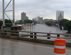
The great Iowa flood of 2008
affected the same section of I-380 at the Iowa River in much the same fashion as in 1993.
I-380 and former Iowa 965 were closed at the Iowa River on June 13 until July 3. In Cedar Rapids, flooding did not close I-380, the only bridge not to close, though traffic was restricted through the city. The flooding damage was much more severe in Cedar Rapids than in Iowa City. The Cedar River crested at over 31 feet (9.4 m) on June 13, causing hundreds of millions of dollars in damage.
Iowa
Iowa is a state located in the Midwestern United States, an area often referred to as the "American Heartland". It derives its name from the Ioway people, one of the many American Indian tribes that occupied the state at the time of European exploration. Iowa was a part of the French colony of New...
. The route extends from Interstate 80 near Coralville
Coralville, Iowa
Coralville is a city in Johnson County, Iowa, United States. It is a suburb of Iowa City and part of the Iowa City Metropolitan Statistical Area...
to Waterloo
Waterloo, Iowa
Waterloo is a city in and the county seat of Black Hawk County, Iowa, United States. As of the 2010 United States Census the population decreased by 0.5% to 68,406. Waterloo is part of the Waterloo – Cedar Falls Metropolitan Statistical Area, and is the more populous of the two...
. I-380 connects the cities of Cedar Rapids
Cedar Rapids, Iowa
Cedar Rapids is the second largest city in Iowa and is the county seat of Linn County. The city lies on both banks of the Cedar River, north of Iowa City and east of Des Moines, the state's capital and largest city...
and Waterloo, the second- and fifth-largest cities in the state, respectively, to the Interstate Highway System
Interstate Highway System
The Dwight D. Eisenhower National System of Interstate and Defense Highways, , is a network of limited-access roads including freeways, highways, and expressways forming part of the National Highway System of the United States of America...
. Except for its last 1+1/2 mi north of U.S. Route 20 (US 20), I-380 runs concurrent
Concurrency (road)
A concurrency, overlap, or coincidence in a road network is an instance of one physical road bearing two or more different highway, motorway, or other route numbers...
with Iowa Highway 27, which represents Iowa's portion of the 560 miles (901.2 km) Avenue of the Saints Highway
Avenue of the Saints
The Avenue of the Saints is a highway in the Midwestern United States that connects St. Paul, Minnesota, and St. Louis, Missouri.-Missouri:Within Missouri, the Avenue of the Saints is Interstate 64, U.S...
connecting St. Louis, Missouri
St. Louis, Missouri
St. Louis is an independent city on the eastern border of Missouri, United States. With a population of 319,294, it was the 58th-largest U.S. city at the 2010 U.S. Census. The Greater St...
, with St. Paul, Minnesota.
Construction of I-380 took 12 years to complete, ending in 1985. After the interstate opened, US 218
U.S. Route 218
U.S. Route 218 is an original United States Highway, created in 1926. Although technically a spur of U.S. Route 18, US 218 neither begins nor ends at US 18, but overlaps US 18 for near Charles City, Iowa. US 218 begins at U.S. Route 136 in downtown Keokuk and ends away at...
was moved onto the new freeway. In the 1990s, the I-380 corridor was selected as part of the Avenue of the Saints
Avenue of the Saints
The Avenue of the Saints is a highway in the Midwestern United States that connects St. Paul, Minnesota, and St. Louis, Missouri.-Missouri:Within Missouri, the Avenue of the Saints is Interstate 64, U.S...
corridor, which Iowa designated as Iowa Highway 27 in 2001. I-380 has been affected by two major floods, the Great Flood of 1993
Great Flood of 1993
The Great Mississippi and Missouri Rivers Flood of 1993 occurred in the American Midwest, along the Mississippi and Missouri rivers and their tributaries, from April to October 1993. The flood was among the most costly and devastating to ever occur in the United States, with $15 billion in damages...
and the Iowa flood of 2008
Iowa flood of 2008
The Iowa flood of 2008 was a hydrological event involving most of the rivers in eastern Iowa beginning around June 8, 2008 and ending about July 1. Flooding continued on the Upper Mississippi River in the southeastern portion of the state for several more days...
, both of which closed the road at the Iowa River
Iowa River
The Iowa River is a tributary of the Mississippi River in the state of Iowa in the United States. It is about long and is open to small river craft to Iowa City, about from its mouth...
for two weeks.
Route description
Interstate 380 begins at a cloverleaf interchangeCloverleaf interchange
A cloverleaf interchange is a two-level interchange in which left turns, reverse direction in left-driving regions, are handled by ramp roads...
where US 218
U.S. Route 218
U.S. Route 218 is an original United States Highway, created in 1926. Although technically a spur of U.S. Route 18, US 218 neither begins nor ends at US 18, but overlaps US 18 for near Charles City, Iowa. US 218 begins at U.S. Route 136 in downtown Keokuk and ends away at...
and Iowa 27 cross Interstate 80 in Coralville
Coralville, Iowa
Coralville is a city in Johnson County, Iowa, United States. It is a suburb of Iowa City and part of the Iowa City Metropolitan Statistical Area...
in Johnson County
Johnson County, Iowa
-2010 census:The 2010 census recorded a population of 130,882 in the county, with a population density of . There were 55,967 housing units, of which 52,715 were occupied.-2000 census:...
. From the interchange, I-380, US 218, and Iowa 27, the route assigned to the Avenue of the Saints Highway
Avenue of the Saints
The Avenue of the Saints is a highway in the Midwestern United States that connects St. Paul, Minnesota, and St. Louis, Missouri.-Missouri:Within Missouri, the Avenue of the Saints is Interstate 64, U.S...
in Iowa, run together
Concurrency (road)
A concurrency, overlap, or coincidence in a road network is an instance of one physical road bearing two or more different highway, motorway, or other route numbers...
towards Cedar Rapids
Cedar Rapids, Iowa
Cedar Rapids is the second largest city in Iowa and is the county seat of Linn County. The city lies on both banks of the Cedar River, north of Iowa City and east of Des Moines, the state's capital and largest city...
. The interstate heads north and serves North Liberty
North Liberty, Iowa
North Liberty is a city in Johnson County, Iowa, United States. It is a suburb of Iowa City and part of the Iowa City Metropolitan Statistical Area....
. North of North Liberty, the freeway runs parallel to the former routing of US 218 and Iowa 965; here the two highways cross the Iowa River
Iowa River
The Iowa River is a tributary of the Mississippi River in the state of Iowa in the United States. It is about long and is open to small river craft to Iowa City, about from its mouth...
. After crossing into Linn County
Linn County, Iowa
-2010 census:The 2010 census recorded a population of 211,226 in the county, with a population density of . There were 92,251 housing units, of which 86,134 were occupied.-2000 census:...
, the three routes enter the Cedar Rapids city limits near The Eastern Iowa Airport
The Eastern Iowa Airport
The Eastern Iowa Airport is a commercial airport in Cedar Rapids, Iowa, in the United States. The airport serves Cedar Rapids, Iowa City, and other communities in eastern Iowa...
. Three miles (4.8 km) north of the airport, I-380 intersects US 30 and US 151
U.S. Route 151
U.S. Route 151 is a U.S. Highway that runs through the states of Iowa and Wisconsin. The southern terminus for U.S. 151 is at a junction with Interstate 80 in Iowa County, Iowa, and its northern terminus is at Manitowoc, Wisconsin. The route, from south to north follows a northeasterly path through...
at a stack interchange
Stack interchange
A stack interchange is a free-flowing grade separated junction between two roads.In countries where one drives on the right, left turns are handled by semi-directional flyover/under ramps...
. At this interchange, US 218 splits away from I-380 and Iowa 27.
Through Cedar Rapids, the I-380 freeway is elevated relative to the nearby streets and residential neighborhoods. As it approaches downtown and the Cedar River, the freeway takes a tight, 90-degree turn to the east, crosses the river, squeezes between a Quaker Oats plant and the U.S. Cellular Center
U.S. Cellular Center
The U.S. Cellular Center is a multi-purpose arena, located in the downtown section of Cedar Rapids, Iowa. It was financed by the approval of a voter referendum to allocate special municipal capital improvement bond monies, after several prior bond referendums to build a civic center failed between...
before turning back 90 degrees to the north. Between downtown and the Coldstream–29th Street interchange, I-380 serves as a dividing line between residential areas to the east and industry to the west. Towards the north end of Cedar Rapids, industry is replaced with commerce as I-380/Iowa 27 meet Iowa 100, locally known as Collins Road, at a volleyball interchange
Volleyball interchange
A three-level diamond interchange is a type of highway interchange where through traffic on both main roads is grade-separated from intersections which handle transferring traffic...
. The collector/distributor ramps for Collins Road also serve the same function for Blairs Ferry Road, the next overpass to the north.
The freeway leaves Cedar Rapids and enters Hiawatha
Hiawatha, Iowa
Hiawatha is a city in Linn County, Iowa, United States. It is a suburb located north of Cedar Rapids and is part of the Cedar Rapids Metropolitan Statistical Area...
, where there is only one interchange, a diamond
Diamond interchange
A diamond interchange is a common type of road junction, used where a freeway crosses a minor road. The freeway itself is grade-separated from the minor road, one crossing the other over a bridge...
with Boyson Road. Quickly escaping the Cedar Rapids area, I-380 turns to the northwest and passes through predominantly rural areas with small communities and farms dotting the way. Because of its northwestern angle, I-380 enters four counties within 30 miles (48.3 km), as counties in Iowa are generally rectangular in shape. It passes Center Point
Center Point, Iowa
Center Point is a city in Linn County, Iowa, United States. The population was 2,007 at the 2000 census. It is part of the Cedar Rapids Metropolitan Statistical Area.-Geography:Center Point is located at ....
in northwestern Linn County, Urbana
Urbana, Iowa
Urbana is a city in Benton County, Iowa, United States. The population was 1,019 at the 2000 census. It is part of the Cedar Rapids Metropolitan Statistical Area.-Geography:Urbana is located at ....
in northeastern Benton County
Benton County, Iowa
-2010 census:The 2010 census recorded a population of 26,076 in the county, with a population density of . There were 11,095 housing units, of which 10,302 were occupied.-2000 census:...
, where it meets Iowa 150, and Brandon
Brandon, Iowa
Brandon is a city in Buchanan County, Iowa, United States. The population was 311 at the 2000 census.-Geography:Brandon is located at .According to the United States Census Bureau, the city has a total area of , all of it land....
in southwestern Buchanan County
Buchanan County, Iowa
-2010 census:The 2010 census recorded a population of 20,958 in the county, with a population density of . There were 8,968 housing units, of which 8,161 were occupied.-2000 census:...
. The interstate travels into Black Hawk County
Black Hawk County, Iowa
-2010 census:The 2010 census recorded a population of 131,090 in the county, with a population density of . There were 55,887 housing units, of which 52,470 were occupied.-2000 census:...
heading northwest for 7 miles (11.3 km) before turning north for 3 miles (4.8 km) until a directional T interchange with US 20.
Together with US 20, I-380 and Iowa 27 travel west towards Waterloo
Waterloo, Iowa
Waterloo is a city in and the county seat of Black Hawk County, Iowa, United States. As of the 2010 United States Census the population decreased by 0.5% to 68,406. Waterloo is part of the Waterloo – Cedar Falls Metropolitan Statistical Area, and is the more populous of the two...
and Cedar Falls
Cedar Falls, Iowa
Cedar Falls is a city in Black Hawk County, Iowa, United States, and it is home to one of Iowa's three public universities, the University of Northern Iowa. The population was 39,260 in the 2010 census, an increase from the 36,145 population in the 2000 census...
. The three routes pass the eastern Waterloo suburbs of Raymond
Raymond, Iowa
Raymond is a city in Black Hawk County, Iowa, United States. The population was 537 at the 2000 census. It is part of the Waterloo–Cedar Falls Metropolitan Statistical Area.-Geography:Raymond is located at ....
, Evansdale
Evansdale, Iowa
Evansdale is a city in Black Hawk County, Iowa, United States. The population was 4,751 in the 2010 census, an increase from 4,526 in the 2000 census. It is part of the Waterloo–Cedar Falls Metropolitan Statistical Area.-Geography:...
, and Elk Run Heights
Elk Run Heights, Iowa
Elk Run Heights is a city in Black Hawk County, Iowa, United States. The population was 1,052 at the 2000 census. It is part of the Waterloo–Cedar Falls Metropolitan Statistical Area.-Geography:Elk Run Heights is located at ....
. Almost immediately after crossing the Cedar River again, I-380 splits away from US 20 and Iowa 27 and rejoins US 218 at a three-level stack interchange. I-380 and US 218 head north to the east of the Crossroads Center
Crossroads Center (Waterloo, IA)
Crossroads Center is a shopping mall located in Waterloo, Iowa. It is the dominant shopping center in northeast Iowa with a trade area that extends more than . The mall opened in 1970, and is owned by Jones Lang LaSalle...
shopping mall. One half-mile (0.8 km) north of the interchange which serves the Crossroads Center, I-380 ends at the traffic light
Traffic light
Traffic lights, which may also be known as stoplights, traffic lamps, traffic signals, signal lights, robots or semaphore, are signalling devices positioned at road intersections, pedestrian crossings and other locations to control competing flows of traffic...
at Mitchell Avenue. US 218 continues to the north at this point.
History
The first section of I-380 opened to traffic on September 19, 1973. That section connected The Eastern Iowa Airport to I-80 at Coralville. Within three years, the interstate had been extended into Cedar Rapids at the Cedar River. The bridge which crossed the river would not open until June 1979. By the end of 1981, I-380 was a continuous road to the Coldstream Avenue/Glass Road interchange. The interstate was originally scheduled to be open by Christmas 1984, but weather delays pushed back the construction timetable. The last section of I-380 to be completed opened on September 12, 1985.In 1985, US 218 was bypassed around Iowa City and Coralville, joining I-380 at the I-80 interchange. US 218 to Cedar Rapids was replaced by Iowa 965. In the early 1990s, most of I-380 was designated as part of the Avenue of the Saints
Avenue of the Saints
The Avenue of the Saints is a highway in the Midwestern United States that connects St. Paul, Minnesota, and St. Louis, Missouri.-Missouri:Within Missouri, the Avenue of the Saints is Interstate 64, U.S...
corridor, which connects St. Louis, Missouri
St. Louis, Missouri
St. Louis is an independent city on the eastern border of Missouri, United States. With a population of 319,294, it was the 58th-largest U.S. city at the 2010 U.S. Census. The Greater St...
, to St. Paul, Minnesota. Avenue of the Saints route markers were erected along the route the next year. In August 2001, the Avenue of the Saints in Iowa was given a single designation, Iowa 27, to facilitate following the route through the state.
I-380 crosses two of Iowa's major rivers, the Iowa
Iowa River
The Iowa River is a tributary of the Mississippi River in the state of Iowa in the United States. It is about long and is open to small river craft to Iowa City, about from its mouth...
and the Cedar. Both rivers have affected the interstate during major floods, as the case was in 1993 and in 2008. During the Great Flood of 1993
Great Flood of 1993
The Great Mississippi and Missouri Rivers Flood of 1993 occurred in the American Midwest, along the Mississippi and Missouri rivers and their tributaries, from April to October 1993. The flood was among the most costly and devastating to ever occur in the United States, with $15 billion in damages...
, I-380 and Iowa 965 were both closed at the Iowa River's Coralville Lake
Coralville Lake
Coralville Lake is a reservoir formed by Coralville Dam, a dam on the Iowa River just upstream from the city of Coralville, Iowa. Construction started in 1949, was delayed by the Korean War, and finally finished in 1958...
reservoir between July 13 and July 28. The roads reopened after the lake's waters receded enough to allow Department of Transportation
Iowa Department of Transportation
In the U.S. state of Iowa, the Iowa Department of Transportation is the state government organization responsible for the organization, construction, and maintenance of the primary highway system...
inspectors to check the three bridges over the water.
The great Iowa flood of 2008
Iowa flood of 2008
The Iowa flood of 2008 was a hydrological event involving most of the rivers in eastern Iowa beginning around June 8, 2008 and ending about July 1. Flooding continued on the Upper Mississippi River in the southeastern portion of the state for several more days...
affected the same section of I-380 at the Iowa River in much the same fashion as in 1993.
I-380 and former Iowa 965 were closed at the Iowa River on June 13 until July 3. In Cedar Rapids, flooding did not close I-380, the only bridge not to close, though traffic was restricted through the city. The flooding damage was much more severe in Cedar Rapids than in Iowa City. The Cedar River crested at over 31 feet (9.4 m) on June 13, causing hundreds of millions of dollars in damage.