
Interstate 64 in Virginia
Encyclopedia
In the U.S. state
of Virginia
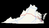
, Interstate 64
runs east–west through the middle of the state from West Virginia
to the Hampton Roads
region, a total of 298 miles (479.6 km). It is notable for crossing the mouth of the harbor of Hampton Roads on the Hampton Roads Bridge-Tunnel
, the first bridge-tunnel
to incorporate man-made islands. Also noteworthy is a section through Rockfish Gap
, a wind gap in the Blue Ridge Mountains
, which was equipped with an innovative system of airport-style runway lighting embedded into the pavement to aid motorists during periods of poor visibility due to fog or other conditions.
in the Shenandoah Valley
. From Staunton, I-64 leaves I-81 and passes through Waynesboro
and crosses Afton Mountain and passes by Charlottesville to reach Richmond. Through Richmond, I-64 overlaps Interstate 95
for several miles. From Richmond, I-64 continues southeasterly past Williamsburg
and through Newport News and Hampton on the Virginia Peninsula
to reach the Hampton Roads Bridge-Tunnel
which it utilizes to cross the main shipping channel at the entrance to the harbor of Hampton Roads from the Chesapeake Bay
. In South Hampton Roads
, I-64 passes through Norfolk and a portion of Virginia Beach
to end in Chesapeake at Bowers Hill, where it meets both the western terminus of Interstate 264
and the southern terminus of Interstate 664
near the northeastern corner of the Great Dismal Swamp
.
Since 2006, from Exit 200 (Interstate 295
) to Exit 273 (U.S. Route 60 east of the Hampton Roads Bridge-Tunnel
), a contraflow lane reversal
system is in place to hasten an evacuation of the Hampton Roads
area. Hurricane gates are installed at eastbound Interstate 64 entrance and exit ramps, and crossover roads are in place near the aforementioned exits. During a hurricane evacuation, the eastbound lanes of I-64 will be reversed into westbound lanes so hundreds of thousands of residents can evacuate.
 A portion of Interstate 64 between the Blue Ridge Mountains
and Short Pump
in Henrico County closely follows the path of the historic colonial-era Three Notch'd Road
, which has been established in the Colony of Virginia by the 1730s, and was largely replaced in the 1930s by U.S. Route 250
.
From the time it was added to the proposed Interregional Highway System, I-64 was to use the U.S. Route 250 alignment west of Richmond. In the late 1950s, a number of interested citizens proposed that I-64 be realigned to run along U.S. Route 220, U.S. Route 460, State Route 307, and U.S. Route 360 from Clifton Forge via Cloverdale
(near Roanoke), Lynchburg, and Farmville to Richmond. The state continued planning for the piece of the US 250 alignment from Richmond to Short Pump
, which would be needed anyway to handle traffic.
The first section of I-64 to open to traffic was in November 1957 with the six-mile (10 km) section in Hampton from VA-134 Magruder Boulevard to the Hampton Roads Bridge-Tunnel
, which had only recently been completed as a two-lane facility built with non-interstate highway toll revenue bond
funding. The second tube and four-laning of approaches to the bridge-tunnel
was accomplished almost 20 years later with federal Interstate Highway funds and the tolls were removed at that time.
forms part of the Hampton Roads Beltway
, a circumferential highway which passes through the major cities of Hampton Roads
. At the terminus of I-64, Interstate 664 begins, passing through Chesapeake
, Portsmouth
and Suffolk
before crossing the harbor via the Monitor-Merrimac Memorial Bridge-Tunnel
to reach Newport News and Hampton, completing the loop. The beltway is signed Inner Loop and Outer Loop to help avoid confusion.
The eastern terminus of I-64 is not the road's easternmost point. After crossing Hampton Roads
through the Hampton Roads Bridge-Tunnel
and entering Norfolk
, the road makes a wide loop toward Virginia Beach and through that city's northwest side. The road then curves toward its final destination on the west side of Chesapeake
. From the point where the road enters Chesapeake, I-64 "east" actually runs westward, ending at a location known as Bowers Hill near the edge of the Great Dismal Swamp
where it becomes Interstate 664
. Today, I-64 is no longer signed as east or west between Bowers Hill and the east junction with I-264
to limit possible confusion; instead it is signed as the inner or outer loop of the Hampton Roads Beltway
. All entrance ramps between these two locations are signed with control cities that differ according to the location of the exit. For inner (westbound) traffic, Suffolk
is the most common control city used, although Norfolk is used at two entrances in Chesapeake to indicate the most direct route to Norfolk (via Interstate 464
). For outer (eastbound) traffic, Norfolk, Hampton, and Virginia Beach are variously used.
Interstate 64 in the Hampton Roads
area is gradually being augmented with HOV
-2 lanes. In the 1990s, reversible HOV-2 lanes were added between I-564
and I-264
. A relatively simple design, it allows only direct exits to the aforementioned termini, slip ramps beyond them, and an additional pair of slip ramps just west (compass north) of the I-264
interchange. The reversible lanes operate westbound from around midnight to noon and eastbound from around noon to midnight. HOV restrictions are only in place during rush hour periods; at other times, any vehicle may use the lanes except during reversals at noon and midnight. Access is controlled by clock-controlled automated gates, and each ramp has multiple gates to provide a safeguard against malfunction. Beyond the reversible lanes, increasing lengths of Interstate 64 (and its spur routes) are receiving HOV-designated left lanes, subject to restrictions during rush hours. Such extensions are ongoing.
Interstate 64 has two three-digit bypasses that are shorter than the main leg for through traffic, both in the Hampton Roads area. Interstate 664
, which connects the Virginia Peninsula
to South Hampton Roads
on the western side of Chesapeake (and to the eastern terminus of I-64), is about 15 miles (24 km) shorter than the bypassed main leg. Interstate 264
, which passes through downtown Norfolk, is about a mile (1.6 km) shorter than the main leg it bypasses.
Interstate 64 passes through the historic African-American neighborhood of Jackson Ward in Richmond, Va. When the interstate was being built in the late 1950s, a cemetery was displaced, resulting in several coffins being forced into the James River. The builders of the interstate also destroyed a house on Fifth Street, which was the birthplace of legendary dancer Bill "Bojangles" Robinson.
U.S. state
A U.S. state is any one of the 50 federated states of the United States of America that share sovereignty with the federal government. Because of this shared sovereignty, an American is a citizen both of the federal entity and of his or her state of domicile. Four states use the official title of...
of Virginia
Virginia
The Commonwealth of Virginia , is a U.S. state on the Atlantic Coast of the Southern United States. Virginia is nicknamed the "Old Dominion" and sometimes the "Mother of Presidents" after the eight U.S. presidents born there...
, Interstate 64
Interstate 64
Interstate 64 is an Interstate Highway in the Midwestern and Southeastern United States. Its western terminus is at I-70, U.S. 40, and U.S. 61 in Wentzville, Missouri. Its eastern terminus is at an interchange with I-264 and I-664 at Bowers Hill in Chesapeake, Virginia. As I-64 is concurrent with...
runs east–west through the middle of the state from West Virginia
West Virginia
West Virginia is a state in the Appalachian and Southeastern regions of the United States, bordered by Virginia to the southeast, Kentucky to the southwest, Ohio to the northwest, Pennsylvania to the northeast and Maryland to the east...
to the Hampton Roads
Hampton Roads
Hampton Roads is the name for both a body of water and the Norfolk–Virginia Beach metropolitan area which surrounds it in southeastern Virginia, United States...
region, a total of 298 miles (479.6 km). It is notable for crossing the mouth of the harbor of Hampton Roads on the Hampton Roads Bridge-Tunnel
Hampton Roads Bridge-Tunnel
The Hampton Roads Bridge-Tunnel is the -long Hampton Roads crossing for Interstate 64 and U.S. Route 60. It is a four-lane facility comprising bridges, trestles, man-made islands, and tunnels under the main shipping channels for Hampton Roads harbor in the southeastern portion of Virginia in the...
, the first bridge-tunnel
Bridge-tunnel
A fixed link, fixed crossing, or bridge-tunnel is a persistent, unbroken road or rail connection across water that uses some combination of bridges, tunnels, and causeways and does not involve intermittent connections such as drawbridges or ferries.The Confederation Bridge was commonly referred to...
to incorporate man-made islands. Also noteworthy is a section through Rockfish Gap
Rockfish Gap
Rockfish Gap is a wind gap located in the Blue Ridge Mountains between Charlottesville and Waynesboro, Virginia, United States, through Afton Mountain, which is frequently used to refer to the gap....
, a wind gap in the Blue Ridge Mountains
Blue Ridge Mountains
The Blue Ridge Mountains are a physiographic province of the larger Appalachian Mountains range. This province consists of northern and southern physiographic regions, which divide near the Roanoke River gap. The mountain range is located in the eastern United States, starting at its southern-most...
, which was equipped with an innovative system of airport-style runway lighting embedded into the pavement to aid motorists during periods of poor visibility due to fog or other conditions.
Route description
Entering from West Virginia, I-64 passes through Covington, to Lexington. From Lexington to Staunton I-64 overlaps Interstate 81Interstate 81
Interstate 81 is an Interstate Highway in the eastern part of the United States. Its southern terminus is at Interstate 40 in Dandridge, Tennessee; its northern terminus is on Wellesley Island at the Canadian border, where the Thousand Islands Bridge connects it to Highway 401, the main freeway...
in the Shenandoah Valley
Shenandoah Valley
The Shenandoah Valley is both a geographic valley and cultural region of western Virginia and West Virginia in the United States. The valley is bounded to the east by the Blue Ridge Mountains, to the west by the eastern front of the Ridge-and-Valley Appalachians , to the north by the Potomac River...
. From Staunton, I-64 leaves I-81 and passes through Waynesboro
Waynesboro, Virginia
Waynesboro, deriving its name from General Anthony Wayne, is an independent city surrounded by Augusta County in the U.S. state of Virginia. The population was 21,006 in 2010.....
and crosses Afton Mountain and passes by Charlottesville to reach Richmond. Through Richmond, I-64 overlaps Interstate 95
Interstate 95 in Virginia
In the Commonwealth of Virginia, Interstate 95 runs through the state. It runs concurrently for with Interstate 64 in Richmond, and meets the northern terminus of Interstate 85 in Petersburg. Though Interstate 95 was originally planned to go straight through Washington, D.C., it was instead...
for several miles. From Richmond, I-64 continues southeasterly past Williamsburg
Williamsburg, Virginia
Williamsburg is an independent city located on the Virginia Peninsula in the Hampton Roads metropolitan area of Virginia, USA. As of the 2010 Census, the city had an estimated population of 14,068. It is bordered by James City County and York County, and is an independent city...
and through Newport News and Hampton on the Virginia Peninsula
Virginia Peninsula
The Virginia Peninsula is a peninsula in southeast Virginia, USA, bounded by the York River, James River, Hampton Roads and Chesapeake Bay.Hampton Roads is the common name for the metropolitan area that surrounds the body of water of the same name...
to reach the Hampton Roads Bridge-Tunnel
Hampton Roads Bridge-Tunnel
The Hampton Roads Bridge-Tunnel is the -long Hampton Roads crossing for Interstate 64 and U.S. Route 60. It is a four-lane facility comprising bridges, trestles, man-made islands, and tunnels under the main shipping channels for Hampton Roads harbor in the southeastern portion of Virginia in the...
which it utilizes to cross the main shipping channel at the entrance to the harbor of Hampton Roads from the Chesapeake Bay
Chesapeake Bay
The Chesapeake Bay is the largest estuary in the United States. It lies off the Atlantic Ocean, surrounded by Maryland and Virginia. The Chesapeake Bay's drainage basin covers in the District of Columbia and parts of six states: New York, Pennsylvania, Delaware, Maryland, Virginia, and West...
. In South Hampton Roads
South Hampton Roads
South Hampton Roads is a region located in the extreme southeastern portion of Virginia in the United States, and is part of the Virginia Beach-Norfolk-Newport News, VA-NC MSA with a population about 1.7 million....
, I-64 passes through Norfolk and a portion of Virginia Beach
Virginia Beach, Virginia
Virginia Beach is an independent city located in the Hampton Roads metropolitan area of Virginia, on the Atlantic Ocean at the mouth of the Chesapeake Bay...
to end in Chesapeake at Bowers Hill, where it meets both the western terminus of Interstate 264
Interstate 264 (Virginia)
Interstate 264 is an Interstate Highway in the U.S. state of Virginia. It runs from a junction with Interstate 64 and Interstate 664 near Bowers Hill in Chesapeake east into Portsmouth and through the Downtown Tunnel under the South Branch of the Elizabeth River into Norfolk...
and the southern terminus of Interstate 664
Interstate 664
Interstate 664 is an Interstate Highway in the U.S. state of Virginia. The Interstate runs from I-64 and I-264 in Chesapeake north to I-64 in Hampton. I-664 forms the west side of the Hampton Roads Beltway, a circumferential highway serving the Hampton Roads metropolitan area...
near the northeastern corner of the Great Dismal Swamp
Great Dismal Swamp
The Great Dismal Swamp is a marshy area on the Coastal Plain Region of southeastern Virginia and northeastern North Carolina between Norfolk, Virginia, and Elizabeth City, North Carolina in the United States. It is located in parts of southern Chesapeake and Suffolk in Virginia, as well as northern...
.
Since 2006, from Exit 200 (Interstate 295
Interstate 295 (Virginia)
Interstate 295 is an eastern and northern bypass of the cities of Richmond and Petersburg in the U.S. state of Virginia. The southern terminus is a junction with Interstate 95 southeast of Petersburg...
) to Exit 273 (U.S. Route 60 east of the Hampton Roads Bridge-Tunnel
Hampton Roads Bridge-Tunnel
The Hampton Roads Bridge-Tunnel is the -long Hampton Roads crossing for Interstate 64 and U.S. Route 60. It is a four-lane facility comprising bridges, trestles, man-made islands, and tunnels under the main shipping channels for Hampton Roads harbor in the southeastern portion of Virginia in the...
), a contraflow lane reversal
Contraflow lane reversal
Contraflow lane reversal refers to plans that alter the normal flow of traffic, typically on a controlled-access highway , to either aid in an emergency evacuation or, as part of routine maintenance activities, to facilitate widening or reconstruction of one of the highway's carriageways...
system is in place to hasten an evacuation of the Hampton Roads
Hampton Roads
Hampton Roads is the name for both a body of water and the Norfolk–Virginia Beach metropolitan area which surrounds it in southeastern Virginia, United States...
area. Hurricane gates are installed at eastbound Interstate 64 entrance and exit ramps, and crossover roads are in place near the aforementioned exits. During a hurricane evacuation, the eastbound lanes of I-64 will be reversed into westbound lanes so hundreds of thousands of residents can evacuate.
History
Blue Ridge Mountains
The Blue Ridge Mountains are a physiographic province of the larger Appalachian Mountains range. This province consists of northern and southern physiographic regions, which divide near the Roanoke River gap. The mountain range is located in the eastern United States, starting at its southern-most...
and Short Pump
Short Pump, Virginia
Short Pump is a census-designated place in Henrico County, Virginia, United States. The population was 182 at the 2000 census.The village of Short Pump, located at the intersection of Three Chopt Road, Richmond Turnpike and Pouncey Tract Road, was named for the short handled pump beneath the...
in Henrico County closely follows the path of the historic colonial-era Three Notch'd Road
Three Notch'd Road
Three Notch'd Road was a colonial-era major east-west route across central Virginia. It is believed to have taken its name from a distinctive marking of three notches cut into trees to blaze the trail...
, which has been established in the Colony of Virginia by the 1730s, and was largely replaced in the 1930s by U.S. Route 250
U.S. Route 250 in Virginia
U.S. Route 250 is a part of the U.S. Highway System that runs from Sandusky, Ohio to Richmond, Virginia. In Virginia, the U.S. Highway runs from the West Virginia state line near Hightown east to its eastern terminus at US 360 in Richmond...
.
From the time it was added to the proposed Interregional Highway System, I-64 was to use the U.S. Route 250 alignment west of Richmond. In the late 1950s, a number of interested citizens proposed that I-64 be realigned to run along U.S. Route 220, U.S. Route 460, State Route 307, and U.S. Route 360 from Clifton Forge via Cloverdale
Cloverdale, Virginia
Cloverdale is a census-designated place in Botetourt County, Virginia, United States. The population was 2,986 at the 2000 census. It is part of the Roanoke Metropolitan Statistical Area....
(near Roanoke), Lynchburg, and Farmville to Richmond. The state continued planning for the piece of the US 250 alignment from Richmond to Short Pump
Short Pump, Virginia
Short Pump is a census-designated place in Henrico County, Virginia, United States. The population was 182 at the 2000 census.The village of Short Pump, located at the intersection of Three Chopt Road, Richmond Turnpike and Pouncey Tract Road, was named for the short handled pump beneath the...
, which would be needed anyway to handle traffic.
The first section of I-64 to open to traffic was in November 1957 with the six-mile (10 km) section in Hampton from VA-134 Magruder Boulevard to the Hampton Roads Bridge-Tunnel
Hampton Roads Bridge-Tunnel
The Hampton Roads Bridge-Tunnel is the -long Hampton Roads crossing for Interstate 64 and U.S. Route 60. It is a four-lane facility comprising bridges, trestles, man-made islands, and tunnels under the main shipping channels for Hampton Roads harbor in the southeastern portion of Virginia in the...
, which had only recently been completed as a two-lane facility built with non-interstate highway toll revenue bond
Revenue bond
A revenue bond is a special type of municipal bond distinguished by its guarantee of repayment solely from revenues generated by a specified revenue-generating entity associated with the purpose of the bonds, rather than from a tax...
funding. The second tube and four-laning of approaches to the bridge-tunnel
Bridge-tunnel
A fixed link, fixed crossing, or bridge-tunnel is a persistent, unbroken road or rail connection across water that uses some combination of bridges, tunnels, and causeways and does not involve intermittent connections such as drawbridges or ferries.The Confederation Bridge was commonly referred to...
was accomplished almost 20 years later with federal Interstate Highway funds and the tolls were removed at that time.
Hampton Roads Beltway
I-64 east from a point near the Hampton ColiseumHampton Coliseum
The Hampton Coliseum is a multi-use cultural, entertainment and sports arena in Hampton, Virginia. Construction on the arena began on May 24, 1968 and the venue opened in 1970 as the first large multi-purpose arena in the Hampton Roads region and the state of Virginia, opening a year prior to...
forms part of the Hampton Roads Beltway
Hampton Roads Beltway
The Hampton Roads Beltway is a loop of Interstate 64 and Interstate 664, which links the communities of the Virginia Peninsula and South Hampton Roads which surround the body of water known as Hampton Roads and comprise much of the region of the same name in the southeastern portion of Virginia in...
, a circumferential highway which passes through the major cities of Hampton Roads
Hampton Roads
Hampton Roads is the name for both a body of water and the Norfolk–Virginia Beach metropolitan area which surrounds it in southeastern Virginia, United States...
. At the terminus of I-64, Interstate 664 begins, passing through Chesapeake
Chesapeake, Virginia
As of the census of 2000, there were 199,184 people, 69,900 households, and 54,172 families residing in the city. The population density was 584.6 people per square mile . There were 72,672 housing units at an average density of 213.3 per square mile...
, Portsmouth
Portsmouth, Virginia
Portsmouth is located in the Hampton Roads metropolitan area of the U.S. Commonwealth of Virginia. As of 2010, the city had a total population of 95,535.The Norfolk Naval Shipyard, often called the Norfolk Navy Yard, is a historic and active U.S...
and Suffolk
Suffolk, Virginia
Suffolk is the largest city by area in Virginia, United States, and is located in the Hampton Roads metropolitan area. As of the 2010 census, the city had a total population of 84,585. Its median household income was $57,546.-History:...
before crossing the harbor via the Monitor-Merrimac Memorial Bridge-Tunnel
Monitor-Merrimac Memorial Bridge-Tunnel
Monitor-Merrimac Memorial Bridge-Tunnel is the 4.6 mile-long Hampton Roads crossing for Interstate 664 in the southeastern portion of Virginia in the United States...
to reach Newport News and Hampton, completing the loop. The beltway is signed Inner Loop and Outer Loop to help avoid confusion.
The eastern terminus of I-64 is not the road's easternmost point. After crossing Hampton Roads
Hampton Roads
Hampton Roads is the name for both a body of water and the Norfolk–Virginia Beach metropolitan area which surrounds it in southeastern Virginia, United States...
through the Hampton Roads Bridge-Tunnel
Hampton Roads Bridge-Tunnel
The Hampton Roads Bridge-Tunnel is the -long Hampton Roads crossing for Interstate 64 and U.S. Route 60. It is a four-lane facility comprising bridges, trestles, man-made islands, and tunnels under the main shipping channels for Hampton Roads harbor in the southeastern portion of Virginia in the...
and entering Norfolk
Norfolk, Virginia
Norfolk is an independent city in the Commonwealth of Virginia in the United States. With a population of 242,803 as of the 2010 Census, it is Virginia's second-largest city behind neighboring Virginia Beach....
, the road makes a wide loop toward Virginia Beach and through that city's northwest side. The road then curves toward its final destination on the west side of Chesapeake
Chesapeake, Virginia
As of the census of 2000, there were 199,184 people, 69,900 households, and 54,172 families residing in the city. The population density was 584.6 people per square mile . There were 72,672 housing units at an average density of 213.3 per square mile...
. From the point where the road enters Chesapeake, I-64 "east" actually runs westward, ending at a location known as Bowers Hill near the edge of the Great Dismal Swamp
Great Dismal Swamp
The Great Dismal Swamp is a marshy area on the Coastal Plain Region of southeastern Virginia and northeastern North Carolina between Norfolk, Virginia, and Elizabeth City, North Carolina in the United States. It is located in parts of southern Chesapeake and Suffolk in Virginia, as well as northern...
where it becomes Interstate 664
Interstate 664
Interstate 664 is an Interstate Highway in the U.S. state of Virginia. The Interstate runs from I-64 and I-264 in Chesapeake north to I-64 in Hampton. I-664 forms the west side of the Hampton Roads Beltway, a circumferential highway serving the Hampton Roads metropolitan area...
. Today, I-64 is no longer signed as east or west between Bowers Hill and the east junction with I-264
Interstate 264 (Virginia)
Interstate 264 is an Interstate Highway in the U.S. state of Virginia. It runs from a junction with Interstate 64 and Interstate 664 near Bowers Hill in Chesapeake east into Portsmouth and through the Downtown Tunnel under the South Branch of the Elizabeth River into Norfolk...
to limit possible confusion; instead it is signed as the inner or outer loop of the Hampton Roads Beltway
Hampton Roads Beltway
The Hampton Roads Beltway is a loop of Interstate 64 and Interstate 664, which links the communities of the Virginia Peninsula and South Hampton Roads which surround the body of water known as Hampton Roads and comprise much of the region of the same name in the southeastern portion of Virginia in...
. All entrance ramps between these two locations are signed with control cities that differ according to the location of the exit. For inner (westbound) traffic, Suffolk
Suffolk, Virginia
Suffolk is the largest city by area in Virginia, United States, and is located in the Hampton Roads metropolitan area. As of the 2010 census, the city had a total population of 84,585. Its median household income was $57,546.-History:...
is the most common control city used, although Norfolk is used at two entrances in Chesapeake to indicate the most direct route to Norfolk (via Interstate 464
Interstate 464
Interstate 464 is an Interstate Highway in the U.S. state of Virginia. The highway runs from U.S. Route 17 and Virginia State Route 168 in Chesapeake north to I-264 in Norfolk. I-464 connects two major highway junctions in the South Hampton Roads region...
). For outer (eastbound) traffic, Norfolk, Hampton, and Virginia Beach are variously used.
Interstate 64 in the Hampton Roads
Hampton Roads
Hampton Roads is the name for both a body of water and the Norfolk–Virginia Beach metropolitan area which surrounds it in southeastern Virginia, United States...
area is gradually being augmented with HOV
HOV
HOV may refer to:* High-occupancy vehicle lane* Ørsta-Volda Airport, Hovden in Hovden, Norway* Hovig* A small street gang located in Naperville* see Hov...
-2 lanes. In the 1990s, reversible HOV-2 lanes were added between I-564
Interstate 564
Interstate 564 is an Interstate Highway in the U.S. state of Virginia. Known as Admiral Taussig Boulevard, the Interstate runs from Virginia State Route 337 east to I-64 within the city of Norfolk. I-564 is the primary access highway to Naval Station Norfolk, the world's largest naval base...
and I-264
Interstate 264 (Virginia)
Interstate 264 is an Interstate Highway in the U.S. state of Virginia. It runs from a junction with Interstate 64 and Interstate 664 near Bowers Hill in Chesapeake east into Portsmouth and through the Downtown Tunnel under the South Branch of the Elizabeth River into Norfolk...
. A relatively simple design, it allows only direct exits to the aforementioned termini, slip ramps beyond them, and an additional pair of slip ramps just west (compass north) of the I-264
Interstate 264 (Virginia)
Interstate 264 is an Interstate Highway in the U.S. state of Virginia. It runs from a junction with Interstate 64 and Interstate 664 near Bowers Hill in Chesapeake east into Portsmouth and through the Downtown Tunnel under the South Branch of the Elizabeth River into Norfolk...
interchange. The reversible lanes operate westbound from around midnight to noon and eastbound from around noon to midnight. HOV restrictions are only in place during rush hour periods; at other times, any vehicle may use the lanes except during reversals at noon and midnight. Access is controlled by clock-controlled automated gates, and each ramp has multiple gates to provide a safeguard against malfunction. Beyond the reversible lanes, increasing lengths of Interstate 64 (and its spur routes) are receiving HOV-designated left lanes, subject to restrictions during rush hours. Such extensions are ongoing.
Interstate 64 has two three-digit bypasses that are shorter than the main leg for through traffic, both in the Hampton Roads area. Interstate 664
Interstate 664
Interstate 664 is an Interstate Highway in the U.S. state of Virginia. The Interstate runs from I-64 and I-264 in Chesapeake north to I-64 in Hampton. I-664 forms the west side of the Hampton Roads Beltway, a circumferential highway serving the Hampton Roads metropolitan area...
, which connects the Virginia Peninsula
Virginia Peninsula
The Virginia Peninsula is a peninsula in southeast Virginia, USA, bounded by the York River, James River, Hampton Roads and Chesapeake Bay.Hampton Roads is the common name for the metropolitan area that surrounds the body of water of the same name...
to South Hampton Roads
South Hampton Roads
South Hampton Roads is a region located in the extreme southeastern portion of Virginia in the United States, and is part of the Virginia Beach-Norfolk-Newport News, VA-NC MSA with a population about 1.7 million....
on the western side of Chesapeake (and to the eastern terminus of I-64), is about 15 miles (24 km) shorter than the bypassed main leg. Interstate 264
Interstate 264 (Virginia)
Interstate 264 is an Interstate Highway in the U.S. state of Virginia. It runs from a junction with Interstate 64 and Interstate 664 near Bowers Hill in Chesapeake east into Portsmouth and through the Downtown Tunnel under the South Branch of the Elizabeth River into Norfolk...
, which passes through downtown Norfolk, is about a mile (1.6 km) shorter than the main leg it bypasses.
Interstate 64 passes through the historic African-American neighborhood of Jackson Ward in Richmond, Va. When the interstate was being built in the late 1950s, a cemetery was displaced, resulting in several coffins being forced into the James River. The builders of the interstate also destroyed a house on Fifth Street, which was the birthplace of legendary dancer Bill "Bojangles" Robinson.
Exit list
| County | Location | # Exit number An exit number is a number assigned to a road junction, usually an exit from a freeway. It is usually marked on the same sign as the destinations of the exit, as well as a sign in the gore.... |
Destinations | Notes | |
|---|---|---|---|---|---|
| Old | |||||
| Alleghany Alleghany County, Virginia As of the census of 2000, there were 12,926 people, 5,149 households, and 3,866 families residing in the county. The population density was 29 people per square mile . There were 5,812 housing units at an average density of 13 per square mile... |
1 | 1 | Jerry's Run Trail | ||
| 2 | 7 | Eastbound exit and westbound entrance | |||
| 3 | 10 | East end of US 60 overlap | |||
| City of Covington Covington, Virginia Covington is an independent city in the U.S. state of Virginia, located at the confluence of Jackson River and Dunlap Creek. It is in Alleghany County where it is also the county seat. The population was 5,961 in 2010. The Bureau of Economic Analysis combines the city of Covington with Alleghany... |
4 | 14 | |||
| Alleghany Alleghany County, Virginia As of the census of 2000, there were 12,926 people, 5,149 households, and 3,866 families residing in the county. The population density was 29 people per square mile . There were 5,812 housing units at an average density of 13 per square mile... |
5 | 16 | West end of US 60/US 220 overlap | ||
| 6 | 21 | ||||
| 7 | 24 | ||||
| 8 | 27 | East end of US 220 overlap; Accessibility to Roanoke via US 220 South | |||
| 9 | 29 | ||||
| 10 | 35 | ||||
| Rockbridge Rockbridge County, Virginia As of the census of 2000, there were 20,808 people, 8,486 households, and 6,075 families residing in the county. The population density was 35 people per square mile . There were 9,550 housing units at an average density of 16 per square mile... |
11 | 43 | |||
| 12 | 50 | East end of US 60 overlap | |||
| 13 | 55 | ||||
| 14 | 56 | West end of I-81 overlap | |||
| 53 | 195 | ||||
| 53A | 200 | ||||
| 54 | 205 | ||||
| Augusta Augusta County, Virginia As of the census of 2000, there were 65,615 people, 24,818 households, and 18,911 families residing in the county. The population density was 68 people per square mile . There were 26,738 housing units at an average density of 28 per square mile... |
55 | 213 | Signed as exits 213A (south) and 213B (north) westbound | ||
| 55A | 217 | ||||
| 55B | 220 | ||||
| 15 | 87 | East end of I-81 overlap | |||
| 16 | 91 | ||||
| Waynesboro | 17 | 94 | |||
| 18 | 96 | ||||
| 19 | 99 | Serves the Blue Ridge Parkway Blue Ridge Parkway The Blue Ridge Parkway is a National Parkway and All-American Road in the United States, noted for its scenic beauty. It runs for 469 miles , mostly along the famous Blue Ridge, a major mountain chain that is part of the Appalachian Mountains... and Skyline Drive Skyline Drive Skyline Drive is a 105-mile road that runs the entire length of the National Park Service's Shenandoah National Park in the Blue Ridge Mountains of Virginia, generally along the ridge of the mountains. The scenic drive is particularly popular in the fall when the leaves are changing colors... |
|||
| Nelson Nelson County, Virginia As of the census of 2000, there were 14,445 people, 5,887 households, and 4,144 families residing in the county. The population density was 31 people per square mile . There were 8,554 housing units at an average density of 18 per square mile... |
No interchanges in Nelson County | ||||
| Albemarle Albemarle County, Virginia As of the census of 2000, there were 79,236 people, 31,876 households, and 21,070 families residing in the county. The population density was 110 people per square mile . There were 33,720 housing units at an average density of 47 per square mile... |
20 | 107 | |||
| 21 | 114 | ||||
| 22 | 118 | Signed as exits 118A (south) and 118B (north) | |||
| 23 | 120 | ||||
| 24 | 121 | Signed as exits 121A (south) and 121B (north) eastbound | |||
| 25 | 124 | ||||
| 26 | 129 | ||||
| Fluvanna Fluvanna County, Virginia As of 2002, Fluvanna County's population was 20,047. There are 7,387 households, and 5,702 families residing in the county. The population density was 70 people per square mile . There were 8,018 housing units at an average density of 28 per square mile... |
No interchanges in Fluvanna County | ||||
| Louisa Louisa County, Virginia Louisa County is a county located in the Commonwealth of Virginia. As of 2010, the population was 33,153. The county seat is Louisa.- History :... |
27 | 136 | |||
| 28 | 143 | ||||
| Goochland Goochland County, Virginia Goochland County is a county located in the Commonwealth of Virginia. As of 2010, the population was 21,717. Its county seat is Goochland. It is located in the Richmond-Petersburg region and is a portion of the Richmond Metropolitan Statistical Area .... |
29 | 148 | |||
| 30 | 152 | ||||
| Louisa | 31 | 159 | |||
| Goochland | 32 | 167 | |||
| 33 | 173 | ||||
| 175 | |||||
| Henrico Henrico County, Virginia Henrico is a county located in the Commonwealth of Virginia, a state of the United States. As of 2010, Henrico was home to 306,935 people. It is located in the Richmond-Petersburg region and is a portion of the Richmond Metropolitan Statistical Area... |
34 | 177 | - Washington, Norfolk | ||
| 35 | 178 | Signed as exits 178A (west) and 178B (east) | |||
| 36 | 180 | Gaskins Road | Signed as exits 180A (south) and 180B (north) | ||
| 37 | 181 | Parham Road | Signed as exits 181A (south) and 181B (north) westbound | ||
| 38 | 183 | Signed as exits 183A (Glenside Drive south), 183B (US 250 east), and 183C (US 250 west, Glenside Drive north) westbound | |||
| 39 | 185 | Signed as exits 185A (west) and 185B (east) eastbound | |||
| City of Richmond Richmond, Virginia Richmond is the capital of the Commonwealth of Virginia, in the United States. It is an independent city and not part of any county. Richmond is the center of the Richmond Metropolitan Statistical Area and the Greater Richmond area... |
40 | 186 | Eastbound exit and westbound entrance | ||
| 40 | 186 | ||||
| 41 | 187 | West end of I-95 overlap | |||
| 14 | 78 | Belt Boulevard (SR 161 Virginia State Route 161 State Route 161 is a primary state highway in and near Richmond, Virginia, United States. It extends from an interchange with Interstate 95 in the independent city of Richmond north to an intersection with U.S... ) |
|||
| 13 | 76B | No westbound exit | |||
| 12 | 76A | Chamberlayne Avenue | Westbound exit only | ||
| 43 | 190 | East end of I-95 overlap | |||
| 43 | 190 | 3rd Street, 5th Street - Downtown Richmond Downtown Richmond, Virginia Downtown Richmond, Virginia, is central urban area of that city. It is generally defined as being bound by Belvidere Street to the west, I-95 to the north and east, and the James River to the south.-Description:... , Richmond Coliseum Richmond Coliseum Richmond Coliseum is an arena in Richmond, Virginia, where the SPHL Richmond Renegades played until the 2008-2009 season and the SIFL Richmond Raiders will play starting with the 2010 season. It is also the venue for various large concerts. The arena opened in 1971 and holds 13,500 people. A... |
|||
| 44 | 192 | ||||
| Henrico | 45 | 193 | Signed as exits 193A (west) and 193B (east) | ||
| 46 | 195 | Laburnum Avenue | |||
| 47 | 197 | Signed as exits 197A (south) and 197B (north) | |||
| 48 | 200 | 295 south to US 60. | |||
| New Kent New Kent County, Virginia At the 2000 census, there were 13,462 people, 4,925 households and 3,895 families residing in the county. The population density was 64 per square mile . There were 5,203 housing units at an average density of 25 per square mile... |
49 | 205 | West end of SR 33 overlap | ||
| 50 | 211 | ||||
| 51 | 214 | ||||
| 52 | 220 | East end of SR 33 overlap | |||
| James City James City County, Virginia James City County is a county located on the Virginia Peninsula in the Hampton Roads metropolitan area of the Commonwealth of Virginia, a state of the United States. Its population was 67,009 , and it is often associated with Williamsburg, an independent city, and Jamestown which is within the... |
53 | 227 | |||
| 54 | 231 | Signed as exits 231A (SR 30, Norge) and 231B (Croaker) | |||
| York York County, Virginia York County is a county located on the north side of the Virginia Peninsula in the Hampton Roads metropolitan area of the Commonwealth of Virginia, a state of the United States. Situated on the York River and many tributaries, the county seat is the unincorporated town of Yorktown... |
55 | 234 | Signed as exits 234A (east) and 234B (west) westbound | ||
| 56 | 238 | ||||
| 57 | 242 | Signed as exits 242A (west) and 242B (east) | |||
| 243A | |||||
| 58 | 243B | No entrance ramps | |||
| James City | 59 | 247 | |||
| City of Newport News Newport News, Virginia Newport News is an independent city located in the Hampton Roads metropolitan area of Virginia. It is at the southeastern end of the Virginia Peninsula, on the north shore of the James River extending southeast from Skiffe's Creek along many miles of waterfront to the river's mouth at Newport News... |
|||||
| 60 | 250 | Signed as exits 250A (west) and 250B (east) | |||
| 61 | 255 | Signed as exits 255A (east) and 255B (west) | |||
| 61A | 256 | Oyster Point Road west, Victory Boulevard east (SR 171) - Poquoson | Signed as exits 256A (west) and 256B (east) | ||
| 62 | 258 | Signed as exits 258A (south) and 258B (north) | |||
| City of Hampton Hampton, Virginia Hampton is an independent city that is not part of any county in Southeast Virginia. Its population is 137,436. As one of the seven major cities that compose the Hampton Roads metropolitan area, it is on the southeastern end of the Virginia Peninsula. Located on the Hampton Roads Beltway, it hosts... |
62A | 261A | Hampton Roads Center Parkway west | ||
| 62B | 261B | Hampton Roads Center Parkway east | Eastbound exit and westbound entrance | ||
| 63 | 262B | , NASA Langley Research Center | West end of SR 134 overlap; westbound exit and eastbound entrance | ||
| 64 | 263 | - Hampton Coliseum Hampton Coliseum The Hampton Coliseum is a multi-use cultural, entertainment and sports arena in Hampton, Virginia. Construction on the arena began on May 24, 1968 and the venue opened in 1970 as the first large multi-purpose arena in the Hampton Roads region and the state of Virginia, opening a year prior to... , James River Bridge James River Bridge The James River Bridge is a four-lane divided highway lift bridge across the James River in the U.S. state of Virginia. Owned and operated by the Virginia Department of Transportation, it carries U.S. Route 17, U.S. Route 258, and State Route 32 across the river near its mouth at Hampton Roads... |
Signed as exits 263A (US 258 south) and 263B (US 258 north/SR 134 south) westbound | ||
| 65 | 264 | ||||
| West end of Hampton Roads Beltway Hampton Roads Beltway The Hampton Roads Beltway is a loop of Interstate 64 and Interstate 664, which links the communities of the Virginia Peninsula and South Hampton Roads which surround the body of water known as Hampton Roads and comprise much of the region of the same name in the southeastern portion of Virginia in... overlap; eastbound becomes inner loop and westbound becomes outer loop |
|||||
| 66A | 265A | Former SR 167 south | |||
| 66B | 265B | No inner (eastbound) exit; former SR 167 north | |||
| 67 | 265C | Armistead Avenue (SR 134) - Langley AFB | Inner (eastbound) exit only | ||
| 68 | 267 | Outer (west) end of US 60 overlap | |||
| 69 | 268 | ||||
| Hampton Roads Bridge-Tunnel Hampton Roads Bridge-Tunnel The Hampton Roads Bridge-Tunnel is the -long Hampton Roads crossing for Interstate 64 and U.S. Route 60. It is a four-lane facility comprising bridges, trestles, man-made islands, and tunnels under the main shipping channels for Hampton Roads harbor in the southeastern portion of Virginia in the... across Hampton Roads Hampton Roads Hampton Roads is the name for both a body of water and the Norfolk–Virginia Beach metropolitan area which surrounds it in southeastern Virginia, United States... |
|||||
| City of Norfolk Norfolk, Virginia Norfolk is an independent city in the Commonwealth of Virginia in the United States. With a population of 242,803 as of the 2010 Census, it is Virginia's second-largest city behind neighboring Virginia Beach.... |
|||||
| 70 | 272 | West Ocean View Ave - Willoughby Spit Willoughby Spit Willoughby Spit is a peninsula of land in the independent city of Norfolk, Virginia in the United States. It is bordered by water on three sides: the Chesapeake Bay to the north, Hampton Roads to the west, and Willoughby Bay to the south.- History :... |
Outer (west) end of US 60 west overlap | ||
| 71 | 273 | Outer (west) end of US 60 east overlap | |||
| 72 | 274 | Bay Avenue - Naval Air Station Norfolk | Outer (westbound) exit and inner (eastbound) entrance | ||
| 73 | 276 | Signed as exits 276A (US 460) and 276B (I-564) on outer loop (westbound) | |||
| 74 | 276C | Outer (westbound) exit and inner (eastbound) entrance | |||
| 75 | 277 | Signed as exits 277A (south) and 277B (north) | |||
| 76 | 278 | ||||
| 77 | 279 | Norview Avenue (SR 247) - Norfolk International Airport Norfolk International Airport -Baggage Claims:Southwest Airlines #1,Delta Airlines #2,US Airways | American Airlines #3,Continental Airlines|United Express #5- Facilities and aircraft :... |
Signed as exits 279A (west) and 279B (east) on outer loop (westbound) | ||
| 78 | 281 | Signed as exits 281A (Robin Hood Road) and 281B (SR 165 south) on inner loop (eastbound) | |||
| 79 | 282 | ||||
| 80 | 284 | Signed as exits 284A (west) and 284B (east); inner (eastbound) exit 284A includes a flyover to I-264 east, so exit 284B is signed only for Newtown Road in that direction | |||
| Inner (east) end of signage as east/west; only inner (east)/outer (west) beyond | |||||
| City of Virginia Beach Virginia Beach, Virginia Virginia Beach is an independent city located in the Hampton Roads metropolitan area of Virginia, on the Atlantic Ocean at the mouth of the Chesapeake Bay... |
81 | 286 | Indian River Road | Signed as exits 286A (west) and 286B (east); former SR 407 | |
| City of Chesapeake Chesapeake, Virginia As of the census of 2000, there were 199,184 people, 69,900 households, and 54,172 families residing in the city. The population density was 584.6 people per square mile . There were 72,672 housing units at an average density of 213.3 per square mile... |
82 | 289 | Greenbrier Parkway | Signed as exits 289A (north) and 289B (south) | |
| 83A | 290A | Outer (west) end of SR 168 overlap | |||
| 83B | 290B | ||||
| 84A | 291A | ||||
| 84B | 291B | - Elizabeth City, Nags Head, Great Bridge | Inner (east) end of SR 168 overlap; outer (west) end of US 17 north overlap; access from outer loop (westbound) to US 17 south is at exit 292 | ||
| 85 | 292 | - Elizabeth City | Outer (west) end of US 17 south overlap; outer (westbound) exit only | ||
| 86 | 296 | Inner (east) end of US 17 overlap; signed as exits 296A (north) and 296B (south) on inner loop (eastbound) | |||
| 87 | 297 | ||||
| 88A | 299A | Inner (eastbound) exit and outer (westbound) entrance | |||
| 88B | 299B | Inner (eastbound) exit and outer (westbound) entrance | |||
See also
- Interstate 264Interstate 264 (Virginia)Interstate 264 is an Interstate Highway in the U.S. state of Virginia. It runs from a junction with Interstate 64 and Interstate 664 near Bowers Hill in Chesapeake east into Portsmouth and through the Downtown Tunnel under the South Branch of the Elizabeth River into Norfolk...
- Interstate 464
- Interstate 564
- Interstate 664
- Hampton Roads BeltwayHampton Roads BeltwayThe Hampton Roads Beltway is a loop of Interstate 64 and Interstate 664, which links the communities of the Virginia Peninsula and South Hampton Roads which surround the body of water known as Hampton Roads and comprise much of the region of the same name in the southeastern portion of Virginia in...
- State Route 164