
Mount Mitchell State Park
Encyclopedia
Mount Mitchell State Park is a North Carolina state park in Yancey County
, North Carolina
in the United States
. Established in 1915 by the state legislature, it became the first state park of North Carolina
. By doing so, it also established the North Carolina State Parks System within the same bill.
Located off of NC 128
and the Blue Ridge Parkway
near Burnsville, North Carolina
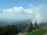
, it includes the peak of Mount Mitchell
, the highest peak east of the Mississippi River
. From the parking lot you can take a short hike to the summit which includes an observation tower and the grave of Elisha Mitchell
, the professor who first noted the mountain's height. The old observation tower was torn down in Early October 2006. The trail leading to the summit has been paved, and a new observation platform was constructed and opened to the public in January 2009. The summit also features an exhibit hall with information about the mountain's natural, cultural and historical heritage.
In addition to Mount Mitchell itself, the park encompasses several other peaks which top out at over 6000' in elevation, including Mount Hallback, Mount Craig
(just 37 feet (11.3 m) shy of Mount Mitchell in Elevation and the second highest peak east of the Mississippi River
), Big Tom and Balsam Cone. Trails lead to all these summits save Mount Hallback, and their exploration takes visitors away from the crowds on Mount Mitchell but to places similarly spectacular. About 8 miles (12.9 km) of trails exist within the park in all.
Another popular destination reachable by trail within the park is Camp Alice, at an elevation of 5800' south of the summit of Mount Mitchell. This historic site is the location of a logging and, later, Civilian Conservation Corps tourist camp at the terminus of the old Mount Mitchell toll road. Lower Creek flows across the main trail at this point and it is one of the highest elevation perennial streams in the Appalachians, flowing through the Spruce-Fir forest. Openings here in the forest surrounded by evergreens resemble such openings near treeline in higher mountain ranges.
The park also serves as the finish line for The Assault on Mount Mitchell
and the midpoint for the Mount Mitchell Challenge
ultramarathon.
Yancey County, North Carolina
-Demographics:As of the census of 2000, there were 17,774 people, 7,472 households, and 5,372 families residing in the county. The population density was 57 people per square mile . There were 9,729 housing units at an average density of 31 per square mile...
, North Carolina
North Carolina
North Carolina is a state located in the southeastern United States. The state borders South Carolina and Georgia to the south, Tennessee to the west and Virginia to the north. North Carolina contains 100 counties. Its capital is Raleigh, and its largest city is Charlotte...
in the United States
United States
The United States of America is a federal constitutional republic comprising fifty states and a federal district...
. Established in 1915 by the state legislature, it became the first state park of North Carolina
North Carolina
North Carolina is a state located in the southeastern United States. The state borders South Carolina and Georgia to the south, Tennessee to the west and Virginia to the north. North Carolina contains 100 counties. Its capital is Raleigh, and its largest city is Charlotte...
. By doing so, it also established the North Carolina State Parks System within the same bill.
Located off of NC 128
North Carolina State Highway 128
North Carolina Highway 128 is a primary state highway in the U.S. state of North Carolina. It runs from the Blue Ridge Parkway to Mount Mitchell State Park. Reaching an elevation of over , it is the highest road or highway east of the Mississippi River.-Route description:The route serves as a...
and the Blue Ridge Parkway
Blue Ridge Parkway
The Blue Ridge Parkway is a National Parkway and All-American Road in the United States, noted for its scenic beauty. It runs for 469 miles , mostly along the famous Blue Ridge, a major mountain chain that is part of the Appalachian Mountains...
near Burnsville, North Carolina
Burnsville, North Carolina
Burnsville is a town in Yancey County, North Carolina, United States. The population was 1,623 at the 2000 census. It is the county seat of Yancey County.-Geography:Burnsville is located at ....
, it includes the peak of Mount Mitchell
Mount Mitchell (North Carolina)
Mount Mitchell is the highest peak of the Appalachian Mountains and the highest peak in the eastern United States. It was the highest point in any state of the United States until Texas joined the union in 1845. The nearest higher point east of the Rocky Mountains is Harney Peak in the Black Hills...
, the highest peak east of the Mississippi River
Mississippi River
The Mississippi River is the largest river system in North America. Flowing entirely in the United States, this river rises in western Minnesota and meanders slowly southwards for to the Mississippi River Delta at the Gulf of Mexico. With its many tributaries, the Mississippi's watershed drains...
. From the parking lot you can take a short hike to the summit which includes an observation tower and the grave of Elisha Mitchell
Elisha Mitchell
Elisha Mitchell was born in Washington, Connecticut. As a professor at the University of North Carolina at Chapel Hill, in 1835, he measured the height of Mt. Mitchell. Mt. Mitchell is the highest point east of the Mississippi River. It is located in North Carolina and is 6,684 feet high...
, the professor who first noted the mountain's height. The old observation tower was torn down in Early October 2006. The trail leading to the summit has been paved, and a new observation platform was constructed and opened to the public in January 2009. The summit also features an exhibit hall with information about the mountain's natural, cultural and historical heritage.
In addition to Mount Mitchell itself, the park encompasses several other peaks which top out at over 6000' in elevation, including Mount Hallback, Mount Craig
Mount Craig (North Carolina)
Mount Craig, , is the second highest peak of the Appalachian Mountains and second only to Mount Mitchell in eastern North America. It is located in the Black Mountains in Yancey County, North Carolina. The mountain lies just north of Mt...
(just 37 feet (11.3 m) shy of Mount Mitchell in Elevation and the second highest peak east of the Mississippi River
Mississippi River
The Mississippi River is the largest river system in North America. Flowing entirely in the United States, this river rises in western Minnesota and meanders slowly southwards for to the Mississippi River Delta at the Gulf of Mexico. With its many tributaries, the Mississippi's watershed drains...
), Big Tom and Balsam Cone. Trails lead to all these summits save Mount Hallback, and their exploration takes visitors away from the crowds on Mount Mitchell but to places similarly spectacular. About 8 miles (12.9 km) of trails exist within the park in all.
Another popular destination reachable by trail within the park is Camp Alice, at an elevation of 5800' south of the summit of Mount Mitchell. This historic site is the location of a logging and, later, Civilian Conservation Corps tourist camp at the terminus of the old Mount Mitchell toll road. Lower Creek flows across the main trail at this point and it is one of the highest elevation perennial streams in the Appalachians, flowing through the Spruce-Fir forest. Openings here in the forest surrounded by evergreens resemble such openings near treeline in higher mountain ranges.
The park also serves as the finish line for The Assault on Mount Mitchell
The Assault on Mount Mitchell
The Assault on Mount Mitchell is an annual bicycling endurance contest in South Carolina and North Carolina first held in 1974. Those completing The Assault on Marion the previous year may enter...
and the midpoint for the Mount Mitchell Challenge
Mount Mitchell Challenge
The Mount Mitchell Challenge is a 40 mile Ultramarathon run in February of each year from the town of Black Mountain, NC to the top of Mt Mitchell, the highest point in the Eastern US, and back down again...
ultramarathon.