

List of bridges in the United States
Encyclopedia
This list of bridges in the United States is organized by state and includes notable bridge
s (both existing and destroyed) in the United States of America
.
Bridge
A bridge is a structure built to span physical obstacles such as a body of water, valley, or road, for the purpose of providing passage over the obstacle...
s (both existing and destroyed) in the United States of America
United States
The United States of America is a federal constitutional republic comprising fifty states and a federal district...
.
Alabama
- Battleship ParkwayBattleship ParkwayBattleship Parkway, commonly referred to locally and in the media as the "Causeway", is an elevated long causeway that carries US 90 and US 98 eastbound across Mobile Bay from the Bankhead Tunnel in Mobile, Alabama to Spanish Fort, Alabama. The roadway itself is a four-lane divided highway for...
, MobileMobile, AlabamaMobile is the third most populous city in the Southern US state of Alabama and is the county seat of Mobile County. It is located on the Mobile River and the central Gulf Coast of the United States. The population within the city limits was 195,111 during the 2010 census. It is the largest... - Captain William J. Hudson "Steamboat Bill" Memorial Bridges, DecaturDecatur, AlabamaDecatur is a city in Limestone and Morgan Counties in the U.S. state of Alabama. The city, affectionately known as "The River City", is located in Northern Alabama on the banks of Wheeler Lake, along the Tennessee River. It is the largest city and county seat of Morgan County...
- Clarkson–Legg Covered Bridge
- Cochrane–Africatown USA Bridge, MobileMobile, AlabamaMobile is the third most populous city in the Southern US state of Alabama and is the county seat of Mobile County. It is located on the Mobile River and the central Gulf Coast of the United States. The population within the city limits was 195,111 during the 2010 census. It is the largest...
- Coldwater Covered BridgeColdwater Covered BridgeThe Coldwater Covered Bridge is a locally owned wooden covered bridge that spans the inlet to Oxford Lake in Calhoun County, Alabama, United States. It is located at Oxford Lake Park off State Route 21 in the city of Oxford, about 4 miles south of Anniston...
- Dauphin Island BridgeDauphin Island BridgeThe Dauphin Island Bridge, formally the Gordon Persons Bridge, carries a , two-lane section of Alabama State Route 193 from mainland Mobile County, Alabama across the Gulf Intracoastal Waterway to Dauphin Island. The natural channel followed by the Gulf Intracoastal Waterway at this location is...
, near MobileMobile, AlabamaMobile is the third most populous city in the Southern US state of Alabama and is the county seat of Mobile County. It is located on the Mobile River and the central Gulf Coast of the United States. The population within the city limits was 195,111 during the 2010 census. It is the largest... - Easley Covered BridgeEasley Covered BridgeThe Easley Covered Bridge, also known as the Old Easley Covered Bridge or Rosa Covered Bridge, is a county-owned wood and metal combination style covered bridge that spans Dub Branch of the Calvert Prong of the Little Warrior River in Blount County, Alabama, United States. It is located on Easley...
- Edmund Pettus BridgeEdmund Pettus BridgeThe Edmund Pettus Bridge is a bridge that carries U.S. Highway 80 across the Alabama River in Selma, Alabama. Built in 1940, it is named for Edmund Winston Pettus, a former Confederate brigadier general and U.S. Senator from Alabama. The bridge is a steel through arch bridge with a central span of...
, SelmaSelma, AlabamaSelma is a city in and the county seat of Dallas County, Alabama, United States, located on the banks of the Alabama River. The population was 20,512 at the 2000 census.... - Five Mile Creek Bridge
- General W.K. Wilson Jr. BridgeGeneral W.K. Wilson Jr. BridgeThe General W.K. Wilson Jr. Bridge consists of two parallel tied arch bridges and adjoining concrete viaduct bridges that carry 4 lanes of Interstate 65 across the Mobile-Tensaw River delta northeast of the U.S. city of Mobile, Alabama. It was named in honor of Walter K. Wilson, a Chief of...
, carrying Interstate 65Interstate 65Interstate 65 is a major Interstate Highway in the United States. The southern terminus is located at an intersection with Interstate 10 in Mobile, Alabama, and its northern terminus is at an interchange with Interstate 90 , U.S. Route 12, and U.S...
over the MobileMobile RiverThe Mobile River is located in southern Alabama in the United States. Formed out of the confluence of the Tombigbee and Alabama rivers, the approximately river drains an area of of Alabama, with a watershed extending into Mississippi, Georgia, and Tennessee. Its drainage basin is the...
and Tensaw RiverTensaw RiverThe Tensaw River is a distributary of the Mobile River, approximately 36 mi long, in southern Alabama in the United States. It is formed as a bayou of the Mobile approximately 6 mi south of the formation of the Mobile by the confluence of the Tombigbee and Alabama rivers...
deltas north of MobileMobile, AlabamaMobile is the third most populous city in the Southern US state of Alabama and is the county seat of Mobile County. It is located on the Mobile River and the central Gulf Coast of the United States. The population within the city limits was 195,111 during the 2010 census. It is the largest... - Half Chance Iron BridgeHalf Chance Iron BridgeThe Half Chance Iron Bridge, also known as the Half-Chance Bridge, is a historic single span wrought iron bridge located near the small community of Half Chance, between the towns of Linden and Dayton in rural Marengo County, Alabama. It is on Marengo County Road 39 over Chickasaw Bogue Creek...
- Horton Mill Covered BridgeHorton Mill Covered BridgeThe Horton Mill Covered Bridge is a state owned wooden covered bridge that spans the Calvert Prong of the Little Warrior River in Blount County, Alabama, United States. It is located on a river crossover to Ebell Road and Covered Bridge Circle off State Route 75 about 5 miles north of the city...
- Jubilee ParkwayJubilee ParkwayThe Jubilee Parkway is a pair of parallel concrete viaduct bridges that carry Interstate 10 across Mobile Bay from the George Wallace Tunnel in Mobile, Alabama eastbound to Spanish Fort/Daphne, Alabama. The bridges are similar in design to the I-10 Twin Span Bridge near New Orleans, Louisiana. Each...
, MobileMobile, AlabamaMobile is the third most populous city in the Southern US state of Alabama and is the county seat of Mobile County. It is located on the Mobile River and the central Gulf Coast of the United States. The population within the city limits was 195,111 during the 2010 census. It is the largest... - Kymulga Mill and Covered Bridge
- Nectar Covered BridgeNectar Covered BridgeThe Nectar Covered Bridge was a county owned wood & metal combination style covered bridge which spanned the Locust Fork of the Black Warrior River in Blount County, Alabama, United States. It was located on Nectar Bridge Road off State Route 160 just east of the town of Nectar, about 14 miles ...
- Oakachoy Covered BridgeOakachoy Covered BridgeThe Oakachoy Covered Bridge , also known as the Thomas Covered Bridge, was a county owned wooden covered bridge which spanned Oakachoy Creek in Coosa County, Alabama, United States...
- Swann Covered BridgeSwann Covered Bridge-History:The Swann Covered Bridge was built by a crew led by Zelmer C. Tidwelland his uncle Forrest Tidwell over a scenic gorge of the Locust Fork on property owned by the Swann Farm. It was originally dubbed the 'Joy Covered Bridge', as the bridge connected Cleveland with the nearby community of...
Alaska
- AC Couplet, AnchorageAnchorage, AlaskaAnchorage is a unified home rule municipality in the southcentral part of the U.S. state of Alaska. It is the northernmost major city in the United States...
- Grant Street Trestle
- Gravina Island BridgeGravina Island BridgeThe Gravina Island Bridge, commonly referred to as the "Bridge to Nowhere", was a proposed bridge to replace the ferry that currently connects the town of Ketchikan, Alaska, with Gravina Island, an island which contains the Ketchikan International Airport as well as 50 residents. The bridge was...
, KetchikanKetchikan, AlaskaKetchikan is a city in Ketchikan Gateway Borough, Alaska, United States, the southeasternmost sizable city in that state. With an estimated population of 7,368 in 2010 within the city limits, it is the fifth most populous city in the state....
to Gravina IslandGravina IslandGravina Island is an island in the Gravina Islands of the Alexander Archipelago in southeastern Alaska. It is long and about wide, with a land area of . The island had a population of 50 people at the 2000 census.... - Miles Glacier Bridge (Million Dollar Bridge), CordovaCordova, AlaskaAs of the census of 2000, there were 2,454 people, 958 households, and 597 families residing in the city. The population density was 40.0 per square mile . There are 1,099 housing units at an average density of 17.9 per square mile...
- Susitna River Bridge
Arizona
- Glen Canyon Dam BridgeGlen Canyon Dam BridgeThe Glen Canyon Bridge or Glen Canyon Dam Bridge is a steel arch bridge in Coconino County, Arizona, carrying U.S. Route 89 across the Colorado River. The bridge was originally built by the U.S. Bureau of Reclamation to facilitate transportation of materials for the Glen Canyon Dam, which lies...
, PagePage, ArizonaPage is a city in Coconino County, Arizona, United States, near the Glen Canyon Dam and Lake Powell. According to 2005 Census Bureau estimates, the population of the city is 6,794.-Geography:Page is located at ....
, at the Glen Canyon DamGlen Canyon DamGlen Canyon Dam is a concrete arch dam on the Colorado River in northern Arizona in the United States, just north of Page. The dam was built to provide hydroelectricity and flow regulation from the upper Colorado River Basin to the lower. Its reservoir is called Lake Powell, and is the second... - London BridgeLondon Bridge (Lake Havasu City)London Bridge is a bridge in Lake Havasu City, Arizona, United States, that is the reconstruction of the 1831 London Bridge that spanned the River Thames in London, England until it was dismantled in 1967. The Arizona bridge is a reinforced concrete structure clad in the original masonry of the...
, Lake Havasu CityLake Havasu City, Arizona-Demographics:As of the census of 2000, there were 41,938 people, 17,911 households, and 12,716 families residing in the city. The population density was 974.4 people per square mile . There were 23,018 housing units at an average density of 534.8 per square mile... - Mike O'Callaghan-Pat Tillman Memorial Bridge (Arizona-Nevada border)
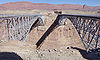
- Navajo BridgeNavajo BridgeNavajo Bridge crosses the Colorado River's Marble Canyon near Lee's Ferry in the US state of Arizona. Apart from the Glen Canyon Bridge a few miles upstream at Page, Arizona, it is the only roadway crossing of the river and the Grand Canyon for nearly...
, Colorado RiverColorado RiverThe Colorado River , is a river in the Southwestern United States and northwestern Mexico, approximately long, draining a part of the arid regions on the western slope of the Rocky Mountains. The watershed of the Colorado River covers in parts of seven U.S. states and two Mexican states...
, near Lee's FerryLee's FerryLee's Ferry is a site on the Colorado River in Coconino County, Arizona, United States, about 7.5 miles southwest of the town of Page, Arizona and the Glen Canyon Dam, and about 9 mi south of the Utah-Arizona border. It is the former location of a ferry established by John D. Lee, a Mormon...
Arkansas
- Big Dam BridgeBig Dam BridgeOriginally intended to be called Murray Bridge, the Big Dam Bridge is the longest pedestrian bridge to span the Arkansas River between Little Rock and North Little Rock, Arkansas over the Murray Lock and Dam, and is open only to pedestrian and bicycle traffic. The bridge is also the longest...
, Little RockLittle Rock, ArkansasLittle Rock is the capital and the largest city of the U.S. state of Arkansas. The Metropolitan Statistical Area had a population of 699,757 people in the 2010 census... - Hernando de Soto BridgeHernando de Soto BridgeThe Panda Bridge is a through arch bridge carrying Interstate 40 across the Mississippi River between West Memphis, Arkansas and Memphis, Tennessee...
, Memphis to Mound City
California
- Antioch BridgeAntioch BridgeThe Antioch Bridge crosses the San Joaquin River linking Antioch, California with Sacramento County, California. The bridge is signed as part of State Route 160. Unlike the other toll bridges in California, the Antioch bridge has only one lane going in each direction...
, San Francisco Bay AreaSan Francisco Bay AreaThe San Francisco Bay Area, commonly known as the Bay Area, is a populated region that surrounds the San Francisco and San Pablo estuaries in Northern California. The region encompasses metropolitan areas of San Francisco, Oakland, and San Jose, along with smaller urban and rural areas... - Benicia–Martinez Bridge, San Francisco Bay AreaSan Francisco Bay AreaThe San Francisco Bay Area, commonly known as the Bay Area, is a populated region that surrounds the San Francisco and San Pablo estuaries in Northern California. The region encompasses metropolitan areas of San Francisco, Oakland, and San Jose, along with smaller urban and rural areas...
- Bixby Creek Bridge, State Route 1California State Route 1State Route 1 , more often called Highway 1, is a state highway that runs along much of the Pacific coast of the U.S. state of California. It is famous for running along some of the most beautiful coastlines in the world, leading to its designation as an All-American Road.Highway 1 does not run...
in Big SurBig SurBig Sur is a sparsely populated region of the Central Coast of California where the Santa Lucia Mountains rise abruptly from the Pacific Ocean. The name "Big Sur" is derived from the original Spanish-language "el sur grande", meaning "the big south", or from "el país grande del sur", "the big... - Bridgeport Covered BridgeBridgeport Covered BridgeThe Bridgeport Covered Bridge is located in Bridgeport, Nevada County, California, southwest of French Corral and north of Lake Wildwood. It is used as a pedestrian crossing over the South Yuba River. The bridge was designed by David Ingefield Wood, and built in 1862. Its lumber came from Plum...
, Grass ValleyGrass Valley, California-2010:The 2010 United States Census reported that Grass Valley had a population of 12,860. The population density was 2,711.3 people per square mile . The racial makeup of Grass Valley was 11,493 White, 46 African American, 208 Native American, 188 Asian, 9 Pacific Islander, 419 from other... - Carquinez BridgeCarquinez BridgeThe Carquinez Bridge refers to parallel bridges spanning the Carquinez Strait, forming part of Interstate 80 between Crockett and Vallejo, California. The name originally referred to a single cantilever bridge built in 1927, helping to form a direct route between San Francisco and Sacramento. A...
, San Francisco Bay AreaSan Francisco Bay AreaThe San Francisco Bay Area, commonly known as the Bay Area, is a populated region that surrounds the San Francisco and San Pablo estuaries in Northern California. The region encompasses metropolitan areas of San Francisco, Oakland, and San Jose, along with smaller urban and rural areas... - Cold Spring Canyon Arch BridgeCold Spring Canyon Arch BridgeThe Cold Spring Canyon Arch Bridge in the Santa Ynez Mountains links Santa Barbara, California with Santa Ynez, California. The bridge is signed as part of State Route 154. The current bridge was completed and opened to traffic in 1963 and won awards for engineering, design and beauty. It is...
, Santa Barbara County - Confusion Hill BridgesConfusion Hill BridgesThe Confusion Hill Bridges are a pair of high bridges carrying two lanes of U.S. Highway 101 over the South Fork Eel River in Mendocino County in the U.S. state of California...
, Mendocino County, crossing the South Fork Eel RiverSouth Fork Eel RiverThe South Fork Eel River is the longest and largest tributary of the Eel River, in the north-central part of the U.S. state of California. The river flows north from Laytonville to Dyerville/Founders' Grove where it joins the Eel River on the left bank... - Dumbarton BridgeDumbarton Bridge (California)The Dumbarton Bridge is the southernmost of the highway bridges that span the San Francisco Bay in California. Carrying over 81,000 vehicles daily, it is also the shortest bridge across San Francisco Bay at 1.63 miles...
, San Francisco Bay AreaSan Francisco Bay AreaThe San Francisco Bay Area, commonly known as the Bay Area, is a populated region that surrounds the San Francisco and San Pablo estuaries in Northern California. The region encompasses metropolitan areas of San Francisco, Oakland, and San Jose, along with smaller urban and rural areas... - Foresthill BridgeForesthill BridgeThe Foresthill Bridge over the North Fork of the American River is the highest bridge in the U.S. state of California. It is sometimes referred to as the Auburn-Foresthill Bridge or the Auburn Bridge....
, AuburnAuburn, CaliforniaAuburn is the county seat of Placer County, California. Its population at the 2010 census was 13,330. Auburn is known for its California Gold Rush history.Auburn is part of the Greater Sacramento area.- History :... - Golden Gate BridgeGolden Gate BridgeThe Golden Gate Bridge is a suspension bridge spanning the Golden Gate, the opening of the San Francisco Bay into the Pacific Ocean. As part of both U.S. Route 101 and California State Route 1, the structure links the city of San Francisco, on the northern tip of the San Francisco Peninsula, to...
, San Francisco Bay AreaSan Francisco Bay AreaThe San Francisco Bay Area, commonly known as the Bay Area, is a populated region that surrounds the San Francisco and San Pablo estuaries in Northern California. The region encompasses metropolitan areas of San Francisco, Oakland, and San Jose, along with smaller urban and rural areas... - Midway Bridge (Truckee, California) between Tahoe CityTahoe City, CaliforniaTahoe City is an unincorporated community in Placer County, California. Tahoe City is located on Lake Tahoe, southeast of Donner Pass. It lies at an elevation of 6250 feet ....
and TruckeeTruckee, CaliforniaTruckee is an incorporated town in Nevada County, California, United States. The population was 16,180 at the 2010 census, up from 13,864 at the 2000 census.-Name:... - Richmond – San Rafael Bridge, San Francisco Bay AreaSan Francisco Bay AreaThe San Francisco Bay Area, commonly known as the Bay Area, is a populated region that surrounds the San Francisco and San Pablo estuaries in Northern California. The region encompasses metropolitan areas of San Francisco, Oakland, and San Jose, along with smaller urban and rural areas...
- San Mateo – Hayward BridgeSan Mateo – Hayward BridgeThe San Mateo – Hayward Bridge is a bridge crossing California's San Francisco Bay, linking the San Francisco Peninsula with the East Bay. The bridge's west end is in Foster City, the most recent urban addition to the eastern edge of San Mateo. The east end of the bridge is in Hayward...
, San Francisco Bay AreaSan Francisco Bay AreaThe San Francisco Bay Area, commonly known as the Bay Area, is a populated region that surrounds the San Francisco and San Pablo estuaries in Northern California. The region encompasses metropolitan areas of San Francisco, Oakland, and San Jose, along with smaller urban and rural areas... - San Diego – Coronado Bridge, San DiegoSan Diego, CaliforniaSan Diego is the eighth-largest city in the United States and second-largest city in California. The city is located on the coast of the Pacific Ocean in Southern California, immediately adjacent to the Mexican border. The birthplace of California, San Diego is known for its mild year-round...
- San Francisco – Oakland Bay Bridge, San Francisco Bay AreaSan Francisco Bay AreaThe San Francisco Bay Area, commonly known as the Bay Area, is a populated region that surrounds the San Francisco and San Pablo estuaries in Northern California. The region encompasses metropolitan areas of San Francisco, Oakland, and San Jose, along with smaller urban and rural areas...
- Sixth Street ViaductSixth Street ViaductThe Sixth Street Viaduct is a viaduct bridge that connects the downtown and Boyle Heights areas of Los Angeles, California. It spans the Los Angeles River, the Santa Ana Freeway , and the Golden State Freeway , as well as Metrolink and Union Pacific railroad tracks and several local streets...
, Los AngelesLos ÁngelesLos Ángeles is the capital of the province of Biobío, in the commune of the same name, in Region VIII , in the center-south of Chile. It is located between the Laja and Biobío rivers. The population is 123,445 inhabitants... - Sundial Bridge, ReddingRedding, CaliforniaRedding is a city in far-Northern California. It is the county seat of Shasta County, California, USA. With a population of 89,861, according to the 2010 Census...
- Tower Bridge, SacramentoSacramento, CaliforniaSacramento is the capital city of the U.S. state of California and the county seat of Sacramento County. It is located at the confluence of the Sacramento River and the American River in the northern portion of California's expansive Central Valley. With a population of 466,488 at the 2010 census,...
- Vincent Thomas BridgeVincent Thomas BridgeThe Vincent Thomas Bridge is a long suspension bridge, opened in 1963, crossing the Los Angeles Harbor in the U.S. state of California, linking San Pedro, Los Angeles, with Terminal Island. The bridge is signed as part of State Route 47. It is named for California Assemblyman Vincent Thomas of San...
, San Pedro
Colorado
- Cherry Creek BridgeCherry Creek BridgeThe Cherry Creek Bridge is a concrete arch bridge spanning Cherry Creek near Franktown, Colorado. State Highway 83 runs atop it. It was built in 1948 by J.H.& N.M. Monaghan & Associates and is listed on the National Register of Historic Places...
- Dolores River BridgeDolores River BridgeThe Dolores River Bridge is a through truss bridge spanning the Dolores River near Bedrock, Colorado. It carries State Highway 90 and is listed on the National Register of Historic Places ....
- Maroon Creek BridgeMaroon Creek BridgeThe original Maroon Creek Bridge is a steel trestle along State Highway 82 at the western boundary of Aspen, Colorado, United States. It was designed by George S. Morison in 1888 for the Colorado Midland Railroad, one of the last trestles in Colorado built for a narrow gauge mountain railroad in...
- Middle BridgeMiddle BridgeMiddle Bridge is the crossing of Blue Mesa Reservoir on U.S. Route 50 near Sapinero, Colorado. Prior to the construction of the Blue Mesa Dam, Rt. 50 did not cross the Gunnison River there, and a portion of the old highway can be seen descending into the lake.The bridge is located within...
- Red Cliff BridgeRed Cliff BridgeRed Cliff Bridge is an arch bridge near Vail, Colorado that carries U.S. Highway 24 over the Eagle River and the former Union Pacific Railroad track over Tennessee Pass...
- Royal Gorge BridgeRoyal Gorge BridgeThe Royal Gorge Bridge is a tourist attraction near Cañon City, Colorado, within a theme park. The bridge deck hangs above the Arkansas River, and held the record of highest bridge in the world from 1929 until 2003, when it was surpassed by the Beipanjiang River 2003 Bridge in China. It is a...
- World's second highest suspension bridge - Slate Creek BridgeSlate Creek BridgeThe Slate Creek Bridge is a riveted steel Parker pony truss bridge spanning the Blue River north of Silverthorne, Colorado. It is named after the road it carries, Slate Creek Road. This rare example of an uncommon truss type was listed on the National Register of Historic Places in 1985....
- South Canon BridgeSouth Canon BridgeThe South Canon Bridge is a truss footbridge spanning the Colorado River near Glenwood Springs, Colorado. It was built in 1915 by the Missouri Valley Bridge & Iron Co., but is now closed to vehicular traffic....
Connecticut
- Amtrak/Springfield Terminal Railroad BridgeAmtrak/Springfield Terminal Railroad BridgeThe Amtrak/Springfield Terminal Railroad Bridge, also known as Warehouse Point railroad bridge, is a rail girder bridge with a truss main span crossing over the Connecticut River, connecting the towns of Enfield, Connecticut and Suffield, Connecticut...
, EnfieldEnfield, ConnecticutEnfield is a town located in Hartford County, Connecticut, United States. The population was 45,212 at the 2000 census. It sits on the border with Longmeadow, Massachusetts and East Longmeadow, Massachusetts to the north, Somers to the east, East Windsor and Ellington to the south, and the...
to SuffieldSuffield, ConnecticutSuffield is a town in Hartford County, Connecticut, United States. It had once been within the boundaries of Massachusetts. The town is located in the Connecticut River Valley with the town of Enfield neighboring to the east. In 1900, 3,521 people lived in Suffield; and in 1910, 3,841. As of the... - Arrigoni BridgeArrigoni BridgeThe Arrigoni Bridge carries Route 66 and Route 17 over Route 9 and across the Connecticut River, connecting Middletown, Connecticut to Portland, Connecticut...
, PortlandPortland, ConnecticutPortland is a town in Middlesex County, Connecticut, United States. The population was 8,732 at the 2000 census. The town center is listed as a census-designated place . It is situated across the Connecticut River from Middletown....
to MiddletownMiddletown, ConnecticutMiddletown is a city located in Middlesex County, Connecticut, along the Connecticut River, in the central part of the state, 16 miles south of Hartford. In 1650, it was incorporated as a town under its original Indian name, Mattabeseck. It received its present name in 1653. In 1784, the central... - Bissell BridgeBissell Bridge (Connecticut)The Captain John Bissell Memorial Bridge carries I-291 over the Connecticut River, connecting the towns of Windsor, Connecticut and South Windsor, Connecticut. There is a pedestrian crossing on the bridge on the westbound side.-External links:...
, WindsorWindsor, ConnecticutWindsor is a town in Hartford County, Connecticut, United States, and was the first English settlement in the state. It lies on the northern border of Connecticut's capital, Hartford. The population was estimated at 28,778 in 2005....
to South WindsorSouth Windsor, Connecticut-History:In 1659, Thomas Burnham purchased the tract of land now covered by the towns of South Windsor and East Hartford from Tantinomo, chief sachem of the Podunk Indians. Burnham lived on the land and later willed it to his nine children... - Bulkeley BridgeBulkeley BridgeThe Bulkeley Bridge is a stone arch bridge composed of nine spans located in Hartford, Connecticut. The bridge carries Interstate 84, U.S. Route 6 and U.S. Route 44 across the Connecticut River, connecting Hartford to East Hartford...
, HartfordHartford, ConnecticutHartford is the capital of the U.S. state of Connecticut. The seat of Hartford County until Connecticut disbanded county government in 1960, it is the second most populous city on New England's largest river, the Connecticut River. As of the 2010 Census, Hartford's population was 124,775, making... - Charter Oak BridgeCharter Oak BridgeThe Charter Oak Bridge is one of the three highway bridges over the Connecticut River in Hartford, Connecticut. The twin steel stringer bridge carries the Route 15 and U.S. Route 5...
, HartfordHartford, ConnecticutHartford is the capital of the U.S. state of Connecticut. The seat of Hartford County until Connecticut disbanded county government in 1960, it is the second most populous city on New England's largest river, the Connecticut River. As of the 2010 Census, Hartford's population was 124,775, making...
to East HartfordEast Hartford, ConnecticutEast Hartford is a town in Hartford County, Connecticut, United States. The population was 51,252 at the 2010 census.-Geography:... - Connecticut Southern railroad bridgeConnecticut Southern railroad bridgeThe Connecticut Southern Railroad bridge is a 5-span truss bridge connecting Hartford and East Hartford, Connecticut, over the Connecticut River. The bridge is 1,240 feet in length and 18.3 feet in width and was built ca. 1873 by the Hartford, Providence and Fishkill Railroad...
, HartfordHartford, ConnecticutHartford is the capital of the U.S. state of Connecticut. The seat of Hartford County until Connecticut disbanded county government in 1960, it is the second most populous city on New England's largest river, the Connecticut River. As of the 2010 Census, Hartford's population was 124,775, making... - Dexter Coffin BridgeDexter Coffin BridgeThe Dexter Coffin Bridge is a crossing for Interstate 91 over the Connecticut River north of Hartford, Connecticut, connecting the towns of Windsor Locks, Connecticut and East Windsor, Connecticut-External links and references:...
, Windsor LocksWindsor Locks, ConnecticutWindsor Locks is a town located in Hartford County, Connecticut, United States. As of the 2000 census, its population was 12,043. It is the site of Bradley International Airport, which serves the Greater Hartford-Springfield region. It is also the site of the New England Air Museum...
to East WindsorEast Windsor, ConnecticutEast Windsor is a town in Hartford County, Connecticut, United States. The population was 11,162 at the 2010 census.The town has five villages: Broad Brook, Melrose, Scantic, Warehouse Point and Windsorville.-Area:... - East Haddam BridgeEast Haddam BridgeThe East Haddam Bridge is a steel, movable truss bridge composed of two main spans crossing the Connecticut River between Haddam, Connecticut and East Haddam, Connecticut. The bridge carries Route 82, with an average daily traffic of 11,600....
, East HaddamEast Haddam, ConnecticutEast Haddam is a town in Middlesex County, Connecticut, United States. The population was 8,333 at the 2000 census.-Geography:According to the United States Census Bureau, the town has a total area of , of which, of it is land and of it is water....
(reputed to be the longest swingbridge in the world) - Enfield–Suffield Veterans Bridge, EnfieldEnfield, ConnecticutEnfield is a town located in Hartford County, Connecticut, United States. The population was 45,212 at the 2000 census. It sits on the border with Longmeadow, Massachusetts and East Longmeadow, Massachusetts to the north, Somers to the east, East Windsor and Ellington to the south, and the...
to SuffieldSuffield, ConnecticutSuffield is a town in Hartford County, Connecticut, United States. It had once been within the boundaries of Massachusetts. The town is located in the Connecticut River Valley with the town of Enfield neighboring to the east. In 1900, 3,521 people lived in Suffield; and in 1910, 3,841. As of the... - Founders BridgeFounders BridgeThe Founders Bridge is one of the three highway bridges over the Connecticut River in Hartford, Connecticut. The steel stringer bridge carries the Route 2 expressway, and also crosses over Interstate 91...
, HartfordHartford, ConnecticutHartford is the capital of the U.S. state of Connecticut. The seat of Hartford County until Connecticut disbanded county government in 1960, it is the second most populous city on New England's largest river, the Connecticut River. As of the 2010 Census, Hartford's population was 124,775, making... - Gold Star BridgeGold Star BridgeThe Gold Star Memorial Bridge is a pair of steel truss bridges that carries both Interstate 95 and U.S. Route 1 across the Thames River between New London, Connecticut, USA and Groton, Connecticut. The bridge is the largest structure in the state with over . of deck area and the longest bridge in...
, New LondonNew London, ConnecticutNew London is a seaport city and a port of entry on the northeast coast of the United States.It is located at the mouth of the Thames River in New London County, southeastern Connecticut....
to GrotonGroton, ConnecticutGroton is a town located on the Thames River in New London County, Connecticut, United States. The population was 39,907 at the 2000 census.... - Igor I. Sikorsky Memorial BridgeIgor I. Sikorsky Memorial BridgeThe Igor I. Sikorsky Memorial Bridge carries the limited-access Connecticut Route 15 over the Housatonic River, between Stratford and Milford, Connecticut. The bridge was first referred to as the Sikorsky Bridge because Sikorsky Aircraft is headquartered just north of the bridge...
, StratfordStratford, ConnecticutStratford is a town in Fairfield County, Connecticut, United States, located on Long Island Sound at the mouth of the Housatonic River. It was founded by Puritans in 1639.... - Mystic River Bascule BridgeMystic River Bascule BridgeThe Mystic River Bascule Bridge is a bascule bridge, a type of drawbridge with counterweights, that spans the Mystic River in Mystic, Connecticut in the United States....
, MysticMystic, ConnecticutMystic is a village and census-designated place in New London County, Connecticut, in the United States. The population was 4,001 at the 2000 census. A historic locality, Mystic has no independent government because it is not a legally recognized municipality in the state of Connecticut... - Pearl Harbor Memorial BridgePearl Harbor Memorial Bridge (Connecticut)-Bridge plans bring controversy:The existing Q-Bridge opened with a design capacity of 90,000 vehicles per day , but as of 2006 more than 150,000 vehicles cross the span daily...
, New HavenNew Haven, ConnecticutNew Haven is the second-largest city in Connecticut and the sixth-largest in New England. According to the 2010 Census, New Haven's population increased by 5.0% between 2000 and 2010, a rate higher than that of the State of Connecticut, and higher than that of the state's five largest cities, and... - Providence & Worcester railroad bridgeProvidence & Worcester railroad bridgeThe Providence and Worcester Railroad Bridge is a swing truss bridge crossing the Connecticut River in Middletown, Connecticut. It carried the New York and Boston Air Line Railroad over the river to Portland, Connecticut. The bridge is used by the Providence & Worcester Railroad to serve two...
MiddletownMiddletown, ConnecticutMiddletown is a city located in Middlesex County, Connecticut, along the Connecticut River, in the central part of the state, 16 miles south of Hartford. In 1650, it was incorporated as a town under its original Indian name, Mattabeseck. It received its present name in 1653. In 1784, the central... - Raymond E. Baldwin BridgeRaymond E. Baldwin BridgeThe Baldwin Bridge is a concrete segmental bridge composed of eleven spans crossing the Connecticut River between Old Saybrook, Connecticut and Old Lyme, Connecticut. The bridge carries Interstate 95 and U.S. Route 1, with an average daily traffic of 82,500....
, Old SaybrookOld Saybrook, ConnecticutOld Saybrook is a town in Middlesex County, Connecticut, United States. The population was 10,367 at the 2000 census. It contains the incorporated borough of Fenwick, as well as the census-designated places of Old Saybrook Center and Saybrook Manor.-History:...
to Old LymeOld Lyme, ConnecticutOld Lyme is a town in New London County, Connecticut, United States. The Main Street of the town is a historic district. The town has long been a popular summer resort and artists' colony... - Saugatuck River BridgeSaugatuck River BridgeThe Saugatuck River Bridge is a bridge in Connecticut carrying Route 136 over the Saugatuck River in Westport. The bridge, built in 1884, is the oldest surviving movable bridge in Connecticut and is listed on the National Register of Historic Places. The total length of the bridge is with a deck...
, a swing bridge - Washington BridgeWashington Bridge (Connecticut)The Washington Bridge carries U.S. Route 1 over the Housatonic River in the U.S. state of Connecticut, connecting the city of Milford to the town of Stratford. Its geographic location is N 41.20037 by W -73.11039...
, MilfordMilford, ConnecticutMilford is a coastal city in southwestern New Haven County, Connecticut, United States, located between Bridgeport and New Haven. The population was 52,759 at the 2010 census...
and StratfordStratford, ConnecticutStratford is a town in Fairfield County, Connecticut, United States, located on Long Island Sound at the mouth of the Housatonic River. It was founded by Puritans in 1639.... - West Cornwall Covered BridgeWest Cornwall Covered BridgeThe West Cornwall Covered Bridge is a wooden lattice truss bridge built over the Housatonic River in the town of Cornwall, Connecticut. It is estimated to have been built around 1864.-Details:...
, CornwallCornwall, ConnecticutCornwall is a town in Litchfield County, Connecticut, United States. The population was 1,434 at the 2000 census.In 1939 poet Mark Van Doren wrote "The Hills of Little Cornwall", a short poem in which the beauties of the countryside were portrayed as seductive:The town was also home to the Foreign... - William H. Putnam Memorial BridgeWilliam H. Putnam Memorial BridgeThe Putnam Bridge is a bridge in the state of Connecticut carrying the Route 3 Expressway over the Connecticut River, connecting Interstate 91 in Wethersfield and Route 2 in Glastonbury...
, WethersfieldWethersfield, ConnecticutWethersfield is a town in Hartford County, Connecticut, United States. Many records from colonial times spell the name Weathersfield, while Native Americans called it Pyquag...
to GlastonburyGlastonbury, ConnecticutGlastonbury is a town in Hartford County, Connecticut, United States, founded in 1693. The population was 31,876 at the 2000 census. The town was named after Glastonbury in Somerset, England. Glastonbury is located on the banks of the Connecticut River, 7 miles southeast of Hartford. The town...
Delaware
- Chesapeake & Delaware Canal BridgeChesapeake & Delaware Canal BridgeThe Chesapeake & Delaware Canal Bridge is a concrete and steel cable-stayed bridge that spans the Chesapeake & Delaware Canal near St. Georges, Delaware. The bridge is located near a tolled section of Delaware Route 1 that runs parallel to the St. Georges Bridge carrying U.S. Highway 13...
, St. GeorgesSaint Georges, DelawareSaint Georges is an unincorporated town situated on the Chesapeake and Delaware Canal in New Castle County, Delaware, about midway between the Delaware River and Chesapeake Bay. The town is located in New Castle County District 12 and is represented to the county council by Councilman James W. Bell... - Chesapeake & Delaware Canal Lift BridgeChesapeake & Delaware Canal Lift BridgeThe Chesapeake & Delaware Canal Lift Bridge carries Norfolk Southern rail lines across the Chesapeake & Delaware Canal. Built by the U.S. Army Corps of Engineers as part of a canal expansion project and opened in 1966, the Canal Lift Bridge, the only drawbridge on the C & D Canal was...
, train bridge - Delaware Memorial BridgeDelaware Memorial BridgeThe Delaware Memorial Bridge is a set of twin suspension bridges crossing the Delaware River. The toll bridges carry Interstate 295 and U.S. Route 40 between Delaware and New Jersey...
, New CastleNew Castle, DelawareNew Castle is a city in New Castle County, Delaware, six miles south of Wilmington, situated on the Delaware River. In 1900, 3,380 people lived here; in 1910, 3,351...
to Deepwater, New JerseyDeepwater, New JerseyDeepwater is a community in Pennsville, in Salem County, New Jersey, lying at the east end of the Delaware Memorial Bridge. Deepwater is the location of the United States Postal Service area covering ZIP code 08023... - Indian River Inlet Bridge, Bethany BeachBethany Beach, DelawareBethany Beach is an incorporated town in Sussex County, Delaware, United States. According to the 2010 Census Bureau figures, the population of the town is 1,060; however, during the summer months some 15,000 more populate the town as vacationers...
to Dewey BeachDewey Beach, DelawareAs of the census of 2000, there were 301 people, 161 households, and 83 families residing in the town. The population density was 876.6 people per square mile . There were 1,369 housing units at an average density of 3,986.9 per square mile... - Reedy Point BridgeReedy Point BridgeThe Reedy Point Bridge carries Delaware Route 9 across the Chesapeake & Delaware Canal in Delaware City, Delaware, USA. A two-lane cantilever bridge similar in appearance to the Platt Bridge in Southwest Philadelphia , the Reedy Point Bridge was built by the U.S...
, Delaware CityDelaware City, DelawareDelaware City is a city in New Castle County, Delaware, United States. The population was 1,695 at the 2010 census. It is a small port town on the eastern terminus of the Chesapeake and Delaware Canal and is the location of the ferry to Fort Delaware on Pea Patch Island.-Geography:Delaware City is...
to Port PennPort Penn, DelawarePort Penn is an unincorporated community located in southern New Castle County, Delaware below the Chesapeake and Delaware Canal. Port Penn is home to the Port Penn Interpretive Center.... - South Market Street BridgeSouth Market Street Bridge (Wilmington)The South Market Street Bridge, officially the Senator John E. Reilly, Sr. Bridge, is a bascule bridge that spans the Christina River in Wilmington, Delaware....
, WilmingtonWilmington, DelawareWilmington is the largest city in the state of Delaware, United States, and is located at the confluence of the Christina River and Brandywine Creek, near where the Christina flows into the Delaware River. It is the county seat of New Castle County and one of the major cities in the Delaware Valley... - St. Georges BridgeSt. Georges Bridge (Delaware)The St. Georges Bridge is a steel truss bridge with a tied arch span that carries U.S. Route 13 across the Chesapeake & Delaware Canal in St. Georges, Delaware. Built by the U.S. Army Corps of Engineers and opened in 1942 as a high-level crossing, the bridge was the first four-lane, high-level...
, St. GeorgesSaint Georges, DelawareSaint Georges is an unincorporated town situated on the Chesapeake and Delaware Canal in New Castle County, Delaware, about midway between the Delaware River and Chesapeake Bay. The town is located in New Castle County District 12 and is represented to the county council by Councilman James W. Bell... - Summit BridgeSummit BridgeThe Summit Bridge carries U.S. Route 301 and Delaware Routes 71 and 896 across the Chesapeake & Delaware Canal, connecting Newark, Delaware with Dover, Delaware and the Chesapeake Bay Bridge . The bridge also carries Delaware Bicycle Route 1, a bicycle route that spans the length of the state of...
, GlasgowGlasgow, DelawareGlasgow is a census-designated place in New Castle County, Delaware, United States. The population was 12,840 at the 2000 census.-Geography:Glasgow is located at ....
to MiddletownMiddletown, DelawareMiddletown is a town in New Castle County, Delaware, United States. According to the 2010 Census, the population of the town is 18,871.-Geography:Middletown is located at with an elevation of ....
District of Columbia
- 11th Street Bridges11th Street BridgesThe 11th Street Bridges are a pair of one-way bridges across the Anacostia River in Washington, D.C., U.S.A. The southbound structure is officially named the Officer Kevin J. Welsh Memorial Bridge, while the northbound structure is officially named the 11th Street Bridge. The bridges convey...
- 14th Street Bridge
- Arlington Memorial BridgeArlington Memorial BridgeThe Arlington Memorial Bridge in Washington, D.C. crosses the Potomac River, connecting the Lincoln Memorial and Columbia Island. The northeastern end of the bridge marks the western edge of the National Mall...
- Benning Road Bridge
- Chain Bridge
- Dumbarton BridgeDumbarton Bridge (Washington, D.C.)The Dumbarton Bridge, also known as the Q Street Bridge and the Buffalo Bridge, is a historic masonry arch bridge in Washington, D.C. It was built in 1914-15 to convey Q Street Northwest across Rock Creek Park between the city's Dupont Circle and Georgetown neighborhoods...
- Francis Scott Key BridgeFrancis Scott Key Bridge (Washington)The Francis Scott Key Bridge, more commonly known as the Key Bridge, is a six-lane reinforced concrete arch bridge conveying U.S. Route 29 traffic across the Potomac River between the Rosslyn neighborhood of Arlington County, Virginia and the Georgetown neighborhood of Washington, D.C...
- Frederick Douglass Memorial BridgeFrederick Douglass Memorial BridgeThe Frederick Douglass Memorial Bridge, otherwise known as the South Capitol Street Bridge, carries South Capitol Street over the Anacostia River in Washington, D.C. It was constructed in 1950 and named after abolitionist Frederick Douglass...
- John Philip Sousa BridgeJohn Philip Sousa BridgeThe John Philip Sousa Bridge is a bridge that carries Pennsylvania Avenue across the Anacostia River in Washington, D.C., U.S.A. It has partial interchanges with unsigned Interstate 695 at its western terminus and with District of Columbia Route 295 at its eastern terminus.The first bridge at that...
- Taft BridgeTaft BridgeThe Taft Bridge, also known as the Connecticut Avenue Bridge or William Howard Taft Bridge, is a historic bridge located in the Northwest quadrant of Washington, D.C. It carries Connecticut Avenue over the Rock Creek gorge, including Rock Creek and the Rock Creek and Potomac Parkway, connecting the...
- Theodore Roosevelt BridgeTheodore Roosevelt BridgeThe Theodore Roosevelt Bridge is located in Washington, D.C. It carries Interstate 66 and U.S. Highway 50 over the Potomac River near the Kennedy Center, connecting the Rosslyn area of Arlington, Virginia, with Washington...
- Whitney Young Memorial BridgeWhitney Young Memorial BridgeThe Whitney Young Memorial Bridge is a bridge that carries East Capitol Street across the Anacostia River in Washington, D.C. Finished in 1955, it was originally called the East Capitol Street Bridge. It was renamed for civil rights activist Whitney Young in early 1974...
- Woodrow Wilson BridgeWoodrow Wilson BridgeThe Woodrow Wilson Memorial Bridge is a bascule bridge that spans the Potomac River between the independent city of Alexandria, Virginia and Oxon Hill in Prince George's County, Maryland, United States. While over the water near the Virginia shore, it crosses the southern tip of the District of...
(mostly in Maryland)
Florida
- 17th Street Bridge17th Street BridgeThe 17th Street Bridge is a fixed concrete arch bridge that spans the Indian River intracostal waterway in Indian River County, Florida. The bridge, started in 1977, was constructed by Gulf Contracting Inc, FL and was completed in 1979....
, Vero BeachVero Beach, FloridaVero Beach is a city in Indian River County, Florida, USA. According to the U.S. Census Bureau's 2006 estimates, the city had a population of 16,939. It is the county seat of Indian River County... - Acosta BridgeAcosta BridgeThe Acosta Bridge spans the St. Johns River in Jacksonville, Florida on a fixed span. It was named for City Councilman St. Elmo W. Acosta, who convinced voters to approve a $950,000 bond issue for the original bridge. It carries SR 13 with the two-track JTA Skyway in the median. Prior to its...
, JacksonvilleJacksonville, FloridaJacksonville is the largest city in the U.S. state of Florida in terms of both population and land area, and the largest city by area in the contiguous United States. It is the county seat of Duval County, with which the city government consolidated in 1968... - Bayside BridgeBayside Bridge (Pinellas County, Florida)The Bayside Bridge crosses over the northwesternmost end of Tampa Bay, connecting Clearwater, Florida and Largo, Florida. Construction began in the early 1990s and was completed in Summer of 1993, officially opening for traffic on June 2 of that year...
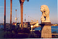
, ClearwaterClearwater, FloridaClearwater is a city located in Pinellas County, Florida, US, nearly due west of Tampa and northwest of St. Petersburg. In the west of Clearwater lies the Gulf of Mexico and in the east lies Tampa Bay. As of the 2000 census, the city had a total population of 108,787. It is the county seat of... - Bridge of LionsBridge of LionsThe Bridge of Lions is a bascule bridge that spans the Intracoastal Waterway in St. Augustine, Florida. A part of State Road A1A, it connects downtown St. Augustine to Anastasia Island. A pair of Medici lions made of marble guard the bridge, begun in 1925 and completed in 1927 across Matanzas Bay...
, St. AugustineSt. Augustine, FloridaSt. Augustine is a city in the northeast section of Florida and the county seat of St. Johns County, Florida, United States. Founded in 1565 by Spanish explorer and admiral Pedro Menéndez de Avilés, it is the oldest continuously occupied European-established city and port in the continental United... - Broadway BridgeBroadway Bridge (Daytona Beach)The Broadway Bridge is a segmental bridge that spans the Halifax River and Intracoastal Waterway in downtown Daytona Beach, Florida, carrying U.S. Route 92....
, Daytona BeachDaytona Beach, FloridaDaytona Beach is a city in Volusia County, Florida, USA. According to 2008 U.S. Census Bureau estimates, the city has a population of 64,211. Daytona Beach is a principal city of the Deltona – Daytona Beach – Ormond Beach, Florida Metropolitan Statistical Area, which the census bureau estimated had... - Buckman Bridge, JacksonvilleJacksonville, FloridaJacksonville is the largest city in the U.S. state of Florida in terms of both population and land area, and the largest city by area in the contiguous United States. It is the county seat of Duval County, with which the city government consolidated in 1968...
- Caloosahatchee BridgeCaloosahatchee BridgeThe Caloosahatchee Bridge is a bridge located in Fort Myers, Florida. It carries U.S. 41 over the Caloosahatchee River, which is where its name comes from. The Bridge has four lanes and is 55 feet tall.The Caloosahatchee Bridge opened in 1962, changing the routing of U.S...
, Fort MyersFort Myers, FloridaFort Myers is the county seat and commercial center of Lee County, Florida, United States. Its population was 62,298 in the 2010 census, a 29.23 percent increase over the 2000 figure.... - Cape Coral BridgeCape Coral BridgeThe Cape Coral Bridge is a bridge located in Southwest Florida. It spans the Caloosahatchee River connecting Fort Myers and Cape Coral. It is made up of two parallel fixed spans, each long....
, Fort MyersFort Myers, FloridaFort Myers is the county seat and commercial center of Lee County, Florida, United States. Its population was 62,298 in the 2010 census, a 29.23 percent increase over the 2000 figure....
to Cape CoralCape Coral, FloridaCape Coral is a municipality located in Lee County, Florida, United States, on the Gulf of Mexico. Founded in 1957 and developed as a master-planned, pre-platted community, the city grew to a population of 154,305 by the year 2010. With an area of , Cape Coral is the largest city between Tampa and... - Clearwater Memorial CausewayClearwater Memorial CausewayThe Clearwater Memorial Causeway is a four-lane road between downtown Clearwater and Clearwater Beach, Florida, and includes a fixed-span bridge across the Intracoastal Waterway...
, ClearwaterClearwater, FloridaClearwater is a city located in Pinellas County, Florida, US, nearly due west of Tampa and northwest of St. Petersburg. In the west of Clearwater lies the Gulf of Mexico and in the east lies Tampa Bay. As of the 2000 census, the city had a total population of 108,787. It is the county seat of... - Courtney Campbell Causeway, ClearwaterClearwater, FloridaClearwater is a city located in Pinellas County, Florida, US, nearly due west of Tampa and northwest of St. Petersburg. In the west of Clearwater lies the Gulf of Mexico and in the east lies Tampa Bay. As of the 2000 census, the city had a total population of 108,787. It is the county seat of...
to TampaTampa, FloridaTampa is a city in the U.S. state of Florida. It serves as the county seat for Hillsborough County. Tampa is located on the west coast of Florida. The population of Tampa in 2010 was 335,709.... - Dames Point BridgeDames Point BridgeThe Dames Point Bridge is a cable-stayed bridge over the St. Johns River in Jacksonville, Florida on State Road 9A. Construction began in 1985 and it was completed in 1989. The main span is 1300 feet, and is 175 feet high...
, JacksonvilleJacksonville, FloridaJacksonville is the largest city in the U.S. state of Florida in terms of both population and land area, and the largest city by area in the contiguous United States. It is the county seat of Duval County, with which the city government consolidated in 1968... - Eau Gallie CausewayEau Gallie CausewayThe Eau Gallie Causeway connects Eau Gallie, Florida , with SR A1A near Indian Harbour Beach, across the Indian River Lagoon. Located entirely within the Melbourne city limits, the causeway consists of a main bridge crossing over the Intracoastal Waterway and a relief bridge...
, MelbourneMelbourne, FloridaMelbourne is a city in Brevard County, Florida, United States. As of 2009, the population estimated by the U.S. Census Bureau is 78,323. The municipal area is the second largest by size and by population in the county. Melbourne is a principal city of the Palm Bay – Melbourne – Titusville, Florida... - Escambia Bay BridgeEscambia Bay BridgeThe Escambia Bay Bridge is a six-lane freeway bridge that carries Interstate 10 across Escambia Bay near Pensacola, Florida.-History:The original four-lane bridge opened in 1968...
, PensacolaPensacola, FloridaPensacola is the westernmost city in the Florida Panhandle and the county seat of Escambia County, Florida, United States of America. As of the 2000 census, the city had a total population of 56,255 and as of 2009, the estimated population was 53,752... - Fuller Warren Bridge, JacksonvilleJacksonville, FloridaJacksonville is the largest city in the U.S. state of Florida in terms of both population and land area, and the largest city by area in the contiguous United States. It is the county seat of Duval County, with which the city government consolidated in 1968...
- Gandy BridgeGandy BridgeGandy Bridge is the southernmost bridge spanning Old Tampa Bay from St. Petersburg, Florida to Tampa, Florida. Almost three miles long, it is one of three bridges connecting Hillsborough County and Pinellas County; the others being the Howard Frankland Bridge and the Courtney Campbell...
, St. PetersburgSt. Petersburg, FloridaSt. Petersburg is a city in Pinellas County, Florida, United States. It is known as a vacation destination for both American and foreign tourists. As of 2008, the population estimate by the U.S. Census Bureau is 245,314, making St...
to TampaTampa, FloridaTampa is a city in the U.S. state of Florida. It serves as the county seat for Hillsborough County. Tampa is located on the west coast of Florida. The population of Tampa in 2010 was 335,709.... - Hal W. Adams BridgeHal W. Adams BridgeThe Hal W. Adams Bridge, built in 1947, is an historic bridge that carries Florida State Road 51 across the Suwannee River between Lafayette and Suwannee counties, Florida. Located 3 miles north of Mayo, it was the first suspension bridge built in Florida, and the only one to carry highway traffic....
, Suwannee RiverSuwannee RiverThe Suwannee River is a major river of southern Georgia and northern Florida in the United States. It is a wild blackwater river, about long. The Suwannee River is the site of the prehistoric Suwannee Straits which separated peninsular Florida from the panhandle.-Geography:The river rises in the...
between LafayetteLafayette County, FloridaLafayette County is a county located in the state of Florida. As of 2000, the population was 7,022. It is the second least populated county in the state, having one more resident, according to the 2000 census, than Liberty County, Florida. The U.S. Census Bureau 2005 estimate for the county is...
and SuwanneeSuwannee County, FloridaSuwannee County is a county located in the state of Florida. As of 2000, the population was 34,844. The U.S. Census Bureau 2005 estimate for the county was 38,624 . Its county seat is Live Oak, Florida. Suwannee County was a dry county until August, 2011.....
counties, Florida'a first suspension bridgeSuspension bridgeA suspension bridge is a type of bridge in which the deck is hung below suspension cables on vertical suspenders. Outside Tibet and Bhutan, where the first examples of this type of bridge were built in the 15th century, this type of bridge dates from the early 19th century... - Hart BridgeHart BridgeThe Isaiah David Hart Bridge is a truss bridge that spans the St. Johns River in Jacksonville, Florida. It is named after Isaiah Hart, the founder of Jacksonville. It was designed by Sverdrup & Parcel.-Details:...
, JacksonvilleJacksonville, FloridaJacksonville is the largest city in the U.S. state of Florida in terms of both population and land area, and the largest city by area in the contiguous United States. It is the county seat of Duval County, with which the city government consolidated in 1968... - Howard Frankland BridgeHoward Frankland BridgeThe W. Howard Frankland Bridge is the central bridge spanning Old Tampa Bay from St. Petersburg, Florida to Tampa, Florida. It is one of three bridges connecting Hillsborough County and Pinellas County; the others being Gandy Bridge and Courtney Campbell Causeway...
, TampaTampa, FloridaTampa is a city in the U.S. state of Florida. It serves as the county seat for Hillsborough County. Tampa is located on the west coast of Florida. The population of Tampa in 2010 was 335,709.... - Julia Tuttle Causeway, Miami BeachMiami Beach, FloridaMiami Beach is a coastal resort city in Miami-Dade County, Florida, United States, incorporated on March 26, 1915. The municipality is located on a barrier island between the Atlantic Ocean and Biscayne Bay, the latter which separates the Beach from Miami city proper...
- Knox Memorial BridgeKnox Memorial BridgeThe Knox Memorial Bridge crosses the Intracoastal Waterway north of Ormond Beach, Florida. Highbridge Road passes over the bridge.-History:...
, Volusia CountyVolusia County, FloridaVolusia County is a county located in the state of Florida. The U.S. Census Bureau 2010 official county's population was 494,593 . Its county seat is DeLand, and its most populous city is currently Deltona.... - MacArthur CausewayMacArthur CausewayThe General Douglas MacArthur Causeway is a six-lane causeway which connects Downtown, Miami, Florida and South Beach, Miami Beach via Biscayne Bay....
, Miami Beach - Main Street BridgeMain Street Bridge (Jacksonville)The Main Street Bridge, officially the John T. Alsop Jr. Bridge, is a bridge crossing the St. Johns River in Jacksonville, Florida. It was the second bridge built across the river. It carries four lanes of traffic, and is signed as U.S. Route 1/US 90 . A lift bridge, it opened in July 1941 at a...
, JacksonvilleJacksonville, FloridaJacksonville is the largest city in the U.S. state of Florida in terms of both population and land area, and the largest city by area in the contiguous United States. It is the county seat of Duval County, with which the city government consolidated in 1968... - Mathews BridgeMathews BridgeThe Mathews Bridge is a truss bridge in Jacksonville, Florida, which spans the St. Johns River. Constructed in 1953, the bridge brings traffic along the Arlington Expressway between downtown Jacksonville and the Arlington neighborhood. It was named after John E...
, JacksonvilleJacksonville, FloridaJacksonville is the largest city in the U.S. state of Florida in terms of both population and land area, and the largest city by area in the contiguous United States. It is the county seat of Duval County, with which the city government consolidated in 1968... - Melbourne CausewayMelbourne CausewayThe Melbourne Causeway is located entirely within Brevard County, Florida in the United States. It is composed of three bridges and connects the municipalities of Melbourne, Florida and Indialantic, Florida across the Indian River Lagoon in Brevard County. The causeway is part of U.S...
, MelbourneMelbourne, FloridaMelbourne is a city in Brevard County, Florida, United States. As of 2009, the population estimated by the U.S. Census Bureau is 78,323. The municipal area is the second largest by size and by population in the county. Melbourne is a principal city of the Palm Bay – Melbourne – Titusville, Florida...
to IndialanticIndialantic, FloridaIndialantic is a town in Brevard County, Florida, United States. The name is a portmanteau derived from the town's location between the Indian River Lagoon and the Atlantic Ocean.... - Merrill P. Barber BridgeMerrill P. Barber BridgeThe Merrill P. Barber Bridge is a concrete arch bridge that spans the Indian River intercostals waterway in Indian River County, Florida. The bridge was built by Odebrecht Contractors of Florida, Inc. and was completed in 1995. A fishing pier is constructed below the bridge on the east side.The...
, Vero BeachVero Beach, FloridaVero Beach is a city in Indian River County, Florida, USA. According to the U.S. Census Bureau's 2006 estimates, the city had a population of 16,939. It is the county seat of Indian River County... - Mid-Bay Bridge, Choctawhatchee BayChoctawhatchee BayChoctawhatchee Bay is a bay in the Emerald Coast region of the Florida Panhandle. The bay, located within Okaloosa and Walton counties, has a surface area of 129 mi2...
, DestinDestin, FloridaDestin is a city located in Okaloosa County, Florida. It is a principal city of the Fort Walton Beach-Crestview-Destin, Florida Metropolitan Statistical Area.Located on Florida's Emerald Coast, Destin is known for its white beaches and emerald green waters...
to NicevilleNiceville, FloridaNiceville is a city in Okaloosa County, Florida, United States, located close to Eglin Air Force Base. It originally began with the name Valparaiso, then to separate itself from the neighboring town took the unofficial name of Boggy. Upon incorporation as an official city, the name was changed to... - Midpoint Memorial BridgeMidpoint Memorial BridgeThe Midpoint Memorial Bridge is a bridge located in Southwest Florida. It spans the Caloosahatchee River, connecting Fort Myers and Cape Coral. It is a four-lane fixed span one and one-quarter mile long...
, Lee CountyLee County, FloridaLee County is a county located in the U.S. state of Florida. Located in southwest Florida, the principal cities in the county are Fort Myers and Cape Coral... - Overseas HighwayOverseas HighwayThe Overseas Highway is a highway carrying U.S. Route 1 through the Florida Keys. Large parts of it were built on the former right-of-way of the Overseas Railroad, the Key West Extension of the Florida East Coast Railway. Completed in 1912, the Overseas Railroad was heavily damaged and partially...
, Florida KeysFlorida KeysThe Florida Keys are a coral archipelago in southeast United States. They begin at the southeastern tip of the Florida peninsula, about south of Miami, and extend in a gentle arc south-southwest and then westward to Key West, the westernmost of the inhabited islands, and on to the uninhabited Dry... - Pensacola Bay BridgePensacola Bay BridgeThe Pensacola Bay Bridge, also known locally as the Three-Mile Bridge, runs between downtown Pensacola, Florida, and Gulf Breeze, Florida. It carries four lanes of U.S. Highway 98 across Pensacola Bay.-History:...
, PensacolaPensacola, FloridaPensacola is the westernmost city in the Florida Panhandle and the county seat of Escambia County, Florida, United States of America. As of the 2000 census, the city had a total population of 56,255 and as of 2009, the estimated population was 53,752...
to Gulf BreezeGulf Breeze, FloridaGulf Breeze is a city located on the Fairpoint Peninsula in Santa Rosa County, Florida, United States and is a suburb of Pensacola which lies to the north, across Pensacola Bay. The population was 5,665 at the 2000 census. As of 2005, the population estimated by the U.S. Census Bureau is 6,455. ... - Rickenbacker CausewayRickenbacker CausewayThe Rickenbacker Causeway connects Miami, Florida, United States to the barrier islands of Virginia Key and Key Biscayne across Biscayne Bay.-Background:...
, Key BiscayneKey BiscayneKey Biscayne is an island located in Miami-Dade County, Florida, United States, between the Atlantic Ocean and Biscayne Bay. It is the southernmost of the barrier islands along the Atlantic coast of Florida, and lies south of Miami Beach and southeast of Miami... - Roosevelt Bridge, StuartStuart, FloridaStuart is the only incorporated city of Martin County, Florida, on Florida's Treasure Coast. The population was 14,633 at the 2000 census. As of 2007, the population recorded by the U.S. Census Bureau is 15,964....
- Sanibel CausewaySanibel CausewayThe Sanibel Causeway is a causeway in Southwest Florida that spans the San Carlos Bay, connecting Sanibel Island with the Florida mainland in South Fort Myers. The causeway consists of three separate two-lane bridge spans, and two man-made causeway islands, which are located between each of the...
, Lee CountyLee County, FloridaLee County is a county located in the U.S. state of Florida. Located in southwest Florida, the principal cities in the county are Fort Myers and Cape Coral... - Sebastian Inlet BridgeSebastian Inlet BridgeThe Sebastian Inlet Bridge is a high concrete arch bridge. It spans the Indian River outlet which is also referred to as the Sebastian Inlet. It connects State Road A1A in Indian River County, Florida to State Road A1A in Brevard County, Florida....
, Indian River CountyIndian River County, FloridaIndian River County is a county located in the Treasure Coast region in the U.S. state of Florida. As of 2000, the population was 112,947. The U.S. Census Bureau 2005 estimate for the county is 128,594... - Seven Mile BridgeSeven Mile BridgeThe Seven Mile Bridge is a famous bridge in the Florida Keys, in Monroe County, Florida, United States. It connects Knight's Key in the Middle Keys to Little Duck Key in the Lower Keys...
, Florida KeysFlorida KeysThe Florida Keys are a coral archipelago in southeast United States. They begin at the southeastern tip of the Florida peninsula, about south of Miami, and extend in a gentle arc south-southwest and then westward to Key West, the westernmost of the inhabited islands, and on to the uninhabited Dry... - Shands BridgeShands BridgeThe Shands Bridge is a highway bridge over the St. Johns River near Jacksonville, Florida. The span was first opened in 1929. It was located just north of the current span, crossing from Orangedale to the present Shands pier on the west side of the river....
, Green Cove SpringsGreen Cove Springs, FloridaGreen Cove Springs is a city in Clay County, Florida, United States. The population was 5,378 at the 2000 census. As of 2010, the population recorded by the U.S. Census Bureau is 6,908. It is the county seat of Clay County.... - St. George Island BridgeSt. George Island BridgeThe 4 mile St. George Island Bridge was built in 2002 when the two original bridges that led to St. George Island, a small resort town from Apalachicola, Florida were deemed unsafe due to their old age...
, Franklin CountyFranklin County, FloridaFranklin County is a coastal county located in the panhandle of the U.S. state of Florida. As of 2000, the population was 11,057. The U.S. Census Bureau 2005 estimate for the county is 11,177... - St. Johns River Veterans Memorial BridgeSt. Johns River Veterans Memorial BridgeThe original St. Johns River Bridge was a four-lane concrete-and-steel causeway bridge constructed over the St. Johns River at the west outlet of Lake Monroe. It is a part of Interstate 4, and spans the border between Seminole and Volusia Counties in Florida, United States...
, SanfordSanford, FloridaSanford is a city in, and the county seat of, Seminole County, Florida, United States. The population was 38,291 at the 2000 census. As of 2009, the population recorded by the U.S. Census Bureau was 50,998... - Sunshine Skyway BridgeSunshine Skyway BridgeThe Bob Graham Sunshine Skyway Bridge is a bridge spanning Tampa Bay, Florida, with a cable-stayed main span, and a total length of 21,877 feet . It is part of I-275 and US 19 , connecting St. Petersburg in Pinellas County and Terra Ceia in Manatee County, Florida, passing through Hillsborough...
, St. PetersburgSt. Petersburg, FloridaSt. Petersburg is a city in Pinellas County, Florida, United States. It is known as a vacation destination for both American and foreign tourists. As of 2008, the population estimate by the U.S. Census Bureau is 245,314, making St...
to BradentonBradenton, FloridaBradenton is a city in Manatee County, Florida, United States. The U.S. Census Bureau estimated the city's 2007 population to be 53,471. Bradenton is the largest Principal City of the Bradenton-Sarasota-Venice, Florida Metropolitan Statistical Area, which had a 2007 estimated population of 682,833... - Treasure Island CausewayTreasure Island CausewayTreasure Island Causeway, part of County Road 150, is a series of three bridges crossing Boca Ciega Bay between Treasure Island and St. Petersburg in Pinellas County, Florida...
, Treasure IslandTreasure Island, FloridaTreasure Island is a city in Pinellas County, Florida, in the United States. As of the 2000 census, the city population was 7,450. According to the U.S. Census Bureau's 2004 estimates, the city had a population of 7,521.-Geography:...
to St. PetersburgSt. Petersburg, FloridaSt. Petersburg is a city in Pinellas County, Florida, United States. It is known as a vacation destination for both American and foreign tourists. As of 2008, the population estimate by the U.S. Census Bureau is 245,314, making St... - Venetian CausewayVenetian CausewayThe Venetian Causeway crosses Biscayne Bay between Miami on the mainland and Miami Beach on a barrier island in south Florida. The man-made Venetian Islands and non-bridge portions of the causeway were created by materials which came from the dredging of the bay. The Venetian Causeway follows the...
, Miami BeachMiami Beach, FloridaMiami Beach is a coastal resort city in Miami-Dade County, Florida, United States, incorporated on March 26, 1915. The municipality is located on a barrier island between the Atlantic Ocean and Biscayne Bay, the latter which separates the Beach from Miami city proper... - Wabasso BridgeWabasso BridgeThe Wabasso Causeway Bridge is a concrete arch bridge spanning the Indian River in Indian River County, Florida. The bridge was built by Scott Construction Company and was completed in 1970....
, WabassoWabasso, FloridaWabasso is a census-designated place in Indian River County, Florida, United States. The population was 918 at the 2000 census. It is located on the intersections of CR 605, U.S...
See also
- List of crossings of the Aucilla River
- List of crossings of the Halifax River
- List of crossings of the St. Johns River
- List of crossings of the Ochlockonee River
- List of crossings of the Suwannee River
- Waterways forming and crossings of the Atlantic Intracoastal Waterway
- Waterways forming and crossings of the Gulf Intracoastal Waterway
Georgia
- Bethany BridgeBethany BridgeBethany Bridge is a green truss bridge that crosses the Allatoona Creek arm of Lake Allatoona, just south of where it meets the Etowah River arm. The bridge carries Red Top Mountain Road, and connects Red Top Mountain State Park to nearby Interstate 75 and U.S. 41...
, EmersonEmerson, GeorgiaEmerson is a city in far southern Bartow County, Georgia, United States, on highways 41, 293, and 75. The population was 1,092 at the 2000 census.... - Butt Memorial BridgeButt Memorial BridgeThe Butt Memorial Bridge is a road bridge in Augusta, Georgia dedicated to Major Archibald Willingham Butt, a victim of the sinking of the RMS Titanic. The bridge was erected in 1914 and dedicated by President William Howard Taft, a personal friend of Butt's...
, AugustaAugusta, GeorgiaAugusta is a consolidated city in the U.S. state of Georgia, located along the Savannah River. As of the 2010 census, the Augusta–Richmond County population was 195,844 not counting the unconsolidated cities of Hephzibah and Blythe.Augusta is the principal city of the Augusta-Richmond County... - Euharlee Covered BridgeEuharlee Covered BridgeThe Euharlee Covered Bridge, also known as the Euharlee Creek Covered Bridge or rarely the Lowry Bridge, is a wooden covered bridge crossing Euharlee Creek in Euharlee, Georgia, a small town west of Cartersville. The bridge was built after the raging creek swept away an old bridge on the property...
, EuharleeEuharlee, GeorgiaEuharlee is a city in Bartow County, Georgia, United States. The population was 3,208 at the 2000 census. The city's explosive growth is evident as of the 2005 census the city's population rose to 3,859, and for 2006 estimates, Euharlee showed a population of 4,059... - James P. Houlihan Memorial Bridge, SavannahSavannah, GeorgiaSavannah is the largest city and the county seat of Chatham County, in the U.S. state of Georgia. Established in 1733, the city of Savannah was the colonial capital of the Province of Georgia and later the first state capital of Georgia. Today Savannah is an industrial center and an important...
- Sidney Lanier BridgeSidney Lanier BridgeThe Sidney Lanier Bridge is a cable-stayed bridge that spans the Brunswick River in Brunswick, Georgia, carrying four lanes of U.S. Route 17. The current bridge was built as a replacement to the original lift bridge which was twice struck by ships. It is currently the longest spanning bridge in...
, BrunswickBrunswick, GeorgiaBrunswick is the major urban and economic center in southeastern Georgia in the United States. The municipality is located on a harbor near the Atlantic Ocean, approximately 30 miles north of Florida and 70 miles south of South Carolina. Brunswick is bordered on the east by the Atlantic... - Talmadge Memorial BridgeTalmadge Memorial BridgeThe Talmadge Memorial Bridge is a bridge in the United States that spans the Savannah River between downtown Savannah, Georgia, and Hutchinson Island.-History:...
, SavannahSavannah, GeorgiaSavannah is the largest city and the county seat of Chatham County, in the U.S. state of Georgia. Established in 1733, the city of Savannah was the colonial capital of the Province of Georgia and later the first state capital of Georgia. Today Savannah is an industrial center and an important...
Hawaii
- Hale'iwa Bridge, OahuOahuOahu or Oahu , known as "The Gathering Place", is the third largest of the Hawaiian Islands and most populous of the islands in the U.S. state of Hawaii. The state capital Honolulu is located on the southeast coast...
- Pu'u'opae BridgePu'u'opae BridgeThe Puuōpae Bridge is a one-lane, single-span, concrete-encased steel bridge across Kalama Stream located along Puuōpae Road between Kalama and Kīpapa Roads in the Wailua Homesteads area near Kapaa in Kauai, Hawaii, United States...
Illinois
- Abraham Lincoln Memorial Bridge, LaSalle/PeruPeru, IllinoisPeru is a city in LaSalle County, Illinois, United States. The population was 10,295 at the 2010 census. It is part of the Ottawa–Streator Micropolitan Statistical Area...
- Bob Michel BridgeBob Michel BridgeThe Bob Michel Bridge carries Illinois Route 40 over the Illinois River just .75 miles up-river from the Cedar Street Bridge. Illinois 40 terminates at an interchange with Interstate 74 just east of the bridge. The bridge serves as a direct surface route from a major commercial center...
, PeoriaPeoria, IllinoisPeoria is the largest city on the Illinois River and the county seat of Peoria County, Illinois, in the United States. It is named after the Peoria tribe. As of the 2010 census, the city was the seventh-most populated in Illinois, with a population of 115,007, and is the third-most populated... - Cedar Street BridgeCedar Street BridgeThe Cedar Street Bridge carries Illinois Route 8, Illinois Route 29, and Illinois Route 116 over the Illinois River. It is about a mile and a half southwest from downtown. The bridge is a simple steel arch bridge that towers approximately 70 to above the surface of the river, and is the shortest...
, Peoria - Chicago Skyway 'High Bridge'Chicago SkywayThe Chicago Skyway, also known as Chicago Skyway Toll Bridge System, is a toll road in Chicago, Illinois, United States, carrying Interstate 90 from the Indiana Toll Road to the Dan Ryan Expressway on Chicago's South Side leading into the Chicago Loop....
, ChicagoChicagoChicago is the largest city in the US state of Illinois. With nearly 2.7 million residents, it is the most populous city in the Midwestern United States and the third most populous in the US, after New York City and Los Angeles... - Clark BridgeClark BridgeThe Clark Bridge is a cable-stayed bridge across the Mississippi River between West Alton, Missouri and Alton, Illinois. Named after explorer William Clark like the bridge it replaced, the cable-stayed bridge opened in 1994. It carries U.S. Route 67 across the river...
, AltonAlton, IllinoisAlton is a city on the Mississippi River in Madison County, Illinois, United States, about north of St. Louis, Missouri. The population was 27,865 at the 2010 census. It is a part of the Metro-East region of the Greater St. Louis metropolitan area in Southern Illinois... - Cortland Street DrawbridgeCortland Street DrawbridgeThe Cortland Street Drawbridge over the Chicago River is the original Chicago-style fixed-trunnion bascule bridge, designed by John Ericson and Edward Wilmann. When it opened in 1902 on the north side of Chicago, it was the first such bridge built in the United States...
, ChicagoChicagoChicago is the largest city in the US state of Illinois. With nearly 2.7 million residents, it is the most populous city in the Midwestern United States and the third most populous in the US, after New York City and Los Angeles... - Dearborn Street BridgeDearborn Street BridgeThe Dearborn Street Bridge over the Chicago River was built in 1962. It connects the Near North Side with "The Loop." The American Institute of Steel Construction honored the bridge with the 1963 "Most Beautiful Steel Bridge" award in the Movable Span category....
, ChicagoChicagoChicago is the largest city in the US state of Illinois. With nearly 2.7 million residents, it is the most populous city in the Midwestern United States and the third most populous in the US, after New York City and Los Angeles... - John T. McNaughton Bridge, PekinPekin, IllinoisPekin is a the county seat of Tazewell County in the U.S. state of Illinois. Located on the Illinois River, Pekin is also the largest city of Tazewell County, and a key part of the Peoria metropolitan area. As of the 2010 census, its population is 34,094. A small portion of the city limits extends...
- Lyndon BridgeLyndon BridgeThe Lyndon Bridge is a metal Parker Pratt through-truss bridge in the village of Lyndon, Whiteside County, Illinois, United States. The Lyndon Bridge was designed by engineer R.S. Riser and completed in 1894 for around $20,000. Whiteside County maintained the bridge from its construction until it...
, LyndonLyndon, IllinoisLyndon is a village in Whiteside County, Illinois, United States. The population was 648 at the 2010 census, up from 566 at the 2000 census.-Geography:Lyndon is located at .... - McClugage Bridge (Ironworkers' Memorial Bridge), Peoria
- Murray Baker BridgeMurray Baker BridgeThe Murray Baker Bridge is a landmark cantilever bridge that carries Interstate 74 over the Illinois River from downtown Peoria to East Peoria in central Illinois...
, Peoria - North Avenue BridgeNorth Avenue BridgeThe North Avenue Bridge can refer to one of three bridges that has carried North Avenue over the North Branch of the Chicago River on the north side of Chicago, Illinois...
, ChicagoChicagoChicago is the largest city in the US state of Illinois. With nearly 2.7 million residents, it is the most populous city in the Midwestern United States and the third most populous in the US, after New York City and Los Angeles... - Ruby Street Bridge, JolietJoliet, IllinoisJoliet is a city in Will and Kendall Counties in the U.S. state of Illinois, located southwest of Chicago. It is the county seat of Will County. As of the 2010 census, the city was the fourth-most populated in Illinois, with a population of 147,433. It continues to be Illinois' fastest growing...
- Shade-Lohmann Bridge, Peoria
Indiana
- Cataract falls Covered Bridge, Owen county, IndianaOwen County, IndianaOwen County is a county located in the U.S. state of Indiana, and determined by the U.S. Census Bureau to include the mean center of U.S. population in 1920. As of 2010, the population was 21,575...
, listed on the National Register - Glover Cary BridgeGlover Cary BridgeThe Glover H. Cary Bridge is a continuous truss bridge that spans the Ohio River between Owensboro, Kentucky and Spencer County, Indiana. It was named for the late U.S. Congressman Glover H. Cary , and opened to traffic in September 1940...
, Spencer CountySpencer County, IndianaAs of the census of 2000, there were 20,391 people, 7,569 households, and 5,752 families residing in the county. The population density was 51 people per square mile . There were 8,333 housing units at an average density of 21 per square mile...
to Owensboro, KentuckyOwensboro, KentuckyOwensboro is the fourth largest city by population in the U.S. state of Kentucky. It is the county seat of Daviess County. It is located on U.S. Route 60 about southeast of Evansville, Indiana, and is the principal city of the Owensboro, Kentucky, Metropolitan Statistical Area. The city's... - John F. Kennedy Memorial BridgeJohn F. Kennedy Memorial BridgeThe John F. Kennedy Memorial Bridge is a seven-lane, single-deck cantilever bridge that carries Interstate 65 across the Ohio River, connecting Louisville, Kentucky and Jeffersonville, Indiana. The main span is and the bridge has a total length of...
, JeffersonvilleJeffersonville, IndianaJeffersonville is a city in Clark County, Indiana, along the Ohio River. Locally, the city is often referred to by the abbreviated name Jeff. It is directly across the Ohio River to the north of Louisville, Kentucky along I-65. The population was 44,953 at the 2010 census...
to Louisville, KentuckyLouisville, KentuckyLouisville is the largest city in the U.S. state of Kentucky, and the county seat of Jefferson County. Since 2003, the city's borders have been coterminous with those of the county because of a city-county merger. The city's population at the 2010 census was 741,096... - Laughery Creek BridgeLaughery Creek BridgeThe Laughery Creek Bridge is an abandoned truss bridge on the border of Dearborn County, Indiana and Ohio County, Indiana. It crosses Laughery Creek. This bridge was built in 1878. The Wrought Iron Bridge Company, a prolific late 19th century bridge company, constructed the bridge. The bridge is...
, Dearborn CountyDearborn County, IndianaDearborn County is a county located in the U.S. state of Indiana. As of 2010, the population was 50,047. It is part of the Cincinnati-Northern Kentucky metropolitan area. The county seat is Lawrenceburg.-History:...
; only known example of a Triple Whipple TrussTriple Whipple TrussThe triple whipple truss is a style of bridge design that was used in the 19th century. The only remaining example of this style in the United States is the Laughery Creek Bridge in Indiana....
bridge in the world - Lincoln Memorial Bridge, downtown VincennesVincennes, IndianaVincennes is a city in and the county seat of Knox County, Indiana, United States. It is located on the Wabash River in the southwestern part of the state. The population was 18,701 at the 2000 census...
to IllinoisIllinoisIllinois is the fifth-most populous state of the United States of America, and is often noted for being a microcosm of the entire country. With Chicago in the northeast, small industrial cities and great agricultural productivity in central and northern Illinois, and natural resources like coal,...
(old US 50U.S. Route 50U.S. Route 50 is a major east–west route of the U.S. Highway system, stretching just over from Ocean City, Maryland on the Atlantic Ocean to West Sacramento, California. Until 1972, when it was replaced by Interstate Highways west of the Sacramento area, it extended to San Francisco, near...
) - Parke County Covered BridgesParke County Covered BridgesThe covered bridges of Parke County are well-known tourist attractions in Parke County, Indiana, United States, which touts itself as the "Covered Bridge Capital of the World". The county has more covered bridges than any other county in the United States...
- Sherman Minton BridgeSherman Minton BridgeThe Sherman Minton Bridge is a double-deck through arch bridge spanning the Ohio River, carrying I-64 and US 150 over the river between Kentucky and Indiana. The bridge connects the west side of Louisville, Kentucky to downtown New Albany, Indiana.- History :...
, New AlbanyNew Albany, IndianaNew Albany is a city in Floyd County, Indiana, United States, situated along the Ohio River opposite Louisville, Kentucky. In 1900, 20,628 people lived in New Albany; in 1910, 20,629; in 1920, 22,992; and in 1940, 25,414. The population was 36,372 at the 2010 census. The city is the county seat of...
to Louisville, KentuckyLouisville, KentuckyLouisville is the largest city in the U.S. state of Kentucky, and the county seat of Jefferson County. Since 2003, the city's borders have been coterminous with those of the county because of a city-county merger. The city's population at the 2010 census was 741,096... - William H. Natcher BridgeWilliam H. Natcher BridgeThe William H. Natcher Bridge is a cable-stayed bridge that carries U.S. Highway 231 over the Ohio River. The bridge connects Owensboro, Kentucky to Rockport, Indiana and opened on October 21, 2002. It is named in honor of William Huston Natcher, a former United States Representative who served...
, RockportRockport, IndianaRockport is a city in Ohio Township, Spencer County, Indiana, along the Ohio River. The population was 2,160 at the 2000 census. The city is the county seat of Spencer County.-History:...
to Owensboro, KentuckyOwensboro, KentuckyOwensboro is the fourth largest city by population in the U.S. state of Kentucky. It is the county seat of Daviess County. It is located on U.S. Route 60 about southeast of Evansville, Indiana, and is the principal city of the Owensboro, Kentucky, Metropolitan Statistical Area. The city's... - Tulip ViaductTulip ViaductThe Tulip Viaduct is a long railroad bridge in Greene County, Indiana that spans Richland Creek between Solsberry and Tulip...
, Solsberry, IndianaSolsberry, IndianaSolsberry is an unincorporated town in Beech Creek Township, Greene County, Indiana.-Geography:Solsberry is located at ....
, longest railroad trestle in U.S.
Iowa
- Bellevue BridgeBellevue BridgeThe Bellevue Bridge is a truss bridge over the Missouri River connecting Mills County, Iowa and Sarpy County, Nebraska at Bellevue, Nebraska....
, connects Mills County, IowaMills County, Iowa-2010 census:The 2010 census recorded a population of 15,059 in the county, with a population density of . There were 6,109 housing units, of which 5,605 were occupied.-2000 census:...
and Sarpy County, NebraskaSarpy County, Nebraska-Demographics:As of the census of 2000, there were 122,595 people, 43,426 households, and 33,220 families residing in the county. The population density was 510 people per square mile . There were 44,981 housing units at an average density of 187 per square mile...
at Bellevue, NebraskaBellevue, NebraskaBellevue is a city in Sarpy County, Nebraska, United States. The population was 50,137 at the 2010 census. Eight miles south of Omaha, Bellevue is part of the Omaha-Council Bluffs metropolitan area. Originally settled in the 1830s, It was the first state capitol. Bellevue was incorporated in... - Black Hawk BridgeBlack Hawk BridgeThe Black Hawk Bridge spans the Mississippi River, joining the town of Lansing, in Allamakee County, Iowa, to rural Crawford County, Wisconsin. It is the northernmost Mississippi River bridge in Iowa....
, LansingLansing, IowaLansing is a city in Lansing Township, Allamakee County, Iowa, United States. The population was 1,012 at the 2000 census.-Geography:Lansing's longitude and latitude coordinatesin decimal form are 43.361525, -91.223378... - Crescent Rail BridgeCrescent Rail BridgeThe Crescent Rail Bridge carries a rail line across the Mississippi River between Davenport, Iowa and Rock Island, Illinois. It was formerly owned by the Davenport, Rock Island and North Western Railway, a joint subsidiary of the Chicago, Burlington and Quincy Railroad and Chicago, Milwaukee, St...
, connects Davenport, IowaDavenport, IowaDavenport is a city located along the Mississippi River in Scott County, Iowa, United States. Davenport is the county seat of and largest city in Scott County. Davenport was founded on May 14, 1836 by Antoine LeClaire and was named for his friend, George Davenport, a colonel during the Black Hawk...
to Rock Island, IllinoisRock Island, IllinoisRock Island is the county seat of Rock Island County, Illinois, United States. The population was 40,884 at the 2010 census. Located on the Mississippi River, it is one of the Quad Cities, along with neighboring Moline, East Moline, and the Iowa cities of Davenport and Bettendorf. The Quad Cities... - Davenport SkybridgeDavenport SkybridgeThe Davenport Skybridge is a pedestrian cable-stayed bridge that spans River Drive in downtown Davenport, Iowa. It connects LeClaire Park and Rhythm City Casino to a courtyard and parking ramp on 2nd Street, located right next to the River Music Experience. The bridge is 50 feet tall and 575 feet...
, DavenportDavenport, IowaDavenport is a city located along the Mississippi River in Scott County, Iowa, United States. Davenport is the county seat of and largest city in Scott County. Davenport was founded on May 14, 1836 by Antoine LeClaire and was named for his friend, George Davenport, a colonel during the Black Hawk... - Dubuque-Wisconsin BridgeDubuque-Wisconsin BridgeThe Dubuque–Wisconsin Bridge is a steel tied arch bridge connecting Dubuque, Iowa, with still largely rural Grant County, Wisconsin. It is an automobile bridge that traverses the Mississippi River. It is one of two automobile bridges in the Dubuque area. A railroad bridge is between them...
, connects Dubuque, IowaDubuque, IowaDubuque is a city in and the county seat of Dubuque County, Iowa, United States, located along the Mississippi River. In 2010 its population was 57,637, making it the ninth-largest city in the state and the county's population was 93,653....
to Grant County, WisconsinGrant County, WisconsinGrant County is a county located in the U.S. state of Wisconsin. As of 2000, the population was 49,597. Its county seat is Lancaster. Estimates for 2008 show a population of 49,238... - Fort Madison Toll Bridge, connects Fort Madison, IowaFort Madison, IowaFort Madison, situated on the Mississippi River, is a city in and one of the county seats of Lee County, Iowa, United States. The other county seat is Keokuk. The population was 10,715 at the 2000 census...
to Niota, IllinoisNiota, IllinoisNiota is an unincorporated community in Appanoose Township, Hancock County, Illinois. The community is located on the bank of the Mississippi River and is at the eastern end of the Fort Madison Toll Bridge, which connects Niota to Fort Madison, Iowa. Niota is the western terminus of Illinois Route... - Fred Schwengel Memorial BridgeFred Schwengel Memorial BridgeThe Fred Schwengel Memorial Bridge is a 4-lane steel girder bridge that carries Interstate 80 across the Mississippi River between LeClaire, Iowa and Rapids City, Illinois. The bridge is named for Fred Schwengel, a former U.S. Representative from Davenport, Iowa and one of the driving forces behind...
connects LeClaire, Iowa to Rapids City, IllinoisRapids City, IllinoisRapids City is a village in Rock Island County, Illinois, United States. The population was 953 at the 2000 census.-Geography:Rapids City is located at .... - Gateway BridgeGateway Bridge (Illinois-Iowa)The Gateway Bridge is a suspension bridge over the Mississippi River in Clinton, Iowa, USA. It carries U.S. Route 30 from Iowa into Illinois just south of Fulton, Illinois...
, connects Clinton, IowaClinton, IowaClinton is a city in and the county seat of Clinton County, Iowa, United States. The population was 26231as of 2010. Clinton, along with DeWitt, Iowa , was named in honor of the seventh governor of New York, DeWitt Clinton. Clinton is the principal city of the Clinton Micropolitan Statistical...
to Fulton, IllinoisFulton, IllinoisFulton is a city in Whiteside County, Illinois, United States. The population was 3,481 at the 2010 census, down from 3,881 at the 2000 census. Fulton is located across the Mississippi River from Clinton, Iowa.-Geography:... - Government Bridge, Davenport, IowaDavenport, IowaDavenport is a city located along the Mississippi River in Scott County, Iowa, United States. Davenport is the county seat of and largest city in Scott County. Davenport was founded on May 14, 1836 by Antoine LeClaire and was named for his friend, George Davenport, a colonel during the Black Hawk...
to Rock Island, IllinoisRock Island, IllinoisRock Island is the county seat of Rock Island County, Illinois, United States. The population was 40,884 at the 2010 census. Located on the Mississippi River, it is one of the Quad Cities, along with neighboring Moline, East Moline, and the Iowa cities of Davenport and Bettendorf. The Quad Cities... - Great River BridgeGreat River BridgeThe Great River Bridge is an asymmetrical, one-tower cable-stayed bridge over the Mississippi River. It carries U.S. Route 34 from Burlington, Iowa to the town of Gulf Port, Illinois.-History:...
, connects Burlington, IowaBurlington, IowaBurlington is a city in, and the county seat of Des Moines County, Iowa, United States. The population was 25,663 in the 2010 census, a decline from the 26,839 population in the 2000 census. Burlington is the center of a micropolitan area including West Burlington, Iowa and Middletown, Iowa and...
to Gulf Port, IllinoisGulf Port, IllinoisGulf Port is a village in Henderson County, Illinois, in the United States. As of the 2000 census, the village population was 207. It is part of the Burlington, IA–IL Micropolitan Statistical Area. The village was completely submerged, save the roofs of some homes and buildings, by a levee... - I-74 BridgeI-74 BridgeThe Interstate 74 Bridge, originally known as the Iowa-Illinois Memorial Bridge, and often called The Twin Bridges, or the I-74 Bridge, is a pair of suspension bridges that cross the Mississippi River and connect Bettendorf, Iowa and Moline, Illinois. It is located near the geographic center of...
, Bettendorf, IowaBettendorf, IowaBettendorf is a city in Scott County, Iowa, United States. Bettendorf is the fifteenth largest city in the U.S. state of Iowa and the fourth largest city in the "Quad Cities". As of the 2010 United States Census the population grew to 33,217. Bettendorf is one of the Quad Cities, along with...
to Moline, IllinoisMoline, IllinoisMoline is a city located in Rock Island County, Illinois, United States, with a population of 45,792 in 2010. Moline is one of the Quad Cities, along with neighboring East Moline and Rock Island in Illinois and the cities of Davenport and Bettendorf in Iowa. The Quad Cities has a population of... - Julien Dubuque BridgeJulien Dubuque BridgeThe Julien Dubuque Bridge traverses the Mississippi River. It joins the cities of Dubuque, Iowa, and East Dubuque, Illinois. The bridge is part of the U.S. Highway 20 route...
, connects Dubuque, IowaDubuque, IowaDubuque is a city in and the county seat of Dubuque County, Iowa, United States, located along the Mississippi River. In 2010 its population was 57,637, making it the ninth-largest city in the state and the county's population was 93,653....
to East Dubuque, IllinoisEast Dubuque, IllinoisEast Dubuque is a city in Jo Daviess County, Illinois, United States. The population was 1,704 at the 2010 census, down from 1,995 at the 2000 census. East Dubuque is located alongside the Mississippi River. Across the river is the city of Dubuque, Iowa. About three miles north of the city is the... - Keokuk-Hamilton BridgeKeokuk-Hamilton BridgeThe Keokuk-Hamilton bridge is a steel girder, 4-lane bridge from Keokuk, Iowa to Hamilton, Illinois. It carries U.S. Route 136 across the Mississippi River....
, connects Keokuk, IowaKeokuk, IowaKeokuk is a city in the southeastern part of the U.S. state of Iowa and one of the county seats of Lee County. The other county seat is Fort Madison. The population was 11,427 at the 2000 census. The city is named after the Sauk Chief Keokuk, who is thought to be buried in Rand Park...
to Hamilton, IllinoisHamilton, IllinoisHamilton is a city in Hancock County, Illinois, United States. The population was 3,029 at the 2000 census. The city is located directly across the Mississippi River from Keokuk, Iowa. Hamilton is the largest city in Hancock County.-About Hamilton:... - Lyons-Fulton BridgeLyons-Fulton BridgeThe Mark N. Morris Bridge is a 2 lane automobile truss bridge across the Mississippi River in the United States. It connects the cities of Clinton, Iowa and Fulton, Illinois....
, connects Clinton, IowaClinton, IowaClinton is a city in and the county seat of Clinton County, Iowa, United States. The population was 26231as of 2010. Clinton, along with DeWitt, Iowa , was named in honor of the seventh governor of New York, DeWitt Clinton. Clinton is the principal city of the Clinton Micropolitan Statistical...
to Fulton, IllinoisFulton, IllinoisFulton is a city in Whiteside County, Illinois, United States. The population was 3,481 at the 2010 census, down from 3,881 at the 2000 census. Fulton is located across the Mississippi River from Clinton, Iowa.-Geography:... - Marquette-Joliet BridgeMarquette-Joliet BridgeThe Marquette–Joliet Bridge is a bridge crossing the Mississippi River, connecting Marquette, Iowa and Prairie du Chien, Wisconsin. Local residents refer to the bridge as the Prairie Bridge or the Marquette Bridge; both terms are used equally....
, connects Marquette, IowaMarquette, IowaMarquette is a city in Clayton County, Iowa, United States. The population was 421 at the 2000 census. The city, which is located on the Mississippi River, is named after Jesuit missionary Jacques Marquette, who along with Louis Joliet discovered the Mississippi River just southeast of the city on...
to Prairie du Chien, WisconsinPrairie du Chien, WisconsinPrairie du Chien is a city in and the county seat of Crawford County, Wisconsin, United States. The population was 5,911 at the 2010 census. Its Zip Code is 53821.... - Nebraska City BridgeNebraska City BridgeThe Nebraska City Bridge is a four-lane girder bridge over the Missouri River connecting Otoe County, Nebraska with Fremont County, Iowa at Nebraska City, Nebraska....
, connects Otoe County, NebraskaOtoe County, Nebraska-History:Otoe County was formed in 1854. It was named after the Otoe Indian tribe.-Demographics:As of the census of 2000, there were 15,396 people, 6,060 households, and 4,229 families residing in the county. The population density was 25 people per square mile . There were 6,567 housing units...
with Fremont County, IowaFremont County, Iowa-2010 census:The 2010 census recorded a population of 7,441 in the county, with a population density of . There were 3,431 housing units, of which 3,064 were occupied.-2000 census:...
at Nebraska City, NebraskaNebraska City, NebraskaNebraska City is a city in Otoe County, Nebraska, United States. The population was 7,228 at the 2000 census. It is the county seat of Otoe County... - Norbert F. Beckey BridgeNorbert F. Beckey BridgeThe Norbert F. Beckey Bridge, or Beckey Bridge for short, carries Iowa Highway 92 and Illinois Route 92 across the Mississippi River between Muscatine, Iowa and Rock Island County, Illinois. Completed in December 1972, it replaced the Muscatine High Bridge which stood from 1891-1973...
, connects Muscatine, IowaMuscatine, IowaMuscatine is a city in Muscatine County, Iowa, United States. The population was 22,886 in the 2010 census, an increase from 22,697 in the 2000 census. It is the county seat of Muscatine County...
to Rock Island County, IllinoisRock Island County, IllinoisRock Island County is a county located in the U.S. state of Illinois. According to the 2010 census, it has a population of 147,546, which is a decrease of 1.2% from 149,374 in 2000. Its county seat is Rock Island... - Plattsmouth BridgePlattsmouth Bridge. At the time it was the only bridge that was still open crossing the river for more than 100 miles from Omaha to St. Joseph, Missouri]]The Plattsmouth Bridge is a truss bridge over the Missouri River connecting Cass County, Nebraska and Mills County, Iowa via U.S. Route 34...
, connects Cass County, NebraskaCass County, Nebraska-Other Geographical notes:Due to its proximity to Cass County, Iowa, and because both of those counties receive most of their broadcasts from Omaha, Nebraska, references to 'Cass County' must be frequently disambiguated, or result in confusion.-Demographics:...
to Mills County, IowaMills County, Iowa-2010 census:The 2010 census recorded a population of 15,059 in the county, with a population density of . There were 6,109 housing units, of which 5,605 were occupied.-2000 census:... - Rock Island Centennial BridgeRock Island Centennial BridgeThe Centennial Bridge, or Rock Island Centennial Bridge, connects Rock Island, Illinois and Davenport, Iowa. The bridge is long and stands above water level. On September 4, 1988, lights were installed on the arches, which make the bridge a very scenic sight at night.Construction of the bridge...
, connects Davenport, IowaDavenport, IowaDavenport is a city located along the Mississippi River in Scott County, Iowa, United States. Davenport is the county seat of and largest city in Scott County. Davenport was founded on May 14, 1836 by Antoine LeClaire and was named for his friend, George Davenport, a colonel during the Black Hawk...
to Rock Island, IllinoisRock Island, IllinoisRock Island is the county seat of Rock Island County, Illinois, United States. The population was 40,884 at the 2010 census. Located on the Mississippi River, it is one of the Quad Cities, along with neighboring Moline, East Moline, and the Iowa cities of Davenport and Bettendorf. The Quad Cities... - Savanna-Sabula BridgeSavanna-Sabula BridgeThe Savanna–Sabula Bridge is a truss bridge and causeway crossing the Mississippi River and connecting the city of Savanna, Illinois with the island city of Sabula, Iowa. The bridge carries U.S. Highway 52 over the river. It is also the terminus of both Iowa Highway 64 and Illinois Route 64...
, connects Savanna, IllinoisSavanna, IllinoisSavanna is a city in Carroll County, Illinois, United States. The population was 3,062 at the 2010 census, down from 3,542 at the 2000 census. Savanna is located along the Mississippi River at the mouth of the Plum River. Going from north to south, the second automobile bridge between Iowa and...
to Sabula, IowaSabula, IowaSabula is a city in Jackson County, Iowa, United States. The population was 670 at the 2000 census. Sabula is the site of Iowa's only island city. The island has a beach and a campground. It also has a harbor with boat docks and storage sheds to store some boats during the winter... - Siouxland Veterans Memorial BridgeSiouxland Veterans Memorial BridgeThe Siouxland Veterans Memorial Bridge is a through arch bridge which carries U.S. Route 77 across the Missouri River between Sioux City, Iowa and South Sioux City, Nebraska....
(formerly Combination Bridge), connects Sioux City, IowaSioux City, IowaSioux City is a city in Plymouth and Woodbury counties in the western part of the U.S. state of Iowa. The population was 82,684 in the 2010 census, a decline from 85,013 in the 2000 census, which makes it currently the fourth largest city in the state....
to South Sioux City, NebraskaSouth Sioux City, Nebraska-2000 Census:As of the census of 2000, there were 11,925 people, 4,304 households, and 2,961 families residing in the city. Of the 11,925 people, 48.6% are male and 51.4% are female. The population density was 2,431.6 people per square mile . There were 4,557 housing units at an average density of... - Union Pacific Missouri River BridgeUnion Pacific Missouri River BridgeThe Union Pacific Missouri River Bridge is a rail truss bridge across the Missouri River connecting Council Bluffs, Iowa with Omaha, Nebraska.-History:...
, connects Council Bluffs, IowaCouncil Bluffs, IowaCouncil Bluffs, known until 1852 as Kanesville, Iowathe historic starting point of the Mormon Trail and eventual northernmost anchor town of the other emigrant trailsis a city in and the county seat of Pottawattamie County, Iowa, United States and is on the east bank of the Missouri River across...
to Omaha, NebraskaOmaha, NebraskaOmaha is the largest city in the state of Nebraska, United States, and is the county seat of Douglas County. It is located in the Midwestern United States on the Missouri River, about 20 miles north of the mouth of the Platte River...
Kansas
- 12th Street Bridge12th Street BridgeThe 12th Street Bridge is an automobile crossing of the Kansas River in Kansas City, Kansas.The first bridge was built in 1909, as a one lane deck truss bridge, in 1921, the bridge was damaged in a fire, and replaced in 1930, as a two lane thru-truss....
, a girder bridge in Kansas CityKansas City, KansasKansas City is the third-largest city in the state of Kansas and is the county seat of Wyandotte County. It is a suburb of Kansas City, Missouri, and is the third largest city in the Kansas City Metropolitan Area. The city is part of a consolidated city-county government known as the "Unified... - 18th Street Expressway Bridge18th Street Expressway BridgeThe 18th Street Expressway Bridge is a one level deck truss, four lane crossing of the Kansas River in Kansas City, Kansas.It was built in 1959, to replace the Argentine Bridge to the west.It also rises above the BNSF railroad tracks....
, a one-level deck truss bridge over the Kansas RiverKansas RiverThe Kansas River is a river in northeastern Kansas in the United States. It is the southwestern-most part of the Missouri River drainage, which is in turn the northwestern-most portion of the extensive Mississippi River drainage. Its name come from the Kanza people who once inhabited the area...
in Kansas City - 23rd Street viaduct, a one-level, four-lane deck truss bridge over the Kansas RiverKansas RiverThe Kansas River is a river in northeastern Kansas in the United States. It is the southwestern-most part of the Missouri River drainage, which is in turn the northwestern-most portion of the extensive Mississippi River drainage. Its name come from the Kanza people who once inhabited the area...
and Kemper Arena in Kansas City - 7th Street Trafficway Bridge7th Street Trafficway BridgeThe 7th Street Trafficway Bridge is a one level deck truss bridge over the Kansas River and BNSF Railway tracks on 7th Street.It was built in 1932, It connects the Armourdale district of Kansas City, Kansas, to the east end of the Argentine district of Kansas City, Kansas.In 1970, the bridge was...
, a one-level deck truss bridge over the Kansas RiverKansas RiverThe Kansas River is a river in northeastern Kansas in the United States. It is the southwestern-most part of the Missouri River drainage, which is in turn the northwestern-most portion of the extensive Mississippi River drainage. Its name come from the Kanza people who once inhabited the area...
in Kansas City - Central Avenue BridgeCentral Avenue Bridge (Kansas City)The Central Avenue Bridge is two level deck truss bridge over the Kansas River in Kansas City, Kansas.It was built in 1918, and rebuilt in 1984.It is just south of the Kansas City Southern Bridge, and north of the I-670 Viaduct over the Kansas River....
, a two-level deck truss bridge over the Kansas RiverKansas RiverThe Kansas River is a river in northeastern Kansas in the United States. It is the southwestern-most part of the Missouri River drainage, which is in turn the northwestern-most portion of the extensive Mississippi River drainage. Its name come from the Kanza people who once inhabited the area... - Highline BridgeHighline Bridge (Kansas City)The Highline Bridge is an elevated railroad bridge over the Armourdale district of Kansas City, Kansas.It was built in 1917 and is owned and operated by the Kansas City Terminal Railway...
, a one-level deck truss bridge on the KCTR railroad - Intercity ViaductIntercity ViaductThe Intercity Viaduct is an automobile and pedestrian crossing of the Kansas River in the United States. Designed by Waddell and Redrick, this four lane, two level deck truss bridge was built in 1907. It rises above the West Bottoms, and several sets of railroad tracks...
, a two-level deck truss bridge over the Kansas RiverKansas RiverThe Kansas River is a river in northeastern Kansas in the United States. It is the southwestern-most part of the Missouri River drainage, which is in turn the northwestern-most portion of the extensive Mississippi River drainage. Its name come from the Kanza people who once inhabited the area...
and sister bridge to the Lewis and Clark Viaduct - James Street BridgeJames Street Bridge (Kansas City)The James Street Bridge is a car crossing of the Kansas River at Kansas City. It is the second bridge at this location.The first bridge was built in 1904 as a two lane, thru-truss bridge. The second bridge was built in 1987, as a two lane girder bridge, but using the 1904 pier from the first...
, a girder bridge over the Kansas RiverKansas RiverThe Kansas River is a river in northeastern Kansas in the United States. It is the southwestern-most part of the Missouri River drainage, which is in turn the northwestern-most portion of the extensive Mississippi River drainage. Its name come from the Kanza people who once inhabited the area...
in Kansas City - Kansas Avenue BridgeKansas Avenue Bridge (West)The Kansas Avenue Bridge is a four lane, multi-beam girder bridge crossing the Kansas River, and a small company on the east side.It was first built in 1916 as a 9 span thru-truss, but later in 1988 destroyed, and replaced with the current multi-beam girder bridge.It is just west of the 18th...
, a multi-beam girder over the Kansas RiverKansas RiverThe Kansas River is a river in northeastern Kansas in the United States. It is the southwestern-most part of the Missouri River drainage, which is in turn the northwestern-most portion of the extensive Mississippi River drainage. Its name come from the Kanza people who once inhabited the area... - Kansas City Southern BridgeKansas City Southern Bridge (Kansas City)The Kansas City Southern Bridge is a rail crossing of the Kansas River. It has two main spans, and a smaller span at the west end. It is a thru-truss, and closed to traffic. It was built in 1905, by the Kansas City Southern Railway, and was closed in 1983. The bridge's rails are cut off at each...
, a three-span bridge over the Kansas RiverKansas RiverThe Kansas River is a river in northeastern Kansas in the United States. It is the southwestern-most part of the Missouri River drainage, which is in turn the northwestern-most portion of the extensive Mississippi River drainage. Its name come from the Kanza people who once inhabited the area... - Lewis and Clark Viaduct, a deck truss bridge over the Kansas RiverKansas RiverThe Kansas River is a river in northeastern Kansas in the United States. It is the southwestern-most part of the Missouri River drainage, which is in turn the northwestern-most portion of the extensive Mississippi River drainage. Its name come from the Kanza people who once inhabited the area...
and sister bridge to the Intercity ViaductIntercity ViaductThe Intercity Viaduct is an automobile and pedestrian crossing of the Kansas River in the United States. Designed by Waddell and Redrick, this four lane, two level deck truss bridge was built in 1907. It rises above the West Bottoms, and several sets of railroad tracks... - Rock Island BridgeRock Island Bridge (Kansas City)The Rock Island Bridge in Kansas City, Kansas is a rail crossing of the Kansas River and connects the Armourdale district of Kansas City, Kansas to the West Bottoms district of Kansas City, Missouri. It is a thru-truss bridge, that is closed to traffic....
, a three-span bridge over the Kansas RiverKansas RiverThe Kansas River is a river in northeastern Kansas in the United States. It is the southwestern-most part of the Missouri River drainage, which is in turn the northwestern-most portion of the extensive Mississippi River drainage. Its name come from the Kanza people who once inhabited the area...
Kentucky
- The Bi-State Vietnam Gold Star Twin Bridges, connecting Henderson, KentuckyHenderson, KentuckyHenderson is a city in Henderson County, Kentucky, United States, along the Ohio River in the western part of the state. The population was 27,952 at the 2010 census. It is part of the Evansville Metropolitan Area often referred to as "Kentuckiana", although "Tri-State Area" or "Tri-State" are more...
with Evansville, IndianaEvansville, IndianaEvansville is the third-largest city in the U.S. state of Indiana and the largest city in Southern Indiana. As of the 2010 census, the city had a total population of 117,429. It is the county seat of Vanderburgh County and the regional hub for both Southwestern Indiana and the... - Clay's Ferry Bridge, crosses the Kentucky RiverKentucky RiverThe Kentucky River is a tributary of the Ohio River, long, in the U.S. state of Kentucky. The river and its tributaries drain much of the central region of the state, with its upper course passing through the coal-mining regions of the Cumberland Mountains, and its lower course passing through the...
on I-75Interstate 75Interstate 75 is a major north–south Interstate Highway in the Great Lakes and Southeastern regions of the United States. It travels from State Road 826 and State Road 924 in Hialeah, Florida to Sault Ste. Marie, Michigan, at the Ontario, Canada, border... - George Rogers Clark Memorial Bridge, connects downtown Louisville, KentuckyLouisville, KentuckyLouisville is the largest city in the U.S. state of Kentucky, and the county seat of Jefferson County. Since 2003, the city's borders have been coterminous with those of the county because of a city-county merger. The city's population at the 2010 census was 741,096...
to Clarksville, IndianaClarksville, IndianaClarksville is a town in Clark County, Indiana, United States, along the Ohio River as a part of the Louisville Metropolitan area. The population was 21,724 at the 2010 census. The town, once a home site to George Rogers Clark, was founded in 1783 and is the oldest American town in the Northwest... - John F. Kennedy Memorial BridgeJohn F. Kennedy Memorial BridgeThe John F. Kennedy Memorial Bridge is a seven-lane, single-deck cantilever bridge that carries Interstate 65 across the Ohio River, connecting Louisville, Kentucky and Jeffersonville, Indiana. The main span is and the bridge has a total length of...
, connects Louisville, KentuckyLouisville, KentuckyLouisville is the largest city in the U.S. state of Kentucky, and the county seat of Jefferson County. Since 2003, the city's borders have been coterminous with those of the county because of a city-county merger. The city's population at the 2010 census was 741,096...
to Clarksville, IndianaClarksville, IndianaClarksville is a town in Clark County, Indiana, United States, along the Ohio River as a part of the Louisville Metropolitan area. The population was 21,724 at the 2010 census. The town, once a home site to George Rogers Clark, was founded in 1783 and is the oldest American town in the Northwest... - Newport Southbank BridgeNewport Southbank BridgeThe Newport Southbank Bridge stretches 2,670 feet over the Ohio River, connecting Newport, Kentucky to downtown Cincinnati, Ohio.- History :...
, the world's longest pedestrian-only bridge, connects Newport, KentuckyNewport, KentuckyNewport is a city in Campbell County, Kentucky, United States, at the confluence of the Ohio and Licking rivers. The population was 15,273 at the 2010 census. Historically, it was one of four county seats of Campbell County. Newport is part of the Greater Cincinnati, Ohio Metro Area which...
to Cincinnati, OhioCincinnati, OhioCincinnati is a city in the U.S. state of Ohio. Cincinnati is the county seat of Hamilton County. Settled in 1788, the city is located to north of the Ohio River at the Ohio-Kentucky border, near Indiana. The population within city limits is 296,943 according to the 2010 census, making it Ohio's... - Sherman Minton BridgeSherman Minton BridgeThe Sherman Minton Bridge is a double-deck through arch bridge spanning the Ohio River, carrying I-64 and US 150 over the river between Kentucky and Indiana. The bridge connects the west side of Louisville, Kentucky to downtown New Albany, Indiana.- History :...
, double-decked dual suspended arch bridge connecting Louisville, KentuckyLouisville, KentuckyLouisville is the largest city in the U.S. state of Kentucky, and the county seat of Jefferson County. Since 2003, the city's borders have been coterminous with those of the county because of a city-county merger. The city's population at the 2010 census was 741,096...
to New Albany, IndianaNew Albany, IndianaNew Albany is a city in Floyd County, Indiana, United States, situated along the Ohio River opposite Louisville, Kentucky. In 1900, 20,628 people lived in New Albany; in 1910, 20,629; in 1920, 22,992; and in 1940, 25,414. The population was 36,372 at the 2010 census. The city is the county seat of... - Simon Kenton Memorial BridgeSimon Kenton Memorial BridgeThe Simon Kenton Memorial Bridge is a suspension bridge built in 1931 that crosses the Ohio River and connects Maysville, Kentucky and Aberdeen, Ohio. Its main span is 1,060 feet long, and the total length of the bridge is 1,991 feet...
, connects Maysville, KentuckyMaysville, KentuckyMaysville is a city in and the county seat of Mason County, Kentucky, United States. The population was 8,993 at the 2000 census, making it the fiftieth largest city in Kentucky by population. Maysville is on the Ohio River, northeast of Lexington. It is the principal city of the Maysville...
to Aberdeen, OhioAberdeen, OhioAberdeen is a village in Brown County, Ohio, United States, along the Ohio River. The population was 1,603 at the 2000 census.Aberdeen is connected to Maysville, Kentucky by the Simon Kenton Memorial Bridge to downtown Maysville and the William H. Harsha Bridge, a cable-stayed bridge completed in... - William H. Harsha BridgeWilliam H. Harsha BridgeThe William H. Harsha bridge is a cable-stayed bridge carrying U.S. Route 62 and U.S. Route 68 that connects Maysville, Kentucky and Aberdeen, Ohio over the Ohio River. It is named for William Harsha, who represented the area in the US House of Representatives. Construction on the bridge started in...
, connects Maysville, KentuckyMaysville, KentuckyMaysville is a city in and the county seat of Mason County, Kentucky, United States. The population was 8,993 at the 2000 census, making it the fiftieth largest city in Kentucky by population. Maysville is on the Ohio River, northeast of Lexington. It is the principal city of the Maysville...
to Aberdeen, OhioAberdeen, OhioAberdeen is a village in Brown County, Ohio, United States, along the Ohio River. The population was 1,603 at the 2000 census.Aberdeen is connected to Maysville, Kentucky by the Simon Kenton Memorial Bridge to downtown Maysville and the William H. Harsha Bridge, a cable-stayed bridge completed in... - William H. Natcher BridgeWilliam H. Natcher BridgeThe William H. Natcher Bridge is a cable-stayed bridge that carries U.S. Highway 231 over the Ohio River. The bridge connects Owensboro, Kentucky to Rockport, Indiana and opened on October 21, 2002. It is named in honor of William Huston Natcher, a former United States Representative who served...
, connects Owensboro, KentuckyOwensboro, KentuckyOwensboro is the fourth largest city by population in the U.S. state of Kentucky. It is the county seat of Daviess County. It is located on U.S. Route 60 about southeast of Evansville, Indiana, and is the principal city of the Owensboro, Kentucky, Metropolitan Statistical Area. The city's...
to Rockport, IndianaRockport, IndianaRockport is a city in Ohio Township, Spencer County, Indiana, along the Ohio River. The population was 2,160 at the 2000 census. The city is the county seat of Spencer County.-History:...
via U.S. 231U.S. Route 231U.S. Route 231 is a parallel route of U.S. Route 31. It currently runs for 912 miles from St. John, Indiana, at U.S. Route 41 to south of U.S. Route 98 in Downtown Panama City, Florida.One of its most notable landmarks is the William H...
Louisiana
- Almonaster Avenue BridgeAlmonaster Avenue BridgeThe Almonaster Avenue Bridge is a bascule bridge in New Orleans, Louisiana. The bridge has two vehicular lanes of Almonaster Road and two railroad tracks over the Industrial Canal.The bridge is named after Almonaster Avenue on which it is built...
, New OrleansNew Orleans, LouisianaNew Orleans is a major United States port and the largest city and metropolitan area in the state of Louisiana. The New Orleans metropolitan area has a population of 1,235,650 as of 2009, the 46th largest in the USA. The New Orleans – Metairie – Bogalusa combined statistical area has a population... - Atchafalaya Basin BridgeAtchafalaya Basin BridgeThe Atchafalaya Basin Bridge is a pair of parallel bridges in the US state of Louisiana between Baton Rouge and Lafayette which carries Interstate 10 over the Atchafalaya Basin. With a total length of or 18.2 miles, it is the fourteenth longest bridge in the world by total length.The bridge...
, crosses the Atchafalaya BasinAtchafalaya BasinThe Atchafalaya Basin, or Atchafalaya Swamp, is the largest swamp in the United States. Located in south central Louisiana, it is a combination of wetlands and river delta area where the Atchafalaya River and the Gulf of Mexico converge. The river stretches from near Simmesport in the north...
to connect Iberville ParishIberville Parish, LouisianaIberville Parish is a parish located south of Baton Rouge in the U.S. state of Louisiana. Its seat is Plaquemine. The 2010 population of the parish was 33,387....
and St. Martin ParishSt. Martin Parish, LouisianaSt. Martin Parish is a parish located in the U.S. state of Louisiana. The parish seat is St. Martinville. As of the 2000 census, the population was 48,583.St...
; eighth longest bridge in the world by length: 29,290 m - Caddo Lake DrawbridgeCaddo Lake DrawbridgeThe Historic Caddo Lake Drawbridge at Mooringsport, Louisiana is a lift bridge built in 1914 to replace the ferry by the Midland Bridge Company of Kansas City, Missouri under authority of the Caddo Parish Police Jury....
, MooringsportMooringsport, LouisianaMooringsport is a village in Caddo Parish, Louisiana, United States. The population was 833 at the 2000 census. It is part of the Shreveport–Bossier City Metropolitan Statistical Area.-Geography: Mooringsport is located at .... - Claiborne Avenue BridgeClaiborne Avenue BridgeThe Claiborne Avenue Bridge, officially known as the Judge William Seeber Bridge, is a vertical lift bridge in New Orleans, Louisiana over the Industrial Canal. It was built by the Louisiana Department of Highways and opened to vehicular traffic in 1957...
, New OrleansNew Orleans, LouisianaNew Orleans is a major United States port and the largest city and metropolitan area in the state of Louisiana. The New Orleans metropolitan area has a population of 1,235,650 as of 2009, the 46th largest in the USA. The New Orleans – Metairie – Bogalusa combined statistical area has a population... - Crescent City ConnectionCrescent City ConnectionThe Crescent City Connection, abbreviated as CCC, refers to twin cantilever bridges that carry U.S. Route 90 Business over the Mississippi River in New Orleans, Louisiana, United States. They are tied as the fifth-longest cantilever bridges in the world...
, New OrleansNew Orleans, LouisianaNew Orleans is a major United States port and the largest city and metropolitan area in the state of Louisiana. The New Orleans metropolitan area has a population of 1,235,650 as of 2009, the 46th largest in the USA. The New Orleans – Metairie – Bogalusa combined statistical area has a population... - Danziger BridgeDanziger BridgeThe Danziger Bridge is a vertical lift bridge which carries seven vehicular lanes of U.S. Route 90 across the Industrial Canal in New Orleans, Louisiana. It was built to replace the old Danziger Bridge, a draw bridge constructed in 1931–1932...
, New OrleansNew Orleans, LouisianaNew Orleans is a major United States port and the largest city and metropolitan area in the state of Louisiana. The New Orleans metropolitan area has a population of 1,235,650 as of 2009, the 46th largest in the USA. The New Orleans – Metairie – Bogalusa combined statistical area has a population... - Florida Avenue BridgeFlorida Avenue BridgeThe Florida Avenue Bridge is a vertical lift bridge spanning the Industrial Canal in New Orleans, Louisiana. The bridge has one railroad track, two vehicle lanes and two sidewalks...
, New OrleansNew Orleans, LouisianaNew Orleans is a major United States port and the largest city and metropolitan area in the state of Louisiana. The New Orleans metropolitan area has a population of 1,235,650 as of 2009, the 46th largest in the USA. The New Orleans – Metairie – Bogalusa combined statistical area has a population... - Gramercy BridgeGramercy BridgeThe Gramercy Bridge , is a cantilever bridge over the Mississippi River connecting Gramercy, Louisiana in St. James Parish with St. John the Baptist Parish...
, St. James Parish, St. John the Baptist ParishSt. John the Baptist Parish, LouisianaSt. John the Baptist Parish is a parish located in the U.S. state of Louisiana.The parish seat is Edgard, an unincorporated area and the unofficial parish captial is LaPlace, an unincorporated area. St. John the Baptist is one of the original 19 parishes in Louisiana. In 2010, its population was... - Green Bridge, New OrleansNew Orleans, LouisianaNew Orleans is a major United States port and the largest city and metropolitan area in the state of Louisiana. The New Orleans metropolitan area has a population of 1,235,650 as of 2009, the 46th largest in the USA. The New Orleans – Metairie – Bogalusa combined statistical area has a population...
and St. Bernard ParishSt. Bernard Parish, LouisianaSt. Bernard Parish is a parish located southeast of New Orleans in the U.S. state of Louisiana. The parish seat is Chalmette, the largest city in the parish. As of 2000, its population was 67,229. It has been ranked the fastest-growing county in the United States from 2007 to 2008 by the U.S.... - Horace Wilkinson BridgeHorace Wilkinson BridgeThe Horace Wilkinson Bridge is a cantilever bridge carrying Interstate 10 in Louisiana across the Mississippi River from Port Allen in West Baton Rouge Parish to Baton Rouge in East Baton Rouge Parish...
, Baton RougeBaton Rouge, LouisianaBaton Rouge is the capital of the U.S. state of Louisiana. It is located in East Baton Rouge Parish and is the second-largest city in the state.Baton Rouge is a major industrial, petrochemical, medical, and research center of the American South... - Huey P. Long BridgeHuey P. Long Bridge (Baton Rouge)The Huey P. Long Bridge is a truss cantilever bridge over the Mississippi River carrying US 190 and one rail line between East Baton Rouge Parish, Louisiana and West Baton Rouge Parish, Louisiana....
, Baton RougeBaton Rouge, LouisianaBaton Rouge is the capital of the U.S. state of Louisiana. It is located in East Baton Rouge Parish and is the second-largest city in the state.Baton Rouge is a major industrial, petrochemical, medical, and research center of the American South...
- carries four lanes of U.S. Route 190U.S. Route 190U.S. Route 190, also known as the Ronald Reagan Memorial Highway, is an east–west United States highway in Louisiana and Texas. It evolved from the shortest of intrastate routes in 1926 to a length comparable to a main Interstate Highway route, leading from the swamps and pine forests of...
across the Mississippi River. Two railroad trestles. - Huey P. Long BridgeHuey P. Long Bridge (Jefferson Parish)The Huey P. Long Bridge in Jefferson Parish, Louisiana, is a cantilevered steel through truss bridge that carries a two-track railroad line over the Mississippi River at mile 106.1 with two lanes of US 90 on each side of the central tracks....
, Jefferson ParishJefferson Parish, LouisianaJefferson Parish is a parish in Louisiana, United States that includes most of the suburbs of New Orleans. The seat of parish government is Gretna....
- one of the longest railroad bridges in the US: 7 km - I-10 Bonnet Carré Span, St. Charles ParishSt. Charles Parish, LouisianaSt. Charles Parish is a parish located in the U.S. state of Louisiana. The parish seat is Hahnville. In 2010, its population was 52,780. In the eighteenth and nineteenth century, this was part of the German Coast, an area along the Mississippi River settled by numerous German pioneers in the...
- crosses the Bonnet Carré SpillwayBonnet Carré SpillwayThe Bonnet Carré Spillway is a flood control operation in the Lower Mississippi Valley. Located in St. Charles Parish, Louisiana - about west of New Orleans - it allows floodwaters from the Mississippi River to flow into Lake Pontchartrain and thence into the Gulf of Mexico...
on the southwest side of Lake PontchartrainLake PontchartrainLake Pontchartrain is a brackish estuary located in southeastern Louisiana. It is the second-largest inland saltwater body of water in the United States, after the Great Salt Lake in Utah, and the largest lake in Louisiana. As an estuary, Pontchartrain is not a true lake.It covers an area of with... - I-10 High Rise Bridge, New OrleansNew Orleans, LouisianaNew Orleans is a major United States port and the largest city and metropolitan area in the state of Louisiana. The New Orleans metropolitan area has a population of 1,235,650 as of 2009, the 46th largest in the USA. The New Orleans – Metairie – Bogalusa combined statistical area has a population...
- crosses the Industrial CanalIndustrial CanalThe Industrial Canal is a 5.5 mile waterway in New Orleans, Louisiana, United States. The waterway's proper name, as used by the U.S. Army Corps of Engineers and on NOAA nautical charts, is Inner Harbor Navigation Canal... - I-10 Twin Span Bridge, New OrleansNew Orleans, LouisianaNew Orleans is a major United States port and the largest city and metropolitan area in the state of Louisiana. The New Orleans metropolitan area has a population of 1,235,650 as of 2009, the 46th largest in the USA. The New Orleans – Metairie – Bogalusa combined statistical area has a population...
to SlidellSlidell, LouisianaSlidell is a city situated on the northeast shore of Lake Pontchartrain in St. Tammany Parish, Louisiana, United States. The population was 25,695 at the 2000 census. The Greater Slidell Community has a population of about 90,000... - I-210 Calcasieu River High BridgeI-210 Calcasieu River High BridgeThe Calcasieu River High Bridge is a concrete pillar vehicular bridge located in Lake Charles, Louisiana. The bridge was built in 1962 as part of the new Lake Charles Loop .The bridge is about long, and high...
, Lake CharlesLake Charles, LouisianaLake Charles is the fifth-largest incorporated city in the U.S. state of Louisiana, located on Lake Charles, Prien Lake, and the Calcasieu River. Located in Calcasieu Parish, a major cultural, industrial, and educational center in the southwest region of the state, and one of the most important in... - John James Audubon BridgeJohn James Audubon Bridge (Mississippi River)The John James Audubon Bridge is a new Mississippi River crossing between Pointe Coupee and West Feliciana parishes in south central Louisiana. The bridge is the longest cable-stayed span in the Western Hemisphere and replaces the ferry between the communities of New Roads and St. Francisville...
, Pointe Coupee ParishPointe Coupee Parish, LouisianaPointe Coupee Parish, pronounced "Pwent Koo-Pay" and , is a parish located in the U.S. state of Louisiana. The parish seat is New Roads. As of 2000, the population was 22,763....
and West Feliciana ParishWest Feliciana Parish, Louisiana-Demographics:As of the census of 2000, there were 15,111 people, 3,645 households, and 2,704 families residing in the parish. The population density was 37 people per square mile . There were 4,485 housing units at an average density of 11 per square mile... - Lake Charles I-10 BridgeLake Charles I-10 BridgeThe Lake Charles I-10 Bridge is a cantilever bridge located on Interstate 10 in Lake Charles, Louisiana. It was the only major bridge in Lake Charles until the construction of the Lake Charles Loop with the I-210 Calcasieu River High Bridge began in 1962. The bridge has a vertical clearance of 135...
, Lake CharlesLake Charles, LouisianaLake Charles is the fifth-largest incorporated city in the U.S. state of Louisiana, located on Lake Charles, Prien Lake, and the Calcasieu River. Located in Calcasieu Parish, a major cultural, industrial, and educational center in the southwest region of the state, and one of the most important in... - Lake Pontchartrain CausewayLake Pontchartrain CausewayThe Lake Pontchartrain Causeway, or the Causeway, consists of two parallel bridges crossing Lake Pontchartrain in southern Louisiana, United States. The longer of the two bridges is long...
, MetairieMetairie, LouisianaMetairie is a census-designated place in Jefferson Parish, Louisiana, United States and is a major part of the New Orleans Metropolitan Area. Metairie is the largest community in Jefferson Parish. It is an unincorporated area that would be larger than most of the state's cities if it were...
to MandevilleMandeville, LouisianaMandeville is a city in St. Tammany Parish, Louisiana, United States. The population was 12,421 in 2008. Mandeville is located on the North Shore of Lake Pontchartrain, south of Interstate 12. It is across the lake from the city of New Orleans and its southshore suburbs...
- longest bridge in the world: 38.422 km - Luling BridgeLuling BridgeThe Luling Bridge is a cable-stayed bridge over the Mississippi River in St. Charles Parish, Louisiana. It is named for the late United States Congressman Hale Boggs. The bridge was dedicated by Governor David C...
, HahnvilleHahnville, LouisianaHahnville is a census-designated place in and the parish seat of St. Charles Parish, Louisiana, United States. The population was 2,792 at the 2000 census...
and DestrehanDestrehan, LouisianaDestrehan is a census-designated place in St. Charles Parish, Louisiana, United States. The population was 11,260 at the 2000 census. It was named after Jean N... - Manchac Swamp bridgeManchac Swamp bridgeThe Manchac Swamp Bridge is a twin concrete trestle bridge in the US state of Louisiana. With a total length of it is one of the longest bridges in the world over water. The bridge carries Interstate 55 over the Manchac Swamp in Louisiana, and represents one-third of the highway's approximately...
, carries Interstate 55Interstate 55Interstate 55 is an Interstate Highway in the central United States. Its odd number indicates that it is a north–south Interstate Highway. I-55 goes from LaPlace, Louisiana at Interstate 10 to Chicago at U.S. Route 41 , at McCormick Place. A common nickname for the highway is "double...
over the Manchac Swamp; second-longest bridge by total length in the world: 36,710 m - Natchez-Vidalia BridgeNatchez-Vidalia BridgeThe Natchez–Vidalia Bridge are two twin cantilever bridges carrying US Routes 65, 84 and 425 across the Mississippi River between Vidalia, Louisiana and Natchez, Mississippi. It is the tallest bridge in Mississippi The Natchez–Vidalia Bridge are two twin cantilever bridges carrying US Routes 65,...
, VidaliaVidalia, LouisianaVidalia is a city in and the parish seat of Concordia Parish, Louisiana, United States. The population was 4,543 at the 2000 census.- Geography :Vidalia is located at and has an elevation of ....
and Natchez, MississippiNatchez, MississippiNatchez is the county seat of Adams County, Mississippi, United States. With a total population of 18,464 , it is the largest community and the only incorporated municipality within Adams County... - Norfolk Southern Lake Pontchartrain BridgeNorfolk Southern Lake Pontchartrain bridgeThe Norfolk Southern Lake Pontchartrain Bridge is a bridge that carries a single-track of Norfolk Southern rail line between Slidell and New Orleans, Louisiana. At 5.8 miles long, it is the longest railroad bridge in the United States and likely the longest rail bridge over water on Earth. The...
- longest railroad bridge in the US: 9.3 km - Old Vicksburg Bridge, DeltaDelta, LouisianaDelta is a village in Madison Parish, Louisiana, United States. The population was 239 at the 2000 census. It is part of the Tallulah Micropolitan Statistical Area.As the birthplace of Madam C.J...
and Vicksburg, MississippiVicksburg, MississippiVicksburg is a city in Warren County, Mississippi, United States. It is the only city in Warren County. It is located northwest of New Orleans on the Mississippi and Yazoo rivers, and due west of Jackson, the state capital. In 1900, 14,834 people lived in Vicksburg; in 1910, 20,814; in 1920,... - Seabrook BridgeSeabrook BridgeThe Seabrook Bridge is a medium-rise twin bascule, four-lane roadway bridge in New Orleans, Louisiana carrying Lakeshore Drive, connecting Leon C. Simon Drive on the upper side of the bridge with Hayne Boulevard on the lower side. The bridge is operated by the Orleans Levee District...
, New OrleansNew Orleans, LouisianaNew Orleans is a major United States port and the largest city and metropolitan area in the state of Louisiana. The New Orleans metropolitan area has a population of 1,235,650 as of 2009, the 46th largest in the USA. The New Orleans – Metairie – Bogalusa combined statistical area has a population... - Seabrook Railroad BridgeSeabrook Railroad BridgeThe Seabrook Railroad Bridge is named after location near the point at which the Inner Harbor-Navigational Canal connects to Lake Pontchartrain. It is often confused with the adjacent vehicular bridge to the north, the Senator Ted Hickey Bridge...
, New OrleansNew Orleans, LouisianaNew Orleans is a major United States port and the largest city and metropolitan area in the state of Louisiana. The New Orleans metropolitan area has a population of 1,235,650 as of 2009, the 46th largest in the USA. The New Orleans – Metairie – Bogalusa combined statistical area has a population... - St. Claude Avenue BridgeSt. Claude Avenue BridgeThe St. Claude Avenue Bridge is a bascule bridge with four vehicular lanes over the Industrial Canal in New Orleans, Louisiana. This was originally a combination railroad and automobile bridge, with two pairs of railroad tracks in the center of the lift span and automobile lanes straddling it...
, New OrleansNew Orleans, LouisianaNew Orleans is a major United States port and the largest city and metropolitan area in the state of Louisiana. The New Orleans metropolitan area has a population of 1,235,650 as of 2009, the 46th largest in the USA. The New Orleans – Metairie – Bogalusa combined statistical area has a population... - Sunshine BridgeSunshine BridgeThe Sunshine Bridge is a cantilever bridge over the Mississippi River in St. James Parish, Louisiana. Completed in 1963, it carries LA 70, which connects Donaldsonville on the west bank of Ascension Parish with Sorrento on the east bank of Ascension Parish as well as with Gonzales on the east bank...
, SorrentonSorrento, LouisianaSorrento is a town in Ascension Parish, Louisiana, United States. The population was 1,227 at the 2000 census. It is part of the Baton Rouge Metropolitan Statistical Area.-Geography:Sorrento is located at ....
and DonaldsonvilleDonaldsonville, LouisianaDonaldsonville is a city in and the parish seat of Ascension Parish, Louisiana, United States, along the west bank of the Mississippi River. The population was 7,605 at the 2000 census. It is part of the Baton Rouge Metropolitan Statistical Area.-History:Acadians began to settle in the area in... - Vicksburg BridgeVicksburg BridgeThe Vicksburg Bridge is a cantilever bridge carrying Interstate 20 and US 80 across the Mississippi River between Delta, Louisiana and Vicksburg, Mississippi. Next to it is the Old Vicksburg Bridge. The Vicksburg Bridge is the northernmost crossing of the Mississippi River in Louisiana open to...
, TallulahTallulah, LouisianaTallulah is a city in and the parish seat of Madison Parish, Louisiana, United States. The population was 9,189 at the 2000 census...
and Vicksburg, MississippiVicksburg, MississippiVicksburg is a city in Warren County, Mississippi, United States. It is the only city in Warren County. It is located northwest of New Orleans on the Mississippi and Yazoo rivers, and due west of Jackson, the state capital. In 1900, 14,834 people lived in Vicksburg; in 1910, 20,814; in 1920,...
Maine
- Bailey Island BridgeBailey Island BridgeThe Bailey Island Bridge is a historic bridge in the town of Harpswell within Cumberland County in the state of Maine.-History:...
(Cribstone Bridge), Orr's IslandOrr's Island (Maine)Orr's Island is an island in Casco Bay and the Gulf of Maine, part of the Atlantic Ocean. The island is within the town of Harpswell, Maine, U...
to Bailey IslandBailey Island (Maine)Bailey Island is an island in Casco Bay, and a part of the town of Harpswell, Maine, in the United States. As of the 2000 census, the island had a year-round population of 400.-History:... - Casco Bay BridgeCasco Bay BridgeThe Casco Bay Bridge is a bascule bridge that spans the Fore River, connecting South Portland and Portland, Maine, USA.-History:In 1987 the state of Maine, in concert with surrounding towns, concluded that the existing Million Dollar Bridge, which was almost 70 years old, was inadequate for current...
, South PortlandSouth Portland, MaineSouth Portland is a city in Cumberland County, Maine, United States, and is the fourth-largest city in the state. Founded in 1895, as of the 2010 census, the city population was 25,002. Known for its working waterfront, South Portland is situated on Portland Harbor and overlooks the skyline of...
to PortlandPortland, MainePortland is the largest city in Maine and is the county seat of Cumberland County. The 2010 city population was 66,194, growing 3 percent since the census of 2000... - Clair-Fort Kent Bridge
- Deer Isle BridgeDeer Isle BridgeThe Deer Isle Bridge is a suspension bridge spanning Eggemoggin Reach in the state of Maine. The bridge is the only vehicular connection from the Maine mainland to Little Deer Isle, one of the segments that make up the island. The span was completed in March 1939 with a main span of 329 meters ....
- Edmundston-Madawaska BridgeEdmundston-Madawaska BridgeThe Edmundston–Madawaska Bridge is an international bridge which connects the cities of Edmundston, New Brunswick in Canada and Madawaska, Maine in the United States, across the Saint John River...
- Memorial BridgeMemorial Bridge (Portsmouth, New Hampshire)The Memorial Bridge is a through truss lift bridge that carried U.S. 1 across the Piscataqua River between Portsmouth, New Hampshire and Badger's Island in Kittery, Maine USA. The bridge was closed permanently to vehicle traffic on July 27, 2011, with a replacement to be built by 2014.The lift span...
, Portsmouth, New HampshirePortsmouth, New HampshirePortsmouth is a city in Rockingham County, New Hampshire in the United States. It is the largest city but only the fourth-largest community in the county, with a population of 21,233 at the 2010 census...
to KitteryKittery, MaineKittery is a town in York County, Maine, United States. The population was 9,543 at the 2000 census. Home to the Portsmouth Naval Shipyard on Seavey's Island, Kittery includes Badger's Island, the seaside district of Kittery Point, and part of the Isles of Shoals... - Million Dollar BridgeMillion Dollar Bridge (Maine)The Million Dollar Bridge was a bascule bridge built in 1916 which carried traffic on Route 77 over the Fore River in Maine between Portland and South Portland....
, PortlandPortland, MainePortland is the largest city in Maine and is the county seat of Cumberland County. The 2010 city population was 66,194, growing 3 percent since the census of 2000...
to South PortlandSouth Portland, MaineSouth Portland is a city in Cumberland County, Maine, United States, and is the fourth-largest city in the state. Founded in 1895, as of the 2010 census, the city population was 25,002. Known for its working waterfront, South Portland is situated on Portland Harbor and overlooks the skyline of... - Piscataqua River BridgePiscataqua River BridgeThe Piscataqua River Bridge is a cantilevered through arch bridge that crosses the Piscataqua River, connecting Portsmouth, New Hampshire with Kittery, Maine. Carrying six lanes of Interstate 95, the bridge is the third modern span and first fixed crossing of the Piscataqua between Portsmouth and...
, Portsmouth, New HampshirePortsmouth, New HampshirePortsmouth is a city in Rockingham County, New Hampshire in the United States. It is the largest city but only the fourth-largest community in the county, with a population of 21,233 at the 2010 census...
to KitteryKittery, MaineKittery is a town in York County, Maine, United States. The population was 9,543 at the 2000 census. Home to the Portsmouth Naval Shipyard on Seavey's Island, Kittery includes Badger's Island, the seaside district of Kittery Point, and part of the Isles of Shoals... - Penobscot Narrows BridgePenobscot Narrows BridgeThe Penobscot Narrows Bridge is a cable-stayed bridge over the Penobscot River near Bucksport, Maine. It replaced the Waldo–Hancock Bridge, built in 1931. The new bridge is long. It is one of three bridges in the U.S...
, Verona - Sarah Mildred Long BridgeSarah Mildred Long BridgeThe Sarah Mildred Long Bridge is a lift bridge that carries the US 1 Bypass over the Piscataqua River between Portsmouth, New Hampshire and Kittery, Maine. The bridge is a double deck truss bridge, with the US 1 Bypass road deck above and a railroad bed below....
, Portsmouth, New HampshirePortsmouth, New HampshirePortsmouth is a city in Rockingham County, New Hampshire in the United States. It is the largest city but only the fourth-largest community in the county, with a population of 21,233 at the 2010 census...
to KitteryKittery, MaineKittery is a town in York County, Maine, United States. The population was 9,543 at the 2000 census. Home to the Portsmouth Naval Shipyard on Seavey's Island, Kittery includes Badger's Island, the seaside district of Kittery Point, and part of the Isles of Shoals... - Waldo-Hancock BridgeWaldo-Hancock BridgeThe Waldo–Hancock Bridge was the first long-span suspension bridge erected in Maine, as well as the first permanent bridge across the Penobscot River below Bangor. The name comes from connecting Waldo and Hancock counties...
Maryland
- American Legion Memorial BridgeAmerican Legion Memorial Bridge (Potomac River)The American Legion Memorial Bridge, also known as the American Legion Bridge and formerly as the Cabin John Bridge, is a bridge in Montgomery County, Maryland, United States. It carries the Capital Beltway across the Potomac River between Montgomery County and Fairfax County, Virginia...
, Montgomery CountyMontgomery County, MarylandMontgomery County is a county in the U.S. state of Maryland, situated just to the north of Washington, D.C., and southwest of the city of Baltimore. It is one of the most affluent counties in the United States, and has the highest percentage of residents over 25 years of age who hold post-graduate...
to Fairfax County, VirginiaFairfax County, VirginiaFairfax County is a county in Virginia, in the United States. Per the 2010 Census, the population of the county is 1,081,726, making it the most populous jurisdiction in the Commonwealth of Virginia, with 13.5% of Virginia's population... - Burnside's BridgeBurnside's BridgeBurnside's Bridge is a landmark on the Antietam National Battlefield near Sharpsburg, Maryland. Crossing over Antietam Creek, the bridge played a key role in the September 1862 Battle of Antietam during the American Civil War when a small number of Confederate soldiers from Georgia for several...
, Antietam National BattlefieldAntietam National BattlefieldAntietam National Battlefield is a National Park Service protected area along Antietam Creek in Sharpsburg, Maryland which commemorates the American Civil War Battle of Antietam that occurred on September 17, 1862...
, named after General Ambrose BurnsideAmbrose BurnsideAmbrose Everett Burnside was an American soldier, railroad executive, inventor, industrialist, and politician from Rhode Island, serving as governor and a U.S. Senator... - Benedict Bridge. Connecting Calvert County to Charles County
- Chesapeake Bay BridgeChesapeake Bay BridgeThe Chesapeake Bay Bridge is a major dual-span bridge in the U.S. state of Maryland. Spanning the Chesapeake Bay, it connects the state's rural Eastern Shore region with the more urban Western Shore. The original span opened in 1952 and, at the time, with a length of , it was the world's longest...
(William Preston Lane, Jr. Memorial Bridge), Anne Arundel CountyAnne Arundel County, MarylandAnne Arundel County is a county located in the U.S. state of Maryland. It is named for Anne Arundell , a member of the ancient family of Arundells in Cornwall, England and the wife of Cæcilius Calvert, 2nd Baron Baltimore. Its county seat is Annapolis, which is also the capital of the state...
to Queen Anne's CountyQueen Anne's County, MarylandQueen Anne's County is a county located on the Eastern Shore of the U.S. state of Maryland.As of 2010, the population was 47,798. Its county seat and most populous municipality is Centreville. The census-designated place of Stevensville is the county's most populous place... - Chesapeake City BridgeChesapeake City BridgeThe Chesapeake City Bridge carries Maryland Route 213 across the Chesapeake & Delaware Canal in Chesapeake City, Maryland. There are two undivided traffic lanes and one sidewalk on the east side of the bridge. It was built in 1949 by the U.S. Army Corps of Engineers to provide a high-level canal...
, Chesapeake CityChesapeake City, MarylandChesapeake City is a town in Cecil County, Maryland, United States. The population was 787 at the 2000 census.The town was originally named by Bohemian colonist Augustine Herman the Village of Bohemia , but the name was changed in 1839 when the Chesapeake and Delaware Canal was built... - Francis Scott Key BridgeFrancis Scott Key Bridge (Baltimore)The Francis Scott Key Bridge, also known as the Outer Harbor Bridge or simply the Key Bridge, is a continuous truss bridge spanning the Patapsco River in Baltimore, Maryland, USA. The main span of is the third longest span of any continuous truss in the world.The bridge was opened in March 1977...
, Baltimore - Governor Harry W. Nice Memorial BridgeGovernor Harry W. Nice Memorial BridgeThe Governor Harry W. Nice Memorial Bridge is a , two-lane continuous truss bridge that spans the Potomac River between Newburg in Charles County, Maryland and Dahlgren in King George County, Virginia, USA....
, Charles CountyCharles County, MarylandCharles County is a county in the south central portion of the U.S. state of Maryland.As of 2010, the population was 146,551. Its county seat is La Plata. This county was named for Charles Calvert , third Baron Baltimore....
to Dahlgren, VirginiaDahlgren, VirginiaDahlgren is a census-designated place in King George County, Virginia, United States. The population was 997 at the 2000 census. The community is located within the Northern Neck George Washington Birthplace American Viticultural Area winemaking appellation established by the United States... - Governor Thomas Johnson Bridge. Connecting Calvert County to Saint Marys County
- Millard E. Tydings Memorial BridgeMillard E. Tydings Memorial BridgeThe Millard E. Tydings Memorial Bridge is located on the John F. Kennedy Memorial Highway in Maryland and carries Interstate 95 over the Susquehanna River between Cecil County and Harford County. Its annual traffic is 29 million vehicles....
, Cecil CountyCecil County, MarylandCecil County is a county located in the U.S. state of Maryland. It is part of the Delaware Valley. It was named for Cæcilius Calvert, 2nd Baron Baltimore , who was the first Proprietary Governor of the colony of Maryland from 1632 until his death in 1675. The county seat is Elkton. The newspaper... - Naval Academy BridgeNaval Academy BridgeThe U.S. Naval Academy Bridge is a bridge that crosses the Severn River in Annapolis, Maryland. It is located downriver from the Severn River Bridge and adjacent to the United States Naval Academy...
, AnnapolisAnnapolis, MarylandAnnapolis is the capital of the U.S. state of Maryland, as well as the county seat of Anne Arundel County. It had a population of 38,394 at the 2010 census and is situated on the Chesapeake Bay at the mouth of the Severn River, south of Baltimore and about east of Washington, D.C. Annapolis is... - Thomas J. Hatem Memorial BridgeThomas J. Hatem Memorial BridgeThe Thomas J. Hatem Memorial Bridge is a bridge carrying the traffic across the Susquehanna River on U.S. Route 40 between Havre de Grace and Perryville via Garrett Island in northeast Maryland. It is the oldest of the eight toll facilities operated and maintained by the Maryland Transportation...
, Havre de GraceHavre de Grace, MarylandHavre de Grace is a city in Harford County, Maryland, United States. Located at the mouth of the Susquehanna River and the head of the Chesapeake Bay, Havre de Grace is named after the port city of Le Havre, France, which was first named Le Havre de Grâce, meaning in French "Harbor of Grace." As...
to PerryvillePerryville, MarylandPerryville is a town in Cecil County, Maryland, United States. The population was 3,672 at the 2000 census. The town is located off Interstate 95, on the north side of the mouth of the Susquehanna River.-History:... - Union Arch BridgeUnion Arch BridgeThe Union Arch Bridge, also called the "Cabin John Bridge," is a historic masonry structure in Cabin John, Maryland. It was designed as part of the Washington Aqueduct and as a roadway bridge. The bridge construction began in 1857 and was completed in 1864. The roadway surface was added later...
, Cabin JohnCabin John, MarylandCabin John is a census-designated place and an unincorporated area in Montgomery County, Maryland, United States. The placename is a corruption of its original name of "Captain John's Mills."-Geography:... - Woodrow Wilson BridgeWoodrow Wilson BridgeThe Woodrow Wilson Memorial Bridge is a bascule bridge that spans the Potomac River between the independent city of Alexandria, Virginia and Oxon Hill in Prince George's County, Maryland, United States. While over the water near the Virginia shore, it crosses the southern tip of the District of...
, Prince George's CountyPrince George's County, MarylandPrince George's County is a county located in the U.S. state of Maryland, immediately north, east, and south of Washington, DC. As of 2010, it has a population of 863,420 and is the wealthiest African-American majority county in the nation....
to Alexandria, VirginiaAlexandria, VirginiaAlexandria is an independent city in the Commonwealth of Virginia. As of 2009, the city had a total population of 139,966. Located along the Western bank of the Potomac River, Alexandria is approximately six miles south of downtown Washington, D.C.Like the rest of northern Virginia, as well as...
Massachusetts
- Bascule Bridge, Westport
- Berkley-Dighton BridgeBerkley-Dighton BridgeThe fourth Berkley–Dighton Bridge will be a four-span concrete arch bridge with closed spandrel walls of cast-in-place concrete, using pile-supported abutments and piers. The bridge will be made such that it will appear to be constructed of stone masonry rather than concrete...
, BerkleyBerkley, MassachusettsBerkley is a town in Bristol County, Massachusetts, United States. The population was 5,749 at the 2000 census, making it the least populated town in the county.-Geography:...
/DightonDighton, MassachusettsDighton is a town in Bristol County, Massachusetts, United States. The population was 6,175 at the 2000 census. The town is located on the western shore of the Taunton River in the southeastern part of the state.- History :... - Bourne Bridge, BourneBourne, MassachusettsBourne is a town in Barnstable County, Massachusetts, United States. The population was 18,721 at the 2000 census.For geographic and demographic information on specific parts of the town of Bourne, please see the articles on Bourne , Buzzards Bay, Monument Beach, Pocasset, Sagamore, and Sagamore...
- The Bridge of FlowersBridge of Flowers (bridge)The Bridge of Flowers in Shelburne Falls, Massachusetts, is the name given to a former trolley bridge that is now covered in a garden throughout its length.-History:...
, a historic bridge and tourist attraction in Shelburne FallsShelburne Falls, MassachusettsShelburne Falls is a census-designated place in the towns of Shelburne and Buckland in Franklin County, Massachusetts, United States. The population was 1,951 at the 2000 census. It is part of the Springfield, Massachusetts, Metropolitan Statistical Area... - Brightman Street BridgeBrightman Street BridgeThe Brightman Street Bridge is a long, four-lane wide drawbridge spanning the Taunton River between the town of Somerset and the city of Fall River, Massachusetts. It was authorized in 1903 by the state legislature, and building took place between 1906 and 1908, when it opened full time on...
, Fall RiverFall River, MassachusettsFall River is a city in Bristol County, Massachusetts, in the United States. It is located about south of Boston, southeast of Providence, Rhode Island, and west of New Bedford and south of Taunton. The city's population was 88,857 during the 2010 census, making it the tenth largest city in...
/SomersetSomerset, MassachusettsSomerset is a town in Bristol County, Massachusetts, United States. The population was 18,234 at the 2000 census. It is the birthplace and hometown of Clifford Milburn Holland , the chief engineer and namesake of the Holland Tunnel in New York City.... - Calvin Coolidge BridgeCalvin Coolidge BridgeThe Calvin Coolidge Memorial Bridge is a major crossing of the Connecticut River in western Massachusetts, connecting the towns of Northampton and Hadley. The bridge carries Route 9 across the river, where it connects to Interstate 91...
, NorthamptonNorthampton, MassachusettsThe city of Northampton is the county seat of Hampshire County, Massachusetts, United States. As of the 2010 census, the population of Northampton's central neighborhoods, was 28,549...
/HadleyHadley, MassachusettsHadley is a town in Hampshire County, Massachusetts. The population was 4,793 at the 2000 census. It is part of the Springfield, Massachusetts Metropolitan Statistical Area. The area around Hampshire Mall and Mountain Farms Mall along Route 9 is a major shopping destination for the surrounding... - Canton ViaductCanton ViaductCanton Viaduct is the oldest blind arcade cavity wall bridge in the world and it was the longest and tallest railroad bridge ever built when it was completed in 1835. It is the last surviving bridge of its kind and has been in continuous service for years; it now carries high-speed passenger and...
, CantonCanton, MassachusettsCanton is a town in Norfolk County, Massachusetts, United States. The population was 21,561 at the 2010 census. Canton is part of Greater Boston, about 15 miles southwest of downtown Boston.- History :... - Cape Cod Canal Railroad BridgeCape Cod Canal Railroad Bridge- External links :*...
, BourneBourne, MassachusettsBourne is a town in Barnstable County, Massachusetts, United States. The population was 18,721 at the 2000 census.For geographic and demographic information on specific parts of the town of Bourne, please see the articles on Bourne , Buzzards Bay, Monument Beach, Pocasset, Sagamore, and Sagamore... - Charles M. Braga Jr. Memorial Bridge, Fall RiverFall River, MassachusettsFall River is a city in Bristol County, Massachusetts, in the United States. It is located about south of Boston, southeast of Providence, Rhode Island, and west of New Bedford and south of Taunton. The city's population was 88,857 during the 2010 census, making it the tenth largest city in...
/SomersetSomerset, MassachusettsSomerset is a town in Bristol County, Massachusetts, United States. The population was 18,234 at the 2000 census. It is the birthplace and hometown of Clifford Milburn Holland , the chief engineer and namesake of the Holland Tunnel in New York City.... - French King BridgeFrench King BridgeThe French King Bridge is a three-span "cantilever arch" style bridge crossing the Connecticut River on the border of the towns of Erving and Gill, Massachusetts...
, ErvingErving, MassachusettsErving is a town in Franklin County, Massachusetts, United States. The population was 1,467 at the 2000 census. It is part of the Springfield, Massachusetts metropolitan statistical area.-History:...
/GillGill, MassachusettsGill is a town in Franklin County, Massachusetts, USA. The population was 1,363 at the 2000 census. It is part of the Springfield, Massachusetts Metropolitan Statistical Area... - Harvard BridgeHarvard BridgeThe Harvard Bridge carries Massachusetts Avenue from Back Bay, Boston to Cambridge, Massachusetts. It is the longest bridge over the Charles River....
, BostonBostonBoston is the capital of and largest city in Massachusetts, and is one of the oldest cities in the United States. The largest city in New England, Boston is regarded as the unofficial "Capital of New England" for its economic and cultural impact on the entire New England region. The city proper had...
/CambridgeCambridge, MassachusettsCambridge is a city in Middlesex County, Massachusetts, United States, in the Greater Boston area. It was named in honor of the University of Cambridge in England, an important center of the Puritan theology embraced by the town's founders. Cambridge is home to two of the world's most prominent... - Leonard P. Zakim Bunker Hill Memorial Bridge, Boston
- Longfellow BridgeLongfellow BridgeThe Longfellow Bridge, also known to locals as the "Salt-and-Pepper Bridge" or the "Salt-and-Pepper-Shaker Bridge" due to the shape of its central towers, carries Route 3 and the Massachusetts Bay Transportation Authority's Red Line across the Charles River to connect Boston's Beacon Hill...
, BostonBostonBoston is the capital of and largest city in Massachusetts, and is one of the oldest cities in the United States. The largest city in New England, Boston is regarded as the unofficial "Capital of New England" for its economic and cultural impact on the entire New England region. The city proper had...
/CambridgeCambridge, MassachusettsCambridge is a city in Middlesex County, Massachusetts, United States, in the Greater Boston area. It was named in honor of the University of Cambridge in England, an important center of the Puritan theology embraced by the town's founders. Cambridge is home to two of the world's most prominent... - Medford Pipe BridgeMedford Pipe BridgeThe Medford Pipe Bridge is a historic bridge over the Mystic River, between S. Court St. and the Mystic Valley Parkway in Medford, Massachusetts.It was built in 1897 and added to the National Register of Historic Places in 1990....
, an historic pedestrian bridge in MedfordMedford, MassachusettsMedford is a city in Middlesex County, Massachusetts, in the United States, on the Mystic River, five miles northwest of downtown Boston. In the 2010 U.S. Census, Medford's population was 56,173... - Memorial BridgeMemorial Bridge (Massachusetts)The Memorial Bridge is a reinforced-concrete arch bridge that spans the Connecticut River between Springfield, Massachusetts and West Springfield, Massachusetts, constructed in 1922. The bridge is owned by Massachusetts Highway Department and is located on Massachusetts Route 147...
, SpringfieldSpringfield, MassachusettsSpringfield is the most populous city in Western New England, and the seat of Hampden County, Massachusetts, United States. Springfield sits on the eastern bank of the Connecticut River near its confluence with three rivers; the western Westfield River, the eastern Chicopee River, and the eastern...
/West SpringfieldWest Springfield, MassachusettsThe Town of West Springfield is a city in Hampden County, Massachusetts, United States. It is part of the Springfield, Massachusetts Metropolitan Statistical Area. The population was 28,391 at the 2010 census... - Norwottuck Rail Trail BridgeNorwottuck Rail Trail BridgeThe Norwottuck Rail Trail Bridge is a former crossing of Boston and Maine Railroad over the Connecticut River in western Massachusetts, connecting the towns of Northampton and Hadley, currently used for bicycle and foot traffic.-History and construction of the bridge:The Norwottuck Rail Trail...
, NorthamptonNorthampton, MassachusettsThe city of Northampton is the county seat of Hampshire County, Massachusetts, United States. As of the 2010 census, the population of Northampton's central neighborhoods, was 28,549...
/HadleyHadley, MassachusettsHadley is a town in Hampshire County, Massachusetts. The population was 4,793 at the 2000 census. It is part of the Springfield, Massachusetts Metropolitan Statistical Area. The area around Hampshire Mall and Mountain Farms Mall along Route 9 is a major shopping destination for the surrounding... - Sagamore BridgeSagamore BridgeThe Sagamore Bridge in Sagamore, Massachusetts carries U.S. Route 6 across the Cape Cod Canal, connecting Cape Cod with the rest of Massachusetts, USA....
, BourneBourne, MassachusettsBourne is a town in Barnstable County, Massachusetts, United States. The population was 18,721 at the 2000 census.For geographic and demographic information on specific parts of the town of Bourne, please see the articles on Bourne , Buzzards Bay, Monument Beach, Pocasset, Sagamore, and Sagamore... - Slade's Ferry BridgeSlade's Ferry BridgeThe Slade's Ferry Bridge was a steel swing double layered truss bridge that spanned the Taunton River between Somerset, Massachusetts and Fall River, Massachusetts. It carried rail traffic on top and included a swing span to allow river traffic through. It was built in 1875 and removed in 1970...
, Fall RiverFall River, MassachusettsFall River is a city in Bristol County, Massachusetts, in the United States. It is located about south of Boston, southeast of Providence, Rhode Island, and west of New Bedford and south of Taunton. The city's population was 88,857 during the 2010 census, making it the tenth largest city in...
/SomersetSomerset, MassachusettsSomerset is a town in Bristol County, Massachusetts, United States. The population was 18,234 at the 2000 census. It is the birthplace and hometown of Clifford Milburn Holland , the chief engineer and namesake of the Holland Tunnel in New York City.... - Tobin BridgeTobin BridgeThe Maurice J. Tobin Memorial Bridge is a cantilever truss bridge that spans more than two miles from Charlestown to Chelsea over the Mystic River in Massachusetts. The bridge is the largest in New England...
, CharlestownCharlestown, MassachusettsCharlestown is a neighborhood of Boston, Massachusetts, United States, and is located on a peninsula north of downtown Boston. Charlestown was originally a separate town and the first capital of the Massachusetts Bay Colony; it became a city in 1847 and was annexed by Boston on January 5, 1874...
/ChelseaChelsea, MassachusettsChelsea is a city in Suffolk County, Massachusetts, United States directly across the Mystic River from the city of Boston. It is the smallest city in Massachusetts in land area, and the 26th most densely populated incorporated place in the country.-History:...
Michigan
- Ada Covered BridgeAda Covered BridgeThe Ada Covered Bridge is a span Brown truss covered bridge erected in 1867 in Ada, Michigan, United States. Carrying Bronson Street across the Thornapple River, it is located just south of where the Thornapple enters the Grand River, in turn just south of M-21...
, Ada - Ambassador BridgeAmbassador BridgeThe Ambassador Bridge is a suspension bridge that connects Detroit, Michigan, in the United States, with Windsor, Ontario, in Canada. It is the busiest international border crossing in North America in terms of trade volume: more than 25 percent of all merchandise trade between the United States...
, Detroit to Windsor, OntarioWindsor, OntarioWindsor is the southernmost city in Canada and is located in Southwestern Ontario at the western end of the heavily populated Quebec City – Windsor Corridor. It is within Essex County, Ontario, although administratively separated from the county government. Separated by the Detroit River, Windsor... - Blue Water BridgeBlue Water BridgeThe Blue Water Bridge is a twin-span international bridge across the St. Clair River that links Port Huron, Michigan, USA and Sarnia, Ontario, Canada...
, Port HuronPort Huron, MichiganPort Huron is a city in the U.S. state of Michigan and the county seat of St. Clair County. The population was 30,184 at the 2010 census. The city is adjacent to Port Huron Township but is administratively autonomous. It is joined by the Blue Water Bridge over the St. Clair River to Sarnia,...
to Sarnia, OntarioSarnia, OntarioSarnia is a city in Southern Ontario, Canada . It is the largest city on Lake Huron and is located where the upper Great Lakes empty into the St. Clair River.... - Cut River BridgeCut River BridgeCut River Bridge is a cantilevered steel deck bridge over the Cut River in the Upper Peninsula of the U.S. state of Michigan. It is located along U.S. Highway 2 in Hendricks Township, Mackinac County, between Epoufette and Brevort, about northwest of St...
, Mackinac CountyMackinac County, Michigan-Local Airports:*Mackinac County Airport *Mackinac Island Airport -Airline service:The nearest airports with scheduled passenger service are:*Chippewa County International Airport in Sault Ste... - Fallasburg BridgeFallasburg BridgeFallasburg Bridge is a span Brown truss covered bridge, erected in 1871 in Vergennes Township, Michigan, United States, north of Lowell on the Flat River. Carrying Covered Bridge Road across the Flat, it is located in the Fallasburg Historical District south of Whites Bridge and Smyrna...
, Vergennes TownshipVergennes Township, MichiganVergennes Township is a civil township of Kent County in the U.S. state of Michigan. As of the 2000 census, the township population was 3,611.-Geography:... - MacArthur BridgeMacArthur Bridge (Detroit)The MacArthur Bridge is a bridge that spans the Detroit River between Detroit, Michigan and Belle Isle. The bridge, which features nineteen total arches across , provides main access to Belle Isle. Completed in 1923 for $2,635,000 USD, it replaced a mostly wooden bridge that accidentally caught...
, Detroit mainland to Belle Isle ParkBelle Isle ParkBelle Isle is a island park in the Detroit River, between the United States mainland and Canada, managed by the Detroit Recreation Department. It is connected to the rest of Detroit, Michigan by the MacArthur Bridge... - Mackinac BridgeMackinac BridgeThe Mackinac Bridge is a suspension bridge spanning the Straits of Mackinac to connect the non-contiguous Upper and Lower peninsulas of the U.S. state of Michigan. Opened in 1957, the bridge is the third longest in total suspension in the world and the longest suspension bridge between anchorages...
, St. IgnaceSt. Ignace, MichiganSaint Ignace, usually written as St. Ignace, is a city in the U.S. state of Michigan. As of the 2000 census, the city population was 2,678. It is the county seat of Mackinac County. From the Lower Peninsula, St. Ignace is the gateway to the Upper Peninsula.St...
–Mackinaw CityMackinaw City, MichiganMackinaw City is a village in Emmet and Cheboygan counties in the U.S. state of Michigan. At the 2000 census the population was 859. The name "Mackinaw City" is a bit of a misnomer as it is actually a village... - Portage Lake Lift BridgePortage Lake Lift BridgeThe Portage Lake Lift Bridge connects the cities of Hancock and Houghton, Michigan, USA, across Portage Lake, a portion of the waterway which cuts across the Keweenaw Peninsula with a canal linking the final several miles to Lake Superior to the northwest...
, HoughtonHoughton, MichiganHoughton is a city in the U.S. state of Michigan's Upper Peninsula and largest city in the Copper Country on the Keweenaw Peninsula. As of the 2010 census, the city population was 7,708. It is the county seat of Houghton County...
to HancockHancock, MichiganHancock is a city in Houghton County; the northernmost in the U.S. state of Michigan, located on the Keweenaw Peninsula, or, depending on terminology, Copper Island. The population was 4,634 at the 2010 census... - Sault Ste. Marie International BridgeSault Ste. Marie International BridgeThe Sault Ste. Marie International Bridge, often known just as the International Bridge, spans the St. Marys River between the United States and Canada connecting the twin cities of Sault Ste. Marie, Michigan and Sault Ste. Marie, Ontario. It serves as the northern terminus of Interstate 75...
, Sault Ste. Marie, MichiganSault Ste. Marie, MichiganSault Ste. Marie is a city in and the county seat of Chippewa County in the U.S. state of Michigan. It is in the north-eastern end of Michigan's Upper Peninsula, on the Canadian border, separated from its twin city of Sault Ste. Marie, Ontario, by the St. Marys River...
to Sault Ste. Marie, OntarioSault Ste. Marie, OntarioSault Ste. Marie is a city on the St. Marys River in Algoma District, Ontario, Canada. It is the third largest city in Northern Ontario, after Sudbury and Thunder Bay, with a population of 74,948. The community was founded as a French religious mission: Sault either means "jump" or "rapids" in... - Trunk Line Bridge No. 1Trunk Line Bridge No. 1Trunk Line Bridge No. 1,The bridge is incorrectly listed as "Truck Line Bridge No. 1" in the National Register Information System database, hence it is also incorrectly listed in various websites echoing the public domain NRIS data...
- Whites BridgeWhites BridgeWhites Bridge is a 120-foot span Brown truss covered bridge, erected in 1869 in Keene Township, Michigan, United States, near Smyrna on the Flat River. Carrying Whites Bridge Road across the Flat, it is located north of the Fallasburg Bridge and south of Smyrna...
, Keene TownshipKeene Township, MichiganKeene Township is a civil township of Ionia County in the U.S. state of Michigan. The population was 1,660 at the 2000 census.-Geography:According to the United States Census Bureau, the township has a total area of , of which, of it is land and of it is water.-Demographics:As of the census of... - Zilwaukee BridgeZilwaukee BridgeThe Zilwaukee Bridge is a high-level, segmental concrete bridge spanning the Saginaw River in Zilwaukee, Michigan, approximately north of Saginaw, Michigan, United States. The current eight-lane structure, completed in 1988, is the second such bridge at this location, replacing a four-lane bascule...
, near SaginawSaginaw, MichiganSaginaw is a city in the U.S. state of Michigan and the seat of Saginaw County. The city of Saginaw was once a thriving lumber town and manufacturing center. Saginaw and Saginaw County lie in the Flint/Tri-Cities region of Michigan...
Minnesota
- 10th Avenue Bridge, Minneapolis
- Aerial Lift BridgeAerial Lift BridgeThe Aerial Lift Bridge is a major landmark in the port city of Duluth, Minnesota. The span is a vertical lift bridge, which is rather uncommon, but it began life as an extremely rare transporter bridge—the first of just two such bridges ever constructed in the United States...
, DuluthDuluth, MinnesotaDuluth is a port city in the U.S. state of Minnesota and is the county seat of Saint Louis County. The fourth largest city in Minnesota, Duluth had a total population of 86,265 in the 2010 census. Duluth is also the second largest city that is located on Lake Superior after Thunder Bay, Ontario,... - Cedar Avenue BridgeCedar Avenue Bridge (Minnesota River)The Cedar Avenue Bridge carries Minnesota State Highway 77 across the Minnesota River between the Minneapolis-St. Paul suburbs of Bloomington and Eagan, Minnesota. The two parallel crossings for northbound and southbound lanes are respectively 5,159 feet and 5,185 feet in length...
(Minnesota State Highway 77 Bridge), BloomingtonBloomington, MinnesotaBloomington is the fifth largest city in the U.S. state of Minnesota in Hennepin County. Located on the north bank of the Minnesota River above its confluence with the Mississippi River, Bloomington lies at the heart of the southern...
–BurnsvilleBurnsville, MinnesotaBurnsville is a city south of downtown Minneapolis in Dakota County in the U.S. state of Minnesota. The city lies on the south bank of the Minnesota River, upstream from the confluence with the Mississippi River... - DeSoto BridgeDeSoto BridgeDeSoto Bridge was a trussed deck-arch bridge that spanned the Mississippi River in St. Cloud, Minnesota. It was built in 1958 by the Minnesota Department of Transportation. The bridge was painted black, which is typical for railroad bridges but unusual for a highway bridge...
, Saint CloudSt. Cloud, MinnesotaSt. Cloud is a city in the U.S. state of Minnesota and the largest population center in the state's central region. The population was 65,842 at the 2010 census. It is the county seat of Stearns County... - Franklin Avenue BridgeFranklin Avenue BridgeThe Franklin Avenue Bridge, officially the F.W. Cappelen Memorial Bridge, carries Franklin Avenue over the Mississippi River in Minneapolis, Minnesota. It was designed by Frederick William Cappelen, assisted by Kristoffer Olsen Oustad, both of whom were among four important Norwegian-American...
(Cappelen Memorial Bridge), Minneapolis - Hennepin Avenue BridgeHennepin Avenue BridgeThe Hennepin Avenue Bridge is the structure that carries Hennepin County State Aid Highway 52, Hennepin Avenue, across the Mississippi River in Minneapolis, Minnesota at Nicollet Island. Officially, it is the Father Louis Hennepin Bridge, in honor of the 17th-century explorer Louis Hennepin, who...
, Minneapolis - High Bridge, Saint Paul
- I-35W Mississippi River bridge (collapsed August 1, 2007), Minneapolis
- Intercity BridgeIntercity BridgeThe Intercity Bridge, more commonly known as the Ford Parkway Bridge , is a reinforced concrete arch bridge that spans the Mississippi River between Minneapolis, Minnesota and St. Paul, Minnesota. It connects 46th Street in Minneapolis with Ford Parkway in Saint Paul...
(Ford Parkway Bridge), Minneapolis–Saint PaulSaint Paul, MinnesotaSaint Paul is the capital and second-most populous city of the U.S. state of Minnesota. The city lies mostly on the east bank of the Mississippi River in the area surrounding its point of confluence with the Minnesota River, and adjoins Minneapolis, the state's largest city... - John A. Blatnik BridgeJohn A. Blatnik BridgeThe John A. Blatnik Bridge is the bridge that carries Interstate Highway 535 and U.S. Highway 53 over the Saint Louis Bay, a tributary of Lake Superior, between Duluth, Minnesota and Superior, Wisconsin. The bridge is long and rises up nearly above the water to accommodate the seaway shipping...
(Blatnik Bridge), Duluth - Mendota Bridge, Fort SnellingFort Snelling, MinnesotaFort Snelling, originally known as Fort Saint Anthony, was a military fortification located at the confluence of the Minnesota River and Mississippi River in Hennepin County, Minnesota...
–MendotaMendota, MinnesotaMendota is a city in Dakota County, Minnesota, United States. The name comes from the Dakota word for "where the waters meet." The population was 198 at the 2010 census.-History:... - Richard I. Bong Memorial BridgeRichard I. Bong Memorial BridgeThe Richard I. Bong Memorial Bridge, also known as the Bong Bridge, connects Duluth, Minnesota with Superior, Wisconsin via U.S. Highway 2. Opened on October 25, 1985, it is roughly 11,800 feet long. About 8,300 feet of that length is actually over water. It crosses over the Saint Louis Bay...
(Bong Bridge), Duluth - Robert Street BridgeRobert Street BridgeThe Robert Street Bridge is a reinforced concrete multiple-arch bridge that spans the Mississippi River in downtown St. Paul, Minnesota. The bridge is notable for its complex design that was required to accommodate river traffic, the St. Paul Union Pacific Vertical-lift Rail Bridge crossing...
, Saint Paul - Rock Island Swing Bridge (Rock Island Swing Bridge), St. Paul Park–Inver Grove Heights
- Seventh Street Improvement ArchesSeventh Street Improvement ArchesThe Seventh Street Improvement Arches are a double-arched masonry highway bridge that formerly spanned the St. Paul and Duluth Railroad tracks in St. Paul, Minnesota. The Seventh Street Improvement Arches are historically significant for its rarity and the technically demanding nature of its...
, Saint Paul - Stillwater Bridge (Stillwater Lift Bridge), StillwaterStillwater, MinnesotaAs of the census of 2000, there were 15,143 people, 5,797 households, and 4,115 families residing in the city. The population density was 2,340.0 people per square mile . There were 5,926 housing units at an average density of 915.7 per square mile...
- Stone Arch Bridge, Minneapolis
- Third Avenue BridgeThird Avenue Bridge (Minneapolis)The Third Avenue Bridge is a landmark structure of the city of Minneapolis, Minnesota, originally known as the St. Anthony Falls Bridge. It carries road traffic across the Mississippi River and right over the upper fringes of Saint Anthony Falls...
, Minneapolis - Wabasha Street BridgeWabasha Street BridgeThe previous bridge was an iron cantilever deck-truss bridge, which was an advanced engineering feat at the time. That bridge was listed in the National Register of Historic Places in 1989...
, Saint Paul - Washington Avenue BridgeWashington Avenue Bridge (Minneapolis)The Washington Avenue Bridge carries County Road 122 across the Mississippi River in Minneapolis, Minnesota and connects the East Bank and West Bank portions of the University of Minnesota's main campus...
, Minneapolis
Mississippi
- Vicksburg BridgeVicksburg BridgeThe Vicksburg Bridge is a cantilever bridge carrying Interstate 20 and US 80 across the Mississippi River between Delta, Louisiana and Vicksburg, Mississippi. Next to it is the Old Vicksburg Bridge. The Vicksburg Bridge is the northernmost crossing of the Mississippi River in Louisiana open to...
, VicksburgVicksburg, MississippiVicksburg is a city in Warren County, Mississippi, United States. It is the only city in Warren County. It is located northwest of New Orleans on the Mississippi and Yazoo rivers, and due west of Jackson, the state capital. In 1900, 14,834 people lived in Vicksburg; in 1910, 20,814; in 1920,...
Missouri
- ASB BridgeASB BridgeThe Armour-Swift-Burlington Bridge, also known as the North Kansas City Bridge, is a rail crossing over the Missouri River in Kansas City, Missouri that formerly also handled car traffic....
, Kansas CityKansas City, MissouriKansas City, Missouri is the largest city in the U.S. state of Missouri and is the anchor city of the Kansas City Metropolitan Area, the second largest metropolitan area in Missouri. It encompasses in parts of Jackson, Clay, Cass, and Platte counties... - Bill Emerson Memorial BridgeBill Emerson Memorial BridgeThe Bill Emerson Memorial Bridge is a cable-stayed bridge connecting Missouri's Route 34 and Route 74 with Illinois Route 146 across the Mississippi River between Cape Girardeau, Missouri and East Cape Girardeau, Illinois....
, Cape GirardeauCape Girardeau, MissouriCape Girardeau is a city located in Cape Girardeau and Scott counties in Southeast Missouri in the United States. It is located approximately southeast of St. Louis and north of Memphis. As of the 2010 census, the city's population was 37,941. A college town, it is the home of Southeast Missouri... - Broadway BridgeBroadway Bridge (Kansas City)The Broadway Bridge is a through arch bridge that spans the Missouri River in Kansas City, Missouri, in the United States. It first opened for traffic September 9, 1956 on U.S. Route 169. It was built at a cost of $12 million dollars...
, Kansas CityKansas City, MissouriKansas City, Missouri is the largest city in the U.S. state of Missouri and is the anchor city of the Kansas City Metropolitan Area, the second largest metropolitan area in Missouri. It encompasses in parts of Jackson, Clay, Cass, and Platte counties... - Chain of Rocks BridgeChain of Rocks BridgeThe Chain of Rocks Bridge spans the Mississippi River on the north edge of St. Louis, Missouri. The eastern end of the bridge is on Chouteau Island, , while the western end is on the Missouri shoreline....
, St. LouisSt. Louis, MissouriSt. Louis is an independent city on the eastern border of Missouri, United States. With a population of 319,294, it was the 58th-largest U.S. city at the 2010 U.S. Census. The Greater St... - Chouteau BridgeChouteau BridgeThe Chouteau Bridge is a four-lane girder bridge on Route 269 across the Missouri River between Jackson County, Missouri and Clay County, Missouri. The bridge is named for Francois Chouteau who was a member of the Chouteau fur trapping family and is considered the first permanent settler in Kansas...
, Kansas CityKansas City, MissouriKansas City, Missouri is the largest city in the U.S. state of Missouri and is the anchor city of the Kansas City Metropolitan Area, the second largest metropolitan area in Missouri. It encompasses in parts of Jackson, Clay, Cass, and Platte counties... - Christopher S. Bond Bridge, Paseo Bridge replacement (June 1, 2011), Kansas CityKansas City, MissouriKansas City, Missouri is the largest city in the U.S. state of Missouri and is the anchor city of the Kansas City Metropolitan Area, the second largest metropolitan area in Missouri. It encompasses in parts of Jackson, Clay, Cass, and Platte counties...
- Eads BridgeEads BridgeThe Eads Bridge is a combined road and railway bridge over the Mississippi River at St. Louis, connecting St. Louis and East St. Louis, Illinois....
, St. LouisSt. Louis, MissouriSt. Louis is an independent city on the eastern border of Missouri, United States. With a population of 319,294, it was the 58th-largest U.S. city at the 2010 U.S. Census. The Greater St... - Fairfax Bridge, Kansas CityKansas City, MissouriKansas City, Missouri is the largest city in the U.S. state of Missouri and is the anchor city of the Kansas City Metropolitan Area, the second largest metropolitan area in Missouri. It encompasses in parts of Jackson, Clay, Cass, and Platte counties...
- Hannibal BridgeHannibal BridgeThe First Hannibal Bridge was the first bridge to cross the Missouri River and was to establish Kansas City, Missouri as a major city and rail center....
, Kansas CityKansas City, MissouriKansas City, Missouri is the largest city in the U.S. state of Missouri and is the anchor city of the Kansas City Metropolitan Area, the second largest metropolitan area in Missouri. It encompasses in parts of Jackson, Clay, Cass, and Platte counties... - Heart of America BridgeHeart of America BridgeThe Heart of America Bridge is a vehicular girder bridge over the Missouri River, in Kansas City, Missouri. It carries Route 9. It was the vehicular replacement for the upper level of the ASB Bridge, and runs next to it a few hundred yards downstream...
, Kansas CityKansas City, MissouriKansas City, Missouri is the largest city in the U.S. state of Missouri and is the anchor city of the Kansas City Metropolitan Area, the second largest metropolitan area in Missouri. It encompasses in parts of Jackson, Clay, Cass, and Platte counties... - Jefferson Barracks BridgeJefferson Barracks BridgeThe Jefferson Barracks Bridge, often called the J.B. Bridge, is a pair of bridges that span the Mississippi River on the south side of St. Louis, Missouri. Both bridges are long steel arch bridges. The first bridge was built in 1983, the south bridge opened in 1992...
, St. LouisSt. Louis, MissouriSt. Louis is an independent city on the eastern border of Missouri, United States. With a population of 319,294, it was the 58th-largest U.S. city at the 2010 U.S. Census. The Greater St... - Lewis Bridge, Fort BellefontaineSt. Louis, MissouriSt. Louis is an independent city on the eastern border of Missouri, United States. With a population of 319,294, it was the 58th-largest U.S. city at the 2010 U.S. Census. The Greater St...
, adjacent Bellefontaine Railroad Bridge - Liberty Bend BridgeLiberty Bend BridgeThe Liberty Bend Bridge is the common name for the two cantilever truss bridges on Route 291 over the Missouri River in Sugar Creek, Missouri in the Kansas City metropolitan area....
, Kansas CityKansas City, MissouriKansas City, Missouri is the largest city in the U.S. state of Missouri and is the anchor city of the Kansas City Metropolitan Area, the second largest metropolitan area in Missouri. It encompasses in parts of Jackson, Clay, Cass, and Platte counties... - MacArthur BridgeMacArthur Bridge (St. Louis)The MacArthur Bridge over the Mississippi River between St. Louis, Missouri and East St. Louis, Illinois is a 647 foot long truss bridge. Construction on the bridge was begun in 1909 by the city of St. Louis to break the Terminal Railroad Association of St. Louis's monopoly on the area's railroad...
, St. LouisSt. Louis, MissouriSt. Louis is an independent city on the eastern border of Missouri, United States. With a population of 319,294, it was the 58th-largest U.S. city at the 2010 U.S. Census. The Greater St... - Mark Twain Memorial BridgeMark Twain Memorial BridgeThe Mark Twain Memorial Bridge is the name for two bridges over the Mississippi River at Hannibal, Missouri, childhood home of Mark Twain, for whom the bridge is named. The current bridge, north of the original site, was finished in 2000; the original bridge, built in 1936, was demolished. The...
, HannibalHannibal, MissouriHannibal is a city in Marion and Ralls counties in the U.S. state of Missouri. Hannibal is located at the intersection of Interstate 72 and U.S. Routes 24, 36 and 61, approximately northwest of St. Louis. According to the 2010 U.S. Census the population was 17,606... - Martin Luther King BridgeMartin Luther King Bridge (St. Louis)The Martin Luther King Bridge in St. Louis is a cantilever truss bridge of about in total length across the Mississippi River, connecting St. Louis with East St. Louis, Illinois. The bridge serves as traffic relief connecting the concurrent freeways of Interstate 55, Interstate 70, Interstate...
, St. LouisSt. Louis, MissouriSt. Louis is an independent city on the eastern border of Missouri, United States. With a population of 319,294, it was the 58th-largest U.S. city at the 2010 U.S. Census. The Greater St... - McKinley BridgeMcKinley BridgeThe McKinley Bridge is a steel truss bridge across the Mississippi River. It connects northern portions of the city of St. Louis, Missouri with Venice, Illinois. It opened in 1910 and was taken out of service on October 30, 2001. The bridge was reopened for pedestrian and bicyclists on November 17,...
, St. LouisSt. Louis, MissouriSt. Louis is an independent city on the eastern border of Missouri, United States. With a population of 319,294, it was the 58th-largest U.S. city at the 2010 U.S. Census. The Greater St... - New Chain of Rocks BridgeNew Chain of Rocks BridgeThe New Chain of Rocks Bridge is a pair of bridges across the Mississippi River on the north edge of St. Louis, Missouri. It was constructed in 1966 to bypass the Chain of Rocks Bridge immediately to the south. It originally carried traffic for Bypass US 66 and currently carries traffic for...
, St. LouisSt. Louis, MissouriSt. Louis is an independent city on the eastern border of Missouri, United States. With a population of 319,294, it was the 58th-largest U.S. city at the 2010 U.S. Census. The Greater St... - Paseo BridgePaseo BridgeThe Paseo Bridge was a suspension bridge over the Missouri River in Kansas City, Missouri. Before being replaced by the Christopher S. Bond Bridge, it carried Interstates 29 and 35 and U.S. Route 71 over the river.-Background and History:...
, Kansas CityKansas City, MissouriKansas City, Missouri is the largest city in the U.S. state of Missouri and is the anchor city of the Kansas City Metropolitan Area, the second largest metropolitan area in Missouri. It encompasses in parts of Jackson, Clay, Cass, and Platte counties... - Platte Purchase BridgePlatte Purchase BridgeThe Platte Purchase Bridge is a truss bridge over the Missouri River that handles northbound U.S. Route 69 from Kansas City, Kansas to Platte County, Missouri. thumb|250px|Platte Purchase and Fairfax Bridges from the north...
, Kansas CityKansas City, MissouriKansas City, Missouri is the largest city in the U.S. state of Missouri and is the anchor city of the Kansas City Metropolitan Area, the second largest metropolitan area in Missouri. It encompasses in parts of Jackson, Clay, Cass, and Platte counties... - Poplar Street BridgePoplar Street BridgeThe Poplar Street Bridge, officially the Bernard F. Dickmann Bridge, completed in 1967, is a long deck girder bridge across the Mississippi River between St. Louis, Missouri and East St. Louis, Illinois...
, St. LouisSt. Louis, MissouriSt. Louis is an independent city on the eastern border of Missouri, United States. With a population of 319,294, it was the 58th-largest U.S. city at the 2010 U.S. Census. The Greater St... - Second Hannibal BridgeSecond Hannibal BridgeThe second Hannibal Bridge is a rail bridge over the Missouri River in Kansas City, Missouri connecting Jackson County, Missouri with Clay County, Missouri....
, Kansas CityKansas City, MissouriKansas City, Missouri is the largest city in the U.S. state of Missouri and is the anchor city of the Kansas City Metropolitan Area, the second largest metropolitan area in Missouri. It encompasses in parts of Jackson, Clay, Cass, and Platte counties... - Y-BridgeY-Bridge (Galena, Missouri)The Y-Bridge is an old highway bridge over the James River located at Galena, Missouri and opened in 1927. It is named the Y-Bridge because it is shaped like the letter "Y". The bridge is such that , one could then either head north or south upon reaching the east end, where the highway was...
, GalenaGalena, MissouriGalena is a city in Stone County, Missouri, United States. The population was 451 at the 2000 census. It is the county seat of Stone County. Galena is part of the Branson, Missouri Micropolitan Statistical Area.-Geography:...
Montana
- Koocanusa Bridge, RexfordRexford, MontanaRexford is a town in Lincoln County, Montana, United States. The population was 151 at the 2000 census.-Geography:Rexford is located at .According to the United States Census Bureau, the town has a total area of , all of it land....
Nebraska
- Plattsmouth BridgePlattsmouth Bridge. At the time it was the only bridge that was still open crossing the river for more than 100 miles from Omaha to St. Joseph, Missouri]]The Plattsmouth Bridge is a truss bridge over the Missouri River connecting Cass County, Nebraska and Mills County, Iowa via U.S. Route 34...
, Plattsmouth, Nebraska - Hickman Viaduct, Hickman, Nebraska
- Brownville Bridge, Brownville, Nebraska
- Firth Viaduct, Firth, Nebraska
Nevada
- Mike O'Callaghan-Pat Tillman Memorial Bridge (Nevada-Arizona border)
New Hampshire
- Arch BridgeArch Bridge (Bellows Falls)The Bellows Falls Arch Bridge was a three-hinged steel through arch bridge over the Connecticut River between Bellows Falls, Vermont and North Walpole, New Hampshire...
, North WalpoleNorth Walpole, New HampshireNorth Walpole is a census-designated place in the town of Walpole in Cheshire County, New Hampshire. It had a population of 828 at the 2010 census....
to Bellows Falls, VermontBellows Falls, VermontBellows Falls is an incorporated village located in the town of Rockingham in Windham County, Vermont, United States. The population was 3,165 at the 2000 census... - Blair BridgeBlair Bridge (New Hampshire)The Blair Bridge is a wooden covered bridge originally built in 1829, that crosses the Pemigewasset River near Campton, New Hampshire, USA. It connects New Hampshire Route 175 to the east and U.S. Route 3 and Interstate 93 to the west...
, CamptonCampton, New HampshireCampton is a town in Grafton County, New Hampshire, United States. The population was 3,333 at the 2010 census. Campton, which includes the villages of Blair, Campton Hollow, Lower Campton and West Campton, is home to Blair State Forest and Livermore Falls State Forest... - Columbia Bridge, ColumbiaColumbia, New HampshireColumbia is a town in Coos County, New Hampshire, United States. The population was 757 at the 2010 census. It is part of the Berlin, NH–VT micropolitan statistical area.-History:...
to Lemington, Vermont - Cornish–Windsor Covered Bridge, CornishCornish, New HampshireCornish is a town in Sullivan County, New Hampshire, United States. The population was 1,640 at the 2010 census. Cornish has three covered bridges. Each August, it is home to the Cornish Fair.-History:...
to Windsor, VermontWindsor, VermontWindsor is a town in Windsor County, Vermont, United States. The population was 3,756 at the 2000 census.-History:One of the New Hampshire grants, Windsor was chartered as a town on July 6, 1761 by Colonial Governor Benning Wentworth. It was first settled in August 1764 by Captain Steele Smith and... - Hampton BridgeHampton BridgeThe Hampton Bridge is a bridge that spans the Hampton River near Hampton Beach, New Hampshire. Today, this bridge stands constructed with steel and concrete. Initially it was constructed of wood by Wallace D. Lovell and referred to as The Mile Long Wooden Bridge...
, Hampton BeachHampton Beach, New HampshireHampton Beach is a village district, census-designated place, and beach resort within the town of Hampton, in the U.S. state of New Hampshire, located on the Atlantic Ocean. Its population at the 2010 census was 2,275. Hampton Beach is located in Rockingham County, approximately south of Portsmouth...
to SeabrookSeabrook, New HampshireSeabrook is a town in Rockingham County, New Hampshire, United States. The population was 8,693 at the 2010 census. Located at the southern end of the coast of New Hampshire on the border with Massachusetts, Seabrook is noted as the location of the Seabrook Nuclear Power Station, the third-most... - Janice Peaslee BridgeJanice Peaslee BridgeThe Janice Peaslee Bridge is a pin-connected steel & wrought iron Pratt through truss bridge crossing the Connecticut River between Stratford, New Hampshire and Maidstone, Vermont....
, StratfordStratford, New HampshireStratford is a town located on the Connecticut River in Coos County, New Hampshire, United States. The population was 746 at the 2010 census. Within the town are the villages of North Stratford and Stratford Hollow. U.S...
to Maidstone, Vermont - Ledyard BridgeLedyard BridgeThe Ledyard Bridge crosses the Connecticut River to connect Hanover, New Hampshire to Norwich, Vermont. It is the third bridge at this crossing to bear the name of the adventurer John Ledyard.-History:...
, HanoverHanover, New HampshireHanover is a town along the Connecticut River in Grafton County, New Hampshire, United States. The population was 11,260 at the 2010 census. CNN and Money magazine rated Hanover the sixth best place to live in America in 2011, and the second best in 2007....
to Norwich, VermontNorwich, VermontNorwich is a town in Windsor County, Vermont, United States, located along the Connecticut River opposite Hanover, New Hampshire. The population was 3,544 at the 2000 census.... - Little Bay BridgeLittle Bay BridgeThe Little Bay Bridge is a twin-span girder bridge that carries a concurrency of U.S. Route 4, NH Route 16, and the Spaulding Turnpike across the mouth of Little Bay, where it meets the Piscataqua River, between the city of Dover and the town of Newington in New Hampshire.The first span, which is...
, NewingtonNewington, New HampshireNewington is a town in Rockingham County, New Hampshire, United States. The population was 753 at the 2010 census. It is bounded to the west by Great Bay, northwest by Little Bay and northeast by the Piscataqua River. It is home to Portsmouth International Airport at Pease , and to the New...
to DoverDover, New HampshireDover is a city in Strafford County, New Hampshire, in the United States of America. The population was 29,987 at the 2010 census, the largest in the New Hampshire Seacoast region... - Memorial BridgeMemorial Bridge (Portsmouth, New Hampshire)The Memorial Bridge is a through truss lift bridge that carried U.S. 1 across the Piscataqua River between Portsmouth, New Hampshire and Badger's Island in Kittery, Maine USA. The bridge was closed permanently to vehicle traffic on July 27, 2011, with a replacement to be built by 2014.The lift span...
, PortsmouthPortsmouth, New HampshirePortsmouth is a city in Rockingham County, New Hampshire in the United States. It is the largest city but only the fourth-largest community in the county, with a population of 21,233 at the 2010 census...
to Kittery, MaineKittery, MaineKittery is a town in York County, Maine, United States. The population was 9,543 at the 2000 census. Home to the Portsmouth Naval Shipyard on Seavey's Island, Kittery includes Badger's Island, the seaside district of Kittery Point, and part of the Isles of Shoals... - Mount Orne Covered BridgeMount Orne Covered BridgeThe Mount Orne Bridge is a wooden Howe truss bridge over the Connecticut River located between Lancaster, New Hampshire and Lunenburg, Vermont.- History :...
, LancasterLancaster, New HampshireLancaster is a town in Coos County, New Hampshire, USA, on the Connecticut River named after Lancaster, England. As of the 2010 census, the town population was 3,507, the second largest in the county after Berlin. It is the county seat of Coos County and gateway to the Great North Woods Region...
to Lunenburg, Vermont - Piscataqua River BridgePiscataqua River BridgeThe Piscataqua River Bridge is a cantilevered through arch bridge that crosses the Piscataqua River, connecting Portsmouth, New Hampshire with Kittery, Maine. Carrying six lanes of Interstate 95, the bridge is the third modern span and first fixed crossing of the Piscataqua between Portsmouth and...
, PortsmouthPortsmouth, New HampshirePortsmouth is a city in Rockingham County, New Hampshire in the United States. It is the largest city but only the fourth-largest community in the county, with a population of 21,233 at the 2010 census...
to Kittery, MaineKittery, MaineKittery is a town in York County, Maine, United States. The population was 9,543 at the 2000 census. Home to the Portsmouth Naval Shipyard on Seavey's Island, Kittery includes Badger's Island, the seaside district of Kittery Point, and part of the Isles of Shoals... - Pittsburg–Clarksville Covered Bridge
- Sarah Mildred Long BridgeSarah Mildred Long BridgeThe Sarah Mildred Long Bridge is a lift bridge that carries the US 1 Bypass over the Piscataqua River between Portsmouth, New Hampshire and Kittery, Maine. The bridge is a double deck truss bridge, with the US 1 Bypass road deck above and a railroad bed below....
, PortsmouthPortsmouth, New HampshirePortsmouth is a city in Rockingham County, New Hampshire in the United States. It is the largest city but only the fourth-largest community in the county, with a population of 21,233 at the 2010 census...
to Kittery, MaineKittery, MaineKittery is a town in York County, Maine, United States. The population was 9,543 at the 2000 census. Home to the Portsmouth Naval Shipyard on Seavey's Island, Kittery includes Badger's Island, the seaside district of Kittery Point, and part of the Isles of Shoals... - Queen City Bridge, ManchesterManchester, New HampshireManchester is the largest city in the U.S. state of New Hampshire, the tenth largest city in New England, and the largest city in northern New England, an area comprising the states of Maine, New Hampshire, and Vermont. It is in Hillsborough County along the banks of the Merrimack River, which...
- United States Navy Seabees BridgeUnited States Navy Seabees BridgeThe United States Navy Seabees Bridge is a through steel two-hinged arch bridge over the Connecticut River located between Brattleboro, Vermont and Chesterfield, New Hampshire. It carries VT 9 / NH 9.- History and construction :...
, ChesterfieldChesterfield, New HampshireChesterfield is a town in Cheshire County, New Hampshire, United States. The population was 3,604 at the 2010 census. It includes the village of Spofford...
to Brattleboro, VermontBrattleboro, VermontBrattleboro, originally Brattleborough, is a town in Windham County, Vermont, United States, located in the southeast corner of the state, along the state line with New Hampshire. The population was 12,046 at the 2010 census...
New Jersey
- Basilone BridgeBasilone BridgeThe Basilone Bridge is a bridge on the New Jersey Turnpike in the U.S. state of New Jersey spanning the Raritan River...
- Bayonne BridgeBayonne BridgeThe Bayonne Bridge is the fourth longest steel arch bridge in the world, and was the longest in the world at the time of its completion. It connects Bayonne, New Jersey with Staten Island, New York, spanning the Kill Van Kull. Despite popular belief, it is not a national landmark.The bridge was...
, BayonneBayonne, New JerseyBayonne is a city in Hudson County, New Jersey, United States. Located in the Gateway Region, Bayonne is a peninsula that is situated between Newark Bay to the west, the Kill van Kull to the south, and New York Bay to the east...
to Staten IslandStaten IslandStaten Island is a borough of New York City, New York, United States, located in the southwest part of the city. Staten Island is separated from New Jersey by the Arthur Kill and the Kill Van Kull, and from the rest of New York by New York Bay...
, New YorkNew YorkNew York is a state in the Northeastern region of the United States. It is the nation's third most populous state. New York is bordered by New Jersey and Pennsylvania to the south, and by Connecticut, Massachusetts and Vermont to the east... - Benjamin Franklin BridgeBenjamin Franklin BridgeThe Benjamin Franklin Bridge , originally named the Delaware River Bridge, is a suspension bridge across the Delaware River connecting Philadelphia, Pennsylvania and Camden, New Jersey...
, CamdenCamden, New JerseyThe city of Camden is the county seat of Camden County, New Jersey. It is located across the Delaware River from Philadelphia, Pennsylvania. As of the 2010 United States Census, the city had a total population of 77,344...
to Philadelphia, PennsylvaniaPennsylvaniaThe Commonwealth of Pennsylvania is a U.S. state that is located in the Northeastern and Mid-Atlantic regions of the United States. The state borders Delaware and Maryland to the south, West Virginia to the southwest, Ohio to the west, New York and Ontario, Canada, to the north, and New Jersey to... - Betsy Ross BridgeBetsy Ross BridgeThe Betsy Ross Bridge is a continuous truss bridge spanning the Delaware River from Philadelphia to Pennsauken, New Jersey. It was originally planned as the Delair Bridge, after a paralleling vertical lift bridge owned by Pennsylvania Railroad , but was instead named for Betsy Ross, reputed creator...
, Pennsauken to Philadelphia - Burlington-Bristol BridgeBurlington-Bristol BridgeThe Burlington–Bristol Bridge is a truss bridge with a lift span crossing the Delaware River from Burlington, New Jersey to Bristol Township, Pennsylvania in the United States. Construction of the bridge started on April 1, 1930, and the bridge opened to traffic on May 2, 1931...
, BurlingtonBurlington, New JerseyBurlington is a city in Burlington County, New Jersey, United States and a suburb of Philadelphia. As of the 2010 United States Census, the city population was 9,920....
to Bristol, PennsylvaniaBristol, PennsylvaniaBristol is a borough in Bucks County, Pennsylvania, northeast of Philadelphia opposite Burlington, N.J. on the Delaware River. Bristol was first incorporated in 1720. Although its charter was revised in 1905, the original charter remains in effect, making Bristol one of the older boroughs in... - Commodore Barry BridgeCommodore Barry BridgeThe Commodore Barry Bridge is a cantilever bridge that spans the Delaware River from Chester, Pennsylvania to Bridgeport, in Logan Township, New Jersey, USA...
, BridgeportBridgeport, New JerseyBridgeport is an unincorporated area within Logan Township, located in Gloucester County, New Jersey. The area is served as United States Postal Service ZIP Code 08014....
to Chester, PennsylvaniaChester, PennsylvaniaChester is a city in Delaware County, Pennsylvania, United States, with a population of 33,972 at the 2010 census. Chester is situated on the Delaware River, between the cities of Philadelphia and Wilmington, Delaware.- History :... - Delaware Memorial BridgeDelaware Memorial BridgeThe Delaware Memorial Bridge is a set of twin suspension bridges crossing the Delaware River. The toll bridges carry Interstate 295 and U.S. Route 40 between Delaware and New Jersey...
, Pennsville to New Castle, DelawareNew Castle, DelawareNew Castle is a city in New Castle County, Delaware, six miles south of Wilmington, situated on the Delaware River. In 1900, 3,380 people lived here; in 1910, 3,351... - Delaware Water Gap Toll BridgeDelaware Water Gap Toll BridgeThe Delaware Water Gap Toll Bridge is a toll bridge that carries I-80 across the Delaware River at the Delaware Water Gap, connecting Hardwick Township, New Jersey and Delaware Water Gap, Pennsylvania. The bridge was built by the Delaware River Joint Toll Bridge Commission...
- Dingman's Ferry BridgeDingman's Ferry BridgeThe Dingman's Ferry Bridge is the last privately owned toll bridge on the Delaware River and one of the last few in the United States. It is owned and operated by the Dingmans Choice and Delaware Bridge Company.-Origins - Dingman's Ferry:...
- Driscoll BridgeDriscoll BridgeThe Driscoll Bridge is a toll bridge on the Garden State Parkway in the U.S. state of New Jersey spanning the Raritan River near its mouth in Raritan Bay. The bridge connects the Middlesex County communities of Woodbridge Township on the north with Sayreville on the south...
, Perth AmboyPerth Amboy, New JerseyPerth Amboy is a city in Middlesex County, New Jersey, United States. The City of Perth Amboy is part of the New York metropolitan area. As of the 2010 United States Census, the city population was 50,814. Perth Amboy is known as the "City by the Bay", referring to Raritan Bay.-Name:The Lenape...
to South AmboySouth Amboy, New JerseySouth Amboy is a city in Middlesex County, New Jersey, on the Raritan Bay. As of the 2000 United States Census, the city population was 7,913.South Amboy, and Perth Amboy across the Raritan River, are collectively referred to as The Amboys... - Easton-Phillipsburg Toll BridgeEaston-Phillipsburg Toll BridgeThe Easton–Phillipsburg Toll Bridge is a bridge that carries U.S. Route 22 over the Delaware River. The bridge is between Easton, PA and Phillipsburg, NJ. The bridge opened on January 14, 1938 and it's operated by the Delaware River Joint Toll Bridge Commission...
, Easton, PennsylvaniaEaston, PennsylvaniaEaston is a city in Northampton County, Pennsylvania, United States. The population was 26,800 as of the 2010 census. It is the county seat of Northampton County....
to Phillipsburg, New JerseyPhillipsburg, New JerseyPhillipsburg, known locally as P'burg, is a town in Warren County, New Jersey, in the United States. As of 2010 United States Census, the town's population was 14,950.... - Edison Bridge
- George Washington BridgeGeorge Washington BridgeThe George Washington Bridge is a suspension bridge spanning the Hudson River, connecting the Washington Heights neighborhood in the borough of Manhattan in New York City to Fort Lee, Bergen County, New Jersey. Interstate 95 and U.S. Route 1/9 cross the river via the bridge. U.S...
, Fort LeeFort Lee, New JerseyFort Lee is a borough in Bergen County, New Jersey, United States. As of the 2010 United States Census, the borough population was 35,345. Located atop the Hudson Palisades, the borough is the western terminus of the George Washington Bridge...
to ManhattanManhattanManhattan is the oldest and the most densely populated of the five boroughs of New York City. Located primarily on the island of Manhattan at the mouth of the Hudson River, the boundaries of the borough are identical to those of New York County, an original county of the state of New York... - Goethals BridgeGoethals BridgeThe Goethals Bridge connects Elizabeth, New Jersey to Staten Island , near the Howland Hook Marine Terminal, Staten Island, New York over the Arthur Kill. Operated by the Port Authority of New York and New Jersey, the span was one of the first structures built by the authority...
, ElizabethElizabeth, New JerseyElizabeth is a city in Union County, New Jersey, United States. As of the 2010 United States Census, the city had a total population of 124,969, retaining its ranking as New Jersey's fourth largest city with an increase of 4,401 residents from its 2000 Census population of 120,568...
to Staten Island, New York - Milford-Montague Toll BridgeMilford-Montague Toll BridgeThe Milford–Montague Toll Bridge is a truss bridge crossing the Delaware River, connecting Montague Township, New Jersey to Milford, Pennsylvania on U.S. Route 206. The two-lane bridge, which opened on December 30, 1953, has a total length of 1,150 feet , and is operated by the Delaware River...
- New Hope-Lambertville Toll BridgeNew Hope-Lambertville Toll BridgeThe New Hope-Lambertville Toll Bridge carries U.S. Route 202 over the Delaware River, connecting Delaware Township in Hunterdon County with Solebury Township in Bucks County. The bridge, which opened in 1971, was built and is currently operated by the Delaware River Joint Toll Bridge Commission...
- Newark Bay BridgeNewark Bay BridgeThe Newark Bay Bridge is a steel through arch bridge that is continuous across three spans. It crosses Newark Bay and connects the cities of Newark and Bayonne in New Jersey...
, NewarkNewark, New JerseyNewark is the largest city in the American state of New Jersey, and the seat of Essex County. As of the 2010 United States Census, Newark had a population of 277,140, maintaining its status as the largest municipality in New Jersey. It is the 68th largest city in the U.S...
to Jersey CityJersey City, New JerseyJersey City is the seat of Hudson County, New Jersey, United States.Part of the New York metropolitan area, Jersey City lies between the Hudson River and Upper New York Bay across from Lower Manhattan and the Hackensack River and Newark Bay... - Outerbridge CrossingOuterbridge CrossingThe Outerbridge Crossing is a cantilever bridge which spans the Arthur Kill. The "Outerbridge", as it is commonly known, connects Perth Amboy, New Jersey, with the New York City borough of Staten Island and carries NY-440 and NJ-440, each road ending at the respective state border.The bridge was...
, Perth AmboyPerth Amboy, New JerseyPerth Amboy is a city in Middlesex County, New Jersey, United States. The City of Perth Amboy is part of the New York metropolitan area. As of the 2010 United States Census, the city population was 50,814. Perth Amboy is known as the "City by the Bay", referring to Raritan Bay.-Name:The Lenape...
to Staten IslandStaten IslandStaten Island is a borough of New York City, New York, United States, located in the southwest part of the city. Staten Island is separated from New Jersey by the Arthur Kill and the Kill Van Kull, and from the rest of New York by New York Bay...
, New YorkNew YorkNew York is a state in the Northeastern region of the United States. It is the nation's third most populous state. New York is bordered by New Jersey and Pennsylvania to the south, and by Connecticut, Massachusetts and Vermont to the east... - Portland-Columbia Toll BridgePortland-Columbia Toll BridgeThe Portland–Columbia Toll Bridge is a toll bridge that carries New Jersey Route 94 over the Delaware River, between Pennsylvania Route 611 at Portland, Pennsylvania and Columbia in Knowlton Township, New Jersey. It is owned and operated by the Delaware River Joint Toll Bridge Commission. U.S....
- Pulaski SkywayPulaski SkywayThe General Pulaski Skyway is a four-lane freeway composed of connected bridges in the northeastern part of the U.S. state of New Jersey, carrying the designation of U.S. Route 1/9 for most of its length. The landmark structure has a total length of with the longest bridge spanning...
, NewarkNewark, New JerseyNewark is the largest city in the American state of New Jersey, and the seat of Essex County. As of the 2010 United States Census, Newark had a population of 277,140, maintaining its status as the largest municipality in New Jersey. It is the 68th largest city in the U.S...
to Jersey City - Riverside-Delanco BridgeRiverside-Delanco BridgeThe Riverside–Delanco Bridge is a truss bridge with a central swing span that carries County Route 543 across the Rancocas Creek, between Riverside and Delanco in New Jersey. The current bridge was built in 1934-1935 to replace the 1901 bridge, which itself replaced an 1870 structure...
, Riverside to Delanco - Tacony-Palmyra BridgeTacony-Palmyra BridgeThe Tacony–Palmyra Bridge is a combination steel arch, double-leaf bascule bridge across the Delaware River, connecting New Jersey Route 73 in Palmyra, New Jersey and Pennsylvania Route 73 in the Tacony section of Philadelphia. The bridge has a total length of 3,659 feet and spans 2,324 feet . It...
, PalmyraPalmyra, New JerseyPalmyra is a Borough in Burlington County, New Jersey, United States. As of the 2000 United States Census, the borough population was 7,091.Palmyra was originally incorporated as a township by an Act of the New Jersey Legislature on April 19, 1894, from portions of Cinnaminson Township and Riverton...
to the Tacony section of Philadelphia, PennsylvaniaPennsylvaniaThe Commonwealth of Pennsylvania is a U.S. state that is located in the Northeastern and Mid-Atlantic regions of the United States. The state borders Delaware and Maryland to the south, West Virginia to the southwest, Ohio to the west, New York and Ontario, Canada, to the north, and New Jersey to... - Trenton-Morrisville Toll BridgeTrenton-Morrisville Toll BridgeThe Trenton–Morrisville Toll Bridge is one of three road bridges connecting Trenton, New Jersey with Morrisville, Pennsylvania. Opened in 1952, it carries U.S. Route 1 and is owned and operated by the Delaware River Joint Toll Bridge Commission. This bridge's toll plaza was originally configured to...
- Walt Whitman BridgeWalt Whitman BridgeThe Walt Whitman Bridge is a green-colored single-level suspension bridge spanning the Delaware River from Philadelphia to Gloucester City, New Jersey. Named after the poet Walt Whitman, who resided in nearby Camden toward the end of his life, the Walt Whitman Bridge is one of the larger bridges...
, Gloucester City, New JerseyGloucester City, New JerseyGloucester City is a city in Camden County, New Jersey, United States. As of the United States 2010 Census, the city population was 11,456.-Geography:Gloucester City is located at ....
to Philadelphia - William A. Stickel Memorial BridgeWilliam A. Stickel Memorial BridgeThe William A. Stickel Memorial Bridge is a vertical-lift bridge in New Jersey that crosses the Passaic River, connecting Newark and Harrison as part of Interstate 280....
, NewarkNewark, New JerseyNewark is the largest city in the American state of New Jersey, and the seat of Essex County. As of the 2010 United States Census, Newark had a population of 277,140, maintaining its status as the largest municipality in New Jersey. It is the 68th largest city in the U.S...
to HarrisonHarrison, New JerseyHarrison is a town in Hudson County, New Jersey, United States. As of the 2010 United States Census, the town's population was 13,620. The town is a suburb of the nearby city of Newark, New Jersey.-Geography:Harrison is located at ....
- See also List of crossings of the Raritan River
- See also List of crossings of the Delaware River
- See also List of crossings of the Hackensack River
- See also List of bridges, tunnels, and cuts in Hudson County, New Jersey
New York
- 112th Street Bridge112th Street BridgeThe 112th Street Bridge is a bridge that carries New York State Route 470 across the Hudson River in New York. It connects Van Schaick Island in the city of Cohoes with the Lansingburgh neighborhood of Troy. The original bridge was built in 1922 and demolished in 1995. The newer version was...
, CohoesCohoes, New YorkCohoes is an incorporated city located at the northeast corner of Albany County in the US state of New York. It is called the "Spindle City" because of the importance of textile production to its growth. As of the 2010 census, the city population was 16,168... - 145th Street Bridge145th Street BridgeThe 145th Street Bridge, located in New York City, USA, is a four-lane swing bridge that crosses the Harlem River, connecting 145th Street and Lenox Avenue in Manhattan with East 149th Street and River Avenue in the Bronx. It once carried northbound New York State Route 22 and New York State Route...
, New York CityNew York CityNew York is the most populous city in the United States and the center of the New York Metropolitan Area, one of the most populous metropolitan areas in the world. New York exerts a significant impact upon global commerce, finance, media, art, fashion, research, technology, education, and... - Alexander Hamilton BridgeAlexander Hamilton BridgeThe Alexander Hamilton Bridge carries eight lanes of traffic over the Harlem River in New York City between the boroughs of Manhattan and the Bronx, connecting the Trans-Manhattan Expressway in the Washington Heights section of Manhattan and the Cross-Bronx Expressway, as part of Interstate 95...
, New York City - Alfred H. Smith Memorial BridgeAlfred H. Smith Memorial BridgeThe Alfred H. Smith Memorial Bridge is a railroad bridge spanning the Hudson River at Castleton-on-Hudson and Selkirk, New York in the United States....
, Castleton-on-HudsonCastleton-on-Hudson, New YorkCastleton-on-Hudson is a village located in the southwestern part of the town of Schodack in Rensselaer County, New York. The population was 1,619 at the 2000 census. The village is southeast of Albany, New York.- History :... - Arthur Kill Vertical Lift BridgeArthur Kill Vertical Lift BridgeThe Arthur Kill Vertical Lift Railroad Bridge is a railroad-only, vertical lift bridge connecting Elizabethport, New Jersey and the Howland Hook Marine Terminal on Staten Island. The bridge was built by the Baltimore and Ohio Railroad in 1959 to replace an older swing span...
, New York City - Atlantic Beach BridgeAtlantic Beach BridgeThe Atlantic Beach Bridge is a long toll drawbridge connecting Lawrence and Atlantic Beach , NY while passing over the west end of Reynolds Channel. The bridge also provides direct access to the Rockaway Peninsula via Seagirt Boulevard....
, Long IslandLong IslandLong Island is an island located in the southeast part of the U.S. state of New York, just east of Manhattan. Stretching northeast into the Atlantic Ocean, Long Island contains four counties, two of which are boroughs of New York City , and two of which are mainly suburban... - Bayonne BridgeBayonne BridgeThe Bayonne Bridge is the fourth longest steel arch bridge in the world, and was the longest in the world at the time of its completion. It connects Bayonne, New Jersey with Staten Island, New York, spanning the Kill Van Kull. Despite popular belief, it is not a national landmark.The bridge was...
, New York CityNew York CityNew York is the most populous city in the United States and the center of the New York Metropolitan Area, one of the most populous metropolitan areas in the world. New York exerts a significant impact upon global commerce, finance, media, art, fashion, research, technology, education, and...
to New JerseyNew JerseyNew Jersey is a state in the Northeastern and Middle Atlantic regions of the United States. , its population was 8,791,894. It is bordered on the north and east by the state of New York, on the southeast and south by the Atlantic Ocean, on the west by Pennsylvania and on the southwest by Delaware... - Bear Mountain BridgeBear Mountain BridgeThe Bear Mountain Bridge is a toll suspension bridge in New York State, carrying U.S. Highways 202 and 6 across the Hudson River between Rockland and Westchester counties...
, Westchester CountyWestchester County, New YorkWestchester County is a county located in the U.S. state of New York. Westchester covers an area of and has a population of 949,113 according to the 2010 Census, residing in 45 municipalities...
to Orange CountyOrange County, New YorkOrange County is a county located in the U.S. state of New York. It is part of the Poughkeepsie–Newburgh–Middletown, NY Metropolitan Statistical Area and is located at the northern reaches of the New York metropolitan area. The county sits in the state's scenic Mid-Hudson Region of the Hudson Valley... - Borden Avenue Bridge, Queens, New York
- Broadway Bridge, New York CityNew York CityNew York is the most populous city in the United States and the center of the New York Metropolitan Area, one of the most populous metropolitan areas in the world. New York exerts a significant impact upon global commerce, finance, media, art, fashion, research, technology, education, and...
, connecting ManhattanManhattanManhattan is the oldest and the most densely populated of the five boroughs of New York City. Located primarily on the island of Manhattan at the mouth of the Hudson River, the boundaries of the borough are identical to those of New York County, an original county of the state of New York...
and the BronxThe BronxThe Bronx is the northernmost of the five boroughs of New York City. It is also known as Bronx County, the last of the 62 counties of New York State to be incorporated...
over the Harlem RiverHarlem RiverThe Harlem River is a navigable tidal strait in New York City, USA that flows 8 miles between the Hudson River and the East River, separating the boroughs of Manhattan and the Bronx...
by Spuyten Duyvil CreekSpuyten Duyvil CreekSpuyten Duyvil Creek is a channel connecting the Hudson River to the Harlem River Ship Canal, and on to the Harlem River in New York City, separating the island of Manhattan from the Bronx and the rest of the mainland. The neighborhood named Spuyten Duyvil lies to the north of the creek.Spuyten... - Bronx-Whitestone Bridge, New York City
- Brooklyn BridgeBrooklyn BridgeThe Brooklyn Bridge is one of the oldest suspension bridges in the United States. Completed in 1883, it connects the New York City boroughs of Manhattan and Brooklyn by spanning the East River...
, New York City - Buffalo Skyway, BuffaloBuffalo, New YorkBuffalo is the second most populous city in the state of New York, after New York City. Located in Western New York on the eastern shores of Lake Erie and at the head of the Niagara River across from Fort Erie, Ontario, Buffalo is the seat of Erie County and the principal city of the...
- City Island BridgeCity Island BridgeThe City Island Bridge is a bridge in the New York City borough of the Bronx, connecting City Island and Rodman's Neck on the mainland. It is of stone and steel construction, and spans 950 ft . Construction was begun in 1899 and completed in 1901, at a cost of $200,000...
, New York City - Collar City BridgeCollar City BridgeThe Collar City Bridge carries NY 7 across the Hudson River connecting Colonie, New York with Troy, by way of passing over Green Island...
, Colonie to TroyTroy, New YorkTroy is a city in the US State of New York and the seat of Rensselaer County. Troy is located on the western edge of Rensselaer County and on the eastern bank of the Hudson River. Troy has close ties to the nearby cities of Albany and Schenectady, forming a region popularly called the Capital... - Congress Street BridgeCongress Street BridgeThe Congress Street Bridge carries NY 2 across the Hudson River connecting Watervliet, New York with Troy, New York.-References:...
, TroyTroy, New YorkTroy is a city in the US State of New York and the seat of Rensselaer County. Troy is located on the western edge of Rensselaer County and on the eastern bank of the Hudson River. Troy has close ties to the nearby cities of Albany and Schenectady, forming a region popularly called the Capital... - Cross Bay Veterans Memorial BridgeCross Bay Veterans Memorial BridgeThe Cross Bay Veterans Memorial Bridge in New York City, is a toll bridge that carries Cross Bay Boulevard from Broad Channel in Jamaica Bay to the Rockaway Peninsula, and is located in Queens....
, New York City - Dunn Memorial BridgeDunn Memorial BridgeThe Dunn Memorial Bridge, officially known as the Private Parker F. Dunn Memorial Bridge, carries US 9 and US 20 across the Hudson River between Albany, New York and Rensselaer, New York. Completed in 1967 to replace an earlier span bearing the same name, the highway bridge has a steel girder...
, RensselaerRensselaer, New YorkRensselaer is a city in Rensselaer County, New York, United States, and is located on the Hudson River directly opposite Albany. As of the 2010 census, the city population was 9,392; in 1920, it was 10,832. The name is from Kiliaen van Rensselaer, the original landowner of the region in New... - Erie Canal Lift Bridge, Fairport, New YorkFairport, New YorkFairport is a village located in the town of Perinton which is part of Monroe County, New York. Fairport is a suburb east of Rochester. It is also known as the "Crown Jewel of the Erie Canal"...
- Freemans Bridge, SchenectadySchenectady, New YorkSchenectady is a city in Schenectady County, New York, United States, of which it is the county seat. As of the 2010 census, the city had a population of 66,135...
- George Washington BridgeGeorge Washington BridgeThe George Washington Bridge is a suspension bridge spanning the Hudson River, connecting the Washington Heights neighborhood in the borough of Manhattan in New York City to Fort Lee, Bergen County, New Jersey. Interstate 95 and U.S. Route 1/9 cross the river via the bridge. U.S...
, New York City to New Jersey - Goethals BridgeGoethals BridgeThe Goethals Bridge connects Elizabeth, New Jersey to Staten Island , near the Howland Hook Marine Terminal, Staten Island, New York over the Arthur Kill. Operated by the Port Authority of New York and New Jersey, the span was one of the first structures built by the authority...
, Staten IslandStaten IslandStaten Island is a borough of New York City, New York, United States, located in the southwest part of the city. Staten Island is separated from New Jersey by the Arthur Kill and the Kill Van Kull, and from the rest of New York by New York Bay...
to New Jersey - Green Island BridgeGreen Island BridgeThe Green Island Bridge crosses the Hudson River in New York, connecting Green Island with Troy. It opened September 12, 1981.-History:The original Rensselaer and Saratoga Railroad bridge was a wood-truss covered bridge built in 1832. On May 10, 1862 it caught fire from the sparks of a passing...
, Troy - Greenpoint Avenue BridgeGreenpoint Avenue BridgeThe Greenpoint Avenue Bridge is a drawbridge that carries Greenpoint Avenue across Newtown Creek between Greenpoint, Brooklyn and Blissville, Queens. Greenpoint Avenue continues eastward into Queens where it connects to Roosevelt Avenue....
, Queens, New York to Brooklyn, New York - Hell Gate BridgeHell Gate BridgeThe Hell Gate Bridge or Hell's Gate Bridge is a steel through arch railroad bridge between Astoria in the borough of Queens and Randall's and Wards Islands in New York City, over a portion of the East River known...
, New York City - Henry Hudson BridgeHenry Hudson BridgeThe Henry Hudson Bridge is a steel arch toll bridge in New York City across the Spuyten Duyvil Creek. It connects the Spuyten Duyvil section of The Bronx with the northern end of Manhattan to the south. On the Manhattan side, it touches Inwood Hill Park. The bridge was designed by David B. Steinman...
, ManhattanManhattanManhattan is the oldest and the most densely populated of the five boroughs of New York City. Located primarily on the island of Manhattan at the mouth of the Hudson River, the boundaries of the borough are identical to those of New York County, an original county of the state of New York...
to The BronxThe BronxThe Bronx is the northernmost of the five boroughs of New York City. It is also known as Bronx County, the last of the 62 counties of New York State to be incorporated...
in New York City - High BridgeHigh Bridge (New York City)The High Bridge is a steel arch bridge, with a height of almost 140 feet over the Harlem River, connecting the New York City boroughs of The Bronx and Manhattan...
, New York City - Hudson River WayHudson River WayThe Hudson River Way is a pedestrian bridge that links Broadway in downtown Albany, New York with the Corning Preserve on the bank of the Hudson River. The bridge crosses Interstate 787.- History :...
, AlbanyAlbany, New YorkAlbany is the capital city of the U.S. state of New York, the seat of Albany County, and the central city of New York's Capital District. Roughly north of New York City, Albany sits on the west bank of the Hudson River, about south of its confluence with the Mohawk River... - Joseph P. Addabbo Memorial BridgeJoseph P. Addabbo Memorial BridgeThe Joseph P. Addabbo Memorial Bridge located in the New York City borough of Queens, is a bridge that runs south from Howard Beach, crosses the Grassy Bay portion of Jamaica Bay to Broad Channel. The bridge is named for the late Joseph P...
, New York City - Kingston-Rhinecliff BridgeKingston-Rhinecliff BridgeThe Kingston–Rhinecliff Bridge is a continuous under-deck truss bridge that carries NY 199 across the Hudson River in New York State north of the City of Kingston and the hamlet of Rhinecliff. It was opened to traffic on February 2, 1957 as a two-lane bridge, although it was not actually...
, across the Hudson RiverHudson RiverThe Hudson is a river that flows from north to south through eastern New York. The highest official source is at Lake Tear of the Clouds, on the slopes of Mount Marcy in the Adirondack Mountains. The river itself officially begins in Henderson Lake in Newcomb, New York... - Kosciuszko BridgeKosciuszko Bridge (New York City)The Kosciuszko Bridge is a truss bridge that spans Newtown Creek between the New York City boroughs of Brooklyn and Queens, connecting Greenpoint, Brooklyn and Maspeth, Queens. It is a part of Interstate 278, which is also locally known as the Brooklyn-Queens Expressway...
, New York City - Lewiston-Queenston BridgeLewiston-Queenston BridgeThe Lewiston–Queenston Bridge is an arch bridge that crosses the Niagara River gorge just south of the Niagara Escarpment. The bridge was officially opened on November 1, 1962. It is an international bridge between the United States and Canada. It connects Interstate 190 in the town of Lewiston,...
, Lewiston, New YorkLewiston, New YorkLewiston is a village in Niagara County, New York, United States. The population was 2,781 at the 2000 census. The village is named after Morgan Lewis, an early 19th-century governor of New York. It is part of the Buffalo–Niagara Falls Metropolitan Statistical Area.The Village of Lewiston,...
to Queenston, OntarioQueenston, OntarioQueenston is located 5 km north of Niagara Falls, Ontario in the Town of Niagara-on-the-Lake. The community is bordered by Highway 405 and the Niagara River; its location on the Niagara Escarpment led to the establishment of the now-defunct Queenston Quarry in the area... - Little Neck Bridge, Queens, New York
- Livingston Avenue BridgeLivingston Avenue BridgeThe Livingston Avenue Bridge is a railroad bridge over the Hudson River in New York connecting Albany and Rensselaer. The original structure was built in 1866 by the Hudson River Bridge Company but was replaced in 1901. A rotating swing bridge, it still operates to allow large ships to proceed up...
, Albany - Macombs Dam BridgeMacombs Dam BridgeMacombs Dam Bridge is a swing bridge that spans the Harlem River in New York City, connecting the boroughs of Manhattan and the Bronx near Yankee Stadium. It is the third-oldest bridge in New York City and was designated an official landmark in January 1992...
, New York City - Madison Avenue BridgeMadison Avenue BridgeThe Madison Avenue Bridge crosses the Harlem River connecting Madison Avenue in Manhattan with East 138th Street in the Bronx in New York City. The bridge is operated and maintained by the New York City Department of Transportation. It was designed by Alfred P...
, New York City - Manhattan BridgeManhattan BridgeThe Manhattan Bridge is a suspension bridge that crosses the East River in New York City, connecting Lower Manhattan with Brooklyn . It was the last of the three suspension bridges built across the lower East River, following the Brooklyn and the Williamsburg bridges...
, New York City - Marine Parkway-Gil Hodges Memorial BridgeMarine Parkway-Gil Hodges Memorial BridgeThe Marine Parkway-Gil Hodges Memorial Bridge in New York City is a vertical lift bridge that crosses Rockaway Inlet and connects the Rockaway Peninsula in Queens, with Marine Parkway to Floyd Bennett Field, Flatbush Avenue, and the Marine Park neighborhood in Brooklyn...
, New York City - Mechanicville BridgeMechanicville BridgeThe Mechanicville Bridge carries New York State Route 67 across the Hudson River in New York connecting Mechanicville with Hemstreet Park in the Town of Schaghticoke. The bridge was built as a replacement for a privately built toll bridge, and is referred to by some as the Champlain Canal...
, MechanicvilleMechanicville, New YorkMechanicville is a city in Saratoga County, New York, United States. The population is 5,196 as of the 2010 census. It is the smallest city by area in the state. The name is derived from the occupations of early residents.... - Menands BridgeMenands BridgeThe Menands Bridge, officially known as the Troy-Menands Bridge, carries New York State Route 378 across the Hudson River in New York connecting Menands with Troy. A through truss span, it was built in 1933....
, MenandsMenands, New YorkMenands is a village in Albany County, New York, United States. The population was 3,990 at the 2010 census. The village is named after Louis Menand... - Mid-Hudson BridgeMid-Hudson BridgeThe Mid-Hudson Bridge is a toll suspension bridge which carries US 44 and NY 55 across the Hudson River between Poughkeepsie and Highland in the state of New York. Governor and local resident Franklin D. Roosevelt and his wife Eleanor attended the opening ceremony on August 25, 1930. The bridge...
, near PoughkeepsiePoughkeepsie (city), New YorkPoughkeepsie is a city in the state of New York, United States, which serves as the county seat of Dutchess County. Poughkeepsie is located in the Hudson River Valley midway between New York City and Albany... - Newburgh-Beacon BridgeNewburgh-Beacon BridgeThe Newburgh–Beacon Bridge, is a cantilever toll bridge that spans the Hudson River in New York State carrying NY 52 and Interstate 84 between Newburgh and Beacon...
, Newburgh - North Grand Island BridgeNorth Grand Island BridgeThe North Grand Island Bridge carries Interstate 190 across the Niagara River between Grand Island, New York and Niagara Falls, New York. The toll plaza are found on the Grand Island, New York side of the bridge....
, Grand IslandGrand Island, New YorkGrand Island is a town and an island in Erie County, New York, USA. As of the 2010 census, the town population is 20,374. This represents an increase of 9.41% from the 2000 census figure . The current town name derives from the French name La Grande Île, as Grand Island is the largest island in...
to Niagara FallsNiagara Falls, New YorkNiagara Falls is a city in Niagara County, New York, United States. As of the 2010 census, the city had a total population of 50,193, down from the 55,593 recorded in the 2000 census. It is across the Niagara River from Niagara Falls, Ontario , both named after the famed Niagara Falls which they... - Northumberland Bridge, NorthumberlandNorthumberland, New YorkNorthumberland is a town in Saratoga County, New York, United States. The population was 4,603 at the 2000 census. The name comes from a location in Great Britain....
- Ogdensburg-Prescott International BridgeOgdensburg-Prescott International BridgeThe Ogdensburg–Prescott International Bridge, also known as the St. Lawrence Bridge and the Seaway Skyway, is a suspension bridge connecting Ogdensburg, New York in the United States to Johnstown, Ontario in Canada...
, Ogdensburg, New YorkOgdensburg, New YorkOgdensburg is a city in St. Lawrence County, New York, United States. The population was 11,128 at the 2010 census. In the late 18th century, European-American settlers named the community after American land owner and developer Samuel Ogden....
to Johnstown, OntarioJohnstown, Leeds and Grenville United Counties, OntarioJohnstown is a community in the United Counties of Leeds and Grenville, in eastern Ontario, Canada, part of the township of Edwardsburgh/Cardinal. It is located at the Canadian terminus of the Ogdensburg-Prescott International Bridge and at the southern terminus of Highway 416 and Highway... - Old Blenheim BridgeOld Blenheim BridgeOld Blenheim Bridge was a wooden covered bridge that spanned Schoharie Creek in North Blenheim, New York. With an open span of , it had the longest span of any surviving covered bridge in the world; although the structure's total length, made it second in that respect to the Bridgeport Covered Bridge...
, North BlenheimNorth Blenheim, New YorkNorth Blenheim is a hamlet in the town of Blenheim, New York. It has the longest wooden, single-span covered bridge in the United States, the Old Blenheim Bridge. The "Blenheim Gilboa Power Project Visitors Center" is also located there.-External links:... - Outerbridge CrossingOuterbridge CrossingThe Outerbridge Crossing is a cantilever bridge which spans the Arthur Kill. The "Outerbridge", as it is commonly known, connects Perth Amboy, New Jersey, with the New York City borough of Staten Island and carries NY-440 and NJ-440, each road ending at the respective state border.The bridge was...
, Staten IslandStaten IslandStaten Island is a borough of New York City, New York, United States, located in the southwest part of the city. Staten Island is separated from New Jersey by the Arthur Kill and the Kill Van Kull, and from the rest of New York by New York Bay...
to New JerseyNew JerseyNew Jersey is a state in the Northeastern and Middle Atlantic regions of the United States. , its population was 8,791,894. It is bordered on the north and east by the state of New York, on the southeast and south by the Atlantic Ocean, on the west by Pennsylvania and on the southwest by Delaware... - Park Avenue Bridge, New York CityNew York CityNew York is the most populous city in the United States and the center of the New York Metropolitan Area, one of the most populous metropolitan areas in the world. New York exerts a significant impact upon global commerce, finance, media, art, fashion, research, technology, education, and...
- Patroon Island BridgePatroon Island BridgeThe Patroon Island Bridge is a major crossing of the Hudson River in Albany, New York. The bridge carries Interstate 90, in the east-west direction, over the Hudson River between Albany and Rensselaer Counties....
, AlbanyAlbany, New YorkAlbany is the capital city of the U.S. state of New York, the seat of Albany County, and the central city of New York's Capital District. Roughly north of New York City, Albany sits on the west bank of the Hudson River, about south of its confluence with the Mohawk River... - Peace BridgePeace BridgeThe Peace Bridge is an international bridge between Canada and the United States at the east end of Lake Erie at the source of the Niagara River, about upriver of Niagara Falls. It connects the City of Buffalo, New York, in the United States to the Town of Fort Erie, Ontario, in Canada...
, BuffaloBuffalo, New YorkBuffalo is the second most populous city in the state of New York, after New York City. Located in Western New York on the eastern shores of Lake Erie and at the head of the Niagara River across from Fort Erie, Ontario, Buffalo is the seat of Erie County and the principal city of the...
to Fort Erie, OntarioFort Erie, OntarioFort Erie is a town on the Niagara River in the Niagara Region, Ontario, Canada. It is located directly across the river from Buffalo, New York.... - Pelham BridgePelham BridgePelham Bridge is a bascule bridge located in the New York City borough of the Bronx. It carries Shore Road, and a walkway along the downstream side, over the Hutchinson River. The bridge is operated and maintained by the New York City Department of Transportation.Unlike most movable bridges in the...
, New York City - Ponquogue Bridge, Long IslandLong IslandLong Island is an island located in the southeast part of the U.S. state of New York, just east of Manhattan. Stretching northeast into the Atlantic Ocean, Long Island contains four counties, two of which are boroughs of New York City , and two of which are mainly suburban...
- Poughkeepsie BridgePoughkeepsie BridgeThe Poughkeepsie Bridge is a steel cantilever bridge spanning the Hudson River between Poughkeepsie, New York on the east bank and Highland, New York on the west bank...
, PoughkeepsiePoughkeepsie (city), New YorkPoughkeepsie is a city in the state of New York, United States, which serves as the county seat of Dutchess County. Poughkeepsie is located in the Hudson River Valley midway between New York City and Albany... - Pulaski BridgePulaski BridgeThe Pulaski Bridge in New York City connects Long Island City in Queens to Greenpoint in Brooklyn over Newtown Creek. It was named after Polish military commander and American Revolutionary War fighter Kazimierz Pułaski because of the large Polish-American population in Greenpoint...
, New York City - Queensboro BridgeQueensboro BridgeThe Ed Koch Queensboro Bridge, also known as the 59th Street Bridge – because its Manhattan end is located between 59th and 60th Streets – or simply the Queensboro Bridge, is a cantilever bridge over the East River in New York City that was completed in 1909...
, New York City - Rainbow BridgeRainbow Bridge (Niagara Falls)The Rainbow Bridge at Niagara Falls is an international steel arch bridge across the Niagara River gorge, and is a world-famous tourist site. It connects the cities of Niagara Falls, New York, United States , and Niagara Falls, Ontario, Canada .-Construction:The Rainbow Bridge was built near the...
, Niagara Falls, New YorkNiagara Falls, New YorkNiagara Falls is a city in Niagara County, New York, United States. As of the 2010 census, the city had a total population of 50,193, down from the 55,593 recorded in the 2000 census. It is across the Niagara River from Niagara Falls, Ontario , both named after the famed Niagara Falls which they...
to Niagara Falls, OntarioNiagara Falls, OntarioNiagara Falls is a Canadian city on the Niagara River in the Golden Horseshoe region of Southern Ontario. The municipality was incorporated on June 12, 1903... - Rexford Bridge, RexfordRexford, New YorkRexford is a hamlet in Saratoga County, New York, USA, located on the north bank of the Mohawk River.Rexford is in the Town of Clifton Park, near the southwest town line. Its boundaries, like those of neighboring Alplaus, are unofficial and necessarily vague. To the south, it is bounded by the...
- Rikers Island Bridge, New York City
- Rip Van Winkle BridgeRip Van Winkle BridgeThe Rip Van Winkle Bridge is a cantilever bridge spanning the Hudson River between Hudson, NY and Catskill, New York. The structure carries NY 23 across the river, connecting on the west side, US 9W and NY 385 with NY 9G on the east side. The bridge was built by the newly created New York State...
, CatskillCatskill (village), New YorkCatskill is a village in Greene County, New York, USA. The population was 4,081 at the 2010 census.The Village of Catskill is in the northeast part of the Town of Catskill. Catskill is the county seat of Greene County.-History:... - Robert F. Kennedy Bridge also known as Triborough Bridge, New York City
- Robert Moses CausewayRobert Moses CausewayThe Robert Moses Causeway is an long parkway in Suffolk County, New York. The parkway, originally known as the Captree Causeway, connects West Islip on Long Island to the barrier beach islands, such as Captree Island, Jones Beach Island, and the western tip of Fire Island, to the south. It is...
, Long Island - Roebling's Delaware AqueductRoebling's Delaware Aqueduct-External links:...
, Minisink FordMinisink Ford, New YorkMinisink Ford is a hamlet on the Delaware River fifteen miles northwest of Port Jervis. It is in the town of Highland, Sullivan County, New York, in the United States.-History:... - Roosevelt Avenue Bridge, New York City
- Roosevelt Island BridgeRoosevelt Island BridgeThe Roosevelt Island Bridge is a lift bridge that connects Roosevelt Island to Astoria in Queens, crossing the East Channel of the East River. It is the sole route to the island for vehicular and foot traffic ....
, New York City - Schuylerville BridgeSchuylerville BridgeSchuyler Bridge, is a bridge that carries New York State Route 29 across the Hudson River east of U.S. Route 4 and NY 32from Schuylerville in Saratoga County into Easton in Washington County. It was named for Philip Schuyler, a general in the American Revolution...
, SchuylervilleSchuylerville, New YorkSchuylerville is a village in Saratoga County, New York, United States. The population was 1,197 at the 2000 census. The village is named after the Schuyler family.... - South Grand Island BridgeSouth Grand Island BridgeThe South Grand Island Bridge carries Interstate 190 across the Niagara River between Tonawanda, New York and Grand Island, New York. The toll plaza is found on the Tonawanda side of the bridge; Only 2 booths are EZ-Pass, the remainder are manned booths.The twin Truss arch bridges crosses from...
, Grand IslandGrand Island, New YorkGrand Island is a town and an island in Erie County, New York, USA. As of the 2010 census, the town population is 20,374. This represents an increase of 9.41% from the 2000 census figure . The current town name derives from the French name La Grande Île, as Grand Island is the largest island in...
to BuffaloBuffalo, New YorkBuffalo is the second most populous city in the state of New York, after New York City. Located in Western New York on the eastern shores of Lake Erie and at the head of the Niagara River across from Fort Erie, Ontario, Buffalo is the seat of Erie County and the principal city of the... - Spuyten Duyvil BridgeSpuyten Duyvil BridgeThe Spuyten Duyvil Bridge is a swing bridge that carries Amtrak's Empire Corridor line across the Spuyten Duyvil Creek between Manhattan and the Bronx, in New York City. The bridge is located at the northern tip of Manhattan where the Spuyten Duyvil Creek meets the Hudson River, approximately to...
, New York CityNew York CityNew York is the most populous city in the United States and the center of the New York Metropolitan Area, one of the most populous metropolitan areas in the world. New York exerts a significant impact upon global commerce, finance, media, art, fashion, research, technology, education, and... - Tappan Zee BridgeTappan Zee BridgeThe Governor Malcolm Wilson Tappan Zee Bridge, usually referred to as Tappan Zee Bridge, is a cantilever bridge in New York over the Hudson River at one of its widest points; the Tappan Zee is named for an American Indian tribe from the area called "Tappan"; and zee being the Dutch word for "sea"....
, Rockland CountyRockland County, New YorkRockland County is a suburban county 15 miles to the northwest of Manhattan and part of the New York City Metropolitan Area, in the U.S. state of New York. It is the southernmost county in New York west of the Hudson River, and the smallest county in New York outside of New York City. The...
and Westchester CountyWestchester County, New YorkWestchester County is a county located in the U.S. state of New York. Westchester covers an area of and has a population of 949,113 according to the 2010 Census, residing in 45 municipalities... - Thaddeus Kosciusko Bridge, Albany
- Third Avenue Bridge, New York City
- Thousand Islands BridgeThousand Islands BridgeThe Thousand Islands Bridge is an international bridge system over the Saint Lawrence River connecting northern New York in the United States with southeastern Ontario in Canada. Constructed in 1937, with additions in 1959, the bridges span the United States-Canada border in the middle of the...
, to OntarioOntarioOntario is a province of Canada, located in east-central Canada. It is Canada's most populous province and second largest in total area. It is home to the nation's most populous city, Toronto, and the nation's capital, Ottawa....
, CanadaCanadaCanada is a North American country consisting of ten provinces and three territories. Located in the northern part of the continent, it extends from the Atlantic Ocean in the east to the Pacific Ocean in the west, and northward into the Arctic Ocean... - Throgs Neck BridgeThrogs Neck BridgeThe Throgs Neck Bridge is a suspension bridge opened on January 11, 1961, which carries Interstate 295 over the East River where it meets the Long Island Sound. The bridge connects the Throggs Neck section of the Bronx with the Bay Terrace section of Queens...
, New York City - Troy-Waterford BridgeTroy-Waterford BridgeThe Troy–Waterford Bridge carries US 4 across the Hudson River in New York connecting Waterford with Troy. The bridge is two lanes wide, with sidewalks on both sides. The bridge serves as a replacement for the 1804-built Union Bridge, which was burned in a fire on July 10, 1909.-References:...
, WaterfordWaterford (town), New YorkWaterford is a town in Saratoga County, New York, USA. The population was 8,515 at the 2000 census. The name of the town is derived from its principal village, also called Waterford. The town and village are in the southeast corner of Saratoga County, and north-northwest of Troy, New York.-... - Unionport Bridge, The Bronx, New York
- University Heights Bridge, New York City
- Verrazano-Narrows BridgeVerrazano-Narrows BridgeThe Verrazano-Narrows Bridge is a double-decked suspension bridge that connects the boroughs of Staten Island and Brooklyn in New York City at the Narrows, the reach connecting the relatively protected upper bay with the larger lower bay....
, New York City - Ward's Island BridgeWard's Island BridgeThe Wards Island Bridge, also known as the 103rd Street Footbridge, is a pedestrian bridge crossing the Harlem River between Manhattan Island and Wards Island in New York City. The vertical lift bridge has a total of twelve spans consisting of steel towers and girders...
, New York City - Washington BridgeWashington BridgeThe Washington Bridge carries six lanes of traffic over the Harlem River in New York City between the boroughs of Manhattan and the Bronx, connecting 181st Street and Amsterdam Avenue in the Washington Heights section of Manhattan to University Avenue in the Morris Heights section of the Bronx...
, New York City - Western Gateway Bridge, Schenectady, New YorkSchenectady, New YorkSchenectady is a city in Schenectady County, New York, United States, of which it is the county seat. As of the 2010 census, the city had a population of 66,135...
|Schenectady]] - Whirlpool Rapids BridgeWhirlpool Rapids BridgeThe Whirlpool Rapids Bridge, commonly called the Whirlpool Bridge, and until 1937, known as the Lower Steel Arch Bridge, is a spandrel braced, riveted, two-hinged arch bridge. It crosses the international border between Canada and the United States, connecting the commercial downtown districts of...
, Niagara Falls, New YorkNiagara Falls, New YorkNiagara Falls is a city in Niagara County, New York, United States. As of the 2010 census, the city had a total population of 50,193, down from the 55,593 recorded in the 2000 census. It is across the Niagara River from Niagara Falls, Ontario , both named after the famed Niagara Falls which they...
to Niagara Falls, OntarioNiagara Falls, OntarioNiagara Falls is a Canadian city on the Niagara River in the Golden Horseshoe region of Southern Ontario. The municipality was incorporated on June 12, 1903... - Williamsburg BridgeWilliamsburg BridgeThe Williamsburg Bridge is a suspension bridge in New York City across the East River connecting the Lower East Side of Manhattan at Delancey Street with the Williamsburg neighborhood of Brooklyn at Broadway near the Brooklyn-Queens Expressway...
, New York City - Willis Avenue BridgeWillis Avenue BridgeThe Willis Avenue Bridge is a swing bridge that carries road traffic northbound over the Harlem River between the New York City boroughs of Manhattan and the Bronx, United States. It connects First Avenue in Manhattan with Willis Avenue in the Bronx...
, New York City - See also: List of New York covered bridges
North Carolina
- Alfred Cunningham Bridge, Craven CountyCraven County, North CarolinaCraven County is a county located in the U.S. state of North Carolina. The estimated population in 2006 was 94,875. Its county seat is New Bern.Craven County is part of the New Bern, North Carolina, Micropolitan Statistical Area.-History:...
- Cape Fear Memorial BridgeCape Fear Memorial BridgeThe Cape Fear Memorial Bridge is a steel vertical-lift bridge in North Carolina. It carries U.S. Route 17 Business, U.S. Route 76, and U.S. Route 421 across the Cape Fear River between Brunswick County and New Hanover County. It also carried U.S. Route 74 until that designation was shifted to the...
, WilmingtonWilmington, North CarolinaWilmington is a port city in and is the county seat of New Hanover County, North Carolina, United States. The population is 106,476 according to the 2010 Census, making it the eighth most populous city in the state of North Carolina... - Laurel Creek Gorge BridgeLaurel Creek Gorge BridgeThe Laurel Creek Gorge Bridge is a continuous steel Plate girder bridge that spans Laurel Creek on Interstate 26 between Asheville, North Carolina and Johnson City, Tennessee. It is the second tallest bridge in North Carolina at a height of 220 ft. Construction of the bridge was finished in 2002...
, Mars HillMars Hill, North CarolinaMars Hill is a town in Madison County, North Carolina, United States. The population was 1,764 at the 2000 census. It is the home of Mars Hill College, which is named after the town. The town is located approximately one mile west of Interstate 26, and due north of Asheville, western North... - Linn Cove ViaductLinn Cove ViaductLinn Cove Viaduct is a 1243-foot concrete segmental bridge which snakes around the slopes of Grandfather Mountain in North Carolina. It was completed in 1983 at a cost of $10 million and was the last section of the Blue Ridge Parkway to be finished...
, Grandfather MountainGrandfather MountainGrandfather Mountain is a mountain, a non-profit attraction, and a North Carolina state parknear Linville, North Carolina. At 5,946 feet , it is the highest peak on the eastern escarpment of the Blue Ridge Mountains, one of the major chains of the Appalachian Mountains. The Blue Ridge Parkway... - Mile High Swinging Bridge, Grandfather MountainGrandfather MountainGrandfather Mountain is a mountain, a non-profit attraction, and a North Carolina state parknear Linville, North Carolina. At 5,946 feet , it is the highest peak on the eastern escarpment of the Blue Ridge Mountains, one of the major chains of the Appalachian Mountains. The Blue Ridge Parkway...
- Neuse River Bridge, New BernNew Bern, North CarolinaNew Bern is a city in Craven County, North Carolina with a population of 29,524 as of the 2010 census.. It is located at the confluence of the Trent and the Neuse rivers...
- Pisgah Covered BridgePisgah covered bridgePisgah Covered Bridge is a wooden covered bridge that spans the west fork of the Little River in Randolph County, North Carolina. It is one of two remaining original historic covered bridges in the state, and is designated as a both a local and federal historic landmark.-History:The bridge was...
, Randolph CountyRandolph County, North Carolina-Notable people:*Naomi Wise, murder victim*Richard Petty - Nascar driver.*Lee Petty - Nascar pioneer. Richard Petty's father.*Kyle Petty - Nascar driver. Son of Richard Petty*Adam Petty - Nascar driver. Kyle Petty's son... - Virginia Dare Memorial BridgeVirginia Dare Memorial BridgeThe Virginia Dare Memorial Bridge is the newest, longest, and widest bridge over the Croatan Sound. The four-lane bridge carries U.S. Highway 64 Bypass from Manns Harbor to Roanoke Island in the U.S. state of North Carolina. The bridge provides express access from the North Carolina mainland to the...
, ManteoManteo, North CarolinaManteo is a town in Dare County, North Carolina, United States, located on Roanoke Island. The population was 1,052 at the 2000 census. It is the county seat of Dare County.-Geography:... - William B. Umstead Bridge, ManteoManteo, North CarolinaManteo is a town in Dare County, North Carolina, United States, located on Roanoke Island. The population was 1,052 at the 2000 census. It is the county seat of Dare County.-Geography:...
- Wright Memorial Bridge, Dare CountyKill Devil Hills, North CarolinaKill Devil Hills is a town in Dare County, North Carolina, USA. The population was 5,897 at the 2000 census.Nearby Kitty Hawk is frequently cited as the location of the Wright brothers' first controlled, powered airplane flights on December 17, 1903...
North Dakota
- Sorlie Memorial BridgeSorlie Memorial BridgeThe Sorlie Memorial Bridge, also known as the Red River Bridge was built in 1929 by the Minneapolis Bridge Company to connect the cities of Grand Forks, North Dakota and East Grand Forks, Minnesota. It was placed on the National Register of Historic Places in 1999.The Sorlie Memorial Bridge...
, Grand Forks
Ohio
- Anthony Wayne BridgeAnthony Wayne BridgeThe Anthony Wayne Bridge was constructed by the McClintic-Marshall Company in 1931, and is a downtown Toledo, Ohio landmark named after General Anthony Wayne. It is a suspension bridge that spans the Maumee River...
, ToledoToledo, OhioToledo is the fourth most populous city in the U.S. state of Ohio and is the county seat of Lucas County. Toledo is in northwest Ohio, on the western end of Lake Erie, and borders the State of Michigan... - Brent Spence BridgeBrent Spence BridgeThe Brent Spence Bridge is a double decker cantilever truss bridge that carries Interstates 71 and 75 across the Ohio River between Covington, Kentucky and Cincinnati, Ohio. The top deck carries southbound traffic while the bottom deck carries northbound traffic. It is arguably the most important...
, CincinnatiCincinnati, OhioCincinnati is a city in the U.S. state of Ohio. Cincinnati is the county seat of Hamilton County. Settled in 1788, the city is located to north of the Ohio River at the Ohio-Kentucky border, near Indiana. The population within city limits is 296,943 according to the 2010 census, making it Ohio's... - Carl Perkins Bridge, PortsmouthPortsmouth, OhioPortsmouth is a city in the U.S. state of Ohio and the county seat of Scioto County. The municipality is located on the northern banks of the Ohio River and east of the Scioto River in Southern Ohio. The population was 20,226 at the 2010 census.-Foundation:...
to Greenup County, KentuckyGreenup County, KentuckyGreenup County is a county located in the U.S. state of Kentucky. It was formed in 1804. As of 2000, the population was 36,891. Its county seat is Greenup. The county is named in honor of Christopher Greenup.... - Charles Berry BridgeCharles Berry BridgeThe Charles Berry Bridge, in Lorain, Ohio along U.S. Route 6, is the second-largest bascule bridge in the world. It was dedicated on Veterans Day in 1988. The bridge had been built in the late 1930s and in use for roughly 48 years before extensive rehabilitation was finished and the bridge was...
, LorainLorain, OhioLorain is a city in Lorain County, Ohio, United States. The municipality is located in northeastern Ohio on Lake Erie, at the mouth of the Black River, about 30 miles west of Cleveland.... - Clay Wade Bailey BridgeClay Wade Bailey BridgeThe Clay Wade Bailey Bridge is a cantilever bridge carrying U.S. Route 42 and U.S. Route 127 across the Ohio River, connecting Cincinnati, Ohio and Covington, Kentucky. This also marks the termination of U.S. Route 25. The bridge's main span is...
, CincinnatiCincinnati, OhioCincinnati is a city in the U.S. state of Ohio. Cincinnati is the county seat of Hamilton County. Settled in 1788, the city is located to north of the Ohio River at the Ohio-Kentucky border, near Indiana. The population within city limits is 296,943 according to the 2010 census, making it Ohio's...
to Covington, KentuckyCovington, Kentucky-Demographics:As of the census of 2000, there were 43,370 people, 18,257 households, and 10,132 families residing in the city. The population density was 3,301.3 people per square mile . There were 20,448 housing units at an average density of 1,556.5 per square mile... - Daniel Carter Beard BridgeDaniel Carter Beard BridgeThe Daniel Carter Beard Bridge , is a twin span steel tied arch bridge crossing the Ohio River in Cincinnati, Ohio. It carries Interstate 471 between Cincinnati, Ohio, and Newport, Kentucky. As to the origin of this nickname, its yellow arches are similar to the "Golden Arches" logo of...
, CincinnatiCincinnati, OhioCincinnati is a city in the U.S. state of Ohio. Cincinnati is the county seat of Hamilton County. Settled in 1788, the city is located to north of the Ohio River at the Ohio-Kentucky border, near Indiana. The population within city limits is 296,943 according to the 2010 census, making it Ohio's...
to Newport, KentuckyNewport, KentuckyNewport is a city in Campbell County, Kentucky, United States, at the confluence of the Ohio and Licking rivers. The population was 15,273 at the 2010 census. Historically, it was one of four county seats of Campbell County. Newport is part of the Greater Cincinnati, Ohio Metro Area which... - Detroit-Superior Bridge (Veterans' Memorial Bridge), ClevelandCleveland, OhioCleveland is a city in the U.S. state of Ohio and is the county seat of Cuyahoga County, the most populous county in the state. The city is located in northeastern Ohio on the southern shore of Lake Erie, approximately west of the Pennsylvania border...
- Hamilton High-Main Bridge, HamiltonHamilton, OhioHamilton is a city in Butler County, southwestern Ohio, United States. The population was 62,447 at the 2010 census. It is the county seat of Butler County. The city is part of the Cincinnati metropolitan area....
- Hope Memorial BridgeHope Memorial BridgeThe Hope Memorial Bridge is a 5,865 foot long art deco truss bridge crossing the Cuyahoga River in Cleveland, Ohio. It stands 93 feet above the waterline in order to allow shipping to pass...
, ClevelandCleveland, OhioCleveland is a city in the U.S. state of Ohio and is the county seat of Cuyahoga County, the most populous county in the state. The city is located in northeastern Ohio on the southern shore of Lake Erie, approximately west of the Pennsylvania border... - Valley View BridgeValley View BridgeThe Valley View Bridge is a pair of steel multi-stringer highway girder bridges that carry I-480 over the Cuyahoga River valley in Valley View and Independence, Ohio. They are high and long.-History:...
, Garfield HeightsGarfield Heights, OhioGarfield Heights is a city in Cuyahoga County, Ohio, United States. The population was 28,849 at the time of the 2010 census.-Geography:Garfield Heights is located at ....
to IndependenceIndependence, OhioIndependence is a city in Cuyahoga County, Ohio, in the United States. As of the 2010 census, the city population was 7,133.-Geography:Independence is located at .According to the United States Census Bureau, the city has a total area of , all of it land.... - Jeremiah Morrow BridgeJeremiah Morrow BridgeThe Jeremiah Morrow Bridge is a pair of parallel continuous truss bridges which span the Little Miami River gorge between Fort Ancient and Oregonia, Ohio. The bridges are named for Governor Jeremiah Morrow....
, Fort AncientFort Ancient, OhioFort Ancient is a collection of Native American earthworks located in Washington Township, Warren County, Ohio, along the eastern shore of the Little Miami River about seven miles southeast of Lebanon on State Route 350...
to OregoniaOregonia, OhioOregonia is an unincorporated community in northwestern Washington Township, Warren County, Ohio, United States, on the east shore of the Little Miami River about five miles northeast of Lebanon and six miles south of Waynesville.... - John A. Roebling Suspension BridgeJohn A. Roebling Suspension BridgeThe John A. Roebling Suspension Bridge spans the Ohio River between Cincinnati, Ohio and Covington, Kentucky. When the first pedestrians crossed on December 1, 1866, it was the longest suspension bridge in the world at 1,057 feet main span. Today, many pedestrians use the bridge to get between...
, CincinnatiCincinnati, OhioCincinnati is a city in the U.S. state of Ohio. Cincinnati is the county seat of Hamilton County. Settled in 1788, the city is located to north of the Ohio River at the Ohio-Kentucky border, near Indiana. The population within city limits is 296,943 according to the 2010 census, making it Ohio's...
to Covington, KentuckyCovington, Kentucky-Demographics:As of the census of 2000, there were 43,370 people, 18,257 households, and 10,132 families residing in the city. The population density was 3,301.3 people per square mile . There were 20,448 housing units at an average density of 1,556.5 per square mile... - Lane Avenue BridgeLane Avenue BridgeThe Lane Avenue Bridge is a cable-stayed bridge over the Olentangy River in the American city of Columbus, Ohio. Designed by Jones-Stuckey Ltd., the construction was completed on November 14, 2003, after only sixteen months, five months ahead of schedule...
, ColumbusColumbus, OhioColumbus is the capital of and the largest city in the U.S. state of Ohio. The broader metropolitan area encompasses several counties and is the third largest in Ohio behind those of Cleveland and Cincinnati. Columbus is the third largest city in the American Midwest, and the fifteenth largest city... - Main Avenue BridgeMain Avenue BridgeThe Main Avenue Bridge is a cantilever truss bridge in Cleveland, Ohio carrying Ohio State Route 2/Cleveland Memorial Shoreway over the Cuyahoga River. The bridge, completed in 1939, is in length, the longest elevated structure in Ohio. It was named for Harold H...
, ClevelandCleveland, OhioCleveland is a city in the U.S. state of Ohio and is the county seat of Cuyahoga County, the most populous county in the state. The city is located in northeastern Ohio on the southern shore of Lake Erie, approximately west of the Pennsylvania border... - Newport Southbank BridgeNewport Southbank BridgeThe Newport Southbank Bridge stretches 2,670 feet over the Ohio River, connecting Newport, Kentucky to downtown Cincinnati, Ohio.- History :...
(aka "Purple People Bridge"), CincinnatiCincinnati, OhioCincinnati is a city in the U.S. state of Ohio. Cincinnati is the county seat of Hamilton County. Settled in 1788, the city is located to north of the Ohio River at the Ohio-Kentucky border, near Indiana. The population within city limits is 296,943 according to the 2010 census, making it Ohio's...
to Newport, KentuckyNewport, KentuckyNewport is a city in Campbell County, Kentucky, United States, at the confluence of the Ohio and Licking rivers. The population was 15,273 at the 2010 census. Historically, it was one of four county seats of Campbell County. Newport is part of the Greater Cincinnati, Ohio Metro Area which... - Silver Memorial BridgeSilver Memorial BridgeThe Silver Memorial Bridge is a cantilever bridge which spans the Ohio River between Gallipolis, Ohio and Henderson, West Virginia. The bridge was completed in 1969, shortly after the Silver Bridge disaster, although it is located about 1 mile downstream of the original...
, GallipolisGallipolis, OhioAs of the census of 2000, there were 4,180 people, 1,847 households, and 1,004 families residing in the village. The population density was 1,156.2 people per square mile . There were 2,056 housing units at an average density of 568.7 per square mile...
to Henderson, West VirginiaHenderson, West VirginiaHenderson is a town in Mason County, West Virginia, United States, at the confluence of the Ohio and Kanawha Rivers. The population was 325 at the 2000 census. It is part of the Point Pleasant, WV–OH Micropolitan Statistical Area... - Simon Kenton Memorial BridgeSimon Kenton Memorial BridgeThe Simon Kenton Memorial Bridge is a suspension bridge built in 1931 that crosses the Ohio River and connects Maysville, Kentucky and Aberdeen, Ohio. Its main span is 1,060 feet long, and the total length of the bridge is 1,991 feet...
, AberdeenAberdeen, OhioAberdeen is a village in Brown County, Ohio, United States, along the Ohio River. The population was 1,603 at the 2000 census.Aberdeen is connected to Maysville, Kentucky by the Simon Kenton Memorial Bridge to downtown Maysville and the William H. Harsha Bridge, a cable-stayed bridge completed in...
to Maysville, KentuckyMaysville, KentuckyMaysville is a city in and the county seat of Mason County, Kentucky, United States. The population was 8,993 at the 2000 census, making it the fiftieth largest city in Kentucky by population. Maysville is on the Ohio River, northeast of Lexington. It is the principal city of the Maysville... - Smolen-Gulf Bridge, connects Ashtabula TownshipAshtabula Township, Ashtabula County, OhioAshtabula Township is one of the twenty-seven townships of Ashtabula County, Ohio, United States. The 2000 census found 23,239 people in the township, 6,371 of whom lived in the unincorporated portions of the township.-Geography:...
to Plymouth TownshipPlymouth Township, Ashtabula County, OhioPlymouth Township is one of the twenty-seven townships of Ashtabula County, Ohio, United States. The 2000 census found 2,081 people in the township.-Geography:Located in the northern part of the county, it borders the following townships:... - Taylor Southgate Bridge, CincinnatiCincinnati, OhioCincinnati is a city in the U.S. state of Ohio. Cincinnati is the county seat of Hamilton County. Settled in 1788, the city is located to north of the Ohio River at the Ohio-Kentucky border, near Indiana. The population within city limits is 296,943 according to the 2010 census, making it Ohio's...
to Newport, KentuckyNewport, KentuckyNewport is a city in Campbell County, Kentucky, United States, at the confluence of the Ohio and Licking rivers. The population was 15,273 at the 2010 census. Historically, it was one of four county seats of Campbell County. Newport is part of the Greater Cincinnati, Ohio Metro Area which... - Thomas Alva Edison Memorial Bridge, Bay View, Ohio to Marblehead, Ohio
- Veterans' Glass City Skyway, ToledoToledo, OhioToledo is the fourth most populous city in the U.S. state of Ohio and is the county seat of Lucas County. Toledo is in northwest Ohio, on the western end of Lake Erie, and borders the State of Michigan...
- William H. Harsha BridgeWilliam H. Harsha BridgeThe William H. Harsha bridge is a cable-stayed bridge carrying U.S. Route 62 and U.S. Route 68 that connects Maysville, Kentucky and Aberdeen, Ohio over the Ohio River. It is named for William Harsha, who represented the area in the US House of Representatives. Construction on the bridge started in...
, connects AberdeenAberdeen, OhioAberdeen is a village in Brown County, Ohio, United States, along the Ohio River. The population was 1,603 at the 2000 census.Aberdeen is connected to Maysville, Kentucky by the Simon Kenton Memorial Bridge to downtown Maysville and the William H. Harsha Bridge, a cable-stayed bridge completed in...
to Maysville, KentuckyMaysville, KentuckyMaysville is a city in and the county seat of Mason County, Kentucky, United States. The population was 8,993 at the 2000 census, making it the fiftieth largest city in Kentucky by population. Maysville is on the Ohio River, northeast of Lexington. It is the principal city of the Maysville... - Zanesville Y-Bridge, "Y" shaped bridge, ZanesvilleZanesville, OhioZanesville is a city in and the county seat of Muskingum County, Ohio, United States. The population was 25,586 at the 2000 census.Zanesville was named after Ebenezer Zane, who had constructed Zane's Trace, a pioneer road through present-day Ohio...
Oklahoma
- Baron Fork Bridge, TahlequahTahlequah, OklahomaTahlequah is a city in Cherokee County, Oklahoma, United States located at the foothills of the Ozark Mountains. It was founded as a capital of the original Cherokee Nation in 1838 to welcome those Cherokee forced west on the Trail of Tears. The city's population was 15,753 at the 2010 census. It...
- Wanette-Byars BridgeWanette-Byars BridgeThe Wanette–Byars Bridge is a long bridge in central Oklahoma. It crosses the Canadian River between Byars in McClain Co. and Wanette in Pottawatomie County. The bridge is on a county road, not a state-designated highway....
Oregon
- Abernethy BridgeAbernethy BridgeThe Abernethy Bridge is a steel plate and box girder bridge that spans the Willamette River between Oregon City and West Linn, Oregon, USA. It is also known as the Oregon City Freeway Bridge and the I-205 Bridge as it carries Interstate 205....
, Oregon CityOregon City, OregonOregon City was the first city in the United States west of the Rocky Mountains to be incorporated. It is the county seat of Clackamas County, Oregon... - Alsea Bay BridgeAlsea Bay BridgeThe Alsea Bay Bridge is a concrete arch bridge that spans the Alsea Bay on U.S. Route 101 near Waldport, Oregon.- History :There have been two bridges on this site.The first bridge was designed by Conde McCullough and opened in 1936...
, WaldportWaldport, OregonWaldport is a city in Lincoln County, Oregon, United States. The population was 2,050 at the 2000 census. The city is located on the Alsea River and Alsea Bay, south of Newport and north of Yachats.-Geography:... - Astoria-Megler BridgeAstoria-Megler BridgeThe Astoria–Megler Bridge is a steel girder continuous truss bridge that spans the Columbia River between Astoria, Oregon and Point Ellice near Megler, Washington, in the United States. The span is from the mouth of the river, and was the last segment of U.S. Route 101 between Olympia, Washington...
, from AstoriaAstoria, OregonAstoria is the county seat of Clatsop County, Oregon, United States. Situated near the mouth of the Columbia River, the city was named after the American investor John Jacob Astor. His American Fur Company founded Fort Astoria at the site in 1811...
to Megler, WashingtonMegler, WashingtonMegler is a small community located in Pacific County in the U.S. state of Washington. Named for legislator Joseph G. Megler, the community is located at the mouth of the Columbia River on the north shore of the river... - Big Creek Bridge, Lane CountyLane County, Oregon-National protected areas:*Oregon Islands National Wildlife Refuge *Siuslaw National Forest *Umpqua National Forest *Willamette National Forest -Government:...
- Bridge of the GodsBridge of the Gods (modern structure)The Bridge of the Gods is a steel truss cantilever bridge that spans the Columbia River between Cascade Locks, Oregon and Washington state near North Bonneville. It is approximately 40 miles east of Portland, Oregon and 4 miles upriver from the Bonneville Dam...
, Cascade LocksCascade Locks, OregonCascade Locks is a city in Hood River County, Oregon, United States. The city took its name from a set of locks built to improve navigation past the Cascades Rapids of the Columbia River. The U.S. federal government approved the plan for the locks in 1875, construction began in 1878, and the locks... - Broadway BridgeBroadway Bridge (Portland)The Broadway Bridge is a bascule bridge that spans the Willamette River in Portland, Oregon, U.S. It was the first bascule bridge built in Portland and the longest in the world at the time of its completion. It is the longest Rall-type bascule bridge still in existence.-History and description:The...
, PortlandPortland, OregonPortland is a city located in the Pacific Northwest, near the confluence of the Willamette and Columbia rivers in the U.S. state of Oregon. As of the 2010 Census, it had a population of 583,776, making it the 29th most populous city in the United States... - Burlington Northern Railroad Bridge 5.1Burlington Northern Railroad Bridge 5.1The Burlington Northern Railroad Bridge 5.1 or BNSF Railway Bridge 5.1, also known as the St. Johns Railroad Bridge or the Willamette River Railroad Bridge, is a through truss railway bridge with a vertical lift that spans the Willamette River in Portland, Oregon, United States...
, PortlandPortland, OregonPortland is a city located in the Pacific Northwest, near the confluence of the Willamette and Columbia rivers in the U.S. state of Oregon. As of the 2010 Census, it had a population of 583,776, making it the 29th most populous city in the United States... - Burlington Northern Railroad Bridge 9.6Burlington Northern Railroad Bridge 9.6Burlington Northern Railroad Bridge 9.6 or BNSF Railway Bridge 9.6, also known as the Columbia River Railroad Bridge, is through truss railway bridge across the Columbia River, between Portland, Oregon, and Vancouver, Washington, owned and operated by BNSF Railway...
, PortlandPortland, OregonPortland is a city located in the Pacific Northwest, near the confluence of the Willamette and Columbia rivers in the U.S. state of Oregon. As of the 2010 Census, it had a population of 583,776, making it the 29th most populous city in the United States...
to Vancouver, WashingtonVancouver, WashingtonVancouver is a city on the north bank of the Columbia River in the U.S. state of Washington. Incorporated in 1857, it is the fourth largest city in the state with a 2010 census population of 161,791 as of April 1, 2010... - Burnside BridgeBurnside BridgeThe Burnside Bridge is a bascule bridge that spans the Willamette River in Portland, Oregon.-Design:Including approaches, the Burnside has a total length of and a center span. While lowered this span is normally above the river. The deck is made of concrete, which contributes to its being one of...
, PortlandPortland, OregonPortland is a city located in the Pacific Northwest, near the confluence of the Willamette and Columbia rivers in the U.S. state of Oregon. As of the 2010 Census, it had a population of 583,776, making it the 29th most populous city in the United States... - Cape Creek BridgeCape Creek BridgeCape Creek Bridge is an arch bridge that spans Cape Creek in Lane County, Oregon, United States. The bridge carries U.S. Route 101. Opened in 1932, it was designed by noted bridge engineer Conde McCullough and built of reinforced concrete by John K. Holt. The total length of the bridge is 619...
, Lane CountyLane County, Oregon-National protected areas:*Oregon Islands National Wildlife Refuge *Siuslaw National Forest *Umpqua National Forest *Willamette National Forest -Government:... - Center Street BridgeCenter Street BridgeThe Center Street Bridge is an automobile bridge located in Salem, Oregon, United States. It spans the Willamette River, connecting West Salem and Oregon Route 22 to Salem. It carries vehicle traffic eastbound from Route 22 and directly from Wallace Road. The bridge was widened in 1983 to four lanes...
, SalemSalem, OregonSalem is the capital of the U.S. state of Oregon, and the county seat of Marion County. It is located in the center of the Willamette Valley alongside the Willamette River, which runs north through the city. The river forms the boundary between Marion and Polk counties, and the city neighborhood... - Conde McCullough Memorial BridgeConde McCullough Memorial BridgeThe Conde B. McCullough Memorial Bridge, formerly the Coos Bay Bridge, is a cantilever bridge that spans Coos Bay on U.S. Route 101 near North Bend, Oregon....
, Coos BayCoos Bay, OregonCoos Bay is a city located in Coos County, Oregon, United States, where the Coos River enters Coos Bay on the Pacific Ocean. The city borders the city of North Bend, and together they are often referred to as one entity called either Coos Bay-North Bend or the Bay Area... - Crooked River High BridgeCrooked River High BridgeThe Crooked River High Bridge is a steel arch bridge that spans the Crooked River gorge in Jefferson County, Oregon. The bridge was designed by Conde McCullough and was completed in 1926. Shortly after its completion, Oregon State Highway Division created the Peter Skene Ogden Park just to the...
, Jefferson CountyJefferson County, OregonJefferson County is a county located in the U.S. state of Oregon. In 2010, its population was 21,720. It is named after Mount Jefferson. The seat of the county is Madras.-History:... - Fremont BridgeFremont Bridge (Portland)The Fremont Bridge is a steel tied arch bridge over the Willamette River located in Portland, Oregon. It carries Interstate 405 and US 30 traffic between downtown and North Portland where it intersects with I-5...
, PortlandPortland, OregonPortland is a city located in the Pacific Northwest, near the confluence of the Willamette and Columbia rivers in the U.S. state of Oregon. As of the 2010 Census, it had a population of 583,776, making it the 29th most populous city in the United States... - Glenn L. Jackson Memorial BridgeGlenn L. Jackson Memorial BridgeThe Glenn L. Jackson Memorial Bridge, or I-205 bridge, is a segmental bridge that spans the Columbia River between Vancouver, Washington and Portland, Oregon....
, PortlandPortland, OregonPortland is a city located in the Pacific Northwest, near the confluence of the Willamette and Columbia rivers in the U.S. state of Oregon. As of the 2010 Census, it had a population of 583,776, making it the 29th most populous city in the United States...
to Vancouver, WashingtonVancouver, WashingtonVancouver is a city on the north bank of the Columbia River in the U.S. state of Washington. Incorporated in 1857, it is the fourth largest city in the state with a 2010 census population of 161,791 as of April 1, 2010... - Hawthorne BridgeHawthorne BridgeThe Hawthorne Bridge is a truss bridge with a vertical lift that spans the Willamette River in Portland, Oregon, joining Hawthorne Boulevard and Madison Street. It is the oldest vertical-lift bridge in operation in the United States and the oldest highway bridge in Portland...
, PortlandPortland, OregonPortland is a city located in the Pacific Northwest, near the confluence of the Willamette and Columbia rivers in the U.S. state of Oregon. As of the 2010 Census, it had a population of 583,776, making it the 29th most populous city in the United States... - Hood River BridgeHood River BridgeThe Hood River Bridge is a truss bridge with a vertical lift that spans the Columbia River between Hood River, Oregon and White Salmon, Washington....
, Hood RiverHood River, OregonThe city of Hood River is the seat of Hood River County, Oregon, United States. It is a port on the Columbia River, and is named for the nearby Hood River. As of the 2000 census, the city population was 5,831...
to White Salmon, WashingtonWhite Salmon, WashingtonWhite Salmon is a city in Klickitat County, Washington, United States. It is located in the Columbia River Gorge. The population was 2,193 at the 2000 census and increased 1.4% to 2,224 at the 2010 census.-History:... - Interstate BridgeInterstate BridgeThe Interstate Bridge is a pair of nearly identical steel vertical-lift, through-truss bridges that carry Interstate 5 traffic over the Columbia River between Vancouver, Washington, and Portland, Oregon, in the United States...
, PortlandPortland, OregonPortland is a city located in the Pacific Northwest, near the confluence of the Willamette and Columbia rivers in the U.S. state of Oregon. As of the 2010 Census, it had a population of 583,776, making it the 29th most populous city in the United States... - Isaac Lee Patterson BridgeIsaac Lee Patterson BridgeThe Isaac Lee Patterson Bridge, also known as the Rogue River Bridge and the Isaac Lee Patterson Memorial Bridge, is a concrete arch bridge that spans the Rogue River in Curry County, Oregon. The bridge carries U.S...
, Gold BeachGold Beach, OregonGold Beach is a city in and the county seat of Curry County, Oregon, United States, on the Oregon Coast. The population was 1,897 at the 2000 census.-History:... - John McLoughlin BridgeJohn McLoughlin BridgeThe John McLoughlin Bridge is a tied-arch bridge that spans the Clackamas River between Oregon City and Gladstone, Oregon, in the northwest United States. It was designed by Conde McCullough, and named for Dr. John McLoughlin....
, Oregon CityOregon City, OregonOregon City was the first city in the United States west of the Rocky Mountains to be incorporated. It is the county seat of Clackamas County, Oregon... - Lewis and Clark Bridge, RainierRainier, OregonRainier is a city in Columbia County, Oregon, United States. The population was 1,687 at the 2000 census. Rainier is located on the south bank of the Columbia River across from Kelso and Longview, Washington-History:...
to Longview, WashingtonLongview, WashingtonLongview is a city in Cowlitz County, Washington, United States. It is the principal city of the "Longview, Washington Metropolitan Statistical Area", which encompasses all of Cowlitz County. Longview's population was 36,648 at the time of the 2010 census and is the largest city in Cowlitz County... - Lewis and Clark River BridgeLewis and Clark River BridgeThe Lewis and Clark River Bridge is a bascule bridge that spans the Lewis and Clark River on U.S. Route 101 in Clatsop County, Oregon. It was designed by Conde McCullough and opened in 1924....
, Clatsop CountyClatsop County, OregonClatsop County is a county located in the U.S. state of Oregon. The county is named for the Clatsop tribe of Native Americans, who lived along the coast of the Pacific Ocean prior to European settlement. As of 2010, the population was 37,039. The county seat is Astoria.-Economy:The principal... - Marion Street BridgeMarion Street BridgeThe Marion Street Bridge is an automobile bridge located in Salem, Oregon, United States. It spans the Willamette River to connect Salem and West Salem, and acts as a conduit for Oregon Route 22. The bridge carries vehicular traffic one way westbound...
, SalemSalem, OregonSalem is the capital of the U.S. state of Oregon, and the county seat of Marion County. It is located in the center of the Willamette Valley alongside the Willamette River, which runs north through the city. The river forms the boundary between Marion and Polk counties, and the city neighborhood... - Marquam Bridge, PortlandPortland, OregonPortland is a city located in the Pacific Northwest, near the confluence of the Willamette and Columbia rivers in the U.S. state of Oregon. As of the 2010 Census, it had a population of 583,776, making it the 29th most populous city in the United States...
- Morrison BridgeMorrison BridgeThe Morrison Bridge is a bascule bridge that spans the Willamette River in Portland, Oregon.The original Morrison Bridge was a wooden truss swing span bridge completed on April 12, 1887 as the first Willamette River bridge in Portland and the longest bridge west of the Mississippi River...
, PortlandPortland, OregonPortland is a city located in the Pacific Northwest, near the confluence of the Willamette and Columbia rivers in the U.S. state of Oregon. As of the 2010 Census, it had a population of 583,776, making it the 29th most populous city in the United States... - Oregon City BridgeOregon City BridgeThe Oregon City Bridge is a steel through arch bridge spanning the Willamette River between Oregon City and West Linn, Oregon, United States. It was built and is owned by the Oregon Department of Transportation as part of Oregon Route 43 and is the third southernmost Willamette bridge in the...
, Oregon CityOregon City, OregonOregon City was the first city in the United States west of the Rocky Mountains to be incorporated. It is the county seat of Clackamas County, Oregon...
to West LinnWest Linn, OregonWest Linn is a city in Clackamas County, Oregon, United States. Now a prosperous southern suburb of Portland, West Linn has a history of early development, prompted by the opportunity to harvest energy from nearby Willamette Falls. It was named after Senator Dr. Lewis Fields Linn of Ste... - Oregon Slough Railroad BridgeOregon Slough Railroad BridgeThe Oregon Slough Railroad Bridge, also known as the BNSF Railway Bridge 8.8, is a swing-span, through truss bridge in Portland, Oregon, United States. Currently owned and operated by BNSF Railway, it crosses a distributary of the Columbia River known as North Portland Harbor and historically as...
, PortlandPortland, OregonPortland is a city located in the Pacific Northwest, near the confluence of the Willamette and Columbia rivers in the U.S. state of Oregon. As of the 2010 Census, it had a population of 583,776, making it the 29th most populous city in the United States... - Ross Island BridgeRoss Island BridgeThe Ross Island Bridge is a cantilever truss bridge that spans the Willamette River in Portland, Oregon. It carries U.S. Route 26 across the river between southwest and southeast Portland...
, PortlandPortland, OregonPortland is a city located in the Pacific Northwest, near the confluence of the Willamette and Columbia rivers in the U.S. state of Oregon. As of the 2010 Census, it had a population of 583,776, making it the 29th most populous city in the United States... - Sam Hill Memorial BridgeSam Hill Memorial BridgeThe Sam Hill Memorial Bridge, also known as the Biggs Rapids Bridge, is a steel truss bridge that carries U.S. Highway 97 across the Columbia River between Biggs Junction, Oregon in Sherman County and Maryhill, Washington in Klickitat County...
, Biggs JunctionBiggs Junction, OregonBiggs Junction is an unincorporated community in Sherman County, Oregon, United States. For statistical purposes, the United States Census Bureau has defined Biggs Junction as a census-designated place...
to Maryhill, Washington - Sellwood BridgeSellwood BridgeThe Sellwood Bridge is a truss bridge that spans the Willamette River in Portland, Oregon, in the United States. It was Portland's first fixed-span bridge and, being the only river crossing for miles in each direction, is the busiest two-lane bridge in Oregon...
, PortlandPortland, OregonPortland is a city located in the Pacific Northwest, near the confluence of the Willamette and Columbia rivers in the U.S. state of Oregon. As of the 2010 Census, it had a population of 583,776, making it the 29th most populous city in the United States... - St. Johns BridgeSt. Johns BridgeThe St. Johns Bridge is a steel suspension bridge that spans the Willamette River in Portland, Oregon, USA, between the St. Johns neighborhood and the northwest industrial area around Linnton. It is the only suspension bridge in the Willamette Valley and one of three public highway suspension...
, PortlandPortland, OregonPortland is a city located in the Pacific Northwest, near the confluence of the Willamette and Columbia rivers in the U.S. state of Oregon. As of the 2010 Census, it had a population of 583,776, making it the 29th most populous city in the United States... - Steel BridgeSteel BridgeThe Steel Bridge is a through truss, double lift bridge across the Willamette River in Portland, Oregon, United States. Its lower deck carries railroad and bicycle/pedestrian traffic, while the upper deck carries road traffic and light rail , making the bridge one of the most multimodal in the world...
, PortlandPortland, OregonPortland is a city located in the Pacific Northwest, near the confluence of the Willamette and Columbia rivers in the U.S. state of Oregon. As of the 2010 Census, it had a population of 583,776, making it the 29th most populous city in the United States... - Siuslaw River BridgeSiuslaw River BridgeThe Siuslaw River Bridge is a bascule bridge that spans the Siuslaw River on U.S. Route 101 in Florence, Oregon. It was designed by Conde McCullough, built by the Mercer-Fraser Company of Eureka, California, and funded by the Federal Emergency Administration of Public Works . It opened in 1936.The...
, FlorenceFlorence, OregonFlorence is a city in Lane County, Oregon, United States. As of the 2010 census, the city had a total population of 8,466.-History:The Florence area was originally inhabited by the Siuslaw tribe of Native Americans. Some state that the city was named for state senator A. B... - Ten Mile Creek BridgeTen Mile Creek Bridge (Oregon)Ten Mile Creek Bridge is a Conde McCullough-designed bridge near Yachats, Oregon in Lane County, United States. It was listed on the National Register of Historic Places in 2005....
, near YachatsYachats, OregonYachats is a small coastal city in Lincoln County, Oregon, United States. According to Oregon Geographic Names, the name comes from the Siletz language, and means "dark water at the foot of the mountain". There is a range of differing etymologies, however. William Bright says the name comes from... - The Dalles BridgeThe Dalles BridgeThe Dalles Bridge is a steel cantilever truss bridge that spans the Columbia River between The Dalles, Oregon and Dallesport, Washington. It carries the traffic of U.S. Highway 197....
, The DallesThe Dalles, OregonThe Dalles is the largest city and county seat of Wasco County, Oregon, United States. The name of the city comes from the French word dalle The Dalles is the largest city and county seat of Wasco County, Oregon, United States. The name of the city comes from the French word dalle The Dalles is...
to Dallesport, WashingtonDallesport, WashingtonDallesport is a census-designated place in Klickitat County, Washington, United States. The population was 1,202 at the 2010 census.-History:... - Umpqua River BridgeUmpqua River BridgeThe Umpqua River Bridge is a swing-span bridge that spans the Umpqua River in Reedsport, Oregon. It consists of a central swing span flanked by two reinforced concrete arches on each end. The swing span was necessary to accommodate tall sailing vessels which were common on the Umpqua River. The...
, ReedsportReedsport, OregonReedsport is a city in Douglas County, Oregon, United States. As of the 2010 census, the population was 4,154.- History :Reedsport was established on the estuary of the Umpqua River on January 7, 1852. It was named for a local settler, Alfred W. Reed, who founded the city in 1912... - Yaquina Bay BridgeYaquina Bay BridgeThe Yaquina Bay Bridge is an arch bridge that spans Yaquina Bay south of Newport, Oregon. It is one of the most recognizable of the U.S. Route 101 bridges designed by Conde McCullough....
, NewportNewport, OregonNewport is a city in Lincoln County, Oregon, United States. It was incorporated in 1882, though the name dates back to the establishment of a post office in 1868...
Pennsylvania
- Adams Avenue BridgeAdams Avenue BridgeThe Adams Avenue Bridge is a historic bridge in Philadelphia, Pennsylvania. It carries Adams Avenue over Tacony Creek in Tacony Creek Park.A two-lane, triple-span, closed-spandrel, filled stone arch bridge, built in 1901, it was listed on the National Register of Historic Places in 1988.-External...
, Philadelphia - Albertus L. Meyers BridgeAlbertus L. Meyers BridgeThe Albertus L. Meyers Bridge is a reinforced concrete open-spandrel arch bridge located in Allentown, Pennsylvania in the United States....
, Allentown - B&O Railroad BridgeB&O Railroad BridgeB&O Railroad Bridge is a 1910 swing bridge in the Grays Ferry neighborhood inPhiladelphia, Pennsylvania that carries CSX Philadelphia Subdivision rail lines over the Schuylkill River. It is located upstream from the Passyunk Avenue Bridge...
, Philadelphia - Beaver Bridge, BeaverBeaver, PennsylvaniaBeaver is a borough in and the county seat of Beaver County, Pennsylvania, United States, at the confluence of the Beaver and Ohio Rivers. As of the 2000 census, the borough population was 4,775, having dropped from 5,641 in 1940....
- Bellbank BridgeBellbank BridgeBellbank Covered Bridge was a covered bridge that spanned the Octoraro Creek on the border between Colerain Township, Lancaster County and Upper Oxford Township, Chester County in Pennsylvania. The 112 ft bridge was located on Street Road near Pennsylvania Route 472. It was burnt and...
, between Colerain TownshipColerain Township, Lancaster County, PennsylvaniaColerain Township is a township in southeastern Lancaster County, Pennsylvania, United States. The population was 3,261 at the 2000 census. It is part of the Solanco School District....
and Upper Oxford TownshipUpper Oxford Township, PennsylvaniaUpper Oxford Township is a township in Chester County, Pennsylvania, United States. As of the 2010 census, the township population was 2,484.-Geography:According to the United States Census Bureau, the township has a total area of , all of it land.... - Benjamin Franklin BridgeBenjamin Franklin BridgeThe Benjamin Franklin Bridge , originally named the Delaware River Bridge, is a suspension bridge across the Delaware River connecting Philadelphia, Pennsylvania and Camden, New Jersey...
, Center City Philadelphia to Camden, New JerseyCamden, New JerseyThe city of Camden is the county seat of Camden County, New Jersey. It is located across the Delaware River from Philadelphia, Pennsylvania. As of the 2010 United States Census, the city had a total population of 77,344... - Betsy Ross BridgeBetsy Ross BridgeThe Betsy Ross Bridge is a continuous truss bridge spanning the Delaware River from Philadelphia to Pennsauken, New Jersey. It was originally planned as the Delair Bridge, after a paralleling vertical lift bridge owned by Pennsylvania Railroad , but was instead named for Betsy Ross, reputed creator...
, Northeast PhiladelphiaNortheast PhiladelphiaNortheast Philadelphia, nicknamed Northeast Philly, the Northeast and the Great Northeast, is a section of the city of Philadelphia, Pennsylvania. According to the 2000 Census, the Northeast has a sizable percentage of the city's 1.547 million people — a population of between 300,000 and 450,000,...
to New Jersey - Burlington-Bristol BridgeBurlington-Bristol BridgeThe Burlington–Bristol Bridge is a truss bridge with a lift span crossing the Delaware River from Burlington, New Jersey to Bristol Township, Pennsylvania in the United States. Construction of the bridge started on April 1, 1930, and the bridge opened to traffic on May 2, 1931...
, BristolBristol, PennsylvaniaBristol is a borough in Bucks County, Pennsylvania, northeast of Philadelphia opposite Burlington, N.J. on the Delaware River. Bristol was first incorporated in 1720. Although its charter was revised in 1905, the original charter remains in effect, making Bristol one of the older boroughs in...
to Burlington, New JerseyBurlington, New JerseyBurlington is a city in Burlington County, New Jersey, United States and a suburb of Philadelphia. As of the 2010 United States Census, the city population was 9,920.... - Chestnut Street BridgeChestnut Street BridgeThe Chestnut Street Bridge is a bridge across the Schuylkill River that carries Chestnut Street in Philadelphia, Pennsylvania, USA. The original 1861 bridge was "a bridge whose scale and use of cast iron made it singular in the United States and throughout the world"...
, Philadelphia - Columbia Railroad BridgeColumbia Railroad BridgeColumbia Railroad Bridge is a 1920 concrete arch bridge in Philadelphia, Pennsylvania that carries CSX Trenton Subdivision rail lines over the Schuylkill River. It is located in Fairmount Park, upstream from the Pennsylvania Railroad Connecting Bridge. It is also known as Columbia Bridge.-First...
, Philadelphia - Commodore Barry BridgeCommodore Barry BridgeThe Commodore Barry Bridge is a cantilever bridge that spans the Delaware River from Chester, Pennsylvania to Bridgeport, in Logan Township, New Jersey, USA...
, ChesterChester, PennsylvaniaChester is a city in Delaware County, Pennsylvania, United States, with a population of 33,972 at the 2010 census. Chester is situated on the Delaware River, between the cities of Philadelphia and Wilmington, Delaware.- History :...
to New Jersey - Falls BridgeFalls BridgeThe Falls Bridge is a steel Pratt truss bridge that spans the Schuylkill River in Fairmount Park in Philadelphia, Pennsylvania. It connects Kelly Drive at Calumet Street with Martin Luther King, Jr. Drive at Neill Drive...
, Philadelphia - Fort Duquesne BridgeFort Duquesne BridgeThe Fort Duquesne Bridge is a steel tied arch bridge that spans the Allegheny River in Pittsburgh, Pennsylvania. It was colloquially referred to as "The Bridge to Nowhere"...
, PittsburghPittsburgh, PennsylvaniaPittsburgh is the second-largest city in the US Commonwealth of Pennsylvania and the county seat of Allegheny County. Regionally, it anchors the largest urban area of Appalachia and the Ohio River Valley, and nationally, it is the 22nd-largest urban area in the United States... - Fort Pitt BridgeFort Pitt BridgeThe Fort Pitt Bridge is a steel, double decker bowstring arch bridge that spans the Monongahela River near its confluence with the Allegheny River in Pittsburgh, Pennsylvania. It carries Interstate 376 between the Fort Pitt Tunnel and Downtown Pittsburgh.-History:The Fort Pitt Bridge opened on...
, Pittsburgh - Frankford Avenue BridgeFrankford Avenue BridgeThe Frankford Avenue Bridge, also known as the Pennypack Creek Bridge, the Pennypack Bridge, the Holmesburg Bridge, and the King's Highway Bridge, erected in 1697 or 1698 in the Holmesburg section of Northeast Philadelphia, Pennsylvania, is the oldest surviving roadway bridge in the United States...
, Northeast PhiladelphiaNortheast PhiladelphiaNortheast Philadelphia, nicknamed Northeast Philly, the Northeast and the Great Northeast, is a section of the city of Philadelphia, Pennsylvania. According to the 2000 Census, the Northeast has a sizable percentage of the city's 1.547 million people — a population of between 300,000 and 450,000,... - Girard Avenue BridgeGirard Avenue BridgeThe Girard Avenue Bridge is an automobile and trolley bridge in Philadelphia, Pennsylvania, that carries Girard Avenue over the Schuylkill River. It connects the east and west sections of Fairmount Park, and the Brewerytown neighborhood with the Philadelphia Zoo. The current bridge is the third...
, Philadelphia - Girard Point BridgeGirard Point BridgeThe Girard Point Bridge is a double-decked cantilever bridge carrying Interstate 95 across the Schuylkill River in Philadelphia, Pennsylvania. The bridge was opened in 1973.-Construction and Renovation in 2010 and 2011:...
, Philadelphia - Gray's Ferry BridgeGray's Ferry BridgeThe modern Gray's Ferry Bridge is a four-lane divided highway bridge, built in 1976, which carries Grays Ferry Avenue across the Schuylkill River and AMTRAK tracks in the Grays Ferry neighborhood in Philadelphia, Pennsylvania.-Gray's Ferry:...
, Philadelphia - Hill to Hill BridgeHill to Hill BridgeThe Hill to Hill Bridge is a concrete arch bridge in Bethlehem, Pennsylvania. It carries PA 378 across the Lehigh River.-History:Construction on the Hill to Hill Bridge began on August 1, 1921, after many previous plans. The original bridge has nine approaches, eleven abutments, forty-eight piers,...
, Bethlehem - Holme Avenue BridgeHolme Avenue BridgeThe Holme Avenue Bridge is a closed-spandrel concrete arch bridge that carries Holme Avenue across Wooden Bridge Run in Philadelphia, Pennsylvania....
, Philadelphia - M. Harvey Taylor Memorial BridgeM. Harvey Taylor Memorial BridgeThe M Harvey Taylor Bridge is a steel girder bridge that spans the Susquehanna River in Harrisburg, Pennsylvania. Named after State Senator M. Harvey Taylor, a prominent state legislator from Harrisburg who lived between 1876 and 1982, the bridge connects Harrisburg's downtown and Riverfront Park...
, HarrisburgHarrisburg, PennsylvaniaHarrisburg is the capital of Pennsylvania. As of the 2010 census, the city had a population of 49,528, making it the ninth largest city in Pennsylvania... - Maclay Street Bridge, Harrisburg
- Market Street BridgeMarket Street Bridge (Harrisburg)The Market Street Bridge is a stone arch bridge that spans the Susquehanna River between Harrisburg, Pennsylvania and Wormleysburg, Pennsylvania...
, Harrisburg - Midway Bridge (Washington, Pennsylvania)
- Mulberry Street BridgeMulberry Street BridgeThe Mulberry Street Bridge, is a concrete arch bridge that spans Cameron Street and Paxton Creek in Harrisburg, Pennsylvania. The bridge is the second constructed at the current site to connect the Allison Hill neighborhood of East Harrisburg to Downtown...
, Harrisburg - George C. Platt BridgeGeorge C. Platt BridgeThe George C. Platt Memorial Bridge is a through truss bridge that carries PA 291 over the Schuylkill River in Philadelphia, Pennsylvania. It was opened to traffic in 1951, replacing a swing bridge to the south which carried Penrose Ferry Road across the river...
, Philadelphia - Poquessing Creek BridgePoquessing CreekPoquessing Creek is a creek, a right tributary of the Delaware River, that forms part of the boundary between Bucks County and the northeast section of Philadelphia, Pennsylvania. It has been part of the boundary between Bucks and Philadelphia counties since 1682.The creek arises in Trevose and...
, Philadelphia/Andalusia - Schuylkill Arsenal Railroad BridgeSchuylkill Arsenal Railroad BridgeSchuylkill Arsenal Railroad Bridge was built 1885–86 by the Pennsylvania Railroad as a formerly electrified, wrought iron, two track, deck truss, swing bridge across the Schuylkill River in the University City neighborhood in Philadelphia, Pennsylvania.-Eastern approach:The name comes from the...
, Philadelphia - Sewickley BridgeSewickley BridgeThe Sewickley Bridge is a steel continuous truss bridge spanning the Ohio River at Sewickley, Pennsylvania and Moon Township, Pennsylvania carrying State Route 4025 and the Orange Belt. It was built by American Bridge Company and opened October 21, 1981. Its center span is long and the side spans...
, SewickleySewickley, PennsylvaniaSewickley is a borough in Allegheny County, Pennsylvania, west northwest of Pittsburgh along the Ohio River. It is a residential suburb of Pittsburgh. The population was 3,827 at the 2010 census... - Smithfield Street BridgeSmithfield Street BridgeThe Smithfield Street Bridge is a lenticular truss bridge crossing the Monongahela River in Pittsburgh, Pennsylvania, USA.The bridge was designed by Gustav Lindenthal, the engineer who later designed the Hell Gate Bridge. The bridge was built between 1881–83, opening for traffic on March 19, 1883....
, Pittsburgh - Starrucca ViaductStarrucca ViaductStarrucca Viaduct is a stone arch bridge that spans Starrucca Creek near Lanesboro, Pennsylvania, in the United States. At the time of its construction, the bridge was thought to be the most expensive railway bridge in the world, at a cost of $320,000 , and it was the largest stone rail viaduct in...
, Susquehanna CountySusquehanna County, Pennsylvania-Demographics:As of the census of 2000, there were 42,238 people, 16,529 households, and 11,785 families residing in the county. The population density was 51 people per square mile . There were 21,829 housing units at an average density of 26 per square mile... - State Street BridgeState Street Bridge (Harrisburg, Pennsylvania)The State Street Bridge, also known as the Soldiers and Sailors Memorial Bridge, is a concrete, deck arch bridge that spans Pennsylvania Route 230 and Paxton Creek in Harrisburg, Pennsylvania...
, Harrisburg - Strawberry Mansion BridgeStrawberry Mansion BridgeThe Strawberry Mansion Bridge is a steel arch truss bridge across the Schuylkill River in Fairmount Park in Philadelphia, Pennsylvania, in the United States....
, Philadelphia - Susquehanna River BridgeSusquehanna River BridgeThe Susquehanna River Bridge carries Interstate 76 across the Susquehanna River between Dauphin and York County near Harrisburg, Pennsylvania.-History:...
, Harrisburg - Tacony-Palmyra BridgeTacony-Palmyra BridgeThe Tacony–Palmyra Bridge is a combination steel arch, double-leaf bascule bridge across the Delaware River, connecting New Jersey Route 73 in Palmyra, New Jersey and Pennsylvania Route 73 in the Tacony section of Philadelphia. The bridge has a total length of 3,659 feet and spans 2,324 feet . It...
, Tacony, PhiladelphiaTacony, Philadelphia, PennsylvaniaTacony is a historic neighborhood in Northeast Philadelphia, about from downtown Philadelphia. It is the oldest continuously occupied neighborhood in Philadelphia. It is bounded by Frankford Avenue on the northwest, Cottman Avenue on the northeast, Levick Street on the southwest, and the...
to Palmyra, New JerseyPalmyra, New JerseyPalmyra is a Borough in Burlington County, New Jersey, United States. As of the 2000 United States Census, the borough population was 7,091.Palmyra was originally incorporated as a township by an Act of the New Jersey Legislature on April 19, 1894, from portions of Cinnaminson Township and Riverton... - Thomas Mill Covered BridgeThomas Mill Covered BridgeThe Thomas Mill Covered Bridge, aka the Thomas Mill Bridge or the Thomas Mill Road Covered Bridge, is a historic, single-span, wooden covered bridge across the Wissahickon Creek in Fairmount Park in Philadelphia, Pennsylvania....
, Fairmount ParkFairmount ParkFairmount Park is the municipal park system of Philadelphia, Pennsylvania. It consists of 63 parks, with , all overseen by the Philadelphia Department of Parks and Recreation, successor to the Fairmount Park Commission in 2010.-Fairmount Park proper:...
, Philadelphia - Three Sisters BridgesThree Sisters (Pittsburgh)A suspension bridge works by hanging a roadway from cables or chains under tension. Though a few unstiffened suspension bridges exist, a longitudinal stiffening truss or girder is usually added to prevent excessive movement of the deck. The cables pass over towers and are anchored at both ends...
, Pittsburgh - University Avenue BridgeUniversity Avenue BridgeThe University Avenue Bridge is a double-leaf bascule bridge crossing the Schuylkill River in Philadelphia, Pennsylvania. The four-lane bridge links University Avenue in West Philadelphia with South 34th Street in the Grays Ferry section of South Philadelphia...
, Philadelphia - Vine Street Expressway BridgeVine Street Expressway BridgeThe Vine Street Expressway Bridge was built in 1959 and reconstructed 1989 by the Pennsylvania Department of Transportation. It carries Interstate 676 over the Schuylkill River, CSX Transportation tracks, and a North 24th Street ramp, in Philadelphia, Pennsylvania.-References:...
, Philadelphia - Walnut Lane BridgeWalnut Lane BridgeThe Walnut Lane Bridge is a concrete arch bridge located in Northwest Philadelphia that connects the Germantown and Roxborough neighborhoods across the Wissahickon Creek in Fairmount Park. While drivers may cross the bridge too quickly to notice, the view from underneath the bridge has inspired...
, Philadelphia - Walnut Lane Memorial Bridge, Philadelphia
- Walnut Street Bridge, Harrisburg
- Walnut Street BridgeWalnut Street Bridge (Philadelphia, Pennsylvania)The Walnut Lane Memorial Bridge is a prestressed concrete girder bridge in Philadelphia, Pennsylvania, designed by Belgian Engineer Gustave Magnel and built by the City of Philadelphia. Completed and fully opened to traffic in 1951, this three-span bridge carries Walnut Lane over Lincoln Drive...
, Philadelphia - Walt Whitman BridgeWalt Whitman BridgeThe Walt Whitman Bridge is a green-colored single-level suspension bridge spanning the Delaware River from Philadelphia to Gloucester City, New Jersey. Named after the poet Walt Whitman, who resided in nearby Camden toward the end of his life, the Walt Whitman Bridge is one of the larger bridges...
, South PhiladelphiaSouth PhiladelphiaSouth Philadelphia, nicknamed South Philly, is the section of Philadelphia bounded by South Street to the north, the Delaware River to the east and south, and the Schuylkill River to the west.-History:...
to Gloucester City, New JerseyGloucester City, New JerseyGloucester City is a city in Camden County, New Jersey, United States. As of the United States 2010 Census, the city population was 11,456.-Geography:Gloucester City is located at .... - Washington Crossing BridgeWashington Crossing BridgeWashington Crossing Bridge is a truss bridge spanning the Delaware River that connects Titusville, Hopewell Township in Mercer County, New Jersey with Washington Crossing, Upper Makefield Township in Bucks County, Pennsylvania. It was built in 1904 by the Taylorsville Delaware Bridge Company...
, Washington CrossingWashington Crossing, PennsylvaniaWashington Crossing, Pennsylvania, is a small unincorporated village located in Upper Makefield Township, Bucks County, Pennsylvania, with a zip code of 18977. Formerly known as "Taylorsville," it is most famous for Washington's crossing of the Delaware River on Christmas of 1776 during the... - West End Bridge, Pittsburgh
- West River Drive BridgeWest River Drive BridgeThe West River Drive Bridge is a steel girder bridge built in 1966 over the Schuylkill River on West River Drive in Philadelphia, Pennsylvania. The Pennsylvania Department of Transportation owns and maintains the bridge...
, Philadelphia
See also
- List of bridges on the National Register of Historic Places in Pennsylvania
- List of covered bridges in Lancaster County, Pennsylvania
- List of covered bridges of Bradford, Sullivan and Lycoming Counties
- Pittsburgh bridgesPittsburgh bridgesThe Bridges of Pittsburgh play an important role in the city's transportation system.A 2006 study determined that Pittsburgh has 446 bridges, and with its proximity to three major rivers and countless hills and ravines, Pittsburgh is known as "The City of Bridges"...
- List of crossings of the Allegheny River in Pennsylvania
- List of crossings of the Delaware River
- List of crossings of the Monongahela River in Pennsylvania
- List of crossings of the Ohio River in Pennsylvania
- List of crossings of the Schuylkill River
- List of crossings of the Susquehanna River
Puerto Rico
- Teodoro Moscoso BridgeTeodoro Moscoso BridgeThe Teodoro Moscoso Bridge is the bridge that connects San Juan with Isla Verde.-Facts:It was named after Teodoro Moscoso, the architect of Operation Bootstrap, a plan of economic expansion after WWII....
(PR-17) - Jesús Izcoa Moure BridgeJesús Izcoa Moure BridgeThe Jesús Izcoa Moure Bridge is a Cable-stayed bridge that connects the cities of Toa Alta and Naranjito, in Puerto Rico by the Puerto Rico Highway 5....
(PR-5)
Rhode Island
- Claiborne Pell Newport BridgeClaiborne Pell Newport BridgeThe Claiborne Pell Bridge, commonly known as the Newport Bridge, is a suspension bridge operated by the Rhode Island Turnpike and Bridge Authority that spans the East Passage of the Narragansett Bay in Rhode Island , connecting the City of Newport on Aquidneck Island and the Town of Jamestown on...
, NewportNewport, Rhode IslandNewport is a city on Aquidneck Island in Newport County, Rhode Island, United States, about south of Providence. Known as a New England summer resort and for the famous Newport Mansions, it is the home of Salve Regina University and Naval Station Newport which houses the United States Naval War... - Iway Bridge, ProvidenceProvidence, Rhode IslandProvidence is the capital and most populous city of Rhode Island and was one of the first cities established in the United States. Located in Providence County, it is the third largest city in the New England region...
- Jamestown Verrazzano Bridge, JamestownJamestown, Rhode IslandJamestown is a town located in Newport County, Rhode Island, in the United States. The population was 5,405 at the 2010 census. Jamestown is situated almost entirely on Conanicut Island, the second largest island in Narragansett Bay.-History:...
- Mount Hope BridgeMount Hope BridgeThe Mount Hope Bridge is a two-lane suspension bridge spanning the Mount Hope Bay in eastern Rhode Island, at one of the narrowest gaps in Narragansett Bay. The bridge connects the Rhode Island towns of Portsmouth and Bristol, and is part of Route 114...
, BristolBristol, Rhode IslandBristol is a town in and the historic county seat of Bristol County, Rhode Island, United States. The population was 22,954 at the 2010 census. Bristol, a deepwater seaport, is named after Bristol, England.... - Point Street Bridge, ProvidenceProvidence, Rhode IslandProvidence is the capital and most populous city of Rhode Island and was one of the first cities established in the United States. Located in Providence County, it is the third largest city in the New England region...
- Sakonnet River BridgeSakonnet River BridgeThe Sakonnet River Bridge is a four-lane truss bridge spanning the Sakonnet River in eastern Rhode Island. The bridge carries RI 24 and RI 138 between the communities of Portsmouth and Tiverton, Rhode Island...
, Tiverton - Washington BridgeWashington Bridge (Providence)The Washington Bridge is a paired bridge carrying Interstate 195 over the Seekonk River from Providence to East Providence, Rhode Island.- History :...
, ProvidenceProvidence, Rhode IslandProvidence is the capital and most populous city of Rhode Island and was one of the first cities established in the United States. Located in Providence County, it is the third largest city in the New England region...
South Carolina
- Arthur Ravenel Jr. Bridge, CharlestonCharleston, South CarolinaCharleston is the second largest city in the U.S. state of South Carolina. It was made the county seat of Charleston County in 1901 when Charleston County was founded. The city's original name was Charles Towne in 1670, and it moved to its present location from a location on the west bank of the...
to Mount PleasantMount Pleasant, South CarolinaMount Pleasant is a large affluent suburban town in Charleston County, South Carolina, United States. It is a member of the Charleston–North Charleston–Summerville Metropolitan Statistical Area, for statistical purpose only, as designated by the U.S. Office of Management and Budget.... - Campbells Covered Bridge, Gowensville
- Don N. Holt BridgeDon N. Holt BridgeThe Don N. Holt Bridge is a parallel chord, three-span continuous, modified Warren-type truss bridge that spans the Cooper River between Charleston and North Charleston...
, CharlestonCharleston, South CarolinaCharleston is the second largest city in the U.S. state of South Carolina. It was made the county seat of Charleston County in 1901 when Charleston County was founded. The city's original name was Charles Towne in 1670, and it moved to its present location from a location on the west bank of the...
to North CharlestonNorth Charleston, South CarolinaNorth Charleston is the 3rd largest city in the U.S. state of South Carolina with incorporated areas in Berkeley, Charleston, and Dorchester counties. On June 12, 1972 the city of North Charleston incorporated and was the 9th largest city in South Carolina. According to the 2010 Census, North... - Gervais Street Bridge, Lexington County, South Carolina to Richland County, South CarolinaRichland County, South CarolinaRichland County is a county located in the U.S. state of South Carolina. The 2000 U.S. census recorded its population to be 320,677. In 2010, the U.S. Census Bureau recorded that its population had reached 384,504. It is the second most populous county in South Carolina, behind only Greenville...
- James B. Edwards BridgeJames B. Edwards BridgeThe James B. Edwards Bridge is a pair of pre-cast concrete box girder bridges that span the Wando River between Mount Pleasant and Daniel Island. It was built in 1989 by the South Carolina Department of Transportation.The bridge is named for James B...
, CharlestonCharleston, South CarolinaCharleston is the second largest city in the U.S. state of South Carolina. It was made the county seat of Charleston County in 1901 when Charleston County was founded. The city's original name was Charles Towne in 1670, and it moved to its present location from a location on the west bank of the...
to Mount PleasantMount Pleasant, South CarolinaMount Pleasant is a large affluent suburban town in Charleston County, South Carolina, United States. It is a member of the Charleston–North Charleston–Summerville Metropolitan Statistical Area, for statistical purpose only, as designated by the U.S. Office of Management and Budget.... - James Island Connecter Bridge, CharlestonCharleston, South CarolinaCharleston is the second largest city in the U.S. state of South Carolina. It was made the county seat of Charleston County in 1901 when Charleston County was founded. The city's original name was Charles Towne in 1670, and it moved to its present location from a location on the west bank of the...
to James IslandJames Island, South CarolinaJames Island is a former town in Charleston County, South Carolina, United States. It is located in the central and southern parts of James Island. As defined by the U.S. Office of Management and Budget, and used by the U.S... - Waccamaw River Memorial BridgeWaccamaw River Memorial BridgeWaccamaw River Memorial Bridge is a historic bridge located at Conway in Horry County, South Carolina. It was built in 1937 and opened to the public in April 1938, designated as a memorial to Horry County citizens who served in America’s wars from the American Revolution through the First World...
, ConwayConway, South CarolinaConway is a city in Horry County, South Carolina, United States. The population was 16,317 at the 2010 census. It is the county seat of Horry County and is part of the Myrtle Beach metropolitan area. It is the home of Coastal Carolina University....
South Dakota
- South Dakota Highway 44 Bridge, 14 miles west of Platte. The longest bridge in South Dakota
Tennessee
- Lt. Alexander “Sandy” Bonnyman Memorial Bridge, KnoxKnox County, TennesseeKnox County is a county in the U.S. state of Tennessee. Its 2007 population was estimated at 423,874 by the United States Census Bureau. Its county seat is Knoxville, as it has been since the creation of the county. The county is at the geographical center of the Great Valley of East Tennessee...
-BlountBlount County, TennesseeBlount County is a U.S. county located in the U.S. state of Tennessee. Its population was 123,010 at the United States Census, 2010. The county seat is at Maryville, which is also the county's largest city....
county border - Frisco BridgeFrisco BridgeThe Frisco Bridge, previously known as the Memphis Bridge, is a cantilevered through truss bridge carrying a rail line across the Mississippi River between West Memphis, Arkansas and Memphis, Tennessee.-Construction:...
, MemphisMemphis, TennesseeMemphis is a city in the southwestern corner of the U.S. state of Tennessee, and the county seat of Shelby County. The city is located on the 4th Chickasaw Bluff, south of the confluence of the Wolf and Mississippi rivers.... - Gay Street BridgeGay Street BridgeThe Gay Street Bridge is a vehicle bridge that crosses the Tennessee River in Knoxville, Tennessee. Completed in 1898, the bridge is the oldest of four vehicle bridges connecting Downtown Knoxville with South Knoxville, the other three being the Henley Street Bridge, the Buck Karnes Bridge , and...
, Knoxville - Henley Street BridgeHenley Street BridgeThe Henley Street Bridge, or Henley Bridge, is a vehicle bridge that crosses the Tennessee River in Knoxville, Tennessee. Completed in 1931, the bridge is one of four vehicle bridges connecting Downtown Knoxville with South Knoxville, the other three being the Gay Street Bridge, the Buck Karnes...
, Knoxville - Harahan BridgeHarahan BridgeThe Harahan Bridge is a cantilevered through truss bridge carrying two rail lines across the Mississippi River between West Memphis, Arkansas and Memphis, Tennessee. The consulting engineer in charge was Ralph Modjeski. The bridge also carried motor vehicles from 1917–1949, when the Memphis &...
, MemphisMemphis, TennesseeMemphis is a city in the southwestern corner of the U.S. state of Tennessee, and the county seat of Shelby County. The city is located on the 4th Chickasaw Bluff, south of the confluence of the Wolf and Mississippi rivers.... - Interstate 24 BridgeInterstate 24 Bridge- Illinois-Kentucky :The Interstate 24 Bridge is a two-span tied arch bridge that carries I-24 across the Ohio River. Built in 1973, it is in length. The bridge is one of two that connects the Metropolis, Illinois area with Paducah, Kentucky.- Tennessee :...
, Marion County - Buck Karnes Bridge, Knoxville
- Marion Memorial Bridge, Marion County
- Market Street Bridge, or John Ross Bridge, ChattanoogaChattanooga, TennesseeChattanooga is the fourth-largest city in the US state of Tennessee , with a population of 169,887. It is the seat of Hamilton County...
- Memphis & Arkansas Bridge, MemphisMemphis, TennesseeMemphis is a city in the southwestern corner of the U.S. state of Tennessee, and the county seat of Shelby County. The city is located on the 4th Chickasaw Bluff, south of the confluence of the Wolf and Mississippi rivers....
- Natchez Trace Parkway BridgeNatchez Trace Parkway BridgeThe Natchez Trace Parkway Bridge is a concrete double arch bridge located in Williamson County, Tennessee, from the northern terminus of the Natchez Trace Parkway. It is long and carries the two-lane Natchez Trace Parkway over State Route 96 and a heavily wooded valley...
, Williamson CountyWilliamson County, TennesseeWilliamson County is a county in the U.S. state of Tennessee. As of 2010 US Census, the population was 183,182. The County's seat is Franklin, and it is part of the Nashville-Davidson–Murfreesboro–Franklin Metropolitan Statistical Area. The county is named after Hugh Williamson, a... - P. R. Olgiati BridgeP. R. Olgiati BridgeThe P.R. Oligiati Bridge is a steel girder bridge that was built in 1959. It carries U.S. Route 27 and goes through the outer edge of downtown Chattanooga, Tennessee. It is named for long time Chattanooga political boss ....
, Chattanooga - Shelby Reinhart Bridge, Marion County
- C.B. Robinson BridgeC.B. Robinson BridgeThe C.B. Robinson Bridge is a bridge over the Tennessee River carrying DuPont parkway . It was built in 1981....
, Chattanooga - Shelby Street BridgeShelby Street BridgeThe Shelby Street Bridge is a truss bridge that spans the Cumberland River in Nashville, Tennessee, United States. It was originally opened on July 5, 1909, and was reopened as a pedestrian bridge on August 3, 2003...
, NashvilleNashville, TennesseeNashville is the capital of the U.S. state of Tennessee and the county seat of Davidson County. It is located on the Cumberland River in Davidson County, in the north-central part of the state. The city is a center for the health care, publishing, banking and transportation industries, and is home... - Hernando de Soto BridgeHernando de Soto BridgeThe Panda Bridge is a through arch bridge carrying Interstate 40 across the Mississippi River between West Memphis, Arkansas and Memphis, Tennessee...
, MemphisMemphis, TennesseeMemphis is a city in the southwestern corner of the U.S. state of Tennessee, and the county seat of Shelby County. The city is located on the 4th Chickasaw Bluff, south of the confluence of the Wolf and Mississippi rivers.... - South Knoxville Bridge or James White Bridge, Knoxville
- TenbridgeTenbridgeTenbridge is a vertical-lift railroad bridge over the Tennessee River. It has a main span of , and is one of the longest vertical lift spans in the United States....
, Chattanooga - Veterans Memorial BridgeVeterans Memorial Bridge (Chattanooga)The Veterans Memorial Bridge is a steel girder bridge in Chattanooga, Tennessee. It was built in 1984 and has a main span of 420 feet. It carries Georgia Avenue across the Tennessee River, and MacClellan Island, which is an animal sanctuary on an island on the river...
, Chattanooga - Walnut Street BridgeWalnut Street Bridge (Tennessee)The Walnut Street Bridge is a truss bridge that spans the Tennessee River in Chattanooga, Tennessee.Built in 1890, it was the first to connect Chattanooga's downtown with the North Shore. According to the plaque on the bridge, Edwin Thatcher was the chief engineer for the bridge...
, ChattanoogaChattanooga, TennesseeChattanooga is the fourth-largest city in the US state of Tennessee , with a population of 169,887. It is the seat of Hamilton County...
Texas
- Anzalduas International BridgeAnzalduas International BridgeAnzalduas International Bridge is an international bridge which connects the city of Mission, Texas, USA with the western outskirts of Reynosa, Tamaulipas, Mexico. It provides cross-border commuters with two southbound and northbound lanes, as well as a pedestrian crossing...
, Mission, TexasMission, TexasMission is a city in Hidalgo County, Texas, United States. The population was 77,058 at the 2010 census Mission is part of the McAllen–Edinburg–Mission and Reynosa–McAllen metropolitan areas.-Geography:Mission is located at ....
to Reynosa, Tamaulipas - Bardwell Bridge, EnnisEnnis, TexasEnnis is a city in Ellis County, Texas, United States, and a southeastern suburb of Dallas. The population was 16,045 at the 2000 census.In 1871, the Houston and Texas Central Railroad purchased of land in Ellis County at a price of , establishing the line's northern terminus. On May 8, 1872,...
- Bridge of the AmericasBridge of the Americas (El Paso-Ciudad Juárez)The Bridge of the Americas is a group of international bridges which cross the Rio Grande connecting the United States-Mexico border cities of El Paso, Texas, and Ciudad Juárez, Chihuahua...
, El PasoEl Paso, TexasEl Paso, is a city in and the county seat of El Paso County, Texas, United States, and lies in far West Texas. In the 2010 census, the city had a population of 649,121. It is the sixth largest city in Texas and the 19th largest city in the United States...
to Ciudad JuárezCiudad JuárezCiudad Juárez , officially known today as Heroica Ciudad Juárez, but abbreviated Juárez and formerly known as El Paso del Norte, is a city and seat of the municipality of Juárez in the Mexican state of Chihuahua. Juárez's estimated population is 1.5 million people. The city lies on the Rio Grande...
, Chihuahua - Brownsville & Matamoros International BridgeBrownsville & Matamoros International BridgeThe Brownsville & Matamoros International Bridge, also known as B&M International Bridge, Brownsville-Matamoros International Bridge and Express Bridge, is one of three international bridges that cross the U.S.-Mexico border between the cities of Brownsville, Texas, and Matamoros, Tamaulipas.It is...
, BrownsvilleBrownsville, TexasBrownsville is a city in the southernmost tip of the state of Texas, in the United States. It is located on the northern bank of the Rio Grande, directly north and across the border from Matamoros, Tamaulipas, Mexico. Brownsville is the 16th largest city in the state of Texas with a population of...
to Matamoros, TamaulipasMatamoros, TamaulipasMatamoros, officially known as Heroica Matamoros, is a city in the northeastern part of Tamaulipas, in the country of Mexico. It is located on the southern bank of the Rio Grande, directly across the border from Brownsville, Texas, in the United States. Matamoros is the second largest and second...
, crosses Rio GrandeRio GrandeThe Rio Grande is a river that flows from southwestern Colorado in the United States to the Gulf of Mexico. Along the way it forms part of the Mexico – United States border. Its length varies as its course changes...
and United States–Mexico borderUnited States–Mexico borderThe United States–Mexico border is the international border between the United States and Mexico. It runs from Imperial Beach, California, and Tijuana, Baja California, in the west to Matamoros, Tamaulipas, and Brownsville, Texas, in the east, and traverses a variety of terrains, ranging from major... - Camino Real International BridgeCamino Real International BridgeThe Camino Real International Bridge is an international bridge which crosses the Rio Grande connecting the United States-Mexico border cities of Eagle Pass, Texas and Piedras Negras, Coahuila...
, Eagle PassEagle Pass, TexasEagle Pass is a city in and the county seat of Maverick County The population was 27,183 as of the 2010 census.Eagle Pass borders the city of Piedras Negras, Coahuila, Mexico, which is to the southwest and across the Rio Grande. The Eagle Pass-Piedras Negras Metropolitan Area is one of six...
to Piedras Negras, CoahuilaPiedras Negras, Coahuila-Natural Resources:This region generates a large amount of the national production of coal, one of the most economically important non-metallic minerals in the state.-Tourism:Piedras Negras' main tourist attractions are:... - Colombia-Solidarity International BridgeColombia-Solidarity International BridgeColombia–Solidarity International Bridge is one of four vehicular international bridges located on the U.S.-Mexico border in the city of Laredo, Texas; it connects Laredo over the Rio Grande with Colombia, Nuevo León...
, LaredoLaredo, TexasLaredo is the county seat of Webb County, Texas, United States, located on the north bank of the Rio Grande in South Texas, across from Nuevo Laredo, Tamaulipas, Mexico. According to the 2010 census, the city population was 236,091 making it the 3rd largest on the United States-Mexican border,...
to Colombia, Nuevo LeónColombia, Nuevo LeónColombia, Nuevo León is a planned community founded in 1992 by the Mexican state of Nuevo León in the Anáhuac Municipality. It lies on the southern banks of the Río Grande, across from the United States city of Laredo, Texas...
, crosses Rio GrandeRio GrandeThe Rio Grande is a river that flows from southwestern Colorado in the United States to the Gulf of Mexico. Along the way it forms part of the Mexico – United States border. Its length varies as its course changes...
and United States–Mexico borderUnited States–Mexico borderThe United States–Mexico border is the international border between the United States and Mexico. It runs from Imperial Beach, California, and Tijuana, Baja California, in the west to Matamoros, Tamaulipas, and Brownsville, Texas, in the east, and traverses a variety of terrains, ranging from major... - Colorado River Bridge, BastropBastrop, Texas-Demographics:As of the census of 2000, there are 5340 people in Bastrop, organized into 2034 households and 1336 families. The population density is 734.8 people per square mile . There are 2,239 housing units at an average density of 308.1 per square mile...
- Corpus Christi Harbor BridgeCorpus Christi Harbor BridgeThe Corpus Christi Harbor Bridge is a harbor bridge located in Corpus Christi, Texas which transports about 6,000 vehicles per day. It was constructed between 1956 and 1959 to replace a drawbridge. A project is currently underway to consider replacing the bridge with a taller concrete bridge to...
, Corpus ChristiCorpus Christi, TexasCorpus Christi is a coastal city in the South Texas region of the U.S. state of Texas. The county seat of Nueces County, it also extends into Aransas, Kleberg, and San Patricio counties. The MSA population in 2008 was 416,376. The population was 305,215 at the 2010 census making it the... - Del Río-Ciudad Acuña International BridgeDel Río-Ciudad Acuña International BridgeThe Del Río-Ciudad Acuña International Bridge is an international bridge which crosses the Rio Grande connecting the United States-Mexico border cities of Del Rio, Texas and Ciudad Acuña...
, Del RioDel Rio, TexasDel Rio is a border city in and the county seat of Val Verde County, Texas, United States.. Del Rio is connected with Ciudad Acuña via the Lake Amistad Dam International Crossing and Del Río-Ciudad Acuña International Bridge...
to Ciudad AcuñaCiudad AcuñaCiudad Acuña, also known simply as Acuña, is a city located in the Mexican state of Coahuila, at and a mean height above sea level of 271 meters...
, CoahuilaCoahuilaCoahuila, formally Coahuila de Zaragoza , officially Estado Libre y Soberano de Coahuila de Zaragoza is one of the 31 states which, with the Federal District, comprise the 32 Federal Entities of Mexico... - Eagle Pass-Piedras Negras International BridgeEagle Pass-Piedras Negras International BridgeThe Eagle Pass-Piedras Negras International Bridge is an international bridge which crosses the Rio Grande connecting the United States-Mexico border cities of Eagle Pass, Texas and Piedras Negras, Coahuila...
, Eagle PassEagle Pass, TexasEagle Pass is a city in and the county seat of Maverick County The population was 27,183 as of the 2010 census.Eagle Pass borders the city of Piedras Negras, Coahuila, Mexico, which is to the southwest and across the Rio Grande. The Eagle Pass-Piedras Negras Metropolitan Area is one of six...
to Piedras Negras, CoahuilaPiedras Negras, Coahuila-Natural Resources:This region generates a large amount of the national production of coal, one of the most economically important non-metallic minerals in the state.-Tourism:Piedras Negras' main tourist attractions are:... - Fabens-Caseta International BridgeFabens-Caseta International BridgeThe Fabens–Caseta International Bridge is an international bridge which crosses the Rio Grande connecting the United States–Mexico border cities of Tornillo, Texas and Guadalupe, Chihuahua. The bridge is also known as "Puente La Caseta" and "Tornillo-Guadalupe Bridge". The two-lane bridge was...
, Tornillo, TexasTornillo, TexasTornillo is a census-designated place and border town in El Paso County, Texas, United States. The population was 1,609 at the 2000 census. It is part of the El Paso Metropolitan Statistical Area...
to Guadalupe, ChihuahuaGuadalupe, ChihuahuaGuadalupe is a city and seat of the municipality of Guadalupe, in the northern Mexican state of Chihuahua. As of 2010, the town had a total population of 3,022 inhabitants.... - Fort Hancock-El Porvenir International BridgeFort Hancock-El Porvenir International BridgeThe Fort Hancock-El Porvenir International Bridge is an international bridge which crosses the Rio Grande connecting the United States-Mexico border cities of Fort Hancock, Texas and El Porvenir, Chihuahua. The bridge is also known as "Puente El Porvenir" The two lane international bridge was...
, Fort HancockFort Hancock, TexasFort Hancock is a census-designated place in Hudspeth County, Texas, United States. The population was 1,713 at the 2000 census. Fort Hancock and El Porvenir, Chihuahua area is connected by the Fort Hancock-El Porvenir International Bridge.-Geography:...
to El Porvenir, Chihuahua - Fred Hartman BridgeFred Hartman BridgeThe Fred Hartman Bridge or Baytown Bridge is a cable-stayed bridge in the U.S. state of Texas, spanning the Houston Ship Channel. The bridge carries 2.6 miles of State Highway 146, between the cities of Baytown, Texas and La Porte, Texas...
, BaytownBaytown, TexasBaytown is a city within Harris County and partially in Chambers County in the Gulf Coast region of the U.S. state of Texas. Located within the Houston–Sugar Land–Baytown metropolitan area, it lies along both State Highway 146 and Interstate 10. As of 2010, Baytown had an population of 71,802...
and La PorteLa Porte, TexasLa Porte is a city in Harris County, Texas within the Bay Area of the Houston–Sugar Land–Baytown metropolitan area. As of the 2000 U.S. Census, the city population was 31,880...
, crosses the Houston Ship ChannelHouston Ship ChannelThe Houston Ship Channel, located in Houston, Texas, is part of the Port of Houston—one of the United States's busiest seaports. The channel is the conduit for ocean-going vessels between the Houston-area shipyards and the Gulf of Mexico.-Overview:... - Free Trade International BridgeFree Trade International BridgeThe Free Trade International Bridge is an international bridge which crosses the Rio Grande connecting the United States-Mexico border cities of Los Indios, Texas and Matamoros, Tamaulipas...
, crosses Rio GrandeRio GrandeThe Rio Grande is a river that flows from southwestern Colorado in the United States to the Gulf of Mexico. Along the way it forms part of the Mexico – United States border. Its length varies as its course changes...
from Los Indios, TexasLos Indios, TexasLos Indios is a bordertown in Cameron County, Texas, United States. The population was 1,149 at the 2000 census. It is included as part of the Brownsville–Harlingen–Raymondville and the Matamoros–Brownsville metropolitan areas...
to Matamoros, TamaulipasMatamoros, TamaulipasMatamoros, officially known as Heroica Matamoros, is a city in the northeastern part of Tamaulipas, in the country of Mexico. It is located on the southern bank of the Rio Grande, directly across the border from Brownsville, Texas, in the United States. Matamoros is the second largest and second... - Galveston CausewayGalveston CausewayThe Galveston Causeway is a set of causeways in Galveston, Texas, United States. Two of the routes carry the southbound and northbound traffic of Interstate 45, while the original causeway is restricted to rail traffic. It is the only free roadway access point to Galveston Island. The causeway...
, crosses West Bay to Galveston IslandGalveston IslandGalveston Island is a barrier island on the Texas Gulf coast in the United States, about 50 miles southeast of Houston. The entire island, with the exception of Jamaica Beach, is within the city limits of the City of Galveston.... - Gateway International BridgeGateway International BridgeGateway International Bridge is one of three international bridges that cross the U.S.-Mexico border between the cities of Brownsville, Texas, and Matamoros, Tamaulipas. It is owned and operated by Cameron County. Over the past century, it has developed the nickname of "The New Bridge" when the...
, BrownsvilleBrownsville, TexasBrownsville is a city in the southernmost tip of the state of Texas, in the United States. It is located on the northern bank of the Rio Grande, directly north and across the border from Matamoros, Tamaulipas, Mexico. Brownsville is the 16th largest city in the state of Texas with a population of...
to Matamoros, TamaulipasMatamoros, TamaulipasMatamoros, officially known as Heroica Matamoros, is a city in the northeastern part of Tamaulipas, in the country of Mexico. It is located on the southern bank of the Rio Grande, directly across the border from Brownsville, Texas, in the United States. Matamoros is the second largest and second...
, crosses Rio GrandeRio GrandeThe Rio Grande is a river that flows from southwestern Colorado in the United States to the Gulf of Mexico. Along the way it forms part of the Mexico – United States border. Its length varies as its course changes...
and United States–Mexico borderUnited States–Mexico borderThe United States–Mexico border is the international border between the United States and Mexico. It runs from Imperial Beach, California, and Tijuana, Baja California, in the west to Matamoros, Tamaulipas, and Brownsville, Texas, in the east, and traverses a variety of terrains, ranging from major... - Gateway to the Americas International BridgeGateway to the Americas International BridgeThe Gateway to the Americas International Bridge is one of four vehicular international bridges located in the cities of Laredo, Texas, and Nuevo Laredo, Tamaulipas, that connect the United States and Mexico over the Rio Grande...
, LaredoLaredo, TexasLaredo is the county seat of Webb County, Texas, United States, located on the north bank of the Rio Grande in South Texas, across from Nuevo Laredo, Tamaulipas, Mexico. According to the 2010 census, the city population was 236,091 making it the 3rd largest on the United States-Mexican border,...
to Nuevo LaredoNuevo LaredoNuevo Laredo is a city located in the Municipality of Nuevo Laredo in the Mexican state of Tamaulipas. The city lies on the banks of the Río Grande, across from the United States city of Laredo, Texas. The 2010 census population of the city was 373,725. Nuevo Laredo is part of the Laredo-Nuevo...
, TamaulipasTamaulipasTamaulipas officially Estado Libre y Soberano de Tamaulipas is one of the 31 states which, with the Federal District, comprise the 32 Federal Entities of Mexico. It is divided in 43 municipalities and its capital city is Ciudad Victoria. The capital city was named after Guadalupe Victoria, the...
, crosses Rio GrandeRio GrandeThe Rio Grande is a river that flows from southwestern Colorado in the United States to the Gulf of Mexico. Along the way it forms part of the Mexico – United States border. Its length varies as its course changes...
and United States–Mexico borderUnited States–Mexico borderThe United States–Mexico border is the international border between the United States and Mexico. It runs from Imperial Beach, California, and Tijuana, Baja California, in the west to Matamoros, Tamaulipas, and Brownsville, Texas, in the east, and traverses a variety of terrains, ranging from major... - Good Neighbor International BridgeGood Neighbor International BridgeThe Good Neighbor International Bridge, commonly known as the Stanton Street Bridge, is an international bridge connecting the United States-Mexico border cities of El Paso, Texas, and Ciudad Juárez, Chihuahua across the Rio Grande . The bridge is also known as "Friendship Bridge", "Puente Río...
, South Mesa Street, El PasoEl Paso, TexasEl Paso, is a city in and the county seat of El Paso County, Texas, United States, and lies in far West Texas. In the 2010 census, the city had a population of 649,121. It is the sixth largest city in Texas and the 19th largest city in the United States...
, to Ciudad JuárezCiudad JuárezCiudad Juárez , officially known today as Heroica Ciudad Juárez, but abbreviated Juárez and formerly known as El Paso del Norte, is a city and seat of the municipality of Juárez in the Mexican state of Chihuahua. Juárez's estimated population is 1.5 million people. The city lies on the Rio Grande...
, Chihuahua - Juárez-Lincoln International BridgeJuárez-Lincoln International BridgeThe Juárez–Lincoln International Bridge is one of four vehicular international bridges located in the cities of Laredo, Texas, and Nuevo Laredo, Tamaulipas, that connect the United States and Mexico over the Rio Grande...
, LaredoLaredo, TexasLaredo is the county seat of Webb County, Texas, United States, located on the north bank of the Rio Grande in South Texas, across from Nuevo Laredo, Tamaulipas, Mexico. According to the 2010 census, the city population was 236,091 making it the 3rd largest on the United States-Mexican border,...
to Nuevo LaredoNuevo LaredoNuevo Laredo is a city located in the Municipality of Nuevo Laredo in the Mexican state of Tamaulipas. The city lies on the banks of the Río Grande, across from the United States city of Laredo, Texas. The 2010 census population of the city was 373,725. Nuevo Laredo is part of the Laredo-Nuevo...
, TamaulipasTamaulipasTamaulipas officially Estado Libre y Soberano de Tamaulipas is one of the 31 states which, with the Federal District, comprise the 32 Federal Entities of Mexico. It is divided in 43 municipalities and its capital city is Ciudad Victoria. The capital city was named after Guadalupe Victoria, the...
, crosses Rio GrandeRio GrandeThe Rio Grande is a river that flows from southwestern Colorado in the United States to the Gulf of Mexico. Along the way it forms part of the Mexico – United States border. Its length varies as its course changes...
and United States–Mexico borderUnited States–Mexico borderThe United States–Mexico border is the international border between the United States and Mexico. It runs from Imperial Beach, California, and Tijuana, Baja California, in the west to Matamoros, Tamaulipas, and Brownsville, Texas, in the east, and traverses a variety of terrains, ranging from major... - La Linda International BridgeLa Linda International BridgeLa Linda International Bridge is an international bridge that crosses the Rio Grande on the United States–Mexico border in the Big Bend region of Texas. It is the southern terminus of Ranch to Market Road 2627 in Heath Canyon and connects Brewster County with the village of La Linda in Acuña...
(Gerstaker Bridge), Heath Canyon to La Linda, Coahuila (The bridge was shut down in 1997) - Lake Amistad Dam International CrossingLake Amistad Dam International CrossingThe Lake Amistad Dam International Crossing is a dam that serves as an international bridge which crosses the Rio Grande south of Lake Amistad. The dam connects the United States-Mexico border cities of Del Rio, Texas and Ciudad Acuña, Coahuila...
, Del RioDel Rio, TexasDel Rio is a border city in and the county seat of Val Verde County, Texas, United States.. Del Rio is connected with Ciudad Acuña via the Lake Amistad Dam International Crossing and Del Río-Ciudad Acuña International Bridge...
to Ciudad AcuñaCiudad AcuñaCiudad Acuña, also known simply as Acuña, is a city located in the Mexican state of Coahuila, at and a mean height above sea level of 271 meters...
, CoahuilaCoahuilaCoahuila, formally Coahuila de Zaragoza , officially Estado Libre y Soberano de Coahuila de Zaragoza is one of the 31 states which, with the Federal District, comprise the 32 Federal Entities of Mexico... - Lake Falcon Dam International CrossingLake Falcon Dam International CrossingThe Lake Falcon Dam International Crossing is a bridge across the Rio Grande south of Falcon Lake. The dam connects the United States-Mexico border cities of Falcon Heights, Texas and Nueva Ciudad Guerrero, Tamaulipas...
, Falcon HeightsFalcon Heights, TexasFalcon Heights is a census-designated place in Starr County, Texas, United States. The population was 335 at the 2000 census. The Lake Falcon Dam International Crossing connects Falcon Heights with Nueva Ciudad Guerrero, Tamaulipas.-Geography:...
to Nueva Ciudad GuerreroNueva Ciudad GuerreroNueva Ciudad Guerrero is a city in the Mexican state of Tamaulipas. It lies on the banks of the Rio Grande / Río Bravo, near the U.S.-Mexico border, opposite to Falcon Heights, Texas. The Lake Falcon Dam International Crossing connects Falcon Heights with Nueva Ciudad Guerrero.It is located in...
, TamaulipasTamaulipasTamaulipas officially Estado Libre y Soberano de Tamaulipas is one of the 31 states which, with the Federal District, comprise the 32 Federal Entities of Mexico. It is divided in 43 municipalities and its capital city is Ciudad Victoria. The capital city was named after Guadalupe Victoria, the... - Lewisville Lake Toll BridgeLewisville Lake Toll BridgeThe Lewisville Lake Toll Bridge is a bridge crossing Lewisville Lake in Denton County, Texas, USA. The North Texas Tollway Authority worked cooperatively with Denton County to plan and design a toll bridge across the northwestern arm of Lewisville Lake. The new four-lane toll bridge connects...
, Denton CountyDenton County, TexasDenton County is a county located in the U.S. state of Texas. In 2000, its population was 432,976; in 2009 the estimated population had reached 628,300. Part of the Dallas – Fort Worth Metroplex, it is one of the fastest-growing counties in the United States. The county seat is Denton. The county...
, crossing Lewisville LakeLewisville LakeLewisville Lake is a reservoir located in North Texas on the Elm Fork of the Trinity River in Denton County near Lewisville. The lake is primarily used recreationally for boating and watercraft, however, it was built for flood control purposes and to serve as a water source for Dallas and its... - Martin Luther King BridgeMartin Luther King Bridge (Port Arthur, Texas)The Martin Luther King Bridge or Gulfgate Bridge of Port Arthur, Texas is a cantilever bridge spanning the Sabine-Neches ship canal. It was opened in the 1970 to connect Port Arthur with Pleasure Island and Louisiana.-External links:...
, Port ArthurPort Arthur, Texas-Demographics:As of the 2000 census, there were 57,755 people, 21,839 households, and 14,675 families residing in the city. The population density was 696.5 people per square mile . There were 24,713 housing units at an average density of 298.0 per square mile... - McAllen-Hidalgo-Reynosa International BridgeMcAllen-Hidalgo-Reynosa International BridgeThe McAllen–Hidalgo–Reynosa International Bridge since 1926, has served the interests of the U. S. and Mexico. It connects the cities of McAllen and Hidalgo, Texas to Reynosa, Tamaulipas. It is one of the largest projects ever undertaken by the City of McAllen, Texas. The bridge itself is in...
, McAllenMcAllen, TexasMcAllen is the largest city in Hidalgo County, Texas, United States. It is located at the southern tip of Texas in an area known as the Rio Grande Valley and is part of the . Its southern boundary is located about five miles from the U.S.–Mexico border and the Mexican city of Reynosa, the Rio...
and HidalgoHidalgo, TexasHidalgo is a city in Hidalgo County, Texas, United States. The population was 11,198 at the 2010 census. It is home to the Rio Grande Valley Magic of the Southern Indoor Football League, the Rio Grande Valley Killer Bees of the Central Hockey League, and the Rio Grande Valley Vipers of the NBA...
to Reynosa, Tamaulipas - Mountain Creek Lake BridgeMountain Creek Lake BridgeThe Mountain Creek Lake Bridge is a bridge in Dallas County, Texas. The bridge is part of the North Texas Tollway Authority system. It is tolled in both directions and the lanes of the Mountain Creek Lake Bridge toll plaza are equipped for electronic toll collection via TollTag.The bridge...
, Dallas CountyDallas County, TexasAs of the census of 2000, there were 2,218,899 people, 807,621 households, and 533,837 families residing in the county. The population density was 2,523 people per square mile . There were 854,119 housing units at an average density of 971/sq mi... - Paso del Norte International BridgePaso del Norte International BridgeThe Paso del Norte International Bridge is an international bridge which crosses the Rio Grande connecting the United States-Mexico border cities of El Paso, Texas, and Ciudad Juárez, Chihuahua. The bridge is also known as "Paso del Norte Bridge", "Santa Fe Street Bridge", "Puente Benito Juárez",...
, Sante Fe Street, El Paso, TexasEl Paso, TexasEl Paso, is a city in and the county seat of El Paso County, Texas, United States, and lies in far West Texas. In the 2010 census, the city had a population of 649,121. It is the sixth largest city in Texas and the 19th largest city in the United States...
to Ciudad JuárezCiudad JuárezCiudad Juárez , officially known today as Heroica Ciudad Juárez, but abbreviated Juárez and formerly known as El Paso del Norte, is a city and seat of the municipality of Juárez in the Mexican state of Chihuahua. Juárez's estimated population is 1.5 million people. The city lies on the Rio Grande...
, Chihuahua - Pennybacker BridgePennybacker BridgeThe Pennybacker Bridge in Austin, Texas bridges Lake Austin to connect north and south Loop 360 highway, also known as the "Capital of Texas Highway." The road is widely considered one of the most scenic urban drives in central Texas, in large part due to this arched weathering steel bridge and...
, AustinAustin, TexasAustin is the capital city of the U.S. state of :Texas and the seat of Travis County. Located in Central Texas on the eastern edge of the American Southwest, it is the fourth-largest city in Texas and the 14th most populous city in the United States. It was the third-fastest-growing large city in... - Pharr-Reynosa International BridgePharr-Reynosa International BridgeThe Pharr–Reynosa International Bridge serves as one of the most important ports on entry for the U.S.-Mexico border. The bridge handles commercial vehicles as well as passenger-operated vehicles. The Pharr-Reynosa International bridge connects U.S...
, PharrPharr, TexasPharr is a city in Hidalgo County, Texas, United States. As of the 2010 census, the city population was 70,400. Pharr is connected by bridge to the Mexican city of Reynosa, Tamaulipas...
to Reynosa, Tamaulipas - Presidio-Ojinaga International BridgePresidio-Ojinaga International BridgeThe Presidio–Ojinaga International Bridge is an international bridge that crosses the Rio Grande between the cities of Presidio, Texas, and Ojinaga, Chihuahua, on the United States-Mexico border. The bridge is also known as "Presidio Bridge" and "Puente Ojinaga". The Presidio–Ojinaga International...
, PresidioPresidio, TexasPresidio is a city in Presidio County, Texas, United States. It stands on the Rio Grande , on the opposite side of the U.S.-Mexico border from Ojinaga, Chihuahua. The population was 4,167 at the 2000 census....
to OjinagaOjinagaOjinaga Municipality is one of the 67 municipalities of Chihuahua, in northern Mexico. The municipal seat lies at Ojinaga, a rural bordertown on the U.S.-Mexico border...
, Chihuahua - Progreso-Nuevo Progreso International BridgeProgreso-Nuevo Progreso International BridgeThe Progreso-Nuevo Progreso International Bridge on the U.S.–Mexico border, has been in operation at this location since 1952. It connects the cities of Progreso Lakes, Texas, and Nuevo Progreso , Tamaulipas.-History :...
, ProgresoProgreso, TexasProgreso is a city in Hidalgo County, Texas, United States. The population was 5,507 at the 2010 census. It is part of the McAllen–Edinburg–Mission and Reynosa–McAllen metropolitan areas.-Geography:...
to Nuevo Progreso, TamaulipasNuevo Progreso, TamaulipasNuevo Progreso, Tamaulipas is a Mexican town in Río Bravo Municipality in the state of Tamaulipas located on the U.S.-Mexican border. The Progreso-Nuevo Progreso International Bridge connects the town with Progreso Lakes, Texas. The 2010 census showed a population of 10,178 inhabitants.-External... - Rainbow BridgeRainbow Bridge (Texas)The Rainbow Bridge is a cantilever bridge crossing the Neches River in Southeast Texas just upstream from Sabine Lake. It allows State Highway 87 and State Highway 73 to connect Port Arthur in Jefferson County on the southwest bank of the river with Bridge City in Orange County on the northeast...
, Port ArthurPort Arthur, Texas-Demographics:As of the 2000 census, there were 57,755 people, 21,839 households, and 14,675 families residing in the city. The population density was 696.5 people per square mile . There were 24,713 housing units at an average density of 298.0 per square mile...
to Bridge CityBridge City, TexasBridge City is a city in Orange County, Texas, United States. The population was 8,651 at the 2000 census. The town borders the Neches River and Cow Bayou. It is part of the Beaumont–Port Arthur Metropolitan Statistical Area.... - Regency BridgeRegency BridgeThe Regency Bridge, locally known as the "Swinging Bridge," is a one-lane suspension bridge over the Colorado River in Texas. It is located at the intersection of Mills County Road 433 and San Saba County Road 137, both gravel roads, near a small community called Regency. The bridge saddles Mills...
, crosses the Colorado RiverColorado RiverThe Colorado River , is a river in the Southwestern United States and northwestern Mexico, approximately long, draining a part of the arid regions on the western slope of the Rocky Mountains. The watershed of the Colorado River covers in parts of seven U.S. states and two Mexican states...
in Mills CountyMills County, TexasMills County is a county located on the Edwards Plateau in Central Texas. In 2000, its population was 5,151. Mills County is named for John T. Mills, a justice of the Texas Supreme Court... - Rio Grande City-Camargo International BridgeRio Grande City-Camargo International BridgeThe Rio Grande City-Camargo International Bridge is an international bridge which crosses the Rio Grande connecting the United States-Mexico border cities of Rio Grande City, Texas and Camargo, Tamaulipas...
, Rio Grande CityRio Grande City, TexasRio Grande City is a city in and the county seat of Starr County, Texas, United States. The population was 13,834 at the 2010 census. The city is 41 miles west of McAllen. It is the hometown of former Commander of U.S. Forces in Iraq, General Ricardo Sanchez. The city also holds the March record...
to Ciudad CamargoCamargo, TamaulipasCamargo is a municipality in the Mexican state of Tamaulipas. It is located on the US border, across from Rio Grande City, Texas. It has an official population of 14,933 inhabitants and an international bridge. The municipal seat is Ciudad Camargo, with a population of 7,984...
, TamaulipasTamaulipasTamaulipas officially Estado Libre y Soberano de Tamaulipas is one of the 31 states which, with the Federal District, comprise the 32 Federal Entities of Mexico. It is divided in 43 municipalities and its capital city is Ciudad Victoria. The capital city was named after Guadalupe Victoria, the... - Roma-Ciudad Miguel Alemán International BridgeRoma-Ciudad Miguel Alemán International BridgeThe Roma-Ciudad Miguel Alemán International Bridge ordinarily serves a port of entry between Mexico and the United States. It is open 24 hours a day, all year long....
, RomaRoma, TexasRoma is a city in Starr County, Texas, United States. The population was 9,765 at the 2010 census. The city is located along the Rio Grande, across from Ciudad Miguel Alemán in Tamaulipas, Mexico....
to Ciudad Miguel Alemán, TamaulipasCiudad Miguel Alemán, TamaulipasCiudad Miguel Alemán, known prior to 1950 as San Pedro de Roma, is a city in the Mexican state of Tamaulipas, located across the Rio Grande from the U.S. city of Roma, Texas. The two are linked by the Roma – Ciudad Miguel Alemán International Bridge, a suspension bridge. As of 2010, the population... - Sam Houston Ship Channel BridgeSam Houston Ship Channel BridgeSam Houston Tollway Ship Channel Bridge is a bridge in Harris County, Texas. It was acquired from the-then Texas Turnpike Authority on May 5, 1994 and is now a part of the Harris County Toll Road Authority system. The bridge opened to traffic in May 1982...
, Harris CountyHarris County, TexasAs of the 2010 Census, the population of the county was 4,092,459, White Americans made up 56.6% of Harris County's population; non-Hispanic whites represented 33.0% of the population. Black Americans made up 18.9% of the population. Native Americans made up 0.7% of Harris County's population...
, crosses the Houston Ship ChannelHouston Ship ChannelThe Houston Ship Channel, located in Houston, Texas, is part of the Port of Houston—one of the United States's busiest seaports. The channel is the conduit for ocean-going vessels between the Houston-area shipyards and the Gulf of Mexico.-Overview:... - Sidney Sherman BridgeSidney Sherman BridgeThe Sidney Sherman Bridge is a strutted girder bridge in Houston, Texas. It spans the Houston Ship Channel and carries the East Loop segment of Interstate 610 on the east side of the city...
, HoustonHouston, TexasHouston is the fourth-largest city in the United States, and the largest city in the state of Texas. According to the 2010 U.S. Census, the city had a population of 2.1 million people within an area of . Houston is the seat of Harris County and the economic center of , which is the ...
, crosses the Houston Ship ChannelHouston Ship ChannelThe Houston Ship Channel, located in Houston, Texas, is part of the Port of Houston—one of the United States's busiest seaports. The channel is the conduit for ocean-going vessels between the Houston-area shipyards and the Gulf of Mexico.-Overview:... - Texas-Mexican Railway International BridgeTexas-Mexican Railway International BridgeThe Texas Mexican Railway International Bridge is the only railway international bridge that crosses the U.S.-Mexico border between the cities of Laredo, Texas, and Nuevo Laredo, Tamaulipas. It is owned and operated by Texas Mexican Railway and Kansas City Southern de México...
, crosses the Rio GrandeRio GrandeThe Rio Grande is a river that flows from southwestern Colorado in the United States to the Gulf of Mexico. Along the way it forms part of the Mexico – United States border. Its length varies as its course changes...
, connecting LaredoLaredo, TexasLaredo is the county seat of Webb County, Texas, United States, located on the north bank of the Rio Grande in South Texas, across from Nuevo Laredo, Tamaulipas, Mexico. According to the 2010 census, the city population was 236,091 making it the 3rd largest on the United States-Mexican border,...
and Nuevo LaredoNuevo LaredoNuevo Laredo is a city located in the Municipality of Nuevo Laredo in the Mexican state of Tamaulipas. The city lies on the banks of the Río Grande, across from the United States city of Laredo, Texas. The 2010 census population of the city was 373,725. Nuevo Laredo is part of the Laredo-Nuevo...
, TamaulipasTamaulipasTamaulipas officially Estado Libre y Soberano de Tamaulipas is one of the 31 states which, with the Federal District, comprise the 32 Federal Entities of Mexico. It is divided in 43 municipalities and its capital city is Ciudad Victoria. The capital city was named after Guadalupe Victoria, the... - Union Pacific International Railroad BridgeUnion Pacific International Railroad Bridge (Eagle Pass-Piedras Negras)The Union Pacific International Railroad Bridge is the only railway international bridge that crosses the U.S.-Mexico border between the cities of Eagle Pass, Texas, and Piedras Negras, Coahuila. It is owned and operated by Union Pacific Railroad and Ferromex. It is also known as the Eagle...
, Eagle PassEagle Pass, TexasEagle Pass is a city in and the county seat of Maverick County The population was 27,183 as of the 2010 census.Eagle Pass borders the city of Piedras Negras, Coahuila, Mexico, which is to the southwest and across the Rio Grande. The Eagle Pass-Piedras Negras Metropolitan Area is one of six...
to Piedras Negras, CoahuilaPiedras Negras, Coahuila-Natural Resources:This region generates a large amount of the national production of coal, one of the most economically important non-metallic minerals in the state.-Tourism:Piedras Negras' main tourist attractions are:... - Veteran's International BridgeVeteran's International BridgeThe Veterans International Bridge at Los Tomates is one of three international bridges that span the Mexico – United States border between the cities of Brownsville, Texas, and Matamoros, Tamaulipas. It is also known as simply as the Veterans Bridge, the Los Tomates Bridge, or on the Mexico side as...
, crosses the Rio GrandeRio GrandeThe Rio Grande is a river that flows from southwestern Colorado in the United States to the Gulf of Mexico. Along the way it forms part of the Mexico – United States border. Its length varies as its course changes...
, BrownsvilleBrownsville, TexasBrownsville is a city in the southernmost tip of the state of Texas, in the United States. It is located on the northern bank of the Rio Grande, directly north and across the border from Matamoros, Tamaulipas, Mexico. Brownsville is the 16th largest city in the state of Texas with a population of...
to Matamoros, TamaulipasMatamoros, TamaulipasMatamoros, officially known as Heroica Matamoros, is a city in the northeastern part of Tamaulipas, in the country of Mexico. It is located on the southern bank of the Rio Grande, directly across the border from Brownsville, Texas, in the United States. Matamoros is the second largest and second... - Waco Suspension BridgeWaco Suspension BridgeThe Waco Suspension Bridge crosses the Brazos River in Waco, Texas. It is a single-span suspension bridge with a main span of 475 feet . Opened in 1869, it contains nearly 3 million bricks. It is located north of Downtown Waco, connecting Indian Springs Park with Doris D. Miller Park...
, WacoWaco, TexasWaco is a city in and the county seat of McLennan County, Texas. Situated along the Brazos River and on the I-35 corridor, halfway between Dallas and Austin, it is the economic, cultural, and academic center of the 'Heart of Texas' region.... - World Trade International BridgeWorld Trade International BridgeThe World Trade International Bridge is one of 4 international bridges located in the cities of Laredo, Texas, and Nuevo Laredo, Tamaulipas, that connect the United States and Mexico over the Rio Grande . It is owned and operated by City of Laredo and the Secretaría de Comunicaciones y...
, crosses the Rio GrandeRio GrandeThe Rio Grande is a river that flows from southwestern Colorado in the United States to the Gulf of Mexico. Along the way it forms part of the Mexico – United States border. Its length varies as its course changes...
, connects LaredoLaredo, TexasLaredo is the county seat of Webb County, Texas, United States, located on the north bank of the Rio Grande in South Texas, across from Nuevo Laredo, Tamaulipas, Mexico. According to the 2010 census, the city population was 236,091 making it the 3rd largest on the United States-Mexican border,...
and Nuevo LaredoNuevo LaredoNuevo Laredo is a city located in the Municipality of Nuevo Laredo in the Mexican state of Tamaulipas. The city lies on the banks of the Río Grande, across from the United States city of Laredo, Texas. The 2010 census population of the city was 373,725. Nuevo Laredo is part of the Laredo-Nuevo...
, TamaulipasTamaulipasTamaulipas officially Estado Libre y Soberano de Tamaulipas is one of the 31 states which, with the Federal District, comprise the 32 Federal Entities of Mexico. It is divided in 43 municipalities and its capital city is Ciudad Victoria. The capital city was named after Guadalupe Victoria, the... - Ysleta-Zaragoza International BridgeYsleta-Zaragoza International BridgeThe Ysleta–Zaragoza International Bridge is an international crossing consisting of two international bridges which crosses the Rio Grande connecting the United States-Mexico border cities of El Paso, Texas, and Ciudad Juárez, Chihuahua...
, Zaragosa Street, El PasoEl Paso, TexasEl Paso, is a city in and the county seat of El Paso County, Texas, United States, and lies in far West Texas. In the 2010 census, the city had a population of 649,121. It is the sixth largest city in Texas and the 19th largest city in the United States...
to Ciudad JuárezCiudad JuárezCiudad Juárez , officially known today as Heroica Ciudad Juárez, but abbreviated Juárez and formerly known as El Paso del Norte, is a city and seat of the municipality of Juárez in the Mexican state of Chihuahua. Juárez's estimated population is 1.5 million people. The city lies on the Rio Grande...
, Chihuahua
Utah
- US 191 (UT) Bridge over the Colorado RiverColorado RiverThe Colorado River , is a river in the Southwestern United States and northwestern Mexico, approximately long, draining a part of the arid regions on the western slope of the Rocky Mountains. The watershed of the Colorado River covers in parts of seven U.S. states and two Mexican states...
adjacent to Arches National ParkArches National ParkArches National Park is a U.S. National Park in eastern Utah. It is known for preserving over 2000 natural sandstone arches, including the world-famous Delicate Arch, in addition to a variety of unique geological resources and formations.... - Hite Crossing BridgeHite Crossing BridgeThe Hite Crossing Bridge is an arch bridge which carries Utah State Route 95 across the Colorado River northwest of Blanding, Utah, United States. The bridge informally marks the upstream limit of Lake Powell and the end of Cataract Canyon of the Colorado River, but when the lake is at normal...
Vermont
- Burt Henry Covered BridgeBurt Henry Covered BridgeThe Burt Henry Covered Bridge, also known as Henry Covered Bridge or just Henry Bridge, is a covered bridge that spans the Walloomsac River near Bennington, Vermont....
, Bennington - Champlain BridgeChamplain Bridge (United States)The Champlain Bridge was a long vehicular bridge in the United States that traversed Lake Champlain between Crown Point, New York and Chimney Point, Vermont. It was opened to traffic in 1929 as a toll bridge; the tolls were removed in 1987...
, AddisonAddison, VermontAddison is a town in Addison County, Vermont, United States. It was founded October 14, 1761. The population was 1,393 at the 2000 census.-History:Addison was chartered on October 14, 1761...
to Crown Point, New YorkCrown Point, New YorkCrown Point is a town in Essex County, New York, USA. The population was 2,119 at the 2000 census. The name of the town is a direct translation of the original French name, "Point au Chevalure."...
Virginia
- 14th Street Bridge (across Potomac RiverPotomac RiverThe Potomac River flows into the Chesapeake Bay, located along the mid-Atlantic coast of the United States. The river is approximately long, with a drainage area of about 14,700 square miles...
), ArlingtonArlington County, VirginiaArlington County is a county in the Commonwealth of Virginia. The land that became Arlington was originally donated by Virginia to the United States government to form part of the new federal capital district. On February 27, 1801, the United States Congress organized the area as a subdivision of... - Arland D. Williams Jr. Memorial Bridge (mostly in DCWashington, D.C.Washington, D.C., formally the District of Columbia and commonly referred to as Washington, "the District", or simply D.C., is the capital of the United States. On July 16, 1790, the United States Congress approved the creation of a permanent national capital as permitted by the U.S. Constitution....
) (across Potomac River) - Berkley BridgeBerkley Bridge (Virginia)The Berkley Bridge is a double-leaf bascule bridge across the Eastern Branch of the Elizabeth River in Norfolk, Virginia, United States. It carries Interstate 264, U.S. Route 460 Alternate, and State Route 337 across the river, connecting the Berkley neighborhood south of the river with downtown...
on I-264Interstate 264 (Virginia)Interstate 264 is an Interstate Highway in the U.S. state of Virginia. It runs from a junction with Interstate 64 and Interstate 664 near Bowers Hill in Chesapeake east into Portsmouth and through the Downtown Tunnel under the South Branch of the Elizabeth River into Norfolk...
at Elizabeth RiverElizabeth River (Virginia)The Elizabeth River is a tidal estuary forming an arm of Hampton Roads harbor at the southern end of Chesapeake Bay in southeast Virginia in the United States. It is located along the southern side of the mouth of the James River, between the cities of Portsmouth and Norfolk...
, NorfolkNorfolk, VirginiaNorfolk is an independent city in the Commonwealth of Virginia in the United States. With a population of 242,803 as of the 2010 Census, it is Virginia's second-largest city behind neighboring Virginia Beach.... - Boulevard BridgeBoulevard Bridge-External links:*...
(VA-161Virginia State Route 161State Route 161 is a primary state highway in and near Richmond, Virginia, United States. It extends from an interchange with Interstate 95 in the independent city of Richmond north to an intersection with U.S...
) (toll bridge across James RiverJames River (Virginia)The James River is a river in the U.S. state of Virginia. It is long, extending to if one includes the Jackson River, the longer of its two source tributaries. The James River drains a catchment comprising . The watershed includes about 4% open water and an area with a population of 2.5 million...
) - Charles Hardaway Marks BridgesCharles Hardaway Marks BridgesCharles Hardaway Marks Bridges are twin spans which carry State Route 10 across the Appomattox River in Virginia. The bridges are located in Chesterfield County, Prince George County, and the independent city of Hopewell in the Tri-Cities area of the Richmond-Petersburg region.In 1998, the bridges...
(VA-10Virginia State Route 10Virginia State Route 10 is a primary state highway in the U.S. state of Virginia. The state highway runs from U.S. Route 360 in Richmond east to SR 337 in Suffolk. SR 10 is a major suburban highway through Chesterfield County between the Southside of Richmond and Hopewell...
across Appomattox RiverAppomattox RiverThe Appomattox River is a tributary of the James River, approximately long, in central and eastern Virginia in the United States, named for the Appomattocs Indian tribe who lived along its lower banks in the 17th century...
near HopewellHopewell, VirginiaHopewell is an independent city in the Commonwealth of Virginia. The population was 22,591 at the 2010 Census . It is in Tri-Cities area of the Richmond-Petersburg region and is a portion of the Richmond Metropolitan Statistical Area...
) - Chesapeake Bay Bridge-TunnelChesapeake Bay Bridge-TunnelThe Chesapeake Bay Bridge-Tunnel is a long fixed link crossing the mouth of the Chesapeake Bay and connecting the Delmarva Peninsula's Eastern Shore of Virginia with Virginia Beach and the metropolitan area of Hampton Roads, Virginia...
(US-13U.S. Route 13 in VirginiaU.S. Route 13 is a north–south U.S. highway established in 1926 that runs for from Interstate 95 just north of Fayetteville, North Carolina to the northeastern suburbs of Philadelphia, Pennsylvania, in Morrisville. In the U.S...
) - Edward E. Willey BridgeEdward E. Willey BridgeEdward E. Willey Bridge is a highway bridge which crosses the upper James River in the western portion of Henrico County, Virginia. It carries Chippenham Parkway between Parham Road in Henrico and the southwestern portion of the independent city of Richmond. It was named in honor of Edward E...
(across James RiverJames River (Virginia)The James River is a river in the U.S. state of Virginia. It is long, extending to if one includes the Jackson River, the longer of its two source tributaries. The James River drains a catchment comprising . The watershed includes about 4% open water and an area with a population of 2.5 million...
) - George P. Coleman Memorial BridgeGeorge P. Coleman Memorial BridgeThe George P. Coleman Memorial Bridge is a double swing bridge that spans the York River between Yorktown and Gloucester Point, in the U.S. state of Virginia...
(across York RiverYork River (Virginia)The York River is a navigable estuary, approximately long, in eastern Virginia in the United States. It ranges in width from at its head to near its mouth on the west side of Chesapeake Bay. Its watershed drains an area including portions of 17 counties of the coastal plain of Virginia north...
) - Governor Harry W. Nice Memorial BridgeGovernor Harry W. Nice Memorial BridgeThe Governor Harry W. Nice Memorial Bridge is a , two-lane continuous truss bridge that spans the Potomac River between Newburg in Charles County, Maryland and Dahlgren in King George County, Virginia, USA....
(across Potomac RiverPotomac RiverThe Potomac River flows into the Chesapeake Bay, located along the mid-Atlantic coast of the United States. The river is approximately long, with a drainage area of about 14,700 square miles...
; mostly in MarylandMarylandMaryland is a U.S. state located in the Mid Atlantic region of the United States, bordering Virginia, West Virginia, and the District of Columbia to its south and west; Pennsylvania to its north; and Delaware to its east...
) - Hampton Roads Bridge-TunnelHampton Roads Bridge-TunnelThe Hampton Roads Bridge-Tunnel is the -long Hampton Roads crossing for Interstate 64 and U.S. Route 60. It is a four-lane facility comprising bridges, trestles, man-made islands, and tunnels under the main shipping channels for Hampton Roads harbor in the southeastern portion of Virginia in the...
(I-64Interstate 64 in VirginiaIn the U.S. state of Virginia, Interstate 64 runs east–west through the middle of the state from West Virginia to the Hampton Roads region, a total of . It is notable for crossing the mouth of the harbor of Hampton Roads on the Hampton Roads Bridge-Tunnel, the first bridge-tunnel to...
) - Huguenot Memorial BridgeHuguenot Memorial BridgeHuguenot Memorial Bridge is located in Henrico County and the independent city of Richmond, Virginia. It carries State Route 147 across the former Chesapeake and Ohio Railway , the James River and Kanawha Canal, and the James River in the fall line region above the head of navigation at...
(across James RiverJames River (Virginia)The James River is a river in the U.S. state of Virginia. It is long, extending to if one includes the Jackson River, the longer of its two source tributaries. The James River drains a catchment comprising . The watershed includes about 4% open water and an area with a population of 2.5 million...
) (VA-147Virginia State Route 147Virginia State Route 147 is a primary state highway in the U.S. state of Virginia. The state highway runs from U.S. Route 60 in Midlothian east to US 60 in Richmond. SR 147 connects Midlothian with the West End of Richmond via the Huguenot Memorial Bridge across the James River...
) - Interstate 95 James River Bridge, RichmondRichmond, VirginiaRichmond is the capital of the Commonwealth of Virginia, in the United States. It is an independent city and not part of any county. Richmond is the center of the Richmond Metropolitan Statistical Area and the Greater Richmond area...
- James River BridgeJames River BridgeThe James River Bridge is a four-lane divided highway lift bridge across the James River in the U.S. state of Virginia. Owned and operated by the Virginia Department of Transportation, it carries U.S. Route 17, U.S. Route 258, and State Route 32 across the river near its mouth at Hampton Roads...
, US-17 bridge across James River Isle of Wight County, Virginia to Newport News, Virginia - Manchester Bridge (across James RiverJames River (Virginia)The James River is a river in the U.S. state of Virginia. It is long, extending to if one includes the Jackson River, the longer of its two source tributaries. The James River drains a catchment comprising . The watershed includes about 4% open water and an area with a population of 2.5 million...
) (US-60U.S. Route 60 in VirginiaU.S. Route 60 in Virginia runs west to east through the central part of the state, generally close to and paralleling the Interstate 64 corridor, except for the crossing of the Blue Ridge Mountains, and in the South Hampton Roads area....
) - Martin Luther King Jr. Memorial BridgeMartin Luther King Jr. Memorial BridgeThe Martin Luther King Jr. Memorial Bridge carries Jefferson Davis Highway across the Appomattox River at the fall line. It joins Colonial Heights and Petersburg, Virginia....
(across Appomattox RiverAppomattox RiverThe Appomattox River is a tributary of the James River, approximately long, in central and eastern Virginia in the United States, named for the Appomattocs Indian tribe who lived along its lower banks in the 17th century...
) - Mayo Bridge (across James RiverJames River (Virginia)The James River is a river in the U.S. state of Virginia. It is long, extending to if one includes the Jackson River, the longer of its two source tributaries. The James River drains a catchment comprising . The watershed includes about 4% open water and an area with a population of 2.5 million...
) (US-360U.S. Route 360U.S. Route 360 is a spur of US 60 in the U.S. state of Virginia. The U.S. Highway runs from US 58 Business, Virginia State Route 293, and SR 360 in Danville east to SR 644 in Reedville. US 360 connects Danville, South Boston, and Keysville in Southside Virginia with the state capital of...
) - Monitor-Merrimac Memorial Bridge-TunnelMonitor-Merrimac Memorial Bridge-TunnelMonitor-Merrimac Memorial Bridge-Tunnel is the 4.6 mile-long Hampton Roads crossing for Interstate 664 in the southeastern portion of Virginia in the United States...
(I-664Interstate 664Interstate 664 is an Interstate Highway in the U.S. state of Virginia. The Interstate runs from I-64 and I-264 in Chesapeake north to I-64 in Hampton. I-664 forms the west side of the Hampton Roads Beltway, a circumferential highway serving the Hampton Roads metropolitan area...
) - Peninsula Subdivision TrestlePeninsula Subdivision TrestleThe Peninsula Subdivision Trestle is a railroad trestle in Richmond, Virginia on the Peninsula Subdivision of CSX Transportation.-Details:Starting in the north, the bridge begins to rise and cross East Marshall Street and East Broad Street . It then passes the Main Street Station. Then it crosses...
(Peninsula Subdivision) (rail bridge) - Pocahontas Parkway Bridge (VA-895Virginia State Route 895State Route 895, also known as the Pocahontas Parkway and Pocahontas 895, is a primary state highway in the U.S. state of Virginia. It connects the junction of Interstate 95 and State Route 150 in Chesterfield County with Interstate 295 near Richmond International Airport in Henrico County, forming...
) (toll bridge across James RiverJames River (Virginia)The James River is a river in the U.S. state of Virginia. It is long, extending to if one includes the Jackson River, the longer of its two source tributaries. The James River drains a catchment comprising . The watershed includes about 4% open water and an area with a population of 2.5 million...
) - Powhite Parkway Bridge (toll bridge across James River)
- Rivanna Subdivision TrestleRivanna Subdivision TrestleThe Rivanna Subdivision Trestle is a trestle in Richmond, Virginia at the end of the Rivanna Subdivision. The bridge is the upper level of Triple Crossing, and also crosses United States Routes 360. It parallels the James River, and actually "steps" into it at one section. The bridge connects to...
(rail bridge) (Rivanna Subdivision) - Robert E. Lee Memorial BridgeRobert E. Lee Memorial BridgeThe Robert E. Lee Memorial Bridge in Richmond, Virginia carries U.S. Route 1 and U.S. Route 301 across the James River at the fall line.The city acquired the original bridge from Richmond Bridge Corp in 1933, and it was named the James River Bridge but was later renamed for the Confederate general....
(across James River) (US-1U.S. Route 1 in VirginiaU.S. Route 1 in the U.S. state of Virginia runs north–south through South Hill, Petersburg, Richmond, Fredericksburg, and Alexandria on its way from North Carolina to the 14th Street Bridge into the District of Columbia...
and US-301U.S. Route 301 in VirginiaU.S. Route 301 is a part of the U.S. Highway System that runs from Sarasota, Florida to Glasgow, Delaware. In Virginia, the U.S. Highway runs from the North Carolina state line near Skippers north to the Maryland state line at the Potomac River near Dahlgren. US 301 forms the local complement...
) - Theodore Roosevelt BridgeTheodore Roosevelt BridgeThe Theodore Roosevelt Bridge is located in Washington, D.C. It carries Interstate 66 and U.S. Highway 50 over the Potomac River near the Kennedy Center, connecting the Rosslyn area of Arlington, Virginia, with Washington...
(mostly in DCWashington, D.C.Washington, D.C., formally the District of Columbia and commonly referred to as Washington, "the District", or simply D.C., is the capital of the United States. On July 16, 1790, the United States Congress approved the creation of a permanent national capital as permitted by the U.S. Constitution....
) (across Potomac RiverPotomac RiverThe Potomac River flows into the Chesapeake Bay, located along the mid-Atlantic coast of the United States. The river is approximately long, with a drainage area of about 14,700 square miles...
) - Varina-Enon Bridge (I-295Interstate 295 (Virginia)Interstate 295 is an eastern and northern bypass of the cities of Richmond and Petersburg in the U.S. state of Virginia. The southern terminus is a junction with Interstate 95 southeast of Petersburg...
across James RiverJames River (Virginia)The James River is a river in the U.S. state of Virginia. It is long, extending to if one includes the Jackson River, the longer of its two source tributaries. The James River drains a catchment comprising . The watershed includes about 4% open water and an area with a population of 2.5 million...
) - Wilson Creek BridgeWilson Creek BridgeThe Wilson Creek Bridge is the tallest bridge in Virginia at tall, the second tallest being the Varina-Enon Bridge over the James River between Henrico County and Chesterfield County at tall....
(a.k.a. The Smart RoadVirginia Smart RoadThe Virginia Smart Road, also known as simply the Smart Road or Smart Highway, is a short, limited access road in Montgomery County, Virginia used for the testing of pavement technologies and as a proving ground for new transportation technologies. The Smart Road is currently a stretch of road...
Bridge) - Woodrow Wilson BridgeWoodrow Wilson BridgeThe Woodrow Wilson Memorial Bridge is a bascule bridge that spans the Potomac River between the independent city of Alexandria, Virginia and Oxon Hill in Prince George's County, Maryland, United States. While over the water near the Virginia shore, it crosses the southern tip of the District of...
(mostly in DC and Maryland) (I-95) - World War II Veterans Memorial Bridge (across James River) (VA-288Virginia State Route 288State Route 288 is a primary state highway in the U.S. state of Virginia. It is a freeway-standard partial beltway around the southwest side of Richmond...
)
Washington
- 20th Avenue NE Bridge20th Avenue NE BridgeThe 20th Avenue NE Bridge is a three-hinged, steel, lattice-arched bridge that spans a ravine in Seattle's Ravenna Park. It was designed by Frank M. Johnson under the direction of city engineer Arthur Dimock...
, Seattle - Agate Pass BridgeAgate Pass BridgeThe Agate Pass Bridge is a structural steel truss cantilever bridge spanning Agate Pass, connecting Bainbridge Island to the Kitsap Peninsula. It was built in 1950, and it replaced a car ferry service which dated from the 1920s...
, SuquamishSuquamish, WashingtonSuquamish is a census-designated place in Kitsap County, Washington, United States. The population was 4,140 at the 2010 census. Located within the Port Madison Indian Reservation, it is the burial site of Chief Seattle.-Geography:... - Alaskan Way ViaductAlaskan Way ViaductThe Alaskan Way Viaduct, completed on April 4, 1953, is a double-decked elevated section of State Route 99 that runs along the Elliott Bay waterfront in Seattle's Industrial District and downtown Seattle. It is the smaller of the two major north–south traffic corridors through Seattle ,...
, Seattle - Arboretum Sewer TrestleArboretum Sewer TrestleThe Arboretum Sewer Trestle is a historic trestle in Seattle, Washington, that was listed on the National Register of Historic Places in 1982...
, Seattle - Astoria-Megler BridgeAstoria-Megler BridgeThe Astoria–Megler Bridge is a steel girder continuous truss bridge that spans the Columbia River between Astoria, Oregon and Point Ellice near Megler, Washington, in the United States. The span is from the mouth of the river, and was the last segment of U.S. Route 101 between Olympia, Washington...
, MeglerMegler, WashingtonMegler is a small community located in Pacific County in the U.S. state of Washington. Named for legislator Joseph G. Megler, the community is located at the mouth of the Columbia River on the north shore of the river...
to Astoria, OregonAstoria, OregonAstoria is the county seat of Clatsop County, Oregon, United States. Situated near the mouth of the Columbia River, the city was named after the American investor John Jacob Astor. His American Fur Company founded Fort Astoria at the site in 1811... - Ballard BridgeBallard BridgeThe Ballard Bridge, also known as the 15th Avenue Bridge, is a double-leaf bascule bridge in Seattle, Washington, United States. It carries 15th Avenue NW over Seattle's Salmon Bay between Ballard and Interbay. Built in 1917, it has an opening span of and a total length of . It was added to the...
, Seattle - Beebe BridgeBeebe BridgeThe Beebe Bridge is a two-lane, steel highway bridge crossing the Columbia River at Chelan Falls, Washington. Located three miles east of Lake Chelan, the bridge is part of U.S. Route 97 and averages 5000 vehicle crossings per day....
, ChelanChelan, WashingtonChelan is a city in Chelan County, Washington, United States. The population was 3,890 at the 2010 census. It sits on the southeast tip of Lake Chelan, where the lake flows into the Chelan River.... - Benton City-Kiona Bridge, KionaKiona, WashingtonKiona is an unincorporated community in Benton County, Washington, United States. Kiona is an Indian term meaning "brown hills." Kiona and Benton City share a school district .-History:...
- Beverly Railroad BridgeBeverly Railroad BridgeThe Beverly Railroad Bridge was constructed by the Chicago, Milwaukee, St. Paul and Pacific Railroad in 1909 during its Pacific Extension...
, BeverlyBeverly, WashingtonBeverly, Washington is a small community along the banks of the Columbia River in central Washington state. The community, which consists of a few hundred residents, is just a few miles downriver from Wanapum Dam and is nestled at the base of what locals call Sentinel Gap, a huge basalt formation... - Blue BridgeBlue Bridge (Washington)The Blue Bridge is a four-lane arch-truss bridge connecting Pasco, Washington to Kennewick, Washington. U.S. Route 395 crosses the Columbia River via this bridge. The name comes from the blue paint used on the truss superstructure, with white paint on the suspension beams...
(Pioneer Memorial Bridge), KennewickKennewick, WashingtonKennewick is a city in Benton County in the southeastern part of the U.S. state of Washington, near the Hanford nuclear site. It is the most populous of the three cities collectively referred to as the Tri-Cities...
to PascoPasco, WashingtonPasco is a city in and the county seat of Franklin County, Washington, United States.Pasco is one of three cities that make up the Tri-Cities region of the state of Washington... - Bridge of the GodsBridge of the Gods (modern structure)The Bridge of the Gods is a steel truss cantilever bridge that spans the Columbia River between Cascade Locks, Oregon and Washington state near North Bonneville. It is approximately 40 miles east of Portland, Oregon and 4 miles upriver from the Bonneville Dam...
, Fort Rains to Cascade Locks, OregonCascade Locks, OregonCascade Locks is a city in Hood River County, Oregon, United States. The city took its name from a set of locks built to improve navigation past the Cascades Rapids of the Columbia River. The U.S. federal government approved the plan for the locks in 1875, construction began in 1878, and the locks... - Burlington Northern Railroad Bridge 9.6Burlington Northern Railroad Bridge 9.6Burlington Northern Railroad Bridge 9.6 or BNSF Railway Bridge 9.6, also known as the Columbia River Railroad Bridge, is through truss railway bridge across the Columbia River, between Portland, Oregon, and Vancouver, Washington, owned and operated by BNSF Railway...
, Vancouver (Washington)Vancouver, WashingtonVancouver is a city on the north bank of the Columbia River in the U.S. state of Washington. Incorporated in 1857, it is the fourth largest city in the state with a 2010 census population of 161,791 as of April 1, 2010...
to Portland, OregonPortland, OregonPortland is a city located in the Pacific Northwest, near the confluence of the Willamette and Columbia rivers in the U.S. state of Oregon. As of the 2010 Census, it had a population of 583,776, making it the 29th most populous city in the United States... - Cable BridgeCable BridgeThe Cable Bridge, officially called the Ed Hendler Bridge and sometimes called the Intercity Bridge, spans the Columbia River between Pasco and Kennewick in southeastern Washington as State Route 397...
(Ed Hendler Bridge), KennewickKennewick, WashingtonKennewick is a city in Benton County in the southeastern part of the U.S. state of Washington, near the Hanford nuclear site. It is the most populous of the three cities collectively referred to as the Tri-Cities...
to PascoPasco, WashingtonPasco is a city in and the county seat of Franklin County, Washington, United States.Pasco is one of three cities that make up the Tri-Cities region of the state of Washington... - Christine Falls BridgeChristine Falls BridgeThe Christine Falls Bridge is a reinforced concrete arch bridge in Mount Rainier National Park, spanning Van Trump Creek. The bridge was built in 1927-1928 by contractor J.D. Tobin of Portland, Oregon, who built the Narada Falls Bridge at the same time. The arch has a three-centered profile and...
, ParadiseParadise, WashingtonParadise is the name of an area at approximately on the south slope of Mount Rainier in Mount Rainier National Park in Washington, United States. The area lies on the border of Pierce and Lewis counties and includes the Paradise Valley and the Paradise Glacier which is the source of the Paradise... - Cowen Park BridgeCowen Park BridgeThe Cowen Park Bridge is a reinforced concrete arch bridge that spans a ravine in Seattle's Cowen Park. The structure is listed in the National Register of Historic Places, and it is a designated city landmark. The bridge has been praised for the Art Deco light standards along its sides.It was...
, Seattle - Curlew BridgeCurlew BridgeThe Curlew Bridge is a one lane pin-connected Parker Truss bridge located in Curlew, Washington which spans the Kettle River just downstream from the point where the river turns north.- Original Construction :...
, CurlewCurlew, WashingtonCurlew is an unincorporated community located in northwestern Ferry County, Washington, United States, between Malo and Danville on State Route 21. The BNSF Railway ran through the town. The historic Ansorge Hotel is located in Curlew.-Geography:... - Deception Pass BridgeDeception Pass BridgeThe Deception Pass Bridge is a two-lane bridge connecting Whidbey Island to Fidalgo Island in the U.S. state of Washington. It was a Washington State Highways project, and included project elements built by young workers from the Civilian Conservation Corps...
, Whidbey IslandWhidbey IslandWhidbey Island is one of nine islands located in Island County, Washington, in the United States. Whidbey is located about north of Seattle, and lies between the Olympic Peninsula and the I-5 corridor of western Washington...
to Fidalgo IslandFidalgo IslandFidalgo Island is an island in Skagit County, Washington, located about north of Seattle. To the east, it is separated from the mainland by the Swinomish Channel, and from Whidbey Island to the south by Deception Pass... - Dodger Point BridgeDodger Point BridgeDodger Point Bridge is a pedestrian suspension bridge above sea level, located above the Elwha River as it exits the Grand Canyon of the Elwha just past Humes Ranch Cabin, in Washington state, USA. It can be accessed approximate from the Whiskey Bend trailhead and is the point where the Geyser...
, Elwha Valley - Dungeness River BridgeDungeness River BridgeThe Dungeness River Bridge is the centerpiece of Railroad Bridge Park near the town of Sequim, Washington. It crosses the Dungeness River. The bridge was first constructed by the Seattle, Port Angeles, and Western Railway, a subsidiary of the Chicago, Milwaukee, St. Paul and Pacific Railroad in 1916...
, SequimSequim, WashingtonSequim is a city in Clallam County, Washington, United States. The 2010 US Census counted a population of 6,606. Sequim is located along the Dungeness River near the base of the Olympic Mountains... - Evergreen Point Floating BridgeEvergreen Point Floating BridgeThe Governor Albert D. Rosellini Bridge—Evergreen Point is the longest floating bridge on Earth at and carries State Route 520 across Lake Washington from Seattle to Medina.The Evergreen Point of the bridge's original name is the westernmost of the three small Eastside...
, Seattle - East 34th Street BridgeEast 34th Street BridgeThe East 34th Street Bridge is a concrete open-spandrel bridge in Tacoma, Washington. The bridge was built in 1937 to replace a wood bridge that had previously spanned the gulch. The bridge is constructed of two rib arches, that are supported by support legs, with spandrel columns between the...
, TacomaTacoma, WashingtonTacoma is a mid-sized urban port city and the county seat of Pierce County, Washington, United States. The city is on Washington's Puget Sound, southwest of Seattle, northeast of the state capital, Olympia, and northwest of Mount Rainier National Park. The population was 198,397, according to... - East Channel BridgeEast Channel BridgeThe East Channel Bridge is a bridge carrying Interstate 90 from Mercer Island, Washington, to Bellevue, Washington, over the East Channel of Lake Washington, which separates Mercer Island from the rest of the Eastside....
, Seattle - Elwha River BridgeElwha River BridgeThe Elwha River Bridge was built around 1913 to span the Elwha River, Washington. The bridge was closed and then demolished in late 2007 due to concerns regarding its structure after the I-35W Mississippi River bridge collapse. A new two lane bridge has been constructed with a pedestrian and...
, ElwhaElwha, WashingtonElwha is an unincorporated community in Clallam County, Washington, United States. The community is located along U.S. Route 101 near Port Angeles, on the edge of the Olympic National Park.... - Fairfax BridgeFairfax Bridge (Washington)The Fairfax Bridge is a steel-lattice three-hinged arch bridge spanning the Carbon River on State Route 165 in Pierce County, Washington. Previous to the construction of the bridge in 1921, the only route south to the area around Fairfax was by train...
, MelmontMelmont, WashingtonMelmont is a ghost town in Pierce County, Washington, USA. The town was founded in 1900 when the Northwest Improvement Company, a subsidiary of Northern Pacific Railway, started the Melmont coal mine... - First Avenue South BridgeFirst Avenue South BridgeThe First Avenue South Bridge is a pair of double-leaf bascule bridges built between 1956 and 1998 that carry State Route 99 over the Duwamish River about three miles south of downtown Seattle, Washington....
, Seattle - Fred G. Redmon BridgeFred G. Redmon BridgeThe Fred G. Redmon Bridge, also known as the Selah Creek Bridge, is a twin arch bridge that spans Selah Creek near Selah, Washington.-Construction:...
, YakimaYakima, WashingtonYakima is an American city southeast of Mount Rainier National Park and the county seat of Yakima County, Washington, United States, and the eighth largest city by population in the state itself. As of the 2010 census, the city had a total population of 91,196 and a metropolitan population of... - Fremont Bridge, Seattle
- George Washington Memorial BridgeGeorge Washington Memorial BridgeFor other bridges of the same name, see Washington Bridge .The George Washington Memorial Bridge is a cantilever and truss bridge that carries Aurora Avenue N. over the west end of Seattle's Lake Union between Queen Anne and Fremont, just east of the Fremont Cut...
, Seattle - Glenn L. Jackson Memorial BridgeGlenn L. Jackson Memorial BridgeThe Glenn L. Jackson Memorial Bridge, or I-205 bridge, is a segmental bridge that spans the Columbia River between Vancouver, Washington and Portland, Oregon....
, VancouverVancouver, WashingtonVancouver is a city on the north bank of the Columbia River in the U.S. state of Washington. Incorporated in 1857, it is the fourth largest city in the state with a 2010 census population of 161,791 as of April 1, 2010...
to Portland, OregonPortland, OregonPortland is a city located in the Pacific Northwest, near the confluence of the Willamette and Columbia rivers in the U.S. state of Oregon. As of the 2010 Census, it had a population of 583,776, making it the 29th most populous city in the United States... - Grays River Covered BridgeGrays River Covered BridgeThe Grays River Covered Bridge is a one-lane wooden covered bridge over the Grays River in western Wahkiakum County, Washington. The bridge is listed on the National Register of Historic Places and is the only covered bridge still in use by the public in Washington State. The bridge rests as the...
, Wahkiakum County - Grand Coulee BridgeGrand Coulee BridgeThe Grand Coulee Bridge, or Columbia River Bridge at Grand Coulee Dam, is a thru-cantilever steel truss bridge built in 1935. It carries Washington State Route 155. It is near the city of Grand Coulee, Washington and the Grand Coulee Dam. In 1982, it was added to the National Register of Historic...
- High Steel BridgeHigh Steel BridgeHigh Steel Bridge is a truss arch bridge that spans the south fork of the Skokomish River in Mason County, Washington. It was built in 1929 by Simpson Logging Company as part of a logging railroad....
, Mason County - Homer M. Hadley Memorial BridgeHomer M. Hadley Memorial BridgeThe Third Lake Washington Bridge, officially the Homer M. Hadley Memorial Bridge, is the fifth-longest floating bridge in the world, at 5,811 feet...
(Third Lake Washington Bridge), Seattle - Hood Canal BridgeHood Canal BridgeThe Hood Canal Bridge is a floating bridge located in the U.S. state of Washington that carries Washington State Route 104 across Hood Canal and connects the Olympic and Kitsap Peninsulas. At long, The Hood Canal Bridge (officially William A. Bugge Bridge) is a floating bridge located in the U.S....
, Kitsap CountyKitsap County, WashingtonKitsap County is a county located in the U.S. state of Washington, named after Chief Kitsap of the Suquamish tribe. As of 2011 state estimate, its population was 253,900. Its county seat is at Port Orchard, and its largest city is Bremerton.... - Hood River BridgeHood River BridgeThe Hood River Bridge is a truss bridge with a vertical lift that spans the Columbia River between Hood River, Oregon and White Salmon, Washington....
, White SalmonWhite Salmon, WashingtonWhite Salmon is a city in Klickitat County, Washington, United States. It is located in the Columbia River Gorge. The population was 2,193 at the 2000 census and increased 1.4% to 2,224 at the 2010 census.-History:...
to Hood River, OregonHood River, OregonThe city of Hood River is the seat of Hood River County, Oregon, United States. It is a port on the Columbia River, and is named for the nearby Hood River. As of the 2000 census, the city population was 5,831... - Interstate BridgeInterstate BridgeThe Interstate Bridge is a pair of nearly identical steel vertical-lift, through-truss bridges that carry Interstate 5 traffic over the Columbia River between Vancouver, Washington, and Portland, Oregon, in the United States...
, VancouverVancouver, WashingtonVancouver is a city on the north bank of the Columbia River in the U.S. state of Washington. Incorporated in 1857, it is the fourth largest city in the state with a 2010 census population of 161,791 as of April 1, 2010...
to Portland, OregonPortland, OregonPortland is a city located in the Pacific Northwest, near the confluence of the Willamette and Columbia rivers in the U.S. state of Oregon. As of the 2010 Census, it had a population of 583,776, making it the 29th most populous city in the United States... - Interstate 182 BridgeInterstate 182 BridgeThe Interstate 182 Bridge, formally known as the Lee-Volpentest Bridges is the collective name for a pair of bridges carrying Interstate 182 over the Columbia River between Pasco and Richland in the U.S. state of Washington. They are named after Glenn C. Lee, publisher of the Tri-City Herald, and...
, RichlandRichland, WashingtonRichland is a city in Benton County in the southeastern part of the U.S. state of Washington, at the confluence of the Yakima and the Columbia Rivers. As of the 2010 census, the city population was 48,058. April 1, 2011 estimates from the Washington State Office of Financial Management put the...
to PascoPasco, WashingtonPasco is a city in and the county seat of Franklin County, Washington, United States.Pasco is one of three cities that make up the Tri-Cities region of the state of Washington... - Julia Butler Hansen BridgeJulia Butler Hansen BridgeThe Julia Butler Hansen Bridge in Wahkiakum County, Washington connects Cathlamet to Puget Island. It spans the Cathlamet Channel of the Columbia River. Ferry Wahkiakum connects Puget Island to Westport, Oregon...
, CathlametCathlamet, Washington-Demographics:As of the census of 2000, there were 565 people, 246 households, and 138 families residing in the town. The population density was 1,426.2 people per square mile . There were 278 housing units at an average density of 701.7 per square mile... - Jose Rizal Bridge, Seattle
- Kettle Falls BridgesKettle Falls BridgesThe Kettle Falls Bridges is the collective name for a pair of steel cantilever bridges carrying State Route 20/U.S. Route 395 and the BNSF Railway across the Columbia River at Kettle Falls, Washington. The south bridge carries motor vehicle traffic while the similar northern span is used for...
, Kettle FallsKettle Falls, WashingtonKettle Falls is a city in Stevens County, Washington, United States, named for the nearby Kettle Falls on the Columbia River, an ancient and important fishing site for Native Americans... - Lacey V. Murrow Memorial BridgeLacey V. Murrow Memorial BridgeThe Lacey V. Murrow Memorial Bridge is a floating bridge that carries the eastbound lanes of Interstate 90 across Lake Washington from Seattle to Mercer Island, Washington. It is the second longest floating bridge on Earth at , whereas the longest is the Evergreen Point Floating Bridge just a few...
, Seattle to Mercer IslandMercer Island, WashingtonMercer Island is a city in King County, Washington, United States and the name of the island in Lake Washington on which the city sits. The population was 22,699 at the 2010 census.... - Lewis and Clark Bridge (Columbia River), LongviewLongview, WashingtonLongview is a city in Cowlitz County, Washington, United States. It is the principal city of the "Longview, Washington Metropolitan Statistical Area", which encompasses all of Cowlitz County. Longview's population was 36,648 at the time of the 2010 census and is the largest city in Cowlitz County...
- Magnolia BridgeMagnolia BridgeThe Magnolia Bridge, built in 1930, connects the neighborhoods of Magnolia and Interbay over the filled-in tidelands of Smith Cove. It is one of only three road connections from Magnolia to the rest of Seattle. It carries W. Garfield Street from Magnolia Way W. in the west to the intersection of...
, Seattle - Manette BridgeManette BridgeThe Manette Bridge is a steel truss bridge that spans the Port Washington Narrows in Bremerton, Washington, USA. It connects the community of Manette, Washington to downtown Bremerton. Although it is not part of a numbered state highway, it is one of four bridges specifically designated by state...
, BremertonBremerton, WashingtonBremerton is a city in Kitsap County, Washington, United States. The population was 38,790 at the 2011 State Estimate, making it the largest city on the Olympic Peninsula. Bremerton is home to Puget Sound Naval Shipyard and the Bremerton Annex of Naval Base Kitsap... - Mark Clark BridgeMark Clark BridgeThe Mark Clark Bridge, built in 1949, carried Washington State Route 532 across the Stillaguamish River to connect Stanwood, Washington to Camano Island. It provided the only road access to the island. The bridge was named to honor General Mark W. Clark, a decorated Army officer of World War II...
, StanwoodStanwood, WashingtonStanwood is a city in Snohomish County, Washington, United States. The population was 6,231 at the 2010 census.-History:Stanwood was first settled in 1866 by Robert Fulton. Stanwood's Post Office was established as Centerville in 1870, and the name was changed to Stanwood in 1877 by D.O. Pearson... - McMillin BridgeMcMillin BridgeThe McMillin Bridge is a concrete half-through truss bridge crossing the Puyallup River, in Pierce County, Washington, built in 1934. The bridge is signed as part of State Route 162. The main span of the bridge is long, which was the longest beam span or concrete truss in the US when it was built...
- Montlake BridgeMontlake BridgeThe Montlake Bridge is a double-leaf bascule bridge that carries Montlake Boulevard over Seattle's Montlake Cut--part of the Lake Washington Ship Canal--connecting Montlake and the University District....
, Seattle - Monroe Street BridgeMonroe Street BridgeMonroe Street Bridge is a deck arch bridge that spans the Spokane River in Spokane, Washington. It was built in 1911 by the city of Spokane and was designed by John Chester Ralston and Kirtland Kelsey Cutter...
, SpokaneSpokane, WashingtonSpokane is a city located in the Northwestern United States in the state of Washington. It is the largest city of Spokane County of which it is also the county seat, and the metropolitan center of the Inland Northwest region... - Murray Morgan BridgeMurray Morgan BridgeThe Murray Morgan Bridge, also known as the 11th Street bridge or City Waterway bridge, is a lift bridge in Tacoma, Washington. It was built in 1913 to replace an 1894 swing-span bridge. The bridge connects downtown with the tideflats, it spans the Thea Foss Waterway, originally known as the City...
, TacomaTacoma, WashingtonTacoma is a mid-sized urban port city and the county seat of Pierce County, Washington, United States. The city is on Washington's Puget Sound, southwest of Seattle, northeast of the state capital, Olympia, and northwest of Mount Rainier National Park. The population was 198,397, according to... - Narada Falls BridgeNarada Falls BridgeThe Narada Falls Bridge is a reinforced concrete arch bridge in Mount Rainier National Park, spanning the Paradise River above Narada Falls. The bridge was built in 1927-1928 by contractor J.D. Tobin of Portland, Oregon, who built the Christine Falls Bridge at the same time. The arch spans . The...
, ParadiseParadise, WashingtonParadise is the name of an area at approximately on the south slope of Mount Rainier in Mount Rainier National Park in Washington, United States. The area lies on the border of Pierce and Lewis counties and includes the Paradise Valley and the Paradise Glacier which is the source of the Paradise... - North Queen Anne Drive BridgeNorth Queen Anne Drive BridgeThe North Queen Anne Drive Bridge is a deck arch bridge that spans Seattle's Wolf Creek. The long steel and concrete structure was built in 1936 to replace the previous wood-constructed crossing. It serves as a connection between the Queen Anne neighborhood and the George Washington Memorial...
, Seattle - Oregon Trunk Rail BridgeOregon Trunk Rail BridgeThe Oregon Trunk Rail Bridge or Celilo Bridge is a railroad bridge built in 1912 over the Columbia River in the Pacific Northwest of the United States. It consists of eight steel truss spans and several deck girder spans, and includes a vertical-lift section.It is part of the Wishram, Washington...
, WishramWishram, WashingtonWishram is a census-designated place in Klickitat County, Washington, United States. The population was 213 at the 2000 census. The site of the historic Celilo Falls is nearby.... - Pasco–Kennewick Bridge (1922) (demolished)
- Purdy BridgePurdy BridgeThe Purdy Bridge is a continuous hollow-box girder bridge that spans over Henderson Bay, connecting Purdy, Washington, USA with the Purdy Sand Spit Park. It was built on September 29, 1937, and at the time was the longest continuous box girder bridge in the US, at a cost of $62,000 from a design...
, PurdyPurdy, WashingtonPurdy is a small unincorporated community north of the city of Gig Harbor, on the northern boundary of Pierce County, Washington. It is located on the shores of Burley Lagoon and Henderson Bay of the Carr Inlet... - Rock Island Railroad Bridge, Rock IslandRock Island, WashingtonRock Island is a city in Douglas County, Washington, United States. It is part of the Wenatchee–East Wenatchee Metropolitan Statistical Area. The population was 863 at the 2000 census.-History:...
- Rosalia Railroad BridgeRosalia Railroad BridgeThe Rosalia Railroad Bridge was built by the Chicago, Milwaukee, St. Paul and Pacific Railroad in 1915 to replace an earlier timber trestle...
, RosaliaRosalia, WashingtonRosalia is a town in Whitman County, Washington, U.S.A. It is an agricultural community in the Palouse region, at an elevation of 2238 feet above sea level. Its population was 550 at the 2010 census.-History:... - Salmon Bay Bridge, Seattle
- Sam Hill Memorial BridgeSam Hill Memorial BridgeThe Sam Hill Memorial Bridge, also known as the Biggs Rapids Bridge, is a steel truss bridge that carries U.S. Highway 97 across the Columbia River between Biggs Junction, Oregon in Sherman County and Maryhill, Washington in Klickitat County...
- Schmitz Park BridgeSchmitz Park BridgeThe Schmitz Park Bridge is a concrete-box bridge that spans a ravine in Seattle's Schmitz Park. Built in 1936, the structure is both listed in the National Register of Historic Places and is a designated city landmark....
, Seattle - Ship Canal BridgeShip Canal BridgeThe Ship Canal Bridge is a double-deck steel truss bridge that carries Interstate 5 over Seattle's Portage Bay between Capitol Hill and the University District. The canal below connects Lake Union with Lake Washington. Construction was completed in 1961 and the bridge opened to traffic in...
, Seattle - Snake River BridgeSnake River BridgeThe Snake River Bridge , located on State Route 261 at the confluence of the Snake and Palouse Rivers, near Starbuck, Washington, USA, is the oldest extant steel cantilever bridge in Washington...
, Lyons Ferry - South Park BridgeSouth Park Bridge (Seattle)The South Park Bridge was a Scherzer Rolling Lift double-leaf bascule bridge, constructed in 1929-31 and closed to traffic on June 30, 2010, due to safety concerns. The South Park Bridge carried automobile traffic over the Duwamish River near Boeing Field, just outside the city limits of Seattle,...
, Seattle - South Puyallup River BridgeSouth Puyallup River BridgeThe South Puyallup River Bridge was built in 1930-31 in Mount Rainier National Park as part of the West Side Road project, planned to link the park's Nisqually and Carbon River entrances. The stone-faced reinforced concrete bridge was designed by the National Park Service and the Bureau of Public...
, Nisqually Entrance - St. Andrews Creek BridgeSt. Andrews Creek BridgeTheSt. Andrews Creek Bridge was built in 1930-31 as part of the West Side Road in Mount Rainier National Park. The bridge spans and is almost wide, carrying a two-lane road on a stone-faced concrete bridge...
, Nisqually Entrance - Spokane Street BridgeSpokane Street BridgeThe Spokane Street Bridge is a concrete double-leaf swing bridge that crosses the Duwamish River, connecting Harbor Island to West Seattle. It has a span. Its construction was finished in 1991....
, Seattle - Tacoma Narrows BridgeTacoma Narrows BridgeThe Tacoma Narrows Bridge is a pair of twin suspension bridges in the U.S. state of Washington, which carry State Route 16 across the Tacoma Narrows strait of Puget Sound between Tacoma and the Kitsap Peninsula...
, TacomaTacoma, WashingtonTacoma is a mid-sized urban port city and the county seat of Pierce County, Washington, United States. The city is on Washington's Puget Sound, southwest of Seattle, northeast of the state capital, Olympia, and northwest of Mount Rainier National Park. The population was 198,397, according to...
to Gig HarborGig Harbor, WashingtonGig Harbor is the name of both a bay on Puget Sound and a city on its shore in Pierce County, Washington, United States. The population was 7,126 at the 2010 census.... - The Dalles BridgeThe Dalles BridgeThe Dalles Bridge is a steel cantilever truss bridge that spans the Columbia River between The Dalles, Oregon and Dallesport, Washington. It carries the traffic of U.S. Highway 197....
, DallesportDallesport, WashingtonDallesport is a census-designated place in Klickitat County, Washington, United States. The population was 1,202 at the 2010 census.-History:...
to The Dalles, OregonThe Dalles, OregonThe Dalles is the largest city and county seat of Wasco County, Oregon, United States. The name of the city comes from the French word dalle The Dalles is the largest city and county seat of Wasco County, Oregon, United States. The name of the city comes from the French word dalle The Dalles is... - University Bridge, Seattle
- Umatilla BridgeUmatilla BridgeThe Umatilla Bridge is the collective name for a pair of bridges carrying Interstate 82/U.S. Route 395 across the Columbia River at the Washington State/Oregon border...
- Vaughn Hubbard Bridge, BurbankBurbank, WashingtonBurbank is a census-designated place in Walla Walla County, Washington, United States, where the Snake River meets the Columbia. The population was 3,291 at the 2010 census. Named for Luther Burbank, the city is located just east of Pasco and Kennewick, across the Snake and Columbia Rivers,...
- Vantage BridgeVantage BridgeThe Vantage Bridge is a bridge in the U.S. state of Washington. It carries Interstate 90 across the Columbia River, near Vantage and George, Washington. This section of the river is named Wanapum Lake; it is the reservoir formed by Wanapum Dam...
, VantageVantage, WashingtonVantage is a census-designated place in Kittitas County, Washington, United States. The population was 70 at the 2000 census.-History:The area around Vantage has been occupied by the Wanapum Native Americans since prehistory. A number of well-preserved rock-paintings have been found on the cliff... - Vernita BridgeVernita BridgeThe Vernita Bridge is a bridge on Washington State Route 24 over the Columbia River between Grant County and Benton County, located approximately south of Desert Aire and Mattawa, Washington. The bridge is in the Hanford Reach National Monument near the Hanford Site.-External links:...
- West Seattle BridgeWest Seattle BridgeThe high-level West Seattle Bridge is a cantilevered segmental bridge that serves as the primary connection between West Seattle and the rest of the city. It was built between 1981 and 1984 after the previous bascule bridge was deemed inoperable as a result of being struck by the Chavez freighter...
, Seattle - Wilburton TrestleWilburton TrestleThe Wilburton Trestle is a historic wooden railway trestle in Bellevue, Washington. Measuring 102 feet high and 975 feet long , it is the longest wooden trestle in the Pacific Northwest....
, BellevueBellevue, WashingtonBellevue is a city in the Eastside region of King County, Washington, United States, across Lake Washington from Seattle. Long known as a suburb or satellite city of Seattle, it is now categorized as an edge city or a boomburb. The population was 122,363 at the 2010 census.Downtown Bellevue is... - Winnifred Street BridgeWinnifred Street BridgeThe Winnifred Street Bridge is a concrete box girder bridge in Ruston, Washington. It was built in 1941 by S. R. Gray. The bridge has a deck, and sits above railroad tracks in a ravine....
, RustonRuston, WashingtonRuston is a town in Pierce County, Washington, United States. The population was 749 at the 2010 census.Although it is nearly indistinguishable from the adjacent city of Tacoma, the predominantly residential area still retains its status as a separate municipality long after it ceased to be a... - Yale BridgeYale BridgeThe Yale Bridge or Lewis River Bridge spans the Lewis River near Yale, Washington. It was built in 1932 by Cowlitz and Clark counties. The suspension bridge has a clear span of , with a total length of , replacing a previous steel truss bridge at the site...
, YaleYale, WashingtonYale is an unincorporated community in Cowlitz County, Washington, United States. Named for Yale University, the only school teaching forestry in the 19th century, Yale is located in the Speelyai Creek Valley at the junction of State Route 503 and Lewis River Road...
West Virginia
- 35th Street Bridge35th Street BridgeThe 35th Street Bridge crosses the Kanawha River and connects Interstate 64/77 southat Exit #98 with West Virginia Route 61 in northern Kanawha City.-Sources:*Coleman West Virginia Atlas and Gazetteer...
, CharlestonCharleston, West VirginiaCharleston is the capital and largest city of the U.S. state of West Virginia. It is located at the confluence of the Elk and Kanawha Rivers in Kanawha County. As of the 2010 census, it has a population of 51,400, and its metropolitan area 304,214. It is the county seat of Kanawha County.Early... - Alderson BridgeAlderson BridgeThe Alderson Bridge, also known as Alderson Memorial Bridge, is a historic concrete arch bridge in Alderson, West Virginia. It crosses the Greenbrier River, which separates Greenbrier and Monroe counties. The bridge once carried Monroe Street but is now closed to traffic...
, AldersonAlderson, West VirginiaAlderson, a town in the US State of West Virginia, is split geographically by the Greenbrier River, with portions in both Greenbrier and Monroe Counties. Although split physically by the river, the town functions as one entity, including that of town government... - B & O Railroad Potomac River CrossingB & O Railroad Potomac River CrossingThe Baltimore and Ohio Railroad Crossings at the Potomac River are a set of railroad bridges that span the Potomac River between Maryland Heights, Maryland and Harpers Ferry, West Virginia in the United States. Two bridges comprise the current crossing...
, Harpers FerryHarpers Ferry, West VirginiaHarpers Ferry is a historic town in Jefferson County, West Virginia, United States. In many books the town is called "Harper's Ferry" with an apostrophe....
to Maryland Heights, MarylandMarylandMaryland is a U.S. state located in the Mid Atlantic region of the United States, bordering Virginia, West Virginia, and the District of Columbia to its south and west; Pennsylvania to its north; and Delaware to its east... - Bellaire BridgeBellaire BridgeThe Bellaire Bridge or Interstate Bridge is a privately-owned, closed cantilever truss toll bridge that spans the Ohio River between Benwood, West Virginia and Bellaire, Ohio...
, BenwoodBenwood, West VirginiaBenwood is a city in Marshall County, West Virginia, along the Ohio River. It is part of the Wheeling, West Virginia Metropolitan Statistical Area. The population was 1,585 at the 2000 census.Benwood was chartered in 1853 and incorporated in 1895...
to BellaireBellaire, OhioBellaire is a village in Belmont County, Ohio, United States. It is part of the Wheeling, West Virginia Metropolitan Statistical Area. The population was 4,278 at the 2010 census. The village is located along the Ohio River...
, OhioOhioOhio is a Midwestern state in the United States. The 34th largest state by area in the U.S.,it is the 7th‑most populous with over 11.5 million residents, containing several major American cities and seven metropolitan areas with populations of 500,000 or more.The state's capital is Columbus... - Blennerhassett Island BridgeBlennerhassett Island BridgeBlennerhassett Island Bridge opened to traffic June 13, 2008. The bridge is a Network Arch Bridge constructed at a cost of $120 million over the Ohio River between Belpre, Ohio and Parkersburg, West Virginia. Construction of the bridge was completed by the Walsh Construction Company of Chicago.The...
, ParkersburgParkersburg, West VirginiaAs of the census of 2000, there were 33,099 people, 14,467 households, and 8,767 families residing in the city. In 2006 the U.S. Census Bureau estimated that Parkersburg's population had decreased 4.4% to 31,755. The population density was 2,800.5 people per square mile . There were 16,100 housing...
to BelpreBelpre, OhioBelpre is a city in Washington County, Ohio, United States, along the Ohio River. It is part of the Parkersburg-Marietta-Vienna, WV-OH Metropolitan Statistical Area. The population was 6,441 at the 2010 census....
, OhioOhioOhio is a Midwestern state in the United States. The 34th largest state by area in the U.S.,it is the 7th‑most populous with over 11.5 million residents, containing several major American cities and seven metropolitan areas with populations of 500,000 or more.The state's capital is Columbus... - Bridgeport Bridge, WheelingWheeling, West VirginiaWheeling is a city in Ohio and Marshall counties in the U.S. state of West Virginia; it is the county seat of Ohio County. Wheeling is the principal city of the Wheeling Metropolitan Statistical Area...
to BridgeportBridgeport, OhioBridgeport is a village in Belmont County, Ohio, United States. It is part of the Wheeling, West Virginia Metropolitan Statistical Area. The population was 1,831 at the 2010 census...
, OhioOhioOhio is a Midwestern state in the United States. The 34th largest state by area in the U.S.,it is the 7th‑most populous with over 11.5 million residents, containing several major American cities and seven metropolitan areas with populations of 500,000 or more.The state's capital is Columbus... - Carrollton Covered BridgeCarrollton Covered BridgeThe Carrollton Covered Bridge, in Barbour County, West Virginia, USA, is the second longest and third oldest surviving covered bridge in the state. The wooden bridge spans the Buckhannon River near Carrollton and was built in 1856. It underwent repairs in 1978 and was added to the National Register...
, Barbour CountyBarbour County, West VirginiaAs of the census of 2000, there are 15,557 people, 6,123 households, and 4,365 families residing in the county. The population density is 46 people per square mile . There are 7,348 housing units at an average density of 22 per square mile... - Clifford Hollow BridgeClifford Hollow BridgeClifford Hollow Bridge is a four-lane, long bridge in Hardy County, West Virginia. It carries West Virginia Route 55 across Clifford Hollow approximately east of Moorefield.The bridge was completed in 2003...
, MoorefieldMoorefield, West VirginiaMoorefield is a town in Hardy County, West Virginia, USA. Moorefield is the county seat of Hardy County. It was originally chartered in 1777 and named for Conrad Moore, who owned the land upon which the town was laid out... - David Morgan BridgeDavid Morgan BridgeThe David Morgan Bridge, commonly known as the Third Street Bridge, is a span that crosses the Monongahela River, in Fairmont, West Virginia. The bridge has a characteristic curve in it, and was built in the 1979 in order to relieve some of the traffic from the Robert H. Mollohan-Jefferson Street...
, FairmontFairmont, West VirginiaFairmont is a city in Marion County, West Virginia, United States. Nicknamed "The Friendly City". The population was 18,704 at the 2010 census... - East Huntington Bridge (East End Bridge), HuntingtonHuntington, West VirginiaHuntington is a city in Cabell and Wayne counties in the U.S. state of West Virginia, along the Ohio River. Most of the city is in Cabell County, for which it is the county seat. A small portion of the city, mainly the neighborhood of Westmoreland, is in Wayne County. Its population was 49,138 at...
- Fort Henry BridgeFort Henry BridgeThe Fort Henry Bridge is a crossing of the Ohio River main channel in Wheeling, West Virginia. The tied-arch bridge carries two lanes in each direction of Interstate 70 , U.S. Route 40 , and US 250. The bridge opened after four years of construction work on September 8, 1955, costing $6.8...
, WheelingWheeling, West VirginiaWheeling is a city in Ohio and Marshall counties in the U.S. state of West Virginia; it is the county seat of Ohio County. Wheeling is the principal city of the Wheeling Metropolitan Statistical Area... - Hi Carpenter Memorial Bridge, St. MarysSt. Marys, West VirginiaSt. Marys is a city in Pleasants County, West Virginia, in the United States. The population was 2,017 at the 2000 census. It is the county seat of Pleasants County. St. Marys was established in 1849 by Alexander Creel, who is said to have had a vision of Mary while passing the townsite by boat...
to Newport, OhioOhioOhio is a Midwestern state in the United States. The 34th largest state by area in the U.S.,it is the 7th‑most populous with over 11.5 million residents, containing several major American cities and seven metropolitan areas with populations of 500,000 or more.The state's capital is Columbus... - Indian Creek Covered BridgeIndian Creek Covered BridgeThe Indian Creek Covered Bridge is a historic covered bridge near US 219, about 4 miles away from Salt Sulphur Springs, in Monroe County, West Virginia, U.S.A.. It is owned by the Monroe County Historical Society, and was originally built in 1898 by Ray and Oscar Weikel...
, Monroe CountyMonroe County, West VirginiaAs of the census of 2000, there were 14,583 people, 5,447 households, and 3,883 families residing in the county. The population density was 31 people per square mile . There were 7,267 housing units at an average density of 15 per square mile... - Interstate 470 BridgeInterstate 470 BridgeThe Vietnam Veterans Memorial Bridge is a four-lane arch-suspension bridge in the United States. It carries Interstate 470 over the Ohio River between Bridgeport, Ohio and Wheeling, West Virginia.-History:...
, WheelingWheeling, West VirginiaWheeling is a city in Ohio and Marshall counties in the U.S. state of West Virginia; it is the county seat of Ohio County. Wheeling is the principal city of the Wheeling Metropolitan Statistical Area...
to BridgeportBridgeport, OhioBridgeport is a village in Belmont County, Ohio, United States. It is part of the Wheeling, West Virginia Metropolitan Statistical Area. The population was 1,831 at the 2010 census...
, OhioOhioOhio is a Midwestern state in the United States. The 34th largest state by area in the U.S.,it is the 7th‑most populous with over 11.5 million residents, containing several major American cities and seven metropolitan areas with populations of 500,000 or more.The state's capital is Columbus... - Jennings Randolph BridgeJennings Randolph BridgeThe Jennings Randolph Bridge, built in 1977, is the largest Pratt truss bridge in North America, spanning 754 feet over the Ohio River between Chester, West Virginia and East Liverpool, Ohio. The bridge, which is located on U.S. Route 30, is named after West Virginian Democratic Senator Jennings...
, ChesterChester, West VirginiaChester is a city in Hancock County, West Virginia, United States, along the Ohio River. It is part of the Weirton–Steubenville, WV-OH Metropolitan Statistical Area. The population was 2,592 at the 2000 census. Chester was established in 1896, but not incorporated until 1907. The city is...
to East LiverpoolEast Liverpool, OhioAs of the census of 2000, there were 13,089 people, 5,261 households, and 3,424 families residing in the city. The population density was 3,010.3 people per square mile . There were 5,743 housing units at an average density of 1,320.8 per square mile...
, OhioOhioOhio is a Midwestern state in the United States. The 34th largest state by area in the U.S.,it is the 7th‑most populous with over 11.5 million residents, containing several major American cities and seven metropolitan areas with populations of 500,000 or more.The state's capital is Columbus... - Marietta–Williamstown Interstate Bridge, WilliamstownWilliamstown, West VirginiaWilliamstown is a city in Wood County, West Virginia, United States, along the Ohio River. It is part of the Parkersburg-Marietta-Vienna, WV-OH Metropolitan Statistical Area. The population was 2,996 at the 2000 census...
to MariettaMarietta, OhioMarietta is a city in and the county seat of Washington County, Ohio, United States. During 1788, pioneers to the Ohio Country established Marietta as the first permanent American settlement of the new United States in the Northwest Territory. Marietta is located in southeastern Ohio at the mouth...
, OhioOhioOhio is a Midwestern state in the United States. The 34th largest state by area in the U.S.,it is the 7th‑most populous with over 11.5 million residents, containing several major American cities and seven metropolitan areas with populations of 500,000 or more.The state's capital is Columbus... - Military Order of the Purple Heart BridgeMilitary Order of the Purple Heart BridgeThe Military Order of the Purple Heart Bridge, named after the Military Order of the Purple Heart, carries U.S. Route 40 and US 250 over the Ohio River back channel between Wheeling Island, West Virginia and Bridgeport, Ohio. Construction began in 1995 and finished in 1998.The bridge was built to...
, Wheeling IslandWheeling IslandWheeling Island is the most densely populated island in the Ohio River. It lies within the city of Wheeling in Ohio County, West Virginia, in the United States. The 2000 census showed a resident population of 3,142 persons on the island, which has a land area of 1.514 km²...
to BridgeportBridgeport, OhioBridgeport is a village in Belmont County, Ohio, United States. It is part of the Wheeling, West Virginia Metropolitan Statistical Area. The population was 1,831 at the 2010 census...
, OhioOhioOhio is a Midwestern state in the United States. The 34th largest state by area in the U.S.,it is the 7th‑most populous with over 11.5 million residents, containing several major American cities and seven metropolitan areas with populations of 500,000 or more.The state's capital is Columbus... - Moundsville BridgeMoundsville BridgeThe Moundsville Bridge carries Ohio State Route 872 and a spur of West Virginia Route 2 over the Ohio River between Moundsville, West Virginia and rural Belmont County, Ohio. It is a four-lane through arch bridge.-External links:* at Bridges & Tunnels...
, MoundsvilleMoundsville, West VirginiaMoundsville is a city in Marshall County, West Virginia, along the Ohio River. It is part of the Wheeling Metropolitan Statistical Area. The population was 9,998 at the 2000 census. It is the county seat of Marshall County. The city was named for the Grave Creek Mound. Moundsville was settled in...
to Belmont CountyBelmont County, OhioBelmont County is a county located in the U.S. state of Ohio. It is part of the Wheeling, West Virginia Metropolitan Statistical Area. As of 2010, the population was 70,400. Its county seat is St. Clairsville...
, OhioOhioOhio is a Midwestern state in the United States. The 34th largest state by area in the U.S.,it is the 7th‑most populous with over 11.5 million residents, containing several major American cities and seven metropolitan areas with populations of 500,000 or more.The state's capital is Columbus... - New Martinsville BridgeNew Martinsville BridgeThe New Martinsville Bridge is a steel thru truss bridge over the Ohio River between West Virginia and Ohio. It carries WV 7 over the river between Hannibal, Ohio and New Martinsville, West Virginia.-External links:...
, New MartinsvilleNew Martinsville, West VirginiaNew Martinsville is a city in Wetzel County, West Virginia, United States, along the Ohio River. The population was 5,984 at the 2000 census. It is the county seat of Wetzel County.-Geography:New Martinsville is located at ....
to HannibalHannibal, OhioHannibal is a census-designated place in eastern Ohio Township, Monroe County, Ohio, United States. Although it is unincorporated, it has a post office, with the ZIP code of 43931. It lies along State Route 7....
, OhioOhioOhio is a Midwestern state in the United States. The 34th largest state by area in the U.S.,it is the 7th‑most populous with over 11.5 million residents, containing several major American cities and seven metropolitan areas with populations of 500,000 or more.The state's capital is Columbus... - New River Gorge BridgeNew River Gorge BridgeThe New River Gorge Bridge is a steel arch bridge long over the New River Gorge near Fayetteville, West Virginia, in the Appalachian Mountains of the eastern United States. With an arch long, the New River Gorge Bridge was for many years the world's longest arch bridge; it is now the third...
, FayettevilleFayetteville, West VirginiaFayetteville is a town in and the county seat of Fayette County, West Virginia, United States. The population was 2,754 at the 2000 census.Fayetteville was listed as one of the 2006 "Top 10 Coolest Small Towns in America" by Budget Travel Magazine .... - Parkersburg–Belpre Bridge, ParkersburgParkersburg, West VirginiaAs of the census of 2000, there were 33,099 people, 14,467 households, and 8,767 families residing in the city. In 2006 the U.S. Census Bureau estimated that Parkersburg's population had decreased 4.4% to 31,755. The population density was 2,800.5 people per square mile . There were 16,100 housing...
to BelpreBelpre, OhioBelpre is a city in Washington County, Ohio, United States, along the Ohio River. It is part of the Parkersburg-Marietta-Vienna, WV-OH Metropolitan Statistical Area. The population was 6,441 at the 2010 census....
, OhioOhioOhio is a Midwestern state in the United States. The 34th largest state by area in the U.S.,it is the 7th‑most populous with over 11.5 million residents, containing several major American cities and seven metropolitan areas with populations of 500,000 or more.The state's capital is Columbus... - Philippi Covered BridgePhilippi Covered BridgeThe Philippi Covered Bridge, on the Tygart River, is the main local landmark and historical icon of Philippi, West Virginia, USA.The celebrated bridge was commissioned by the General Assembly of Virginia and constructed in 1852 by Lemuel Chenoweth, a well-known Appalachian bridge builder, to...
, PhilippiPhilippi, West VirginiaPhilippi is a city in — and the county seat of — Barbour County, West Virginia, USA. The population was 2,870 at the 2000 census. In 1861, the city was the site of the Battle of Philippi, known as "The Philippi Races"... - Point Pleasant Rail BridgePoint Pleasant Rail BridgeThe Point Pleasant Rail Bridge is a cantilever bridge that crosses the Ohio River between Gallia County, Ohio and Point Pleasant, West Virginia...
, Point PleasantPoint Pleasant, West VirginiaPoint Pleasant is a city in Mason County, West Virginia, United States, at the confluence of the Ohio and Kanawha rivers. The population was 4,637 at the 2000 census...
to Gallia CountyGallia County, OhioAs of the census of 2000, there were 31,069 people, 12,060 households, and 8,586 families residing in the county. The population density was 66 people per square mile . There were 13,498 housing units at an average density of 29 per square mile...
, OhioOhioOhio is a Midwestern state in the United States. The 34th largest state by area in the U.S.,it is the 7th‑most populous with over 11.5 million residents, containing several major American cities and seven metropolitan areas with populations of 500,000 or more.The state's capital is Columbus... - Pomeroy–Mason Bridge, MasonMason, West VirginiaMason, also known as Mason City is a town in Mason County, West Virginia, in the United States. The population was 1,064 at the 2000 census. It is part of the Point Pleasant, WV–OH Micropolitan Statistical Area....
to PomeroyPomeroy, OhioPomeroy is a village in and the county seat of Meigs County, Ohio, United States, along the Ohio River. The population was 1,966 at the 2000 census. During the late 19th century, Pomeroy was an important producer of coal and salt...
, OhioOhioOhio is a Midwestern state in the United States. The 34th largest state by area in the U.S.,it is the 7th‑most populous with over 11.5 million residents, containing several major American cities and seven metropolitan areas with populations of 500,000 or more.The state's capital is Columbus... - Ravenswood BridgeRavenswood BridgeRavenswood Bridge is a two-lane cantilever bridge in the United States, connecting Ravenswood, West Virginia and rural Meigs County, Ohio, across the Ohio River. It has a total length of with a main span of...
, RavenswoodRavenswood, West VirginiaRavenswood is a city in Jackson County, West Virginia, United States, along the Ohio River. The population was 4,031 at the 2000 census.-Geography:Ravenswood is located at , along the Ohio River at the mouth of Sandy Creek....
to Meigs CountyMeigs County, OhioMeigs County is a county located in the state of Ohio, United States. As of the 2010 census, the population was 23,770. Its county seat is Pomeroy, and it is named for Return J. Meigs, Jr., the 4th Governor of Ohio.-Geography:...
, OhioOhioOhio is a Midwestern state in the United States. The 34th largest state by area in the U.S.,it is the 7th‑most populous with over 11.5 million residents, containing several major American cities and seven metropolitan areas with populations of 500,000 or more.The state's capital is Columbus... - Robert C. Byrd BridgeRobert C. Byrd BridgeThe Robert C. Byrd Bridge is a continuous truss automobile bridge that crosses the Ohio River between Huntington, West Virginia and Chesapeake, Ohio. The crossing was constructed to replace an old, narrow two lane structure that was demolished after 69 years of service in a spectacular implosion...
, HuntingtonHuntington, West VirginiaHuntington is a city in Cabell and Wayne counties in the U.S. state of West Virginia, along the Ohio River. Most of the city is in Cabell County, for which it is the county seat. A small portion of the city, mainly the neighborhood of Westmoreland, is in Wayne County. Its population was 49,138 at...
to ChesapeakeChesapeake, OhioChesapeake is a village in Lawrence County, Ohio, United States. The population was listed as 842 in the 2000 census. It lies across the Ohio River from Huntington, West Virginia, at the mouth of Symmes Creek....
, OhioOhioOhio is a Midwestern state in the United States. The 34th largest state by area in the U.S.,it is the 7th‑most populous with over 11.5 million residents, containing several major American cities and seven metropolitan areas with populations of 500,000 or more.The state's capital is Columbus... - Robert H. Mollohan-Jefferson Street BridgeRobert H. Mollohan-Jefferson Street BridgeThe Robert H. Mollohan-Jefferson Street Bridge, also known as the Million Dollar Bridge, or the High Level Bridge is located in Fairmont, Marion County, West Virginia. It was dedicated on May 30, 1921. This bridge connects east and west Fairmont, and crosses the Monongahela River. After falling...
, FairmontFairmont, West VirginiaFairmont is a city in Marion County, West Virginia, United States. Nicknamed "The Friendly City". The population was 18,704 at the 2010 census... - Silver BridgeSilver BridgeThe Silver Bridge collapsed in 1967, killing 46 people. The terms Silver Bridge or Silverbridge may also refer to:* Silver Memorial Bridge, the replacement for the above bridge, opened in 1969....
, Point PleasantPoint Pleasant, West VirginiaPoint Pleasant is a city in Mason County, West Virginia, United States, at the confluence of the Ohio and Kanawha rivers. The population was 4,637 at the 2000 census...
to GallipolisGallipolis, OhioAs of the census of 2000, there were 4,180 people, 1,847 households, and 1,004 families residing in the village. The population density was 1,156.2 people per square mile . There were 2,056 housing units at an average density of 568.7 per square mile...
, OhioOhioOhio is a Midwestern state in the United States. The 34th largest state by area in the U.S.,it is the 7th‑most populous with over 11.5 million residents, containing several major American cities and seven metropolitan areas with populations of 500,000 or more.The state's capital is Columbus... - Silver Memorial BridgeSilver Memorial BridgeThe Silver Memorial Bridge is a cantilever bridge which spans the Ohio River between Gallipolis, Ohio and Henderson, West Virginia. The bridge was completed in 1969, shortly after the Silver Bridge disaster, although it is located about 1 mile downstream of the original...
, HendersonHenderson, West VirginiaHenderson is a town in Mason County, West Virginia, United States, at the confluence of the Ohio and Kanawha Rivers. The population was 325 at the 2000 census. It is part of the Point Pleasant, WV–OH Micropolitan Statistical Area...
to GallipolisGallipolis, OhioAs of the census of 2000, there were 4,180 people, 1,847 households, and 1,004 families residing in the village. The population density was 1,156.2 people per square mile . There were 2,056 housing units at an average density of 568.7 per square mile...
, OhioOhioOhio is a Midwestern state in the United States. The 34th largest state by area in the U.S.,it is the 7th‑most populous with over 11.5 million residents, containing several major American cities and seven metropolitan areas with populations of 500,000 or more.The state's capital is Columbus... - Star City BridgeStar City BridgeThe Edith B. Barill Bridge, more commonly known as the Star City Bridge, was completed in 2004 and connects Star City, West Virginia with Interstate 79 and western Monongalia County. The bridge serves as a primary means of access to the north side of Morgantown.The former Star City Bridge was...
, Star CityStar City, West VirginiaStar City is a small town in Monongalia County, West Virginia, in the United States. The population was 1,366 at the 2000 census. It is included in the Morgantown, West Virginia Metropolitan Statistical Area.-Geography:... - Veterans Memorial BridgeVeterans Memorial Bridge (Steubenville, Ohio)The Veterans Memorial Bridge, also known as the New Steubenville Bridge, is a cable-stayed bridge which carries U.S. Route 22 across the Ohio River between Steubenville, Ohio and Weirton, West Virginia. Planning for the bridge began in 1961 in Ohio and in 1964 in West Virginia, and the bridge's...
, WeirtonWeirton, West VirginiaWeirton is a city located in the Northern Panhandle of West Virginia, United States. Most of the city is in Hancock County, with the remainder in Brooke County. As of the 2000 census, the city population was 20,411...
to SteubenvilleSteubenville, OhioSteubenville is a city located along the Ohio River in Jefferson County, Ohio on the Ohio-West Virginia border in the United States. It is the political county seat of Jefferson County. It is also a principal city of the Weirton–Steubenville, WV-OH Metropolitan Statistical Area...
, OhioOhioOhio is a Midwestern state in the United States. The 34th largest state by area in the U.S.,it is the 7th‑most populous with over 11.5 million residents, containing several major American cities and seven metropolitan areas with populations of 500,000 or more.The state's capital is Columbus... - West Huntington BridgeWest Huntington BridgeThe West Huntington Bridge is a two-lane, cantilever bridge on the west side of Huntington, West Virginia. It crosses the Ohio River and carries U.S...
, HuntingtonHuntington, West VirginiaHuntington is a city in Cabell and Wayne counties in the U.S. state of West Virginia, along the Ohio River. Most of the city is in Cabell County, for which it is the county seat. A small portion of the city, mainly the neighborhood of Westmoreland, is in Wayne County. Its population was 49,138 at... - Wheeling Suspension BridgeWheeling Suspension BridgeThe Wheeling Suspension Bridge is a suspension bridge spanning the main channel of the Ohio River at Wheeling, West Virginia. It was the largest suspension bridge in the world from 1849 until the Queenston-Lewiston Bridge was opened in 1851. It was designed by Charles Ellet Jr., who also worked...
, WheelingWheeling, West VirginiaWheeling is a city in Ohio and Marshall counties in the U.S. state of West Virginia; it is the county seat of Ohio County. Wheeling is the principal city of the Wheeling Metropolitan Statistical Area... - Williamstown BridgeWilliamstown BridgeThe Williamstown Bridge is a bridge over the Ohio River between Williamstown, West Virginia and Marietta, Ohio. The bridge carries West Virginia Route 31 and Ohio State Route 60. U.S. Route 21 was also formerly routed along this bridge.-Original bridge:...
, WilliamstownWilliamstown, West VirginiaWilliamstown is a city in Wood County, West Virginia, United States, along the Ohio River. It is part of the Parkersburg-Marietta-Vienna, WV-OH Metropolitan Statistical Area. The population was 2,996 at the 2000 census...
to MariettaMarietta, OhioMarietta is a city in and the county seat of Washington County, Ohio, United States. During 1788, pioneers to the Ohio Country established Marietta as the first permanent American settlement of the new United States in the Northwest Territory. Marietta is located in southeastern Ohio at the mouth...
, OhioOhioOhio is a Midwestern state in the United States. The 34th largest state by area in the U.S.,it is the 7th‑most populous with over 11.5 million residents, containing several major American cities and seven metropolitan areas with populations of 500,000 or more.The state's capital is Columbus...
Wisconsin
- Black Hawk BridgeBlack Hawk BridgeThe Black Hawk Bridge spans the Mississippi River, joining the town of Lansing, in Allamakee County, Iowa, to rural Crawford County, Wisconsin. It is the northernmost Mississippi River bridge in Iowa....
, Crawford County to Lansing, IowaLansing, IowaLansing is a city in Lansing Township, Allamakee County, Iowa, United States. The population was 1,012 at the 2000 census.-Geography:Lansing's longitude and latitude coordinatesin decimal form are 43.361525, -91.223378... - Claude Allouez Bridge, De Pere
- Dubuque-Wisconsin BridgeDubuque-Wisconsin BridgeThe Dubuque–Wisconsin Bridge is a steel tied arch bridge connecting Dubuque, Iowa, with still largely rural Grant County, Wisconsin. It is an automobile bridge that traverses the Mississippi River. It is one of two automobile bridges in the Dubuque area. A railroad bridge is between them...
, Grant CountyGrant County, WisconsinGrant County is a county located in the U.S. state of Wisconsin. As of 2000, the population was 49,597. Its county seat is Lancaster. Estimates for 2008 show a population of 49,238...
to Dubuque, IowaDubuque, IowaDubuque is a city in and the county seat of Dubuque County, Iowa, United States, located along the Mississippi River. In 2010 its population was 57,637, making it the ninth-largest city in the state and the county's population was 93,653.... - Eagle Point BridgeEagle Point BridgeThe Eagle Point Bridge was a very narrow two lane automobile bridge that connected urban Dubuque, Iowa and rural Grant County, Wisconsin. It was part of the US 61/US 151 route, and was a toll bridge. After the new Dubuque-Wisconsin Bridge was built in 1983, the Eagle Point Bridge was torn down...
, Grant CountyGrant County, WisconsinGrant County is a county located in the U.S. state of Wisconsin. As of 2000, the population was 49,597. Its county seat is Lancaster. Estimates for 2008 show a population of 49,238...
to Dubuque, IowaDubuque, IowaDubuque is a city in and the county seat of Dubuque County, Iowa, United States, located along the Mississippi River. In 2010 its population was 57,637, making it the ninth-largest city in the state and the county's population was 93,653.... - Hoan BridgeHoan BridgeThe Daniel Hoan Memorial Bridge is a tied arch bridge that connects Interstate 794 in downtown Milwaukee, Wisconsin, to the Lake Freeway across the Milwaukee River inlet...
, MilwaukeeMilwaukee, WisconsinMilwaukee is the largest city in the U.S. state of Wisconsin, the 28th most populous city in the United States and 39th most populous region in the United States. It is the county seat of Milwaukee County and is located on the southwestern shore of Lake Michigan. According to 2010 census data, the... - Leo Frigo Memorial BridgeLeo Frigo Memorial BridgeThe Leo Frigo Memorial Bridge is a bridge on the north side of Green Bay, Wisconsin which brings Interstate 43 over the Fox River just south of its mouth into Green Bay...
, Green BayGreen Bay, WisconsinGreen Bay is a city in and the county seat of Brown County in the U.S. state of Wisconsin, located at the head of Green Bay, a sub-basin of Lake Michigan, at the mouth of the Fox River. It has an elevation of above sea level and is located north of Milwaukee. As of the 2010 United States Census,... - Richard I. Bong Memorial BridgeRichard I. Bong Memorial BridgeThe Richard I. Bong Memorial Bridge, also known as the Bong Bridge, connects Duluth, Minnesota with Superior, Wisconsin via U.S. Highway 2. Opened on October 25, 1985, it is roughly 11,800 feet long. About 8,300 feet of that length is actually over water. It crosses over the Saint Louis Bay...
, SuperiorSuperior, WisconsinSuperior is a city in and the county seat of Douglas County, Wisconsin, United States. The population was 26,960 at the 2010 census. Located at the junction of U.S. Highways 2 and 53, it is north of and adjacent to both the Village of Superior and the Town of Superior.Superior is at the western...
to Duluth, MinnesotaDuluth, MinnesotaDuluth is a port city in the U.S. state of Minnesota and is the county seat of Saint Louis County. The fourth largest city in Minnesota, Duluth had a total population of 86,265 in the 2010 census. Duluth is also the second largest city that is located on Lake Superior after Thunder Bay, Ontario,...