
James River Bridge
Encyclopedia
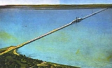
The James River Bridge is a four-lane divided highway
lift bridge
across the James River
in the U.S. state
of Virginia
. Owned and operated by the Virginia Department of Transportation
, it carries U.S. Route 17, U.S. Route 258, and State Route 32 across the river near its mouth at Hampton Roads
. The bridge connects Newport News
on the Virginia Peninsula
with Isle of Wight County
in the South Hampton Roads
region, and is the easternmost such crossing without a tunnel
component.
When completed in 1928, the 4.5-mile (7 km) bridge was the longest bridge in the world over water. The original two-lane bridge was replaced from 1975 to 1982 with a wider four-lane bridge that could handle increased traffic volumes. In 2005, the bridge carried an annual average daily traffic
of about 30,000 vehicles per day.
(carrying U.S. Route 17, U.S. Route 258, and State Route 32 onto the bridge) passes over Warwick Boulevard (U.S. Route 60). After an intersection with River Road and the entrance to Huntington Park, the four-lane divided
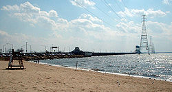
bridge begins, lying to the southeast of the part of the old bridge that remains as a fishing pier. The 126.5 m (415.0 ft) lift span
over the shipping channel, with a clearance of 44.1 m (145 ft) when raised and 18.2 m (59.7 ft) when lowered, is about 1/4 of the way along the 7.0714 km (4.3940 mi) bridge. This allows ocean-going ships to pass en route to civilian port facilities in Hopewell
and at the Port of Richmond
.
The roadway becomes Carrollton Boulevard on the Isle of Wight County end; after a number of intersections, US 258 and SR 32 turn west at Bartlett
towards State Route 10 at Benns Church
, while US 17 curves southeast towards Portsmouth.
The nearest upstream crossing of the James River is the Jamestown Ferry
(State Route 31); the next fixed crossing is the 1966 Benjamin Harrison Bridge (State Route 156) at Hopewell. When the bridge opened in 1928, the next bridge upstream was the 1913 Mayo Bridge in Richmond.
Downstream, both crossings of Hampton Roads
are bridge-tunnel
s for military reasons: the 1992 Monitor-Merrimac Bridge-Tunnel (Interstate 664) and 1957 Hampton Roads Bridge-Tunnel
(Interstate 64/U.S. Route 60).
Bicycle
s, moped
s, and pedestrian
s are banned from using the bridge; the easternmost crossing for them is the Jamestown Ferry
, about 25 miles (40.2 km) upstream. The State Highway and Transportation Commission banned these transportation modes from using the bridge in 1978 "in the interest of safety", due to high traffic and lack of sidewalk
s. Once the replacement bridge was completed, they returned to the question in 1983, and decided to continue the ban, since the new bridge also had no sidewalks or sufficient recovery area.
, Chuckatuck Creek
, and Nansemond River
, as well as approach roads. On the Newport News end, the bridge simply ended at an intersection with State Route 39/U.S. Route 60 (Virginia Avenue, now Warwick Boulevard). However, a large system of approach roads, including two smaller toll bridges, was built on the Isle of Wight County side. Traffic coming off the bridge reached a Y intersection at Bartlett
, at which it could head west over a private approach road past Carrollton
to State Route 10 at Benns Church
, or head southeast into Nansemond County. The first of the two smaller bridges was the Crittenden Bridge
over Chuckatuck Creek
(the county line) at Crittenden
, and the second, after passing the road to Hobson
and Chuckatuck
(now State Route 628), was the Nansemond River Bridge
over the Nansemond River
. The end of the private approach road was at the current intersection of Bennetts Pasture Road (State Route 627) and Lee Farm Lane (State Route 701), where one could go south to State Route 10 (now State Route 337) at Driver
. So the James River Bridge System served not only traffic crossing the James River, but also traffic along State Route 10; the 1928 Chuckatuck-Driver Kings Highway Bridge
(now State Route 125) competed with the James River Bridge System for this traffic.
The $5.2 million James River Bridge was opened on November 17, 1928 by the press of a button in Washington, D.C.
, where U.S. President Calvin Coolidge
, sitting in the Oval Office
of the White House
, sent an electric signal to lower into place the upraised lift span over the James River channel. Drivers could now choose to cross Hampton Roads on a fixed bridge rather than one of many ferries
. The new bridge was narrow by current standards, with a 20 feet (6.1 m) roadway from curb to curb, and railings much less substantial than found on modern structures. The main lift span was 300 feet (90 m) long; the other two bridges included 110-foot (34 m) bascule span
s. When completed, it was the longest bridge in the world over water.
From 1928 to 1931, State Route 503, a state highway
from Portsmouth via Churchland and Belleville
to the private approach road south of the Nansemond River, was added to the state highway system. U.S. Route 17 was moved onto this alignment (from one of the ferries) by 1932, and still uses it today. State Route 258, now part of U.S. Route 258, was extended over the Benns Church approach and bridge by late 1943 to reach the new Mercury Boulevard
. Thus all approaches had numbers at the time of the state takeover in 1949. In 1951, State Route 32 was extended from Suffolk over the bridge to end in Newport News, completely overlapped with other routes, "to facilitate the routing of traffic over the James River Bridge System, between points north of Newport News and south of Suffolk".
of the James River Bridge Corporation. It was bought by bondholders, headed by a local businessman from Smithfield. The new owners raised tolls, proving unpopular with local residents. Chapter 399 of the Acts of Virginia of 1940 authorized the SHC to acquire the James River Bridge System, consisting of the three bridges and approach roads. The SHC bought the system from the corporation for $5.6 million on September 30, 1949.
However, in 1955, the state doubled tolls to $1.80 round trip for cars and $4.00 or more for trucks, in order to pay for repairs, new toll booths, and a new punched card
system compatible with the Hampton Roads Bridge-Tunnel
. The toll plazas, which had numbered three - one for each bridge - were consolidated to two, one at the south end of the main bridge and one at the north end of the Nansemond River Bridge
. Thus the Crittenden Bridge
became free for local traffic. In addition, passenger vehicles and light truck
s only had to pay at the first booth they reached; large trucks and buses had to pay twice. This meant that light vehicles crossing only the main bridge (for instance between Smithfield and Newport News) only had to pay southbound.
J.W. Luter, Jr. of the local Smithfield Packing Company
rerouted his trucks via a smaller, cheaper bridge owned by a Norfolk car dealer. Tolls were eventually dropped to 10 cents per axle, and later removed on June 3, 1976; the state paid off the remaining bonds at that time. Simultaneously, the parallel Hampton Roads Bridge-Tunnel
opened, and tolls were removed from that facility, the Coleman Bridge, and the Robert O. Norris Bridge
. Many considered this an important step in the development of the area. The former toll building and parking area was used for maintenance workers, police, and tow truck drivers until 2002, when asbestos
was discovered. Despite the efforts of preservationist
s, who argued the building had historic significance, it was torn down in 2004.
 A new four-lane lift bridge was completed in stages from 1975 to 1982 at a cost of $75 million. The replacement was funded with road user taxes rather than toll revenue bond
s. When the new bridge was completed, a short section of the old bridge on the Newport News side was retained for use as a fishing pier.
Divided Highway
Divided Highway is a compilation album by American rock band The Doobie Brothers, released in 2003. . All tracks are taken from the albums Cycles and Brotherhood .-Track listing:...
lift bridge
Lift bridge
A vertical-lift bridge or lift bridge is a type of movable bridge in which a span rises vertically while remaining parallel with the deck....
across the James River
James River (Virginia)
The James River is a river in the U.S. state of Virginia. It is long, extending to if one includes the Jackson River, the longer of its two source tributaries. The James River drains a catchment comprising . The watershed includes about 4% open water and an area with a population of 2.5 million...
in the U.S. state
U.S. state
A U.S. state is any one of the 50 federated states of the United States of America that share sovereignty with the federal government. Because of this shared sovereignty, an American is a citizen both of the federal entity and of his or her state of domicile. Four states use the official title of...
of Virginia
Virginia
The Commonwealth of Virginia , is a U.S. state on the Atlantic Coast of the Southern United States. Virginia is nicknamed the "Old Dominion" and sometimes the "Mother of Presidents" after the eight U.S. presidents born there...
. Owned and operated by the Virginia Department of Transportation
Virginia Department of Transportation
The Virginia Department of Transportation is the agency of state government responsible for transportation in the state of Virginia in the United States. Headquartered in Downtown Richmond, VDOT is responsible for building, maintaining, and operating the roads, bridges and tunnels in the...
, it carries U.S. Route 17, U.S. Route 258, and State Route 32 across the river near its mouth at Hampton Roads
Hampton Roads
Hampton Roads is the name for both a body of water and the Norfolk–Virginia Beach metropolitan area which surrounds it in southeastern Virginia, United States...
. The bridge connects Newport News
Newport News, Virginia
Newport News is an independent city located in the Hampton Roads metropolitan area of Virginia. It is at the southeastern end of the Virginia Peninsula, on the north shore of the James River extending southeast from Skiffe's Creek along many miles of waterfront to the river's mouth at Newport News...
on the Virginia Peninsula
Virginia Peninsula
The Virginia Peninsula is a peninsula in southeast Virginia, USA, bounded by the York River, James River, Hampton Roads and Chesapeake Bay.Hampton Roads is the common name for the metropolitan area that surrounds the body of water of the same name...
with Isle of Wight County
Isle of Wight County, Virginia
As of the census of 2010, there were 35,270 people, 11,319 households, and 8,670 families residing in the county. The population density was 94 people per square mile . There were 12,066 housing units at an average density of 38 per square mile...
in the South Hampton Roads
South Hampton Roads
South Hampton Roads is a region located in the extreme southeastern portion of Virginia in the United States, and is part of the Virginia Beach-Norfolk-Newport News, VA-NC MSA with a population about 1.7 million....
region, and is the easternmost such crossing without a tunnel
Tunnel
A tunnel is an underground passageway, completely enclosed except for openings for egress, commonly at each end.A tunnel may be for foot or vehicular road traffic, for rail traffic, or for a canal. Some tunnels are aqueducts to supply water for consumption or for hydroelectric stations or are sewers...
component.
When completed in 1928, the 4.5-mile (7 km) bridge was the longest bridge in the world over water. The original two-lane bridge was replaced from 1975 to 1982 with a wider four-lane bridge that could handle increased traffic volumes. In 2005, the bridge carried an annual average daily traffic
Annual average daily traffic
Average Annual daily traffic, abbreviated AADT, is a measure used primarily in transportation planning and transportation engineering. It is the total volume of vehicle traffic of a highway or road for a year divided by 365 days. AADT is a useful and simple measurement of how busy the road is...
of about 30,000 vehicles per day.
Description of the current bridge
At the Newport News end, traffic approaches the bridge at a six-ramp partial cloverleaf interchange, where Mercury BoulevardMercury Boulevard
Mercury Boulevard in the cities of Hampton and Newport News in the Peninsula region of southeastern Virginia carries U.S. Highway 258 approximately south from Fort Monroe at Old Point Comfort on Hampton Roads to the north end of the James River Bridge...
(carrying U.S. Route 17, U.S. Route 258, and State Route 32 onto the bridge) passes over Warwick Boulevard (U.S. Route 60). After an intersection with River Road and the entrance to Huntington Park, the four-lane divided
Divided Highway
Divided Highway is a compilation album by American rock band The Doobie Brothers, released in 2003. . All tracks are taken from the albums Cycles and Brotherhood .-Track listing:...
bridge begins, lying to the southeast of the part of the old bridge that remains as a fishing pier. The 126.5 m (415.0 ft) lift span
Lift bridge
A vertical-lift bridge or lift bridge is a type of movable bridge in which a span rises vertically while remaining parallel with the deck....
over the shipping channel, with a clearance of 44.1 m (145 ft) when raised and 18.2 m (59.7 ft) when lowered, is about 1/4 of the way along the 7.0714 km (4.3940 mi) bridge. This allows ocean-going ships to pass en route to civilian port facilities in Hopewell
Hopewell, Virginia
Hopewell is an independent city in the Commonwealth of Virginia. The population was 22,591 at the 2010 Census . It is in Tri-Cities area of the Richmond-Petersburg region and is a portion of the Richmond Metropolitan Statistical Area...
and at the Port of Richmond
Port of Richmond
Also known as the Richmond Deepwater Terminal, the Port of Richmond is located on the James River in Richmond, Virginia, 100 miles from Cape Henry and approximately 78 miles north of Newport News, Virginia. It is located at 77° 25' west latitude and 37° 27' north longitude and lies adjacent to...
.
The roadway becomes Carrollton Boulevard on the Isle of Wight County end; after a number of intersections, US 258 and SR 32 turn west at Bartlett
Bartlett, Virginia
Bartlett is an unincorporated community in Isle of Wight County, Virginia, United States. It is located at the junction of U.S. Route 17, U.S. Route 258, and State Route 32, on the James River Bridge approach southeast of Smithfield....
towards State Route 10 at Benns Church
Benns Church, Virginia
Benns Church is a census-designated place in Isle of Wight County, Virginia, United States. It is located at the junction of U.S. Route 258 and State Routes 10 and 32, southeast of Smithfield. The population as of the 2010 Census was 872....
, while US 17 curves southeast towards Portsmouth.
The nearest upstream crossing of the James River is the Jamestown Ferry
Jamestown Ferry
The Jamestown Ferry is a free automobile and bus ferry service across a navigable portion of the James River in Virginia...
(State Route 31); the next fixed crossing is the 1966 Benjamin Harrison Bridge (State Route 156) at Hopewell. When the bridge opened in 1928, the next bridge upstream was the 1913 Mayo Bridge in Richmond.
Downstream, both crossings of Hampton Roads
Hampton Roads
Hampton Roads is the name for both a body of water and the Norfolk–Virginia Beach metropolitan area which surrounds it in southeastern Virginia, United States...
are bridge-tunnel
Bridge-tunnel
A fixed link, fixed crossing, or bridge-tunnel is a persistent, unbroken road or rail connection across water that uses some combination of bridges, tunnels, and causeways and does not involve intermittent connections such as drawbridges or ferries.The Confederation Bridge was commonly referred to...
s for military reasons: the 1992 Monitor-Merrimac Bridge-Tunnel (Interstate 664) and 1957 Hampton Roads Bridge-Tunnel
Hampton Roads Bridge-Tunnel
The Hampton Roads Bridge-Tunnel is the -long Hampton Roads crossing for Interstate 64 and U.S. Route 60. It is a four-lane facility comprising bridges, trestles, man-made islands, and tunnels under the main shipping channels for Hampton Roads harbor in the southeastern portion of Virginia in the...
(Interstate 64/U.S. Route 60).
Bicycle
Bicycle
A bicycle, also known as a bike, pushbike or cycle, is a human-powered, pedal-driven, single-track vehicle, having two wheels attached to a frame, one behind the other. A person who rides a bicycle is called a cyclist, or bicyclist....
s, moped
Moped
Mopeds are a type of low-powered motorcycle designed to provide economical and relatively safe transport with minimal licensing requirements.Mopeds were once all equipped with bicycle-like pedals , but moped has been increasingly applied by governments to vehicles without pedals, based on their...
s, and pedestrian
Pedestrian
A pedestrian is a person traveling on foot, whether walking or running. In some communities, those traveling using roller skates or skateboards are also considered to be pedestrians. In modern times, the term mostly refers to someone walking on a road or footpath, but this was not the case...
s are banned from using the bridge; the easternmost crossing for them is the Jamestown Ferry
Jamestown Ferry
The Jamestown Ferry is a free automobile and bus ferry service across a navigable portion of the James River in Virginia...
, about 25 miles (40.2 km) upstream. The State Highway and Transportation Commission banned these transportation modes from using the bridge in 1978 "in the interest of safety", due to high traffic and lack of sidewalk
Sidewalk
A sidewalk, or pavement, footpath, footway, and sometimes platform, is a path along the side of a road. A sidewalk may accommodate moderate changes in grade and is normally separated from the vehicular section by a curb...
s. Once the replacement bridge was completed, they returned to the question in 1983, and decided to continue the ban, since the new bridge also had no sidewalks or sufficient recovery area.
History: longest bridge in the world over water
The privately-owned James River Bridge Corporation was chartered by the General Assembly to build a system of bridges across the James RiverJames River (Virginia)
The James River is a river in the U.S. state of Virginia. It is long, extending to if one includes the Jackson River, the longer of its two source tributaries. The James River drains a catchment comprising . The watershed includes about 4% open water and an area with a population of 2.5 million...
, Chuckatuck Creek
Chuckatuck Creek
Chuckatuck Creek is a tributary of the James River in the U.S. state of Virginia. The creek rises in Isle of Wight County and flows southeast to Chuckatuck in the city of Suffolk, where it turns northeast as it passes under State Route 10/State Route 32...
, and Nansemond River
Nansemond River
The Nansemond River is a tributary of the James River in the U.S. state of Virginia. The Nansemond River Bridge crosses the river near its mouth. Both it and the former State Route 125 bridge, demolished in 2008, were once toll bridges. The river begins at the outlet of Lake Meade north of...
, as well as approach roads. On the Newport News end, the bridge simply ended at an intersection with State Route 39/U.S. Route 60 (Virginia Avenue, now Warwick Boulevard). However, a large system of approach roads, including two smaller toll bridges, was built on the Isle of Wight County side. Traffic coming off the bridge reached a Y intersection at Bartlett
Bartlett, Virginia
Bartlett is an unincorporated community in Isle of Wight County, Virginia, United States. It is located at the junction of U.S. Route 17, U.S. Route 258, and State Route 32, on the James River Bridge approach southeast of Smithfield....
, at which it could head west over a private approach road past Carrollton
Carrollton, Virginia
Carrollton is a census-designated place in Isle of Wight County, Virginia, United States. The population as of the 2010 Census was 4,574....
to State Route 10 at Benns Church
Benns Church, Virginia
Benns Church is a census-designated place in Isle of Wight County, Virginia, United States. It is located at the junction of U.S. Route 258 and State Routes 10 and 32, southeast of Smithfield. The population as of the 2010 Census was 872....
, or head southeast into Nansemond County. The first of the two smaller bridges was the Crittenden Bridge
Crittenden Bridge
The Crittenden Bridge, also known as the Chuckatuck Creek Bridge, is officially named The Sydney Hazelwood III Bridge after a prominent member of the Crittenden community. This bridge is part of U.S...
over Chuckatuck Creek
Chuckatuck Creek
Chuckatuck Creek is a tributary of the James River in the U.S. state of Virginia. The creek rises in Isle of Wight County and flows southeast to Chuckatuck in the city of Suffolk, where it turns northeast as it passes under State Route 10/State Route 32...
(the county line) at Crittenden
Crittenden, Virginia
Crittenden is an unincorporated community in the independent city of Suffolk, Virginia, United States. It is located along U.S. Route 17 just south of its crossing of Chuckatuck Creek....
, and the second, after passing the road to Hobson
Hobson, Virginia
Hobson is an unincorporated community in the independent city of Suffolk, Virginia, United States. It is located along State Route 628 southwest of U.S. Route 17, on the neck between Chuckatuck Creek and the Nansemond River....
and Chuckatuck
Chuckatuck, Virginia
Chuckatuck is a neighborhood of the independent city of Suffolk, Virginia, United States. It is located at the junction of State Route 10/State Route 32 and State Route 125, just south of SR 10/32's crossing of Chuckatuck Creek. Its elevation is 36 feet above mean sea level...
(now State Route 628), was the Nansemond River Bridge
Nansemond River Bridge
The Nansemond River Bridge, officially the Mills E. Godwin Bridge, is located in the independent city of Suffolk, Virginia and carries U.S. Route 17 across the Nansemond River....
over the Nansemond River
Nansemond River
The Nansemond River is a tributary of the James River in the U.S. state of Virginia. The Nansemond River Bridge crosses the river near its mouth. Both it and the former State Route 125 bridge, demolished in 2008, were once toll bridges. The river begins at the outlet of Lake Meade north of...
. The end of the private approach road was at the current intersection of Bennetts Pasture Road (State Route 627) and Lee Farm Lane (State Route 701), where one could go south to State Route 10 (now State Route 337) at Driver
Driver, Virginia
Driver is a neighborhood in the independent city of Suffolk, Virginia, United States. It is located at the junction of State Route 337, State Route 125, and State Route 627....
. So the James River Bridge System served not only traffic crossing the James River, but also traffic along State Route 10; the 1928 Chuckatuck-Driver Kings Highway Bridge
Kings Highway Bridge
Kings Highway Bridge was located on the Nansemond River in the independent city of Suffolk, Virginia, United States. Built in 1928, it carried traffic on the Kings Highway, also known as State Route 125, for over 75 years....
(now State Route 125) competed with the James River Bridge System for this traffic.
The $5.2 million James River Bridge was opened on November 17, 1928 by the press of a button in Washington, D.C.
Washington, D.C.
Washington, D.C., formally the District of Columbia and commonly referred to as Washington, "the District", or simply D.C., is the capital of the United States. On July 16, 1790, the United States Congress approved the creation of a permanent national capital as permitted by the U.S. Constitution....
, where U.S. President Calvin Coolidge
Calvin Coolidge
John Calvin Coolidge, Jr. was the 30th President of the United States . A Republican lawyer from Vermont, Coolidge worked his way up the ladder of Massachusetts state politics, eventually becoming governor of that state...
, sitting in the Oval Office
Oval Office
The Oval Office, located in the West Wing of the White House, is the official office of the President of the United States.The room features three large south-facing windows behind the president's desk, and a fireplace at the north end...
of the White House
White House
The White House is the official residence and principal workplace of the president of the United States. Located at 1600 Pennsylvania Avenue NW in Washington, D.C., the house was designed by Irish-born James Hoban, and built between 1792 and 1800 of white-painted Aquia sandstone in the Neoclassical...
, sent an electric signal to lower into place the upraised lift span over the James River channel. Drivers could now choose to cross Hampton Roads on a fixed bridge rather than one of many ferries
Ferry
A ferry is a form of transportation, usually a boat, but sometimes a ship, used to carry primarily passengers, and sometimes vehicles and cargo as well, across a body of water. Most ferries operate on regular, frequent, return services...
. The new bridge was narrow by current standards, with a 20 feet (6.1 m) roadway from curb to curb, and railings much less substantial than found on modern structures. The main lift span was 300 feet (90 m) long; the other two bridges included 110-foot (34 m) bascule span
Bascule bridge
A bascule bridge is a moveable bridge with a counterweight that continuously balances the span, or "leaf," throughout the entire upward swing in providing clearance for boat traffic....
s. When completed, it was the longest bridge in the world over water.
From 1928 to 1931, State Route 503, a state highway
State highway
State highway, state road or state route can refer to one of three related concepts, two of them related to a state or provincial government in a country that is divided into states or provinces :#A...
from Portsmouth via Churchland and Belleville
Belleville, Virginia
Belleville is an unincorporated community in the independent city of Suffolk, Virginia, United States. It is located at the junction of Interstate 664, U.S. Route 17, and State Route 164....
to the private approach road south of the Nansemond River, was added to the state highway system. U.S. Route 17 was moved onto this alignment (from one of the ferries) by 1932, and still uses it today. State Route 258, now part of U.S. Route 258, was extended over the Benns Church approach and bridge by late 1943 to reach the new Mercury Boulevard
Mercury Boulevard
Mercury Boulevard in the cities of Hampton and Newport News in the Peninsula region of southeastern Virginia carries U.S. Highway 258 approximately south from Fort Monroe at Old Point Comfort on Hampton Roads to the north end of the James River Bridge...
. Thus all approaches had numbers at the time of the state takeover in 1949. In 1951, State Route 32 was extended from Suffolk over the bridge to end in Newport News, completely overlapped with other routes, "to facilitate the routing of traffic over the James River Bridge System, between points north of Newport News and south of Suffolk".
Controversial tolls, ownership, shunpiking
As early as 1933, the State Highway Commission (SHC) considered taking over the bridge approaches - but not the bridges themselves - from the corporation. Projected traffic volumes were not reached, leading to bankruptcyBankruptcy
Bankruptcy is a legal status of an insolvent person or an organisation, that is, one that cannot repay the debts owed to creditors. In most jurisdictions bankruptcy is imposed by a court order, often initiated by the debtor....
of the James River Bridge Corporation. It was bought by bondholders, headed by a local businessman from Smithfield. The new owners raised tolls, proving unpopular with local residents. Chapter 399 of the Acts of Virginia of 1940 authorized the SHC to acquire the James River Bridge System, consisting of the three bridges and approach roads. The SHC bought the system from the corporation for $5.6 million on September 30, 1949.
However, in 1955, the state doubled tolls to $1.80 round trip for cars and $4.00 or more for trucks, in order to pay for repairs, new toll booths, and a new punched card
Punched card
A punched card, punch card, IBM card, or Hollerith card is a piece of stiff paper that contains digital information represented by the presence or absence of holes in predefined positions...
system compatible with the Hampton Roads Bridge-Tunnel
Hampton Roads Bridge-Tunnel
The Hampton Roads Bridge-Tunnel is the -long Hampton Roads crossing for Interstate 64 and U.S. Route 60. It is a four-lane facility comprising bridges, trestles, man-made islands, and tunnels under the main shipping channels for Hampton Roads harbor in the southeastern portion of Virginia in the...
. The toll plazas, which had numbered three - one for each bridge - were consolidated to two, one at the south end of the main bridge and one at the north end of the Nansemond River Bridge
Nansemond River Bridge
The Nansemond River Bridge, officially the Mills E. Godwin Bridge, is located in the independent city of Suffolk, Virginia and carries U.S. Route 17 across the Nansemond River....
. Thus the Crittenden Bridge
Crittenden Bridge
The Crittenden Bridge, also known as the Chuckatuck Creek Bridge, is officially named The Sydney Hazelwood III Bridge after a prominent member of the Crittenden community. This bridge is part of U.S...
became free for local traffic. In addition, passenger vehicles and light truck
Light truck
Light truck or light duty truck is a U.S. classification for trucks or truck-based vehicles with a payload capacity of less than 4,000 pounds...
s only had to pay at the first booth they reached; large trucks and buses had to pay twice. This meant that light vehicles crossing only the main bridge (for instance between Smithfield and Newport News) only had to pay southbound.
J.W. Luter, Jr. of the local Smithfield Packing Company
Smithfield Packing Company
Smithfield Packing Company was founded in 1936 by Joseph W. Luter and his son Joseph W. Luter, Jr., in the Town of Smithfield along the Pagan River, a tributary of the James River in Isle of Wight County, Virginia, USA, to produce Smithfield hams...
rerouted his trucks via a smaller, cheaper bridge owned by a Norfolk car dealer. Tolls were eventually dropped to 10 cents per axle, and later removed on June 3, 1976; the state paid off the remaining bonds at that time. Simultaneously, the parallel Hampton Roads Bridge-Tunnel
Hampton Roads Bridge-Tunnel
The Hampton Roads Bridge-Tunnel is the -long Hampton Roads crossing for Interstate 64 and U.S. Route 60. It is a four-lane facility comprising bridges, trestles, man-made islands, and tunnels under the main shipping channels for Hampton Roads harbor in the southeastern portion of Virginia in the...
opened, and tolls were removed from that facility, the Coleman Bridge, and the Robert O. Norris Bridge
Robert O. Norris Bridge
The Robert O. Norris bridge is a truss bridge that spans the Rappahannock River between Lancaster County and Middlesex County in Virginia. It serves as the crossing for Virginia State Route 3 over the river. It was opened on August 30, 1957, and replaced the old ferry service...
. Many considered this an important step in the development of the area. The former toll building and parking area was used for maintenance workers, police, and tow truck drivers until 2002, when asbestos
Asbestos
Asbestos is a set of six naturally occurring silicate minerals used commercially for their desirable physical properties. They all have in common their eponymous, asbestiform habit: long, thin fibrous crystals...
was discovered. Despite the efforts of preservationist
Preservationist
Preservationist is generally understood to mean historic preservationist: one who advocates to preserve architecturally or historically significant buildings, structures, objects or sites from demolition or degradation...
s, who argued the building had historic significance, it was torn down in 2004.
Replacement bridge without tolls: 1975-1982
Toll revenue bond
A toll revenue bond is a financial promissory note usually issued to generate funds for the construction and/or operation of a public accommodation such as an expressway, bridge, or tunnel...
s. When the new bridge was completed, a short section of the old bridge on the Newport News side was retained for use as a fishing pier.