
Easley Covered Bridge
Encyclopedia
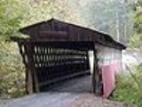
The Easley Covered Bridge, also known as the Old Easley Covered Bridge or Rosa Covered Bridge, is a county-owned wood and metal combination style covered bridge
that spans Dub Branch of the Calvert Prong of the Little Warrior River
in Blount County, Alabama
, United States
. It is located on Easley Bridge Road off U.S. Route 231
, just south of the town of Rosa
, about 5 miles (8 kilometers) northwest of Oneonta
. Coordinates are 33°58′16.12"N 86°31′7.39"W (33.971144, -86.518719).
Built in 1927, the 95-foot (29-meter) bridge is a town lattice truss construction over a single span. Its WGCB
number is 01-05-12. The Easley Covered Bridge was listed on the Alabama Register of Landmarks and Heritage
on March 3, 1976. It was listed on the National Register of Historic Places
on August 20, 1981. It is currently the oldest and shortest of three historic covered bridges still existing in Blount County. The bridge is closed to motor vehicle traffic due to safety concerns, but is still accessible from both sides of Easley Bridge Road. It is maintained by the Blount County Commission and the Alabama Department of Transportation
.
The Blount County Commission is currently working to secure funds for structural analysis and conservation of its three remaining covered bridges. They were closed as of 2009 due to safety concerns (the Horton Mill Covered Bridge
was closed in 2007 after vandalism occurred but reopened in late 2009). According to signs posted on both ends of the Easley Covered Bridge, the Blount County Commission is being criticized for lack of maintenance to its covered bridges over recent years.
Total Span Length: 83.0 ft (25.3 m)
Deck Width: 10.8 ft (3.3 m)
Vertical Clearance: 9.0 ft (2.7 m)
Above measurements are approximate and unofficial. Total span length is not always the same as total bridge length.
Covered bridge
A covered bridge is a bridge with enclosed sides and a roof, often accommodating only a single lane of traffic. Most covered bridges are wooden; some newer ones are concrete or metal with glass sides...
that spans Dub Branch of the Calvert Prong of the Little Warrior River
Calvert Prong of the Little Warrior River
The Calvert Prong of the Little Warrior River is a tributary of the Little Warrior River in the U.S. state of Alabama....
in Blount County, Alabama
Blount County, Alabama
Blount County is a county located in the U.S. state of Alabama. As of the 2010 United States Census, the population was 57,322. Its county seat is Oneonta.Blount County is a dry county.-History:...
, United States
United States
The United States of America is a federal constitutional republic comprising fifty states and a federal district...
. It is located on Easley Bridge Road off U.S. Route 231
U.S. Route 231
U.S. Route 231 is a parallel route of U.S. Route 31. It currently runs for 912 miles from St. John, Indiana, at U.S. Route 41 to south of U.S. Route 98 in Downtown Panama City, Florida.One of its most notable landmarks is the William H...
, just south of the town of Rosa
Rosa, Alabama
Rosa is a town in Blount County, Alabama, United States. At the 2000 census the population was 313.-Geography:Rosa is located at 33°59'23.316" North, 86°30'42.977" West .According to the U.S...
, about 5 miles (8 kilometers) northwest of Oneonta
Oneonta, Alabama
Oneonta is a city in Blount County, Alabama, United States. At the 2000 census the population was 5,576. The city is the county seat of Blount County...
. Coordinates are 33°58′16.12"N 86°31′7.39"W (33.971144, -86.518719).
Built in 1927, the 95-foot (29-meter) bridge is a town lattice truss construction over a single span. Its WGCB
World Guide to Covered Bridges
The World Guide to Covered Bridges is a covered bridge numbering system. The system was invented by John Diehl, the chairman of the Ohio Covered Bridge Committee. The committee first used the numbering system in 1953 to publish a list of covered bridges in Ohio....
number is 01-05-12. The Easley Covered Bridge was listed on the Alabama Register of Landmarks and Heritage
Alabama Register of Landmarks and Heritage
The Alabama Register of Landmarks and Heritage, commonly referred to as the Alabama Register, is an official listing of buildings, sites, structures, objects, and districts deemed worthy of preservation in the U.S. state of Alabama. These properties, which may be of national, state, and local...
on March 3, 1976. It was listed on the National Register of Historic Places
National Register of Historic Places
The National Register of Historic Places is the United States government's official list of districts, sites, buildings, structures, and objects deemed worthy of preservation...
on August 20, 1981. It is currently the oldest and shortest of three historic covered bridges still existing in Blount County. The bridge is closed to motor vehicle traffic due to safety concerns, but is still accessible from both sides of Easley Bridge Road. It is maintained by the Blount County Commission and the Alabama Department of Transportation
Alabama Department of Transportation
The Alabama Department of Transportation is the government agency responsible for transportation infrastructure in Alabama. The department is divided into nine geographical divisions, with a central office located in Montgomery.-External links:...
.
History
The Easley Covered Bridge was built by a crew led by Zelmer C. Tidwell and uncle Forrest Tidwell in 1927 over Dub Branch. Other than occasional repair work, this bridge has been in continuous use since it was constructed until its closure in 2009.The Blount County Commission is currently working to secure funds for structural analysis and conservation of its three remaining covered bridges. They were closed as of 2009 due to safety concerns (the Horton Mill Covered Bridge
Horton Mill Covered Bridge
The Horton Mill Covered Bridge is a state owned wooden covered bridge that spans the Calvert Prong of the Little Warrior River in Blount County, Alabama, United States. It is located on a river crossover to Ebell Road and Covered Bridge Circle off State Route 75 about 5 miles north of the city...
was closed in 2007 after vandalism occurred but reopened in late 2009). According to signs posted on both ends of the Easley Covered Bridge, the Blount County Commission is being criticized for lack of maintenance to its covered bridges over recent years.
Dimensions
Main Span Length: 35.1 ft (10.7 m)Total Span Length: 83.0 ft (25.3 m)
Deck Width: 10.8 ft (3.3 m)
Vertical Clearance: 9.0 ft (2.7 m)
Above measurements are approximate and unofficial. Total span length is not always the same as total bridge length.