

Interstate Bridge
Encyclopedia
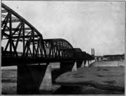
The Interstate Bridge is a pair of nearly identical steel vertical-lift, through-truss bridge
s that carry Interstate 5
traffic over the Columbia River
between Vancouver, Washington
, and Portland, Oregon
, in the United States
. The bridge first opened to traffic in 1917, as a single bridge carrying two-way traffic, but a second, twin bridge was opened in 1958, and each of these bridges carries only one-way traffic. The original 1917 structure is the northbound bridge. As of 2006, the bridge pair handles around 130,000 vehicles daily. The green structure, which is over 3500 feet (1,067 m) long, carries traffic over three northbound lanes and three southbound lanes. It was added to the National Register of Historic Places
in 1982, as the "Portland–Vancouver Highway Bridge".
system operated by Pacific Railway, Light & Power Co. Construction on the bridge began in March 1915, following the sale of bonds. The first bridge was opened on February 14, 1917 at a cost of $1.75 million, which was shared between Clark County
and Multnomah County
. Clark County paid $500,000 and Multnomah County $1,250,000. The first bridge has a total of 13 steel spans, with three measuring 275 feet (83.8 m) in length and the remaining ten spans 265 ft (80.8 m) each. One of the 275 feet (83.8 m) spans is the lift span for allowing river traffic under the bridge. The lift span is capable of moving 136 ft (41.5 m) vertically, and provides 176 ft (53.6 m) of clearance below when fully raised. The towers are
190 ft (57.9 m) tall, above the roadway.
 The original paved roadway was 38 ft (11.6 m) wide and had a 5 ft (1.52 m) wide sidewalk. It was the first automobile bridge across the river between Washington and Oregon, and the second to span the river at all, after the Wenatchee Bridge of 1908. It was originally a toll bridge costing 5¢ per vehicle or per horse and rider. In 1928 the states of Washington and Oregon jointly purchased the bridge from the counties and discontinued tolling the following year.
Electric streetcars operated across the bridge from opening day in 1917 until 1940. The bridge's deck carried dual-gauge
track, to accommodate both Vancouver's standard gauge
cars and Portland's narrow gauge
cars. Before the bridge, Portland had had a "Vancouver" streetcar line since 1893, but it actually only ran as far as Hayden Island
, where passengers transferred to a ferry
owned by the street railway company, to continue across the river to Vancouver. Streetcar service across the Interstate Bridge ended on September 3, 1940.
A $3 million upgrade to the lift cables, expansion joint
s, and a deck repaving was completed in 1990. The diesel generator
used to power the lift was replaced in 1995 at a cost of $150,000. In 1999 the bridge was repainted at a cost of $17 million. A $10.8 million electrical upgrade was completed in mid-May 2005.
The bridge is 3538 feet (1,078.4 m) long with a main span of 531 feet (161.8 m). The vertical lift provides 176 feet (53.6 m) of river clearance when fully opened. Openings last about ten minutes and occur between 10 and 20 times per month.
Signals for several miles each direction warn of bridge opening since traffic has to stop and wait. Due to this interruption, the Interstate Bridge is one of the Federal Highway Administration's highest priorities for replacement. Commercial river traffic schedules passage to avoid rush hour.
In 2006 the six total lanes of the bridges carried 130,000 vehicles daily. Full traffic capacity occurs four hours every day.
and Washington
state departments of transportation are jointly studying how to replace the bridge. Initially, the estimated cost for a replacement bridge was around $2 billion, but that number has climbed steadily to around $4.2 billion.
Design of a replacement (especially a fixed-span bridge) is complicated by the existence of a railroad drawbridge crossing the Columbia a short distance downriver (on the Burlington Northern Railroad Bridge 9.6
), which constrains the location of the shipping channel; and by approach paths to Portland International Airport
in Portland and to Pearson Field
in Vancouver, which limit the height of any new structure. Some have proposed replacing the bridge in a different location. There were originally 12 transportation plans that were being studied to improve and expand the Interstate 5 crossing of the Columbia River. In late 2006, 4 of these plans were selected for a final proposal, along with a fifth no-build option. The Columbia River Crossing
project's six local partner agencies selected a replacement I-5 bridge and light rail extension to Clark College as the project's Locally Preferred Alternative (LPA) in 2008.
There is also a longstanding debate as to whether or not a new bridge would include a MAX Light Rail line, express buses or bus rapid transit. During his 2007 "State of the City" address, Vancouver mayor Royce Pollard
stated
In December 2007, Oregon Governor
Ted Kulongoski
advocated for a new bridge, publicly endorsing the Oregon Business Plan's proposal.
In 2008, as fuel prices increased and project cost estimates soared, many in the area began questioning whether the project is worth the costs. In addition, many on the Portland side of the river fear that a 12 lane highway bridge to Vancouver, which has virtually no land use restrictions, will encourage suburban sprawl and development north of the river.
Further concerns over the 12-lane "Columbia River Crossing" (CRC) proposal include its failure to examine critical environmental impacts, such as damage to Clark County's drinking water supply, endangered fish habitat in the Columbia, and air pollution in North Portland.
In 2008, the Environmental Protection Agency found that the Draft Environmental Impact Statement for the CRC had failed to adequately cover these issues, as well as the potential induced demand for suburban sprawl. In a letter to CRC planners, the EPA wrote that "There was no indication (in the CRC environmental impact statement) of how these vulnerable populations might be impacted by air pollution, noise, diesel construction vehicles and increased traffic", referring to minority communities in North Portland.
Truss bridge
A truss bridge is a bridge composed of connected elements which may be stressed from tension, compression, or sometimes both in response to dynamic loads. Truss bridges are one of the oldest types of modern bridges...
s that carry Interstate 5
Interstate 5
Interstate 5 is the main Interstate Highway on the West Coast of the United States, running largely parallel to the Pacific Ocean coastline from Canada to Mexico . It serves some of the largest cities on the U.S...
traffic over the Columbia River
Columbia River
The Columbia River is the largest river in the Pacific Northwest region of North America. The river rises in the Rocky Mountains of British Columbia, Canada, flows northwest and then south into the U.S. state of Washington, then turns west to form most of the border between Washington and the state...
between Vancouver, Washington
Vancouver, Washington
Vancouver is a city on the north bank of the Columbia River in the U.S. state of Washington. Incorporated in 1857, it is the fourth largest city in the state with a 2010 census population of 161,791 as of April 1, 2010...
, and Portland, Oregon
Portland, Oregon
Portland is a city located in the Pacific Northwest, near the confluence of the Willamette and Columbia rivers in the U.S. state of Oregon. As of the 2010 Census, it had a population of 583,776, making it the 29th most populous city in the United States...
, in the United States
United States
The United States of America is a federal constitutional republic comprising fifty states and a federal district...
. The bridge first opened to traffic in 1917, as a single bridge carrying two-way traffic, but a second, twin bridge was opened in 1958, and each of these bridges carries only one-way traffic. The original 1917 structure is the northbound bridge. As of 2006, the bridge pair handles around 130,000 vehicles daily. The green structure, which is over 3500 feet (1,067 m) long, carries traffic over three northbound lanes and three southbound lanes. It was added to the National Register of Historic Places
National Register of Historic Places
The National Register of Historic Places is the United States government's official list of districts, sites, buildings, structures, and objects deemed worthy of preservation...
in 1982, as the "Portland–Vancouver Highway Bridge".
First bridge
The bridge was built to replace an overcrowded ferryFerry
A ferry is a form of transportation, usually a boat, but sometimes a ship, used to carry primarily passengers, and sometimes vehicles and cargo as well, across a body of water. Most ferries operate on regular, frequent, return services...
system operated by Pacific Railway, Light & Power Co. Construction on the bridge began in March 1915, following the sale of bonds. The first bridge was opened on February 14, 1917 at a cost of $1.75 million, which was shared between Clark County
Clark County, Washington
Clark County is a county located in the southwestern part of the U.S. state of Washington, across the Columbia River from Portland, Oregon.Clark County was the first county of Washington, named after William Clark of the Lewis and Clark Expedition...
and Multnomah County
Multnomah County, Oregon
Multnomah County is one of 36 counties in the U.S. state of Oregon. Though smallest in area, it is the most populous as its county seat, Portland, is the state's largest city...
. Clark County paid $500,000 and Multnomah County $1,250,000. The first bridge has a total of 13 steel spans, with three measuring 275 feet (83.8 m) in length and the remaining ten spans 265 ft (80.8 m) each. One of the 275 feet (83.8 m) spans is the lift span for allowing river traffic under the bridge. The lift span is capable of moving 136 ft (41.5 m) vertically, and provides 176 ft (53.6 m) of clearance below when fully raised. The towers are
190 ft (57.9 m) tall, above the roadway.
Electric streetcars operated across the bridge from opening day in 1917 until 1940. The bridge's deck carried dual-gauge
Dual gauge
A dual-gauge or mixed-gauge railway has railway track that allows trains of different gauges to use the same track. Generally, a dual-gauge railway consists of three rails, rather than the standard two rails. The two outer rails give the wider gauge, while one of the outer rails and the inner rail...
track, to accommodate both Vancouver's standard gauge
Standard gauge
The standard gauge is a widely-used track gauge . Approximately 60% of the world's existing railway lines are built to this gauge...
cars and Portland's narrow gauge
Cape gauge
Cape gauge is a track gauge of between the inside of the rail heads and is classified as narrow gauge. It has installations of around .The gauge was first used by Norwegian engineer Carl Abraham Pihl and the first line was opened in 1862.- Nomenclature :...
cars. Before the bridge, Portland had had a "Vancouver" streetcar line since 1893, but it actually only ran as far as Hayden Island
Hayden Island, Portland, Oregon
Hayden Island is an island in the Columbia River between Vancouver, Washington and Portland, Oregon. The wide main channel of the Columbia passes north of the island. To the south, sheltered by the island, is a smaller channel known as North Portland Harbor...
, where passengers transferred to a ferry
Ferry
A ferry is a form of transportation, usually a boat, but sometimes a ship, used to carry primarily passengers, and sometimes vehicles and cargo as well, across a body of water. Most ferries operate on regular, frequent, return services...
owned by the street railway company, to continue across the river to Vancouver. Streetcar service across the Interstate Bridge ended on September 3, 1940.
Upgrades
In 1958 a $14.5 million upgrade created a southbound span and doubled the capacity of the bridge. The new bridge was built with a "humpback" that provides 72 ft (21.9 m) of vertical clearance and minimizes bridge openings. At the time the new bridge was opened, the old one was temporarily closed for rebuilding to give it a matching humpback section. When both bridges were first open concurrently, in 1960, each span became permanently one-way only, and tolls were reinstated at $.20 for cars, $.40 for light trucks, and $.60 for heavy trucks and buses, until removed in 1966 after the construction expenses were paid off.A $3 million upgrade to the lift cables, expansion joint
Expansion joint
An expansion joint or movement joint is an assembly designed to safely absorb the heat-induced expansion and contraction of various construction materials, to absorb vibration, to hold certain parts together, or to allow movement due to ground settlement or earthquakes...
s, and a deck repaving was completed in 1990. The diesel generator
Diesel generator
A diesel generator is the combination of a diesel engine with an electrical generator to generate electrical energy....
used to power the lift was replaced in 1995 at a cost of $150,000. In 1999 the bridge was repainted at a cost of $17 million. A $10.8 million electrical upgrade was completed in mid-May 2005.
The bridge is 3538 feet (1,078.4 m) long with a main span of 531 feet (161.8 m). The vertical lift provides 176 feet (53.6 m) of river clearance when fully opened. Openings last about ten minutes and occur between 10 and 20 times per month.
Signals for several miles each direction warn of bridge opening since traffic has to stop and wait. Due to this interruption, the Interstate Bridge is one of the Federal Highway Administration's highest priorities for replacement. Commercial river traffic schedules passage to avoid rush hour.
In 2006 the six total lanes of the bridges carried 130,000 vehicles daily. Full traffic capacity occurs four hours every day.
Replacement
The bridge is frequently a bottleneck which impacts both traffic on the freeway, as well as on the river. The OregonOregon Department of Transportation
The Oregon Department of Transportation is a department of the state government of the U.S. state of Oregon responsible for systems of transportation. It was first established in 1969. It had been preceded by the Oregon State Highway Department which, along with the Oregon State Highway...
and Washington
Washington State Department of Transportation
The Washington State Department of Transportation , was established in 1905. The agency, led by a Secretary and overseen by the Governor, is a Washington governmental agency that constructs, maintains, and regulates the use of the state's transportation infrastructure...
state departments of transportation are jointly studying how to replace the bridge. Initially, the estimated cost for a replacement bridge was around $2 billion, but that number has climbed steadily to around $4.2 billion.
Design of a replacement (especially a fixed-span bridge) is complicated by the existence of a railroad drawbridge crossing the Columbia a short distance downriver (on the Burlington Northern Railroad Bridge 9.6
Burlington Northern Railroad Bridge 9.6
Burlington Northern Railroad Bridge 9.6 or BNSF Railway Bridge 9.6, also known as the Columbia River Railroad Bridge, is through truss railway bridge across the Columbia River, between Portland, Oregon, and Vancouver, Washington, owned and operated by BNSF Railway...
), which constrains the location of the shipping channel; and by approach paths to Portland International Airport
Portland International Airport
Portland International Airport is a joint civil-military airport and the largest airport in the U.S. state of Oregon, accounting for 90% of passenger travel and more than 95% of air cargo of the state. It is located within Portland's city limits just south of the Columbia River in Multnomah...
in Portland and to Pearson Field
Pearson Field
Pearson Field , is a city-owned public-use airport located one mile southeast of the central business district of Vancouver, a city in Clark County, Washington, United States....
in Vancouver, which limit the height of any new structure. Some have proposed replacing the bridge in a different location. There were originally 12 transportation plans that were being studied to improve and expand the Interstate 5 crossing of the Columbia River. In late 2006, 4 of these plans were selected for a final proposal, along with a fifth no-build option. The Columbia River Crossing
Columbia River Crossing
The Columbia River Crossing is a joint megaproject between the United States Oregon and Washington departments of transportation to address problems with US Interstate 5 where it crosses the Columbia River. Founded in 2005, it looks to replace the existing Interstate Bridge and other associated...
project's six local partner agencies selected a replacement I-5 bridge and light rail extension to Clark College as the project's Locally Preferred Alternative (LPA) in 2008.
There is also a longstanding debate as to whether or not a new bridge would include a MAX Light Rail line, express buses or bus rapid transit. During his 2007 "State of the City" address, Vancouver mayor Royce Pollard
Royce Pollard
Royce Pollard was the six-term mayor of Vancouver, Washington, the fourth largest city in Washington state. After a career as a U.S. Army officer ending in the late 1980s, he served a seven-year stint on the City Council...
stated
In December 2007, Oregon Governor
Governor of Oregon
The Governor of Oregon is the top executive of the government of the U.S. state of Oregon. The title of governor was also applied to the office of Oregon's chief executive during the provisional and U.S. territorial governments....
Ted Kulongoski
Ted Kulongoski
Theodore R. "Ted" Kulongoski is an American politician, who served as the 36th Governor of Oregon. A Democrat, he has served in both houses of the Oregon Legislative Assembly, as the state Insurance Commissioner, the Attorney General, and an Associate Justice on the Oregon Supreme Court.-Early...
advocated for a new bridge, publicly endorsing the Oregon Business Plan's proposal.
In 2008, as fuel prices increased and project cost estimates soared, many in the area began questioning whether the project is worth the costs. In addition, many on the Portland side of the river fear that a 12 lane highway bridge to Vancouver, which has virtually no land use restrictions, will encourage suburban sprawl and development north of the river.
Further concerns over the 12-lane "Columbia River Crossing" (CRC) proposal include its failure to examine critical environmental impacts, such as damage to Clark County's drinking water supply, endangered fish habitat in the Columbia, and air pollution in North Portland.
In 2008, the Environmental Protection Agency found that the Draft Environmental Impact Statement for the CRC had failed to adequately cover these issues, as well as the potential induced demand for suburban sprawl. In a letter to CRC planners, the EPA wrote that "There was no indication (in the CRC environmental impact statement) of how these vulnerable populations might be impacted by air pollution, noise, diesel construction vehicles and increased traffic", referring to minority communities in North Portland.