
Cohoes, New York
Encyclopedia
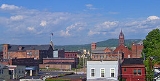
Cohoes is an incorporated city located at the northeast corner of Albany County
in the US state of New York
. It is called the "Spindle City" because of the importance of textile production to its growth. As of the 2010 census, the city population was 16,168. The name was believed to have arisen from a Mohawk expression, "Ga-ha-oose", referring to the Cohoes Falls
and meaning "Place of the Falling Canoe," an interpretation originated by Horatio Gates Spafford in his 1823 publication "A Gazetteer of the State of New York". Later historians posited that the name is derived from the Algonquian
"Cohos," which is a place name based on a word meaning 'pine tree'.
colonial feudal system; however the land north of a line crossing the Cohoes Falls (today Manor Avenue) was outside of the Manor and was owned by the Van Olohde family between 1725 and 1750. Rensselaerswyck was established by Killiaen Van Rensselaer, the patroon
and a Dutch
merchant. In 1632 he had an agent of his pace off an enormous triangle-shaped area around the confluence of the Mohawk and Hudson rivers, from the Peebles Island northwest to the Cohoes Falls and south to today's Watervliet
; this area was the core of the future city of Cohoes. Starting in the 1690s the Patroon began to issue leases for the area of Cohoes, though he did reserve for himself a strip below the Cohoes Falls for the future site of mills.
Though the area wasn't immediately heavily settled it was well-known for many reasons. The main was geographic, with the Cohoes Falls being the centerpiece. One of the earliest descriptions of the falls was in 1642 by Johannes Megapolensis, the first dominie (Reverend) of Beverwyck
. Another early description was in 1656 by Adriaen van der Donck
in his Description of New Netherland. In the early-to-mid 17th century a whale
had found itself stranded in the Mohawk River on an island just below the Cohoes Falls, it was impossible for the Dutch settlers of the area to remove the carcass and as it rotted the river became slick for three weeks from the rotting carcass and one commented that "the air was infected with its stench... perceptible for two miles to leeward"; around 1646 this island came to be known as Whale Island due to this occurrence.
During the various French and Indian Wars
during the mid-18th century Van Schaick Island
became the site of a military road that came from Albany north along the islands at the mouth of the Mohawk River. These islands allowed for easier fords across the various mouths of the Mohawk and access to Waterford and points north. The islands would be the site of many military encampments during both the French and Indian Wars and the US Revolutionary War. The Van Schaick Mansion on Van Schaick Island was built in the 1730s and was one of the sites used as a military headquarters by the Americans under General Philip Schuyler
and General Horatio Gates
. Van Schaick Island was the first part of Cohoes to be settled and farmed, it was formerly known as Cohoes Island and Anthony's Island.
Until the Revolutionary war Cohoes was a small quiet hamlet with isolated farms, after the Revolution things slowly began to pick up and Cohoes was linked to the larger settlements of Lansingburg and Albany. In 1795 at Cohoes the first bridge across the Mohawk River was constructed, it was 900 feet long, 24 feet wide, 15 feet high and sat on 13 stone piers. It cost $12,000 to build and was a toll bridge. This bridge increased the importance of Cohoes as it became one of the main routes north. It was rebuilt in 1806 by the Cohoes Bridge Company and tolls increased. The Erie
and Champlain Canal
s were begun in 1817 and the section in Cohoes finished in 1823, they would impact Cohoes in a every aspect, Cohoes was even known as Juncta because of this. Every farm in Cohoes was crossed by one or both of the canals, and Cohoes was the site of the junction of the two canals. Even with the canals and the bridge bringing easier access to larger markets Cohoes was a sleepy place to be in prior to 1831, the nearest post office was at Waterford and fresh meat and groceries were a luxury hard to come by in Cohoes. A post office in Cohoes was finally built in 1831.
In 1811 the Cohoes Manufacturing Company, owned entirely by men from Lansingburg, was incorporated and began a factory for making screws, this would be the first use of large industry in Cohoes and the harnessing of the Mohawk River and Cohoes Falls for power.
In 1831, a dam
was constructed on the Mohawk River above the city's waterfall by the new Cohoes Company, it was soon swept away by ice and a new one was built the following year. Two canals from the dam provided power for industries. Originally ironworks were the main industry calling Cohoes home, in this it was similar to Troy, Menands
, and West Troy. Daniel Simmons' Simmons Axe Company was famous throughout the United States and the Cohoes Iron Foundry was a large business enterprise in the 1830s. Cotton however would be the future of Cohoes. It had a small start in the 1820s when the only cotton mill in Albany County was located in Cohoes. Egberts and Bailey was the first factory to use knitting machinery run by power thanks to the Cohoes Company's power canals. This provided power to make the community a leading textile center with the establishment in 1836 of the Harmony Manufacturing Company, later famous as Harmony Mills
. Cohoes became a mill town
and to an extent a company town
. During the 1870s the mills were enormously profitable because of the Erie Canal
, which flowed past them at that time. Mill #3, at over 1000 feet (304.8 m) long, has been considered the longest continuous textile mill in the country at the time. In 1848, Cohoes was incorporated as a village within the town of Watervliet
, and in 1869 chartered as a city.

In 1866, during excavation work for construction of Mill #3 of the Harmony Mills, the bones of a mastodon
were unearthed over a period of several weeks. The Cohoes Mastodon skeleton was on display in the lobby of the New York State Museum
in Albany, New York
, but has recently been moved to a new location away from the windows of the lobby, where temperature and humidity fluxuations risked damaging the skeleton, to a new display near the rear of the museum. A furry replica can be seen at the Cohoes Public Library.
The 19th century saw an influx of immigrants to Cohoes to work in the mills, particularly French Canadian
s from Quebec
, and Irish
.
Around the turn of the century, daredevil Bobby Leach practiced going over the Cohoes Falls in a barrel before he performed the same stunt at Niagara. Cohoes residents watched this feat from the lawn or the porch of The Cataract House, the Victorian hotel at the corner of North Mohawk and School Streets, site of the present School Street Power Station.
served as mayor from 1870 to 1872 and as Congressman from 1877 to 1879.
Ron Canestrari served as mayor from 1976–1988 and as Assemblyman from 1988–Present, becoming Majority Leader in 2007.
Renowned author Kurt Vonnegut created a fictional character, the writer Kilgore Trout
, who was said to have been a resident of Cohoes.
 Cohoes is located at 42°46′24"N 73°42′11"W (42.773250, -73.703110).
According to the United States Census Bureau
, the city has a total area of 4.2 square miles (10.9 km²), of which, 3.7 square miles (9.6 km²) of it is land and 0.5 square miles (1.3 km²) of it (11.79%) is water.
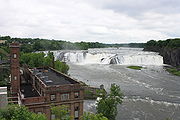
Cohoes is at the confluence of the Mohawk River
and the Hudson River
, where the Mohawk forms several channels and islands
. Cohoes is named for its most famous landmark, the Cohoes Falls
, a majestic waterfall that was discovered by the region's original settlers, the Mohawk Nation
. The city includes Van Schaick Island, where the historic Van Schaick Mansion is located, and Simmons Island.
The city borders to the north Saratoga County
, and Rensselaer
County to the east. Within Albany County the city has the town of Colonie to its northwest, west, and south; with the town and village of Green Island
to the south of Van Schaick Island. To the east of Van Schaick Island across the Hudson River is Rensselaer County and the city of Troy's Lansingburg neighborhood. To the north across the Mohawk River is Saratoga County and the town of Waterford's hamlet of Northside. A bridge connects Cohoes to Waterford, and the 112th Street Bridge
connects Van Schaick Island to Troy.
 As of the census
of 2000, there were 15,521 people (1,304 fewer than the 1990 census), 6,932 households, and 3,861 families residing in the city. The population density
was 4,145.8 people per square mile (1,602.3/km²). There were 7,689 housing units at an average density of 2,053.8 per square mile (793.8/km²). The racial makeup of the city was 95.14% White, 2.16% African American, 0.16% Native American, 0.68% Asian, 0.04% Pacific Islander, 0.59% from other races
, and 1.23% from two or more races. Hispanic or Latino of any race were 2.03% of the population.
There were 6,932 households out of which 25.9% had children under the age of 18 living with them, 36.4% were married couples
living together, 15.3% had a female householder with no husband present, and 44.3% were non-families. 38.0% of all households were made up of individuals and 15.6% had someone living alone who was 65 years of age or older. The average household size was 2.20 and the average family size was 2.91.
In the city the population was spread out with 22.4% under the age of 18, 8.5% from 18 to 24, 29.3% from 25 to 44, 22.5% from 45 to 64, and 17.3% who were 65 years of age or older. The median age was 38 years. For every 100 females there were 86.1 males. For every 100 females age 18 and over, there were 81.6 males.
The median income for a household in the city was $32,856, and the median income for a family was $42,054. Males had a median income of $31,972 versus $25,845 for females. The per capita income
for the city was $18,416. About 11.2% of families and 13.3% of the population were below the poverty line, including 22.9% of those under age 18 and 6.3% of those age 65 or over.
Albany County, New York
Albany County is a county located in the U.S. state of New York, and is part of the Albany-Schenectady-Troy Metropolitan Statistical Area. The name is from the title of the Duke of York and Albany, who became James II of England . As of the 2010 census, the population was 304,204...
in the US state of New York
New York
New York is a state in the Northeastern region of the United States. It is the nation's third most populous state. New York is bordered by New Jersey and Pennsylvania to the south, and by Connecticut, Massachusetts and Vermont to the east...
. It is called the "Spindle City" because of the importance of textile production to its growth. As of the 2010 census, the city population was 16,168. The name was believed to have arisen from a Mohawk expression, "Ga-ha-oose", referring to the Cohoes Falls
Cohoes Falls
Cohoes Falls is a waterfall on the Mohawk River shared by the city of Cohoes and the town of Waterford, New York, United States. Discovered by the indigenous Mohawk tribe, the falls were originally called Ga-ha-oose, which is believed to mean "The Place of the Falling Canoe." Cohoes historian...
and meaning "Place of the Falling Canoe," an interpretation originated by Horatio Gates Spafford in his 1823 publication "A Gazetteer of the State of New York". Later historians posited that the name is derived from the Algonquian
Algonquian languages
The Algonquian languages also Algonkian) are a subfamily of Native American languages which includes most of the languages in the Algic language family. The name of the Algonquian language family is distinguished from the orthographically similar Algonquin dialect of the Ojibwe language, which is a...
"Cohos," which is a place name based on a word meaning 'pine tree'.
History
The majority of the city was once part of the Manor of Rensselaerswyck, a DutchNetherlands
The Netherlands is a constituent country of the Kingdom of the Netherlands, located mainly in North-West Europe and with several islands in the Caribbean. Mainland Netherlands borders the North Sea to the north and west, Belgium to the south, and Germany to the east, and shares maritime borders...
colonial feudal system; however the land north of a line crossing the Cohoes Falls (today Manor Avenue) was outside of the Manor and was owned by the Van Olohde family between 1725 and 1750. Rensselaerswyck was established by Killiaen Van Rensselaer, the patroon
Patroon
In the United States, a patroon was a landholder with manorial rights to large tracts of land in the 17th century Dutch colony of New Netherland in North America...
and a Dutch
Dutch people
The Dutch people are an ethnic group native to the Netherlands. They share a common culture and speak the Dutch language. Dutch people and their descendants are found in migrant communities worldwide, notably in Suriname, Chile, Brazil, Canada, Australia, South Africa, New Zealand, and the United...
merchant. In 1632 he had an agent of his pace off an enormous triangle-shaped area around the confluence of the Mohawk and Hudson rivers, from the Peebles Island northwest to the Cohoes Falls and south to today's Watervliet
Watervliet, New York
Watervliet is a city in Albany County in the US state of New York. The population was 10,254 as of the 2010 census. Watervliet is north of Albany, the capital of the state, and is bordered on the north, west, and south by the town of Colonie. The city is also known as "the Arsenal City".- History...
; this area was the core of the future city of Cohoes. Starting in the 1690s the Patroon began to issue leases for the area of Cohoes, though he did reserve for himself a strip below the Cohoes Falls for the future site of mills.
Though the area wasn't immediately heavily settled it was well-known for many reasons. The main was geographic, with the Cohoes Falls being the centerpiece. One of the earliest descriptions of the falls was in 1642 by Johannes Megapolensis, the first dominie (Reverend) of Beverwyck
Beverwyck
Beverwijck was a fur-trading community north of Fort Orange on the Hudson River in New Netherland that was to become Albany, New York, when the English took control of the colony in 1664....
. Another early description was in 1656 by Adriaen van der Donck
Adriaen van der Donck
Adriaen Cornelissen van der Donck was a lawyer and landowner in New Netherland after whose honorific Jonkheer the city of Yonkers, New York is named...
in his Description of New Netherland. In the early-to-mid 17th century a whale
Whale
Whale is the common name for various marine mammals of the order Cetacea. The term whale sometimes refers to all cetaceans, but more often it excludes dolphins and porpoises, which belong to suborder Odontoceti . This suborder also includes the sperm whale, killer whale, pilot whale, and beluga...
had found itself stranded in the Mohawk River on an island just below the Cohoes Falls, it was impossible for the Dutch settlers of the area to remove the carcass and as it rotted the river became slick for three weeks from the rotting carcass and one commented that "the air was infected with its stench... perceptible for two miles to leeward"; around 1646 this island came to be known as Whale Island due to this occurrence.
During the various French and Indian Wars
French and Indian Wars
The French and Indian Wars is a name used in the United States for a series of conflicts lasting 74 years in North America that represented colonial events related to the European dynastic wars...
during the mid-18th century Van Schaick Island
Van Schaick Island
Van Schaick Island is an island in the city of Cohoes, New York. Van Schaick is a part of the delta of the Mohawk River at its mouth with the Hudson River. The island has been referred to by numerous names including Quehemesicos, Long, Anthony's, Isle of Cohoes, and Cohoes Island...
became the site of a military road that came from Albany north along the islands at the mouth of the Mohawk River. These islands allowed for easier fords across the various mouths of the Mohawk and access to Waterford and points north. The islands would be the site of many military encampments during both the French and Indian Wars and the US Revolutionary War. The Van Schaick Mansion on Van Schaick Island was built in the 1730s and was one of the sites used as a military headquarters by the Americans under General Philip Schuyler
Philip Schuyler
Philip John Schuyler was a general in the American Revolution and a United States Senator from New York. He is usually known as Philip Schuyler, while his son is usually known as Philip J. Schuyler.-Early life:...
and General Horatio Gates
Horatio Gates
Horatio Lloyd Gates was a retired British soldier who served as an American general during the Revolutionary War. He took credit for the American victory at the Battle of Saratoga – Benedict Arnold, who led the attack, was finally forced from the field when he was shot in the leg – and...
. Van Schaick Island was the first part of Cohoes to be settled and farmed, it was formerly known as Cohoes Island and Anthony's Island.
Until the Revolutionary war Cohoes was a small quiet hamlet with isolated farms, after the Revolution things slowly began to pick up and Cohoes was linked to the larger settlements of Lansingburg and Albany. In 1795 at Cohoes the first bridge across the Mohawk River was constructed, it was 900 feet long, 24 feet wide, 15 feet high and sat on 13 stone piers. It cost $12,000 to build and was a toll bridge. This bridge increased the importance of Cohoes as it became one of the main routes north. It was rebuilt in 1806 by the Cohoes Bridge Company and tolls increased. The Erie
Erie Canal
The Erie Canal is a waterway in New York that runs about from Albany, New York, on the Hudson River to Buffalo, New York, at Lake Erie, completing a navigable water route from the Atlantic Ocean to the Great Lakes. The canal contains 36 locks and encompasses a total elevation differential of...
and Champlain Canal
Champlain Canal
The Champlain Canal is a canal that connects the south end of Lake Champlain to the Hudson River in New York. It was simultaneously constructed with the Erie Canal and is now part of the New York State Canal System and the Lakes to Locks Passage....
s were begun in 1817 and the section in Cohoes finished in 1823, they would impact Cohoes in a every aspect, Cohoes was even known as Juncta because of this. Every farm in Cohoes was crossed by one or both of the canals, and Cohoes was the site of the junction of the two canals. Even with the canals and the bridge bringing easier access to larger markets Cohoes was a sleepy place to be in prior to 1831, the nearest post office was at Waterford and fresh meat and groceries were a luxury hard to come by in Cohoes. A post office in Cohoes was finally built in 1831.
In 1811 the Cohoes Manufacturing Company, owned entirely by men from Lansingburg, was incorporated and began a factory for making screws, this would be the first use of large industry in Cohoes and the harnessing of the Mohawk River and Cohoes Falls for power.
In 1831, a dam
Dam
A dam is a barrier that impounds water or underground streams. Dams generally serve the primary purpose of retaining water, while other structures such as floodgates or levees are used to manage or prevent water flow into specific land regions. Hydropower and pumped-storage hydroelectricity are...
was constructed on the Mohawk River above the city's waterfall by the new Cohoes Company, it was soon swept away by ice and a new one was built the following year. Two canals from the dam provided power for industries. Originally ironworks were the main industry calling Cohoes home, in this it was similar to Troy, Menands
Menands, New York
Menands is a village in Albany County, New York, United States. The population was 3,990 at the 2010 census. The village is named after Louis Menand...
, and West Troy. Daniel Simmons' Simmons Axe Company was famous throughout the United States and the Cohoes Iron Foundry was a large business enterprise in the 1830s. Cotton however would be the future of Cohoes. It had a small start in the 1820s when the only cotton mill in Albany County was located in Cohoes. Egberts and Bailey was the first factory to use knitting machinery run by power thanks to the Cohoes Company's power canals. This provided power to make the community a leading textile center with the establishment in 1836 of the Harmony Manufacturing Company, later famous as Harmony Mills
Harmony Mills
Harmony Mills, in Cohoes, New York, United States, is an industrial district that is bordered by the Mohawk River and the old Erie Canal. It was listed as Harmony Mills Historic District on the National Register of Historic Places in 1978, and it was further declared a National Historic Landmark...
. Cohoes became a mill town
Mill town
A mill town, also known as factory town or mill village, is typically a settlement that developed around one or more mills or factories .- United Kingdom:...
and to an extent a company town
Company town
A company town is a town or city in which much or all real estate, buildings , utilities, hospitals, small businesses such as grocery stores and gas stations, and other necessities or luxuries of life within its borders are owned by a single company...
. During the 1870s the mills were enormously profitable because of the Erie Canal
Erie Canal
The Erie Canal is a waterway in New York that runs about from Albany, New York, on the Hudson River to Buffalo, New York, at Lake Erie, completing a navigable water route from the Atlantic Ocean to the Great Lakes. The canal contains 36 locks and encompasses a total elevation differential of...
, which flowed past them at that time. Mill #3, at over 1000 feet (304.8 m) long, has been considered the longest continuous textile mill in the country at the time. In 1848, Cohoes was incorporated as a village within the town of Watervliet
Watervliet (town), New York
For the Shaker village, see Watervliet Shaker Historic District.The town of Watervliet was a town that at its height encompassed most of present-day Albany County and the majority of the current town of Niskayuna in neighboring Schenectady County, in the state of New York, United States...
, and in 1869 chartered as a city.
In 1866, during excavation work for construction of Mill #3 of the Harmony Mills, the bones of a mastodon
Mastodon
Mastodons were large tusked mammal species of the extinct genus Mammut which inhabited Asia, Africa, Europe, North America and Central America from the Oligocene through Pleistocene, 33.9 mya to 11,000 years ago. The American mastodon is the most recent and best known species of the group...
were unearthed over a period of several weeks. The Cohoes Mastodon skeleton was on display in the lobby of the New York State Museum
New York State Museum
The New York State Museum is a research-backed institution in Albany, New York, United States. It is located on Madison Avenue, attached to the south side of the Empire State Plaza, facing onto the plaza and towards the New York State Capitol...
in Albany, New York
Albany, New York
Albany is the capital city of the U.S. state of New York, the seat of Albany County, and the central city of New York's Capital District. Roughly north of New York City, Albany sits on the west bank of the Hudson River, about south of its confluence with the Mohawk River...
, but has recently been moved to a new location away from the windows of the lobby, where temperature and humidity fluxuations risked damaging the skeleton, to a new display near the rear of the museum. A furry replica can be seen at the Cohoes Public Library.
The 19th century saw an influx of immigrants to Cohoes to work in the mills, particularly French Canadian
French Canadian
French Canadian or Francophone Canadian, , generally refers to the descendents of French colonists who arrived in New France in the 17th and 18th centuries...
s from Quebec
Quebec
Quebec or is a province in east-central Canada. It is the only Canadian province with a predominantly French-speaking population and the only one whose sole official language is French at the provincial level....
, and Irish
Irish people
The Irish people are an ethnic group who originate in Ireland, an island in northwestern Europe. Ireland has been populated for around 9,000 years , with the Irish people's earliest ancestors recorded having legends of being descended from groups such as the Nemedians, Fomorians, Fir Bolg, Tuatha...
.
Around the turn of the century, daredevil Bobby Leach practiced going over the Cohoes Falls in a barrel before he performed the same stunt at Niagara. Cohoes residents watched this feat from the lawn or the porch of The Cataract House, the Victorian hotel at the corner of North Mohawk and School Streets, site of the present School Street Power Station.
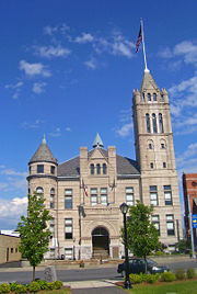
Historic sites
A number of sites in Cohoes are included on the U.S. National Register of Historic Places, including -- Harmony Mills Historic DistrictHarmony MillsHarmony Mills, in Cohoes, New York, United States, is an industrial district that is bordered by the Mohawk River and the old Erie Canal. It was listed as Harmony Mills Historic District on the National Register of Historic Places in 1978, and it was further declared a National Historic Landmark...
- Downtown Historic District
- Godfrey FarmhouseGodfrey FarmhouseGodfrey Farmhouse is a historic home located at Cohoes in Albany County, New York. It was built about 1836 and is a -story Greek Revival temple form dwelling. It features an impressive portico with fluted columns....
- Fonda HouseFonda HouseFonda House is a historic home located at Cohoes in Albany County, New York. It was built about 1727 and is a rectangular -story, three-by-two-bay center entrance brick dwelling with a gambrel roof. It features a single-story wraparound porch....
- J. Leonard Lackman HouseJ. Leonard Lackman HouseThe J. Leonard Lackman House is located on Imperial Avenue in Cohoes, New York, United States. Lackman was a local gunsmith and locksmith. His descendants still own and reside in the house as of 2009....
- William J. Dickey HouseWilliam J. Dickey HouseThe William J. Dickey House is located on Imperial Avenue in Cohoes, New York, United States. It was built for Dickey, the superintendent of a local textile mill, in 1890, by an unknown architect....
- Enlarged Erie Canal Sites Historic District, which includes Lock 18
- Cohoes Music HallCohoes Music HallCohoes Music Hall is located at 58 Remsen Street in Cohoes, New York, United States. It is a four-story brick building in the Second Empire architectural style. Built in 1874, it is considered the best example of that style in the city , with an unusually decorative front facade.In 1971 it was...
- Delaware & Hudson Freight House
- Olmstead Street Historic DistrictOlmstead Street Historic DistrictThe Olmstead Street Historic District is located along two blocks of that street in Cohoes, New York, United States. It is a microcosm of the city's economy at its peak in the mid- to late 19th century, consisting of a former textile mill complex, a filled-in section of the original Erie Canal, and...
- Van Schaick Mansion
Residents of note
Charles H. AdamsCharles H. Adams
Charles Henry Adams was a United States Representative from New York. Born in Coxsackie, he attended the public schools, studied law, was admitted to the bar about 1845 and commenced practice in New York City. He moved to Cohoes in 1850 and in 1851 was appointed with rank of colonel to Governor...
served as mayor from 1870 to 1872 and as Congressman from 1877 to 1879.
Ron Canestrari served as mayor from 1976–1988 and as Assemblyman from 1988–Present, becoming Majority Leader in 2007.
Renowned author Kurt Vonnegut created a fictional character, the writer Kilgore Trout
Kilgore Trout
Kilgore Trout is a fictional character created by author Kurt Vonnegut. He was originally created as a fictionalized version of author Theodore Sturgeon , although Trout's consistent presence in Vonnegut's works has also led critics to view him as the author's own alter ego...
, who was said to have been a resident of Cohoes.
Geography
According to the United States Census Bureau
United States Census Bureau
The United States Census Bureau is the government agency that is responsible for the United States Census. It also gathers other national demographic and economic data...
, the city has a total area of 4.2 square miles (10.9 km²), of which, 3.7 square miles (9.6 km²) of it is land and 0.5 square miles (1.3 km²) of it (11.79%) is water.
Cohoes is at the confluence of the Mohawk River
Mohawk River
The Mohawk River is a river in the U.S. state of New York. It is the largest tributary of the Hudson River. The Mohawk flows into the Hudson in the Capital District, a few miles north of the city of Albany. The river is named for the Mohawk Nation of the Iroquois Confederacy...
and the Hudson River
Hudson River
The Hudson is a river that flows from north to south through eastern New York. The highest official source is at Lake Tear of the Clouds, on the slopes of Mount Marcy in the Adirondack Mountains. The river itself officially begins in Henderson Lake in Newcomb, New York...
, where the Mohawk forms several channels and islands
Sprouts of the Mohawk River
The Sprouts of the Mohawk River are the multiple channels of the Mohawk River as it flows into the Hudson River creating a delta in the US state of New York. Most of the sprouts lie within Albany County, with the northern ones in Saratoga County, and the sprouts enter the Hudson at the boundary...
. Cohoes is named for its most famous landmark, the Cohoes Falls
Cohoes Falls
Cohoes Falls is a waterfall on the Mohawk River shared by the city of Cohoes and the town of Waterford, New York, United States. Discovered by the indigenous Mohawk tribe, the falls were originally called Ga-ha-oose, which is believed to mean "The Place of the Falling Canoe." Cohoes historian...
, a majestic waterfall that was discovered by the region's original settlers, the Mohawk Nation
Mohawk nation
Mohawk are the most easterly tribe of the Iroquois confederation. They call themselves Kanien'gehaga, people of the place of the flint...
. The city includes Van Schaick Island, where the historic Van Schaick Mansion is located, and Simmons Island.
The city borders to the north Saratoga County
Saratoga County, New York
Saratoga County is a county located in the U.S. state of New York. As of the 2010 census, the population was 219,607. It is part of the Albany-Schenectady-Troy Metropolitan Statistical Area. The county seat is Ballston Spa...
, and Rensselaer
Rensselaer County, New York
Rensselaer County is a county in the U.S. state of New York. As of the 2010 census, the population was 159,429. Its name is in honor of the family of Kiliaen van Rensselaer, the original Dutch owner of the land in the area. Its county seat is Troy...
County to the east. Within Albany County the city has the town of Colonie to its northwest, west, and south; with the town and village of Green Island
Green Island, New York
Green Island is a coterminous town and village in Albany County, New York, USA some 8 miles north of Albany, New York. Green Island is one of only five such town-village amalgams in New York. The population was 2,620 at the 2010 census...
to the south of Van Schaick Island. To the east of Van Schaick Island across the Hudson River is Rensselaer County and the city of Troy's Lansingburg neighborhood. To the north across the Mohawk River is Saratoga County and the town of Waterford's hamlet of Northside. A bridge connects Cohoes to Waterford, and the 112th Street Bridge
112th Street Bridge
The 112th Street Bridge is a bridge that carries New York State Route 470 across the Hudson River in New York. It connects Van Schaick Island in the city of Cohoes with the Lansingburgh neighborhood of Troy. The original bridge was built in 1922 and demolished in 1995. The newer version was...
connects Van Schaick Island to Troy.
Location
Demographics
Census
A census is the procedure of systematically acquiring and recording information about the members of a given population. It is a regularly occurring and official count of a particular population. The term is used mostly in connection with national population and housing censuses; other common...
of 2000, there were 15,521 people (1,304 fewer than the 1990 census), 6,932 households, and 3,861 families residing in the city. The population density
Population density
Population density is a measurement of population per unit area or unit volume. It is frequently applied to living organisms, and particularly to humans...
was 4,145.8 people per square mile (1,602.3/km²). There were 7,689 housing units at an average density of 2,053.8 per square mile (793.8/km²). The racial makeup of the city was 95.14% White, 2.16% African American, 0.16% Native American, 0.68% Asian, 0.04% Pacific Islander, 0.59% from other races
Race (United States Census)
Race and ethnicity in the United States Census, as defined by the Federal Office of Management and Budget and the United States Census Bureau, are self-identification data items in which residents choose the race or races with which they most closely identify, and indicate whether or not they are...
, and 1.23% from two or more races. Hispanic or Latino of any race were 2.03% of the population.
There were 6,932 households out of which 25.9% had children under the age of 18 living with them, 36.4% were married couples
Marriage
Marriage is a social union or legal contract between people that creates kinship. It is an institution in which interpersonal relationships, usually intimate and sexual, are acknowledged in a variety of ways, depending on the culture or subculture in which it is found...
living together, 15.3% had a female householder with no husband present, and 44.3% were non-families. 38.0% of all households were made up of individuals and 15.6% had someone living alone who was 65 years of age or older. The average household size was 2.20 and the average family size was 2.91.
In the city the population was spread out with 22.4% under the age of 18, 8.5% from 18 to 24, 29.3% from 25 to 44, 22.5% from 45 to 64, and 17.3% who were 65 years of age or older. The median age was 38 years. For every 100 females there were 86.1 males. For every 100 females age 18 and over, there were 81.6 males.
The median income for a household in the city was $32,856, and the median income for a family was $42,054. Males had a median income of $31,972 versus $25,845 for females. The per capita income
Per capita income
Per capita income or income per person is a measure of mean income within an economic aggregate, such as a country or city. It is calculated by taking a measure of all sources of income in the aggregate and dividing it by the total population...
for the city was $18,416. About 11.2% of families and 13.3% of the population were below the poverty line, including 22.9% of those under age 18 and 6.3% of those age 65 or over.