
Ross Island Bridge
Encyclopedia
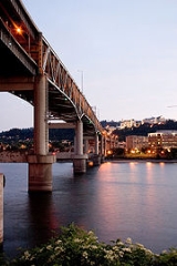
The Ross Island Bridge is a cantilever truss bridge
that spans the Willamette River
in Portland, Oregon
. It carries U.S. Route 26 (Mount Hood Highway
) across the river between southwest and southeast Portland. Although it looks like a deck arch bridge, it is the only cantilever deck truss bridge in Oregon
.
The bridge is named for its location close to Ross Island
, an island in the Willamette River which measures about one-and-a-half by one miles. The bridge is about 800 feet (250 m) north of the island and does not connect with, nor does it provide access to Ross Island.
The bridge was part of the unprecedented period of bridge building in Portland during the 1920s. It was opened on December 21, 1926 at a cost of $1.9 million. The bridge was designed by famed engineer Gustav Lindenthal
.
There is a pedestrian walkway on the north side of the bridge, with no barrier between the sidewalk and the westbound right lane.
During the Great Depression
, the bank of the Willamette near the Ross Island Bridge became the site of a Hooverville
.
In 1976 ownership was transferred from Multnomah County
to the Oregon Department of Transportation
. In 2000-2001 the bridge underwent a $12.5 million renovation in which the deck was replaced, the railings were replaced and upgraded, and the drainage system and lighting were improved. During this renovation, lead paint
was discovered, causing some delays and cost overruns.
with Naito Parkway (Oregon Route 10, Pacific Highway West), as well as access to and from Arthur Street, which carries US 26 towards Interstate 405
. (Until around 2005, US 26 went north on Naito Parkway and through the south side of downtown Portland.) Access is also provided to and from the north end of Oregon Route 43 (Macadam Avenue - Oswego Highway), which runs next to Interstate 5 as frontage road
s, and allows for access to and from I-5 via slip ramps and U-turns.
The pedestrian walkway comes off the north side parallel to the ramp to Kelly Avenue (leading to Arthur Street), running to the intersection of Kelly Avenue and Porter Street.
, built to near-freeway standards; just to the north it passes over a railroad on the twin Martin Luther King, Jr. Viaduct and Grand Avenue Viaduct. There is a direct ramp from US 26 east to Route 99E south, but no northbound access. Likewise, there is access from Route 99E north to the bridge (via Woodward Street and 8th Avenue), but traffic from Route 99E south must exit at Mill Street, about 1/2 mile (1 km) to the north, and head down Division Street, 11th Avenue and Milwaukie Avenue to US 26. This same movement is done to reach US 26 east; US 26 west however has direct access to Route 99E north via 9th Avenue and Woodward Street. A fourth direct ramp runs from Route 99E north to US 26 east.
The pedestrian walkway simply becomes the north sidewalk of Powell Boulevard, a major street.
Cantilever bridge
A cantilever bridge is a bridge built using cantilevers, structures that project horizontally into space, supported on only one end. For small footbridges, the cantilevers may be simple beams; however, large cantilever bridges designed to handle road or rail traffic use trusses built from...
that spans the Willamette River
Willamette River
The Willamette River is a major tributary of the Columbia River, accounting for 12 to 15 percent of the Columbia's flow. The Willamette's main stem is long, lying entirely in northwestern Oregon in the United States...
in Portland, Oregon
Portland, Oregon
Portland is a city located in the Pacific Northwest, near the confluence of the Willamette and Columbia rivers in the U.S. state of Oregon. As of the 2010 Census, it had a population of 583,776, making it the 29th most populous city in the United States...
. It carries U.S. Route 26 (Mount Hood Highway
Mount Hood Highway
The Mount Hood Highway No. 26 is the Oregon Department of Transportation's designation for a 93.84-mile highway from Portland east around the south side of Mount Hood and north via Bennett Pass to Hood River. It is marked as U.S...
) across the river between southwest and southeast Portland. Although it looks like a deck arch bridge, it is the only cantilever deck truss bridge in Oregon
Oregon
Oregon is a state in the Pacific Northwest region of the United States. It is located on the Pacific coast, with Washington to the north, California to the south, Nevada on the southeast and Idaho to the east. The Columbia and Snake rivers delineate much of Oregon's northern and eastern...
.
The bridge is named for its location close to Ross Island
Ross Island (Oregon)
Ross Island is the main island of a four-island cluster in the Willamette River in Portland, Oregon, in the United States. The islands, covering a total of about , are owned mainly by Ross Island Sand and Gravel , which mined them extensively between 1926 and 2001...
, an island in the Willamette River which measures about one-and-a-half by one miles. The bridge is about 800 feet (250 m) north of the island and does not connect with, nor does it provide access to Ross Island.
The bridge was part of the unprecedented period of bridge building in Portland during the 1920s. It was opened on December 21, 1926 at a cost of $1.9 million. The bridge was designed by famed engineer Gustav Lindenthal
Gustav Lindenthal
Gustav Lindenthal was a civil engineer who designed the Hell Gate Bridge among other bridges.Lindenthal's work was greatly affected by his pursuit for perfection and his love of art. His structures not only serve the purpose they were designed for, but are aesthetically pleasing to the public eye...
.
There is a pedestrian walkway on the north side of the bridge, with no barrier between the sidewalk and the westbound right lane.
During the Great Depression
Great Depression
The Great Depression was a severe worldwide economic depression in the decade preceding World War II. The timing of the Great Depression varied across nations, but in most countries it started in about 1929 and lasted until the late 1930s or early 1940s...
, the bank of the Willamette near the Ross Island Bridge became the site of a Hooverville
Hooverville
A 'Hooverville' was the popular name for shanty towns built by homeless people during the Great Depression. They were named after the President of the United States at the time, Herbert Hoover, because he allegedly let the nation slide into depression...
.
In 1976 ownership was transferred from Multnomah County
Multnomah County, Oregon
Multnomah County is one of 36 counties in the U.S. state of Oregon. Though smallest in area, it is the most populous as its county seat, Portland, is the state's largest city...
to the Oregon Department of Transportation
Oregon Department of Transportation
The Oregon Department of Transportation is a department of the state government of the U.S. state of Oregon responsible for systems of transportation. It was first established in 1969. It had been preceded by the Oregon State Highway Department which, along with the Oregon State Highway...
. In 2000-2001 the bridge underwent a $12.5 million renovation in which the deck was replaced, the railings were replaced and upgraded, and the drainage system and lighting were improved. During this renovation, lead paint
Lead paint
Lead paint or lead-based paint is paint containing lead, a heavy metal, that is used as pigment, with lead chromate and lead carbonate being the most common. Lead is also added to paint to speed drying, increase durability, retain a fresh appearance, and resist moisture that causes corrosion...
was discovered, causing some delays and cost overruns.
West approach
The west end of the bridge has a full interchangeInterchange (road)
In the field of road transport, an interchange is a road junction that typically uses grade separation, and one or more ramps, to permit traffic on at least one highway to pass through the junction without directly crossing any other traffic stream. It differs from a standard intersection, at which...
with Naito Parkway (Oregon Route 10, Pacific Highway West), as well as access to and from Arthur Street, which carries US 26 towards Interstate 405
Interstate 405 (Oregon)
Interstate 405 is a short Interstate Highway in Portland, Oregon. It forms a loop from Interstate 5 that travels through downtown Portland west of the Willamette River.-Route description:...
. (Until around 2005, US 26 went north on Naito Parkway and through the south side of downtown Portland.) Access is also provided to and from the north end of Oregon Route 43 (Macadam Avenue - Oswego Highway), which runs next to Interstate 5 as frontage road
Frontage road
A frontage road is a non-limited access road running parallel to a higher-speed road, usually a freeway, and feeding it at appropriate points of access...
s, and allows for access to and from I-5 via slip ramps and U-turns.
The pedestrian walkway comes off the north side parallel to the ramp to Kelly Avenue (leading to Arthur Street), running to the intersection of Kelly Avenue and Porter Street.
East approach
At the east end of the bridge, US 26 becomes Powell Boulevard as it passes over Oregon Route 99E (Pacific Highway East). Route 99E is a high-speed arterial roadArterial road
An arterial road, or arterial thoroughfare, is a high-capacity urban road. The primary function of an arterial road is to deliver traffic from collector roads to freeways, and between urban centres at the highest level of service possible. As such, many arteries are limited-access roads, or feature...
, built to near-freeway standards; just to the north it passes over a railroad on the twin Martin Luther King, Jr. Viaduct and Grand Avenue Viaduct. There is a direct ramp from US 26 east to Route 99E south, but no northbound access. Likewise, there is access from Route 99E north to the bridge (via Woodward Street and 8th Avenue), but traffic from Route 99E south must exit at Mill Street, about 1/2 mile (1 km) to the north, and head down Division Street, 11th Avenue and Milwaukie Avenue to US 26. This same movement is done to reach US 26 east; US 26 west however has direct access to Route 99E north via 9th Avenue and Woodward Street. A fourth direct ramp runs from Route 99E north to US 26 east.
The pedestrian walkway simply becomes the north sidewalk of Powell Boulevard, a major street.
See also
- List of crossings of the Willamette River
- Nicknames of Portland, Oregon#Bridgetown
- Transportation in Portland, Oregon#Bridges
External links
- Library of CongressLibrary of CongressThe Library of Congress is the research library of the United States Congress, de facto national library of the United States, and the oldest federal cultural institution in the United States. Located in three buildings in Washington, D.C., it is the largest library in the world by shelf space and...
, photos of a Hooverville near the Ross Island Bridge