
Canton Viaduct
Encyclopedia
Canton Viaduct is the oldest blind arcade
cavity wall
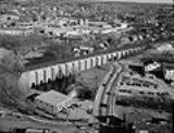
bridge in the world and it was the longest and tallest railroad bridge ever built when it was completed in 1835. It is the last surviving bridge of its kind and has been in continuous service for years; it now carries high-speed passenger and freight rail service. This hollow bridge in Canton, Massachusetts
(USA) was built in 1834-35 for the Boston and Providence Railroad Corporation (B&P). The bridge is 0.3 miles (0.5 km) south of Canton Junction
and originally provided mainline service between Boston, Massachusetts, and Providence, Rhode Island. It was the final link to be built on the 41-mile railroad between the two cities. The viaduct is located on Amtrak
's Northeast Corridor
at milepost 213.74, reckoned from Pennsylvania Station in New York City, and at the Massachusetts Bay Transportation Authority
's (MBTA) milepost 15.35, reckoned from South Station in Boston.
 The Canton Viaduct was erected in 1835 by the B&P, one of the first New England railroads, shortly after its 1831 founding. Thomas B. Wales, one of the original families of Boston, and owner of the T.B. Wales & Co. Shipping Company, was the first president of the B&P, The Taunton Branch Railroad, as well as the Western Railroad Corporation. Due to his friendship with prominent New England families, including the Revere family, they were able to bring the Canton Viaduct to fruition. The T.B. Wales & Co. clipper ships
brought raw materials for manufacturing companies from its dock (Wales Wharf) and Counting House (Long Wharf) to various areas in New England. Without the influence of individuals such as Thomas B. Wales, Joseph Warren Revere
, owner of the Revere Copper Company
and major stockholders (most of whom were Board members), the Canton Viaduct would not have been built. There were better routes through other towns for the location of the railroad line from Boston to Providence. However, building the railroad through Canton placed the line close to Paul Revere's Copper Rolling Mill, where a half mile spur (using strap rails
and horse power) connected the mill to Canton Junction and undoubtedly gave a boost to Revere's copper business. The other influencing factor that caused the Canton Viaduct to be built was a fatal accident in 1832 on the Granite Railroad, which used inclined planes to cross a valley. The original plans called for the use of inclined planes to cross the Canton River Valley
(Canton Dale), but they were changed after the inclined plane accident, and a bridge was built instead. This unique bridge was designed by a U.S. Army Corps of Engineers Officer and West Point graduate - Captain William Gibbs McNeill. He was assisted by engineers, Major George Washington Whistler
(McNeill's brother-in-law), Major General Isaac Ridgeway Trimble and General William Raymond Lee. The bridge was built by the Dodd & Baldwin
company from Pennsylvania. Around this time, Russia was interested in building railroads. Tsar Nicholas I sent workmen to draw extensive diagrams of the Canton Viaduct. He later summoned Whistler to Russia as a consulting engineer to design the Moscow–Saint Petersburg Railway, on which two bridges were modeled after the Canton Viaduct. A scale model bridge of similar design is on display at the Oktyabrsky Railroad Museum in St. Petersburg.
stone, supporting a train deck about 60 feet (18.3 m) above the Canton River
, the east branch (tributary
) of the Neponset River
. The stream pool
passes through six semi-circular portals
in the bridge, flowing to a waterfall about 50 feet downstream.
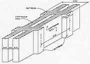
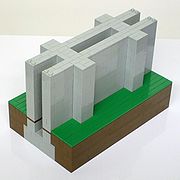
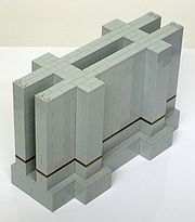
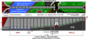
The bridge is an archetype due to its blind arcade
and cavity wall
combination, the first and possibly only time these two elements were used in bridge design. The structure is often referred to as a "multiple arch" bridge, but the deck arches are not the primary support system. Although the deck arches appear to extend through the bridge to the deck arches on the opposite side, they do not; each deck arch is independent and only four feet deep. The only arches to penetrate the walls are six river portals and two roadway portals. Since bridges are classified by their primary support system, the Canton Viaduct is more accurately described as a blind arcade cavity wall. The walls support the majority of the deck with stone slabs spanning the cavities. The deck arches only support the outer limits of the deck (beyond the walls); they are tied to the walls but do not penetrate them.
The coping
is supported by 42 segmental deck arch
es (21 on each side) that join the tops of 22 buttress
es tied to the continuous walls internally and externally. The walls are five feet thick with a four foot gap between them joined with occasional tie stones. More construction details are available in the original specifications. When the bridge had a single set of tracks, the rails were placed directly over the walls as the cavity's width is less than standard gauge
. When the bridge was double tracked in 1860, the inside rails were placed directly over the walls and the outside rails were over the deck arches. The Thomas Viaduct
(Maryland, 1835) and Starrucca Viaduct
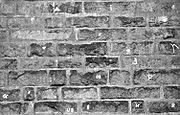
(Pennsylvania, 1847) are classic examples of multiple arch viaducts, as their primary support system consists of semi-circular arches on piers without any walls.
) of granite, which weighs approximately 66000000 pounds (33,000 ST) prior to its concrete redecking in 1993. Each stone has a Mason's mark
to identify who cut the stone. Each course is 22" - 24" high and laid in a pattern closely resembling a Flemish bond
. Exterior stone for the walls, buttresses, wing wall
abutment
s, portals, deck arches, coping, parapets and the foundation stone are riebeckite
granite mined from Moyles quarry
(a.k.a. Canton Viaduct Quarry) located on the westerly slope of Rattlesnake Hill in Sharon, Massachusetts; now part of Borderland State Park
. This type of granite was chosen because it does not stain as it weathers, but retains its original color. Interior stone for the foundation, walls, buttresses, wing wall abutments, binders, stiles, deck, Dedication Stone and capstone are of a different type of granite mined from Dunbar's quarry in Canton, Massachusetts.
Bridge
Deck
In 1840 the road under the viaduct was known as "the street leading from Neponset Bank by Elisha White's to near Joseph Downes. Sometime after, it was known as "Rail Road St.", and in 1881, it was finally named "Neponset St." after the river. It serves as a major artery in Canton connecting its main street (Washington St.) to Interstate 95
.
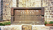
to mark the 175th anniversary of the Viaduct, many of the operative stonemasons who worked on the Viaduct were also Freemasons from local area lodges. In addition to the workmen, the majority of the B&P's Board of Directors were Freemasons, including Thomas B. Wales and Joseph W. Revere.
The foundation stone was laid on Sunday, April 20, 1834 with a Masonic Builders' rites
ceremony. Following to Masonic tradition, the foundation stone was located in the northeast corner of the structure.
 The Canton Viaduct cost US$93,000 to build in 1835, which equates to $2.4 Million in 2009 dollars. Construction took 15 months, 8 days from laying of the foundation stone on April 20, 1834 to completion on July 28, 1835. An excerpt from an article in the Providence Journal on June 6, 1835 describes the bridge prior to its completion. As reported by the Boston Advertiser and the Providence Journal. "Whistler" was the first engine to pass over the entire length of the road. The engine was built by Robert Stephenson
in 1833 in England and named by William Gibbs McNeill in honor of his brother-in-law George Washington Whistler. The trip from Boston to Providence cost $2 one way.
The first and last buttresses (adjacent to the wing wall abutments) are only 3' wide, all the other buttresses are 5'-6" wide. The wing wall abutments are 25' wide where they meet the bridge; they are curved and stepped and were built by William Otis
using his first steam shovel
. From the top of the wing walls to mid way down the stones are of 2' wide; from mid way down to the bottom of the wing walls the stones are 4' wide.
The bridge was "substantially complete" in June 1835 from various accounts of horse-drawn cars passing over it during that time. The bridge was built before the advent of construction safety equipment such as hard hats and fall arrest
devices. Surprisingly, no deaths were recorded during the construction, but deaths have occurred at the bridge since completion; mainly from people crossing the bridge while trains passed in opposite directions. Charlie, the old white horse who had hauled the empty railcars back to Sharon, Massachusetts (4 miles), was placed upon the flat car and hauled across the viaduct by the workers, thus becoming the first "passenger" to cross the structure.
Aside from seasonal vegetation control and occasional graffiti removal, the bridge requires no maintenance other than periodic bridge inspections from Amtrak.
There are examples of Fibonacci numbers and golden ratio
s in the Canton Viaduct:
 The capstone
was laid in the south end of the west parapet
. This stone sat atop the Dedication Stone and it was the last stone to be laid in the bridge. .
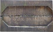
The Dedication Stone is actually two stones now held together with two iron straps on each end. The overall dimensions are approximately 60" long × 36" high × 18" wide (golden ratio), and it weighs approximately 3,780 lbs. The Dedication Stone was originally topped with a 63" long × 8" high × 24" wide capstone with double bevel
ed edges, creating an irregular hexagonal profile. Due to its breaking in 1860, the Dedication Stone is about 1" shorter today than its original height. The damage obscured two directors' names, W. W. Woolsey and P. T. Jackson
. Woolsey was also a Director of the Boston & Providence Railroad & Transportation Co. (B&P RR&T Co.) in Rhode Island (incorporated May 10, 1834) which owned the Rhode Island portion of the Boston and Providence rail line. The B&P RR&T Co. merged with the B&P on June 1, 1853.
width (56½"). The troughs contained baulks
or longitudinal sleepers and were part of the original construction. The baulks supported the rails with transoms between to maintain the gauge. A 1910 photo taken atop the viaduct shows dirt between the cross ties and tracks, so this material may have been used before traditional gravel ballast.
Baulks were used to support strap rails or bridge rail. These early rails
would have been replaced with flanged T-rails by 1840. These photos show baulks at Canton Junction in 1871. An 1829 report from the Massachusetts Board of Directors of Internal Improvements describes how the railroad from Boston to Providence was to be built. The report states, "It consists of one pair of tracks composed of long blocks of granite, about one foot square, resting upon a foundation wall extending to the depth of 2½' below the surface of the ground, and 2' wide at the bottom". The report also calls for using horse drawn wagons and carriages at 3 MPH on the rail line, not steam locomotives.
Planning (B&P)
Preconstruction (unknown)
Construction
Post Construction
 Spillway
Dam at Neponset St. - a.k.a. Canton Viaduct Falls impounds Mill Pond. It is a weir
or low head dam that is owned by the MBTA. The 16' high by 90' long granite dam was built in 1900 and currently (2009) averages 78 cubic feet/second annual discharge. Water power was supplied to nearby businesses via water wheel
from the canal starting at the waterfall's enclosed plunge pool
and continuing about 200' under the Neponset St. bridge. There were also two channels located between the viaduct and the waterfall (one on each side) referred to as sluice
s, headraces and flume
s in various maps. They were filled in sometime after 1937 (U.S. Army Corps of Engineers National Inventory of Dams No. MA03106).
Project challenges - It was necessary to maintain the historic fabric of the structure so all work was consistent with the Secretary of the Interior's Standards for Treatment of Historic Structures. The viaduct is located within Massachusetts DCR's
Fowl Meadow and Ponkapoag Bog ACEC(Map Tile #7g) so protecting endangered species in the nearby wildlife refuge presented a challenge. Working in and over the Canton River required extensive permitting and close monitoring by environmental groups. The project was also located in a designated National Environmental Study Area.
An excerpt from the September 1998 Railway Track & Structures article reads, "It was initially believed that the top of the viaduct was composed of solid granite blocks (originally carrying a single track). After the track and ballast were removed from the structure, troughs were discovered recessed into the granite capstones. The 18" deep troughs ran the entire length of the viaduct and were spaced approximately 56½" apart (standard railroad gauge). In some locations, the trough contained a solid piece of oak, including some abandoned spikes. It is believed the troughs held wooden sleepers for the original single track railroad. These loose materials were removed from the deck, and lean concrete was placed to fill the voids. Archival photographs of the sleepers were taken and their remnants will be turned over to the local historical commission. At the approaches to the viaduct, a series of granite walls were uncovered running perpendicular to the tracks. These walls were approximately 7' on center, and it was thought that they might have carried a timber approach structure. The locations of the walls conflicted with new abutments for the PPC beams, and they made it difficult to install sheet piling for the contractor's support of excavation system. The walls were left in place undisturbed beneath the new track structure. HDR, Inc.
redesigned the abutments to minimize their depths, eliminate the conflicts and reduce the loading of the temporary support of excavation system."
When the railroad was complete except for the viaduct, trains ran to the bridge abutments where passengers would exit and descend the embankment. Passengers crossed the river on a hand-operated cable ferry
, boarded horse drawn carriages on a temporary wagonway
to cross the valley, then ascended the embankment to board a waiting train at the opposite abutment. The parallel walls at the abutments are believed to have supported the temporary (covered) train platforms to which wooden staircases were attached. These wooden staircases led from the train platforms to stone abutment staircases (with railings) for passengers to descended to the valley floor. A photo from 1871 may have captured one of those walls (bottom left), at the north end, west side of the viaduct. The parallel walls may have also served as foundations for the guard houses during World War II.
Many coping stones were discarded during the deck replacement project; they were placed in the field behind the viaduct. Some Canton residents recovered smaller stones from the massive pile before it was hauled off to an unknown destination. Portland Cement Association's Historic Canton Viaduct case study has more project details.
Three interior inspections were performed in the winter by two structural engineers using rock climbing equipment to scale the interior walls. The inspectors noticed small, insignificant cracks in the walls and larger cracks in the deck stones that eventually led to the deck being replaced. The stones of the viaduct were placed in such a way as to allow interior access at just three locations. Between the walls occasional tie stones connect the walls together. Some tie stones have large, loose stones placed on them to support work planks. The local film crew noticed rock crystal formation taking place, associated with the moist air inside and a rotting wooden platform. They also noticed some thin wood or iron pieces connecting the walls. It is unknown if these iron pieces or the platforms were used during construction or inspection. Stone stiles protrude into the airspace but do not reach the opposite side. The stiles were used to support work planks instead of traditional scaffolding
due to the narrow space between the walls.
Over the years the town of Canton has proposed the addition of pedestrian portals to provide safe passage under the viaduct but bridge owners have consistently rejected these proposals.
In a letter to Canton's Board of Selectmen on February 27, 2002, former Police Chief Peter Bright noted that Massachusetts Emergency Management Agency
training for worst-case situations highlights the destruction of the Canton Viaduct for its disruption of the national railroad system; the Federal Government also considers the bridge a high-risk target.
 The Canton Viaduct is a congested, high volume traffic area with an average of 16,400 motor vehicles passing under the bridge each day. There are many safety issues with the Canton Viaduct and surrounding area:
A Curb Cuts/Sidewalk Variance was submitted by the town of Canton to the Massachusetts Department of Public Safety's Architectural Access Board in February 2000 requesting the exclusion of a wheelchair ramp and replacement of a paved sidewalk with gravel to actively discourage pedestrian travel under the viaduct. The board's decision was to grant the variance due to potential vehicle/pedestrian conflicts. The wheelchair ramp was not added; however, the paved sidewalk was not replaced with gravel as approved. The board also ordered, and the town agreed, to post signage on both sides of the viaduct indicating the area is dangerous to all pedestrians; this signage was not installed.
The lack of sidewalks, crosswalks, signage and lighting, plus the narrow roadway, limited lines of sight and low clearance makes the Canton Viaduct a dangerous crossing for pedestrians and vehicles.
In June 2004 the town of Canton developed a Master Plan that identifies what should be preserved and enhanced to meet evolving needs and improve the quality of life. Items from the Master Plan related to Canton Viaduct include:
Some of these items have been implemented and others are in the planning stages.
Blind arcade
A blind arcade is an arcade that is composed of a series of arches that has no actual openings and that is applied to the surface of a wall as a decorative element: i.e. the arches are not windows or openings but are part of the masonry face. It is designed as an ornamental architectural element,...
cavity wall
Cavity wall
Cavity walls consist of two 'skins' separated by a hollow space . The skins are commonly masonry such as brick or concrete block. Masonry is an absorbent material, and therefore will slowly draw rainwater or even humidity into the wall. The cavity serves as a way to drain this water back out...
bridge in the world and it was the longest and tallest railroad bridge ever built when it was completed in 1835. It is the last surviving bridge of its kind and has been in continuous service for years; it now carries high-speed passenger and freight rail service. This hollow bridge in Canton, Massachusetts
Canton, Massachusetts
Canton is a town in Norfolk County, Massachusetts, United States. The population was 21,561 at the 2010 census. Canton is part of Greater Boston, about 15 miles southwest of downtown Boston.- History :...
(USA) was built in 1834-35 for the Boston and Providence Railroad Corporation (B&P). The bridge is 0.3 miles (0.5 km) south of Canton Junction
Canton Junction (MBTA station)
Canton Junction is a railway station on the MBTA Commuter Rail's Providence/Stoughton line, located a few hundred yards north of the Canton Viaduct. At Canton Junction the two branches of the Providence/Stoughton Line split, one going to T. F...
and originally provided mainline service between Boston, Massachusetts, and Providence, Rhode Island. It was the final link to be built on the 41-mile railroad between the two cities. The viaduct is located on Amtrak
Amtrak
The National Railroad Passenger Corporation, doing business as Amtrak , is a government-owned corporation that was organized on May 1, 1971, to provide intercity passenger train service in the United States. "Amtrak" is a portmanteau of the words "America" and "track". It is headquartered at Union...
's Northeast Corridor
Northeast Corridor
The Northeast Corridor is a fully electrified railway line owned primarily by Amtrak serving the Northeast megalopolis of the United States from Boston in the north, via New York to Washington, D.C. in the south, with branches serving other cities...
at milepost 213.74, reckoned from Pennsylvania Station in New York City, and at the Massachusetts Bay Transportation Authority
Massachusetts Bay Transportation Authority
The Massachusetts Bay Transportation Authority, often referred to as the MBTA or simply The T, is the public operator of most bus, subway, commuter rail and ferry systems in the greater Boston, Massachusetts, area. Officially a "body politic and corporate, and a political subdivision" of the...
's (MBTA) milepost 15.35, reckoned from South Station in Boston.
Inception
Clipper
A clipper was a very fast sailing ship of the 19th century that had three or more masts and a square rig. They were generally narrow for their length, could carry limited bulk freight, small by later 19th century standards, and had a large total sail area...
brought raw materials for manufacturing companies from its dock (Wales Wharf) and Counting House (Long Wharf) to various areas in New England. Without the influence of individuals such as Thomas B. Wales, Joseph Warren Revere
Joseph Warren Revere
Joseph Warren Revere was the co-founder of the Revere Copper Company in Canton, Massachusetts in 1801 with his father, Paul Revere. He became president of the company when his father retired in 1811. He was largely responsible for the success of the business, in which he pioneered the technique of...
, owner of the Revere Copper Company
Revere Copper Company
The Revere Copper Company was North America's first rolled copper mill. It was started by Paul Revere in 1801 in Canton, Massachusetts and developed a commercially viable process for manufacturing copper sheets....
and major stockholders (most of whom were Board members), the Canton Viaduct would not have been built. There were better routes through other towns for the location of the railroad line from Boston to Providence. However, building the railroad through Canton placed the line close to Paul Revere's Copper Rolling Mill, where a half mile spur (using strap rails
Rail profile
The rail profile is the cross sectional shape of a railway rail, perpendicular to the length of the rail.In all but very early cast iron rails, a rail is hot rolled steel of a specific cross sectional profile designed for use as the fundamental component of railway track.Unlike some other uses of...
and horse power) connected the mill to Canton Junction and undoubtedly gave a boost to Revere's copper business. The other influencing factor that caused the Canton Viaduct to be built was a fatal accident in 1832 on the Granite Railroad, which used inclined planes to cross a valley. The original plans called for the use of inclined planes to cross the Canton River Valley
Valley
In geology, a valley or dale is a depression with predominant extent in one direction. A very deep river valley may be called a canyon or gorge.The terms U-shaped and V-shaped are descriptive terms of geography to characterize the form of valleys...
(Canton Dale), but they were changed after the inclined plane accident, and a bridge was built instead. This unique bridge was designed by a U.S. Army Corps of Engineers Officer and West Point graduate - Captain William Gibbs McNeill. He was assisted by engineers, Major George Washington Whistler
George Washington Whistler
George Washington Whistler was a prominent American railroad engineer in the first half of the 19th century....
(McNeill's brother-in-law), Major General Isaac Ridgeway Trimble and General William Raymond Lee. The bridge was built by the Dodd & Baldwin
Dodd & Baldwin
Dodd & Baldwin constructed the Canton Viaduct in 1834-1835 for the Boston & Providence Railroad Corporation. The Pennsylvania firm was established by cousins Ira Dodd and Caleb Dodd Baldwin....
company from Pennsylvania. Around this time, Russia was interested in building railroads. Tsar Nicholas I sent workmen to draw extensive diagrams of the Canton Viaduct. He later summoned Whistler to Russia as a consulting engineer to design the Moscow–Saint Petersburg Railway, on which two bridges were modeled after the Canton Viaduct. A scale model bridge of similar design is on display at the Oktyabrsky Railroad Museum in St. Petersburg.
Classification
The bridge resembles an ancient city wall built from rusticatedRustication (architecture)
thumb|upright|Two different styles of rustication in the [[Palazzo Medici-Riccardi]] in [[Florence]].In classical architecture rustication is an architectural feature that contrasts in texture with the smoothly finished, squared block masonry surfaces called ashlar...
stone, supporting a train deck about 60 feet (18.3 m) above the Canton River
Canton River
The Canton River cuts through downtown Canton, Massachusetts tracing down Washington and Neponset Streets , and continues down Walpole Street, and is a tributary of the Neponset River, with a few tributaries on the side. It is also called the East Branch [of the] Neponset River....
, the east branch (tributary
Tributary
A tributary or affluent is a stream or river that flows into a main stem river or a lake. A tributary does not flow directly into a sea or ocean...
) of the Neponset River
Neponset River
The Neponset River is a river in eastern Massachusetts in the United States. The headwaters of the Neponset are at the Neponset Reservoir in Foxborough, near the Gillette Stadium...
. The stream pool
Stream pool
A stream pool, in hydrology, is a stretch of a river or stream in which the water depth is above average and the water velocity is quite below average.-Formation:...
passes through six semi-circular portals
Portal (architecture)
Portal is a general term describing an opening in the walls of a building, gate or fortification, and especially a grand entrance to an important structure. Doors, metal gates or portcullis in the opening can be used to control entry or exit. The surface surrounding the opening may be made of...
in the bridge, flowing to a waterfall about 50 feet downstream.
The bridge is an archetype due to its blind arcade
Blind arcade
A blind arcade is an arcade that is composed of a series of arches that has no actual openings and that is applied to the surface of a wall as a decorative element: i.e. the arches are not windows or openings but are part of the masonry face. It is designed as an ornamental architectural element,...
and cavity wall
Cavity wall
Cavity walls consist of two 'skins' separated by a hollow space . The skins are commonly masonry such as brick or concrete block. Masonry is an absorbent material, and therefore will slowly draw rainwater or even humidity into the wall. The cavity serves as a way to drain this water back out...
combination, the first and possibly only time these two elements were used in bridge design. The structure is often referred to as a "multiple arch" bridge, but the deck arches are not the primary support system. Although the deck arches appear to extend through the bridge to the deck arches on the opposite side, they do not; each deck arch is independent and only four feet deep. The only arches to penetrate the walls are six river portals and two roadway portals. Since bridges are classified by their primary support system, the Canton Viaduct is more accurately described as a blind arcade cavity wall. The walls support the majority of the deck with stone slabs spanning the cavities. The deck arches only support the outer limits of the deck (beyond the walls); they are tied to the walls but do not penetrate them.
The coping
Coping (architecture)
Coping , consists of the capping or covering of a wall.A splayed or wedge coping slopes in a single direction; a saddle coping slopes to either side of a central high point....
is supported by 42 segmental deck arch
Arch
An arch is a structure that spans a space and supports a load. Arches appeared as early as the 2nd millennium BC in Mesopotamian brick architecture and their systematic use started with the Ancient Romans who were the first to apply the technique to a wide range of structures.-Technical aspects:The...
es (21 on each side) that join the tops of 22 buttress
Buttress
A buttress is an architectural structure built against or projecting from a wall which serves to support or reinforce the wall...
es tied to the continuous walls internally and externally. The walls are five feet thick with a four foot gap between them joined with occasional tie stones. More construction details are available in the original specifications. When the bridge had a single set of tracks, the rails were placed directly over the walls as the cavity's width is less than standard gauge
Standard gauge
The standard gauge is a widely-used track gauge . Approximately 60% of the world's existing railway lines are built to this gauge...
. When the bridge was double tracked in 1860, the inside rails were placed directly over the walls and the outside rails were over the deck arches. The Thomas Viaduct
Thomas Viaduct
The Thomas Viaduct spans the Patapsco River and Patapsco Valley between Relay and Elkridge, Maryland, USA. It is the first multi-span masonry railroad bridge in the United States to be built on a curve...
(Maryland, 1835) and Starrucca Viaduct
Starrucca Viaduct
Starrucca Viaduct is a stone arch bridge that spans Starrucca Creek near Lanesboro, Pennsylvania, in the United States. At the time of its construction, the bridge was thought to be the most expensive railway bridge in the world, at a cost of $320,000 , and it was the largest stone rail viaduct in...
(Pennsylvania, 1847) are classic examples of multiple arch viaducts, as their primary support system consists of semi-circular arches on piers without any walls.
Materials
The Canton Viaduct contained 14,483 cubic feet (15,800 perchesPerch (unit of measure)
A perch is as a unit of measurement used for length, area, and volume in a number of systems of measurement. Its name derives from the Ancient Roman unit, the pertica.-Origin:...
) of granite, which weighs approximately 66000000 pounds (33,000 ST) prior to its concrete redecking in 1993. Each stone has a Mason's mark
Mason's mark
A mason's mark is a symbol often found on dressed stone in buildings and other public structures.-In stonemasonry:Scottish rules issued in 1598 stated that on admission to the guild, every mason had to enter his name and his mark in a register....
to identify who cut the stone. Each course is 22" - 24" high and laid in a pattern closely resembling a Flemish bond
Brickwork
Brickwork is masonry produced by a bricklayer, using bricks and mortar to build up brick structures such as walls. Brickwork is also used to finish corners, door, and window openings, etc...
. Exterior stone for the walls, buttresses, wing wall
Wing wall
A wing wall is a smaller wall attached or next to a larger wall or structure.-Bridges:In a bridge, the wing walls are adjacent to the abutments and act as retaining walls.They are generally constructed of the same material as those of abutments...
abutment
Abutment
An abutment is, generally, the point where two structures or objects meet. This word comes from the verb abut, which means adjoin or having common boundary. An abutment is an engineering term that describes a structure located at the ends of a bridge, where the bridge slab adjoins the approaching...
s, portals, deck arches, coping, parapets and the foundation stone are riebeckite
Riebeckite
Riebeckite is a sodium-rich member of the amphibole group of silicate minerals, chemical formula [][Na2][32][2|Si8O22]. It forms a series with magnesioriebeckite. It crystallizes in the monoclinic system, usually as long prismatic crystals showing a diamond-shaped cross section, but also in...
granite mined from Moyles quarry
Quarry
A quarry is a type of open-pit mine from which rock or minerals are extracted. Quarries are generally used for extracting building materials, such as dimension stone, construction aggregate, riprap, sand, and gravel. They are often collocated with concrete and asphalt plants due to the requirement...
(a.k.a. Canton Viaduct Quarry) located on the westerly slope of Rattlesnake Hill in Sharon, Massachusetts; now part of Borderland State Park
Borderland State Park
Borderland is one of Massachusetts' state parks, located in the towns of Easton and Sharon. The main entrance and visitor center are located in Easton. The area was listed on the National Register of Historic Places as Borderland Historic District in 1997.In 1906, Oakes Ames, a Harvard botanist...
. This type of granite was chosen because it does not stain as it weathers, but retains its original color. Interior stone for the foundation, walls, buttresses, wing wall abutments, binders, stiles, deck, Dedication Stone and capstone are of a different type of granite mined from Dunbar's quarry in Canton, Massachusetts.
Bridge
- Granite (two types from two local quarries)
- Mortar (except interior of the wing wall abutments which were laid dry)
- Reinforced concrete (roadway portal and deck arches)
Deck
- Reinforced concrete (new deck and cross ties)
- Waterproof cement (on coping)
- Iron (fence/railing and rails)
- Galvanized steel (walkway gratingGratingA grating is any regularly spaced collection of essentially identical, parallel, elongated elements. Gratings usually consist of a single set of elongated elements, but can consist of two sets, in which case the second set is usually perpendicular to the first...
and catenary systemOverhead linesOverhead lines or overhead wires are used to transmit electrical energy to trams, trolleybuses or trains at a distance from the energy supply point...
) - Rubber (ballast mats under tracks for noise reduction)
- Lean concrete (longitudinal troughs fill)
- Crushed granite (track ballastTrack ballastTrack ballast forms the trackbed upon which railway sleepers or railroad ties are laid. It is packed between, below, and around the ties. It is used to facilitate drainage of water, to distribute the load from the railroad ties, and also to keep down vegetation that might interfere with the track...
) - Wood (original longitudinal sleepersBaulk roadBaulk road is the name given to a type of railway track or 'rail road' that is formed using rails carried on continuous timber bearings, as opposed to the more familiar 'cross-sleeper' track that uses closely spaced sleepers or ties to give intermittent support to taller rails...
, cross ties, fence/railing and curb)
Location
The majority of the viaduct is over land (71%), while 29% is over water. In addition to the six river portals, one roadway portal was originally provided. The distance between the buttresses at this section is wider than all the other sections of the bridge. The overall length is 615 feet (187.5 m) with a one degree horizontal curve that creates two concentric arcs. This makes the west wall slightly shorter than the east wall producing a slight keystone shape in the cavities. Originally unnamed, it was referred to as "the stone bridge" and "the viaduct at Canton" before it was eventually named after the town.In 1840 the road under the viaduct was known as "the street leading from Neponset Bank by Elisha White's to near Joseph Downes. Sometime after, it was known as "Rail Road St.", and in 1881, it was finally named "Neponset St." after the river. It serves as a major artery in Canton connecting its main street (Washington St.) to Interstate 95
Interstate 95 in Massachusetts
Interstate 95 is the main highway on the East Coast of the United States, paralleling the Atlantic Ocean from Florida to Maine. The Massachusetts portion of the highway enters from the state of Rhode Island in Attleboro and travels in a northeasterly direction to the junction with Route 128 in...
.
Freemasons
According to the public flyer produced by the FreemasonsFreemasonry
Freemasonry is a fraternal organisation that arose from obscure origins in the late 16th to early 17th century. Freemasonry now exists in various forms all over the world, with a membership estimated at around six million, including approximately 150,000 under the jurisdictions of the Grand Lodge...
to mark the 175th anniversary of the Viaduct, many of the operative stonemasons who worked on the Viaduct were also Freemasons from local area lodges. In addition to the workmen, the majority of the B&P's Board of Directors were Freemasons, including Thomas B. Wales and Joseph W. Revere.
The foundation stone was laid on Sunday, April 20, 1834 with a Masonic Builders' rites
Builders' rites
Builders' rites are ceremonies attendant on the laying of foundation stones, whether ecclesiastical, masonic or otherwise, and other traditions connected with foundations or other aspects of construction....
ceremony. Following to Masonic tradition, the foundation stone was located in the northeast corner of the structure.
Construction
Robert Stephenson
Robert Stephenson FRS was an English civil engineer. He was the only son of George Stephenson, the famed locomotive builder and railway engineer; many of the achievements popularly credited to his father were actually the joint efforts of father and son.-Early life :He was born on the 16th of...
in 1833 in England and named by William Gibbs McNeill in honor of his brother-in-law George Washington Whistler. The trip from Boston to Providence cost $2 one way.
The first and last buttresses (adjacent to the wing wall abutments) are only 3' wide, all the other buttresses are 5'-6" wide. The wing wall abutments are 25' wide where they meet the bridge; they are curved and stepped and were built by William Otis
William Otis
William Otis was an American inventor of the steam shovel. Otis received a patent for his creation on February 24, 1839.In 1839, William Smith Otis, civil engineer of Philadelphia, Pennsylvania, was issued a US patent for the steam shovel for excavating and removing earth for railroads or canals....
using his first steam shovel
Steam shovel
A steam shovel is a large steam-powered excavating machine designed for lifting and moving material such as rock and soil. It is the earliest type of power shovel or excavator. They played a major role in public works in the 19th and early 20th century, being key to the construction of railroads...
. From the top of the wing walls to mid way down the stones are of 2' wide; from mid way down to the bottom of the wing walls the stones are 4' wide.
The bridge was "substantially complete" in June 1835 from various accounts of horse-drawn cars passing over it during that time. The bridge was built before the advent of construction safety equipment such as hard hats and fall arrest
Fall arrest
Fall arrest is the form of fall protection which involves the safe stopping of a person already falling. It is one of several forms of fall protection, forms which also include fall guarding and fall restraint Fall arrest is the form of fall protection which involves the safe stopping of a person...
devices. Surprisingly, no deaths were recorded during the construction, but deaths have occurred at the bridge since completion; mainly from people crossing the bridge while trains passed in opposite directions. Charlie, the old white horse who had hauled the empty railcars back to Sharon, Massachusetts (4 miles), was placed upon the flat car and hauled across the viaduct by the workers, thus becoming the first "passenger" to cross the structure.
Aside from seasonal vegetation control and occasional graffiti removal, the bridge requires no maintenance other than periodic bridge inspections from Amtrak.
There are examples of Fibonacci numbers and golden ratio
Golden ratio
In mathematics and the arts, two quantities are in the golden ratio if the ratio of the sum of the quantities to the larger quantity is equal to the ratio of the larger quantity to the smaller one. The golden ratio is an irrational mathematical constant, approximately 1.61803398874989...
s in the Canton Viaduct:
- The inscription on the back of the Dedication Stone is recessed into an elongated octagon.
- The original roadway portal was built through the eighth cavity from the south end and the concrete roadway portal was built through the thirteenth cavity from the north end.
- The rise of the original roadway portal is 8 rows and the rise of each deck arch is 3 rows.
- There are 5 voussoirVoussoirA voussoir is a wedge-shaped element, typically a stone, used in building an arch or vault.Although each unit in an arch or vault is a voussoir, two units are of distinct functional importance: the keystone and the springer. The keystone is the center stone or masonry unit at the apex of an arch. A...
s in each arch row (depth) of the original roadway portal and river portals. - There are 21 deck arches on each side of the bridge and 21 voussoirs in each deck arch.
- There are 21 cavities in the bridge.
- There are 13 voussoirs in each river portal.
- There are 3 rows of stones in the Canton Viaduct monument, the bottom and middle rows have 8 stones each.
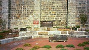
Dedication Stone
Coping (architecture)
Coping , consists of the capping or covering of a wall.A splayed or wedge coping slopes in a single direction; a saddle coping slopes to either side of a central high point....
was laid in the south end of the west parapet
Parapet
A parapet is a wall-like barrier at the edge of a roof, terrace, balcony or other structure. Where extending above a roof, it may simply be the portion of an exterior wall that continues above the line of the roof surface, or may be a continuation of a vertical feature beneath the roof such as a...
. This stone sat atop the Dedication Stone and it was the last stone to be laid in the bridge. .
The Dedication Stone is actually two stones now held together with two iron straps on each end. The overall dimensions are approximately 60" long × 36" high × 18" wide (golden ratio), and it weighs approximately 3,780 lbs. The Dedication Stone was originally topped with a 63" long × 8" high × 24" wide capstone with double bevel
Bevel
A beveled edge refers to an edge of a structure that is not perpendicular to the faces of the piece. The words bevel and chamfer overlap in usage; in general usage they are often interchanged, while in technical usage they may sometimes be differentiated as shown in the image at right.-Cutting...
ed edges, creating an irregular hexagonal profile. Due to its breaking in 1860, the Dedication Stone is about 1" shorter today than its original height. The damage obscured two directors' names, W. W. Woolsey and P. T. Jackson
Patrick Tracy Jackson
Patrick Tracy Jackson was a United States manufacturer, one of the founders of the Boston Manufacturing Company of Waltham, Massachusetts, and later a founder of the Merrimack Manufacturing Company whose developments formed the nucleus of Lowell, Massachusetts.-Biography:He was born in...
. Woolsey was also a Director of the Boston & Providence Railroad & Transportation Co. (B&P RR&T Co.) in Rhode Island (incorporated May 10, 1834) which owned the Rhode Island portion of the Boston and Providence rail line. The B&P RR&T Co. merged with the B&P on June 1, 1853.
Railroad track
During the 1993 deck renovation, two 18" deep troughs were discovered recessed into the granite deck stones running the entire length of the viaduct and spaced at standard gaugeStandard gauge
The standard gauge is a widely-used track gauge . Approximately 60% of the world's existing railway lines are built to this gauge...
width (56½"). The troughs contained baulks
Baulk road
Baulk road is the name given to a type of railway track or 'rail road' that is formed using rails carried on continuous timber bearings, as opposed to the more familiar 'cross-sleeper' track that uses closely spaced sleepers or ties to give intermittent support to taller rails...
or longitudinal sleepers and were part of the original construction. The baulks supported the rails with transoms between to maintain the gauge. A 1910 photo taken atop the viaduct shows dirt between the cross ties and tracks, so this material may have been used before traditional gravel ballast.
Baulks were used to support strap rails or bridge rail. These early rails
Rail profile
The rail profile is the cross sectional shape of a railway rail, perpendicular to the length of the rail.In all but very early cast iron rails, a rail is hot rolled steel of a specific cross sectional profile designed for use as the fundamental component of railway track.Unlike some other uses of...
would have been replaced with flanged T-rails by 1840. These photos show baulks at Canton Junction in 1871. An 1829 report from the Massachusetts Board of Directors of Internal Improvements describes how the railroad from Boston to Providence was to be built. The report states, "It consists of one pair of tracks composed of long blocks of granite, about one foot square, resting upon a foundation wall extending to the depth of 2½' below the surface of the ground, and 2' wide at the bottom". The report also calls for using horse drawn wagons and carriages at 3 MPH on the rail line, not steam locomotives.
Sequence
The Canton Viaduct was constructed in the following sequence:Planning (B&P)
- Design and specifications
Preconstruction (unknown)
- Site preparation, mobilization, surveying, excavation (using timber piling), river diversion (using cofferdamCofferdamA cofferdam is a temporary enclosure built within, or in pairs across, a body of water and constructed to allow the enclosed area to be pumped out, creating a dry work environment for the major work to proceed...
s)
Construction
- Wing wall abutments - foundations and walls (using scaffoldingScaffoldingScaffolding is a temporary structure used to support people and material in the construction or repair of buildings and other large structures. It is usually a modular system of metal pipes or tubes, although it can be from other materials...
) (Dodd & Baldwin and Otis) - Temporary train platforms and embankment staircases at abutments (B&P)
- Bridge (Dodd & Baldwin):
- Foundations - the Foundation Stone was the first stone to be laid on April 20, 1834 (northeast corner) with Masonic Builders' ritesBuilders' ritesBuilders' rites are ceremonies attendant on the laying of foundation stones, whether ecclesiastical, masonic or otherwise, and other traditions connected with foundations or other aspects of construction....
ceremony - Continuous walls, portals (using falseworkFalseworkFalsework consists of temporary structures used in construction to support spanning or arched structures in order to hold the component in place until its construction is sufficiently advanced to support itself...
) and buttresses - Cavity slabs
- Deck slabs (with longitudinal troughs) and coping
- Deck arches (using falsework)
- SpandrelSpandrelA spandrel, less often spandril or splaundrel, is the space between two arches or between an arch and a rectangular enclosure....
s - Parapets - the capstone was the final stone to be laid laid at the southwest end with Masonic ceremony
- Foundations - the Foundation Stone was the first stone to be laid on April 20, 1834 (northeast corner) with Masonic Builders' rites
Post Construction
- Track installation (Otis) - baulks and transoms, rail and ballast - the first "passenger" was Charlie, the workhorse
- Site clean up and demobilization
- Opening ceremony - July 28, 1835. The first train, "Whistler" passed over the Canton Viaduct at approximately 5:00 PM local solar timeSolar timeSolar time is a reckoning of the passage of time based on the Sun's position in the sky. The fundamental unit of solar time is the day. Two types of solar time are apparent solar time and mean solar time .-Introduction:...
.
Waterway
Spillway
A spillway is a structure used to provide the controlled release of flows from a dam or levee into a downstream area, typically being the river that was dammed. In the UK they may be known as overflow channels. Spillways release floods so that the water does not overtop and damage or even destroy...
Dam at Neponset St. - a.k.a. Canton Viaduct Falls impounds Mill Pond. It is a weir
Weir
A weir is a small overflow dam used to alter the flow characteristics of a river or stream. In most cases weirs take the form of a barrier across the river that causes water to pool behind the structure , but allows water to flow over the top...
or low head dam that is owned by the MBTA. The 16' high by 90' long granite dam was built in 1900 and currently (2009) averages 78 cubic feet/second annual discharge. Water power was supplied to nearby businesses via water wheel
Water wheel
A water wheel is a machine for converting the energy of free-flowing or falling water into useful forms of power. A water wheel consists of a large wooden or metal wheel, with a number of blades or buckets arranged on the outside rim forming the driving surface...
from the canal starting at the waterfall's enclosed plunge pool
Plunge pool
A plunge pool can be a natural hydrologic fluvial landform feature or a constructed recreational garden feature...
and continuing about 200' under the Neponset St. bridge. There were also two channels located between the viaduct and the waterfall (one on each side) referred to as sluice
Sluice
A sluice is a water channel that is controlled at its head by a gate . For example, a millrace is a sluice that channels water toward a water mill...
s, headraces and flume
Flume
A flume is an open artificial water channel, in the form of a gravity chute, that leads water from a diversion dam or weir completely aside a natural flow. Often, the flume is an elevated box structure that follows the natural contours of the land. These have been extensively used in hydraulic...
s in various maps. They were filled in sometime after 1937 (U.S. Army Corps of Engineers National Inventory of Dams No. MA03106).
Renovations and repairs
- 1860 - 25 years after its construction, the increased traffic between Boston and Providence made the need for double tracking necessary. The roadbed was built wide enough to accommodate two sets of tracks, but only one set was originally installed. To accommodate the second track the granite parapetParapetA parapet is a wall-like barrier at the edge of a roof, terrace, balcony or other structure. Where extending above a roof, it may simply be the portion of an exterior wall that continues above the line of the roof surface, or may be a continuation of a vertical feature beneath the roof such as a...
s were removed. The parapets were 36" high × 12" wide topped with 8" high × 18" wide coping for a total height of 3'-8". The Dedication Stone was tossed off the viaduct and lay broken in a field for 18 years. The Dedication Stone is the only known remnant of the parapets. It is not known if any stones fell into the river during this renovation. These stones may have been used in railroad projects or as mile markers or building foundations and walls in Canton. The granite parapets were replaced with a heavy cantileverCantileverA cantilever is a beam anchored at only one end. The beam carries the load to the support where it is resisted by moment and shear stress. Cantilever construction allows for overhanging structures without external bracing. Cantilevers can also be constructed with trusses or slabs.This is in...
ed wooden fence fastened to transverse wooden floor beams. A hard pine curb was bolted at the edges of the deck to retain the new ballast. The deck troughs and baulks were abandoned at this time, and the troughs were filled in with stone. The timber approach structures would have been removed at this time to accommodate the double tracking. Although the bridge was able to accommodate two sets of tracks it was not the original design intent due to a single set of longitudinal troughs, the weak deck arches, and the narrow width of the deck - the outer rails of each set of tracks are above the deck's edge.
- 1878 - The wooden fence was removed and replaced with a heavy cantileverCantileverA cantilever is a beam anchored at only one end. The beam carries the load to the support where it is resisted by moment and shear stress. Cantilever construction allows for overhanging structures without external bracing. Cantilevers can also be constructed with trusses or slabs.This is in...
ed iron fence (of similar design) from the Edgemoor Iron Company for $12,000. The new fence also used transverse floor beams (but made from iron) and was built to carry an 18" cantilevered footwalk that was never installed. The ends of the fence were flared (over the abutments) to guide trains onto the bridge if they derailed before reaching it. The Dedication Stone was repaired by squaring off the broken stones and connecting them with two iron straps on each side. It was then raised to the top of the viaduct at the opposite (north) end facing East.
- 1887 - Safety tracks were placed on the viaduct on April 15 to prevent a derailed train from hitting a passing train and/or falling off the bridge. The addition of the safety tracks was in response to the recent disasters at White River Bridge and Bussey BridgeThe Forest Hills DisasterThe Forest Hills Disaster was a railroad bridge accident that occurred on March 14, 1887, in the Roslindale section of West Roxbury, Massachusetts, at that time a separate town from the City of Boston.A morning commuter train, inbound to Boston, was passing over the "Bussey Bridge", a Howe truss,...
. Many guard railGuard rails (railroad)In railroad use, guard rails are placed parallel to regular running rail along areas of restrictive clearance, such as a bridge, trestle, or tunnel. These have the effect of keeping the wheels of rolling stock in alignment in case of derailment...
configurations have been used on the viaduct over the years.
- 1897 - This photo shows the Mill Pond water level lowered to expose the bridge foundations for workers to make repairs. Another photo shows missing foundation stones that were replaced. All joints were filled with waterproof cement.
- 1906 - Heavy timbers support a work platform in this post card dated October 15. Deck arch 13E is being repaired and suggests the deck arches were not strong enough to handle the ever-increasing loads or were deteriorating. This is the same arch that would later be opened to allow a second roadway passage in 1953.
- 1909 - A stone in deck arch 10E dropped out of place and the arch was badly cracked; stonemasons began repairing it on Sunday, December 19. An article titled, "More Trouble with the Viaduct at Canton Junction" in the December 24 edition of the Canton Journal describes this as the second arch to have given way within a month.
- 1910 - Reinforced concrete arches (42 total, 21 on each side) were added under each deck arch. The repairs took almost 2½ years to complete. A report from this year describes the first known interior inspection.
- 1912 - An interior inspection at arch 7 occurred in late October. A large stone was removed to allow access and three platforms with ladders were erected inside to facilitate inspection of the walls and underside of the deck. There were no broken or cracked stones and all joints were still full of good hard mortar. A photo from the inspection shows the formation of stalactites under the deck indicating water penetration which may have caused the deck arch problems from freeze/thaw cycles resulting in frost disintegration.
- 1914 - Four wooden "jump-out" platforms (approximately 6' long × 4' deep) were attached to the iron fence supports for people to seek refuge upon when trains passed. The platforms were staggered every 154' and cantilevered over the deck arches (mid-span) 5W, 9E, 13W and 17E. The jump-outs were installed after the death of Canton Junction section foreman, Wilbert H. Jerauld who was on the viaduct when two trains converged and was unable to escape.
- 1939 - During World War II guard houses were built at each end of the Canton Viaduct to protect the bridge from sabotage.
- 1953 - 118 years after the Canton Viaduct's construction, a concrete roadway portal was cut adjacent to the original roadway portal in arch 13 to accommodate northbound traffic on Neponset Street. The $40,000 renovation took place in March and the cost was split by the town of Canton and the New York, New Haven and Hartford Railroad Co. This roadway portal is much smaller due to its segmental arch design and shorter width between buttresses. The cavity at arch 13 and foundations would have been inspected at this time.
- 1963 - After years of Canton River flooding, the Army Corps of Engineers built the Canton Local Protection Project. The project's main purpose was to protect businesses along the river and prevent scouring of the viaduct's foundations during flood season and hurricanes as seen here during the Long Island Express hurricane of 1938.
- 1965 - A USCGSU.S. National Geodetic SurveyNational Geodetic Survey, formerly called the U.S. Coast and Geodetic Survey , is a United States federal agency that defines and manages a national coordinate system, providing the foundation for transportation and communication; mapping and charting; and a large number of applications of science...
benchmarkBenchmark (surveying)The term bench mark, or benchmark, originates from the chiseled horizontal marks that surveyors made in stone structures, into which an angle-iron could be placed to form a "bench" for a leveling rod, thus ensuring that a leveling rod could be accurately repositioned in the same place in the future...
(F31) was placed on the west side of the concrete roadway portal.
- 1973 - Mason's markMason's markA mason's mark is a symbol often found on dressed stone in buildings and other public structures.-In stonemasonry:Scottish rules issued in 1598 stated that on admission to the guild, every mason had to enter his name and his mark in a register....
s on the bridge were cataloged and painted white by the Canton Historical Society in April. Painting of the Canton Viaduct's Mason's marks is known to have occurred one other time in the late 1800s.
- 1995 - The MBTA and Amtrak rehabilitated the bridge for high-speed Acela ExpressAcela ExpressThe Acela Express is Amtrak's high-speed rail service along the Northeast Corridor in the Northeast United States between Washington, D.C., and Boston via Baltimore, Philadelphia, and New York...
train service. The main objectives of this $10 Million dollar project were to widen (13' track centers), strengthen and lengthen the bridge with a new cantilevered, precast, prestressed concrete deck, replace the concrete deck arches and institute electrification via catenary linesOverhead linesOverhead lines or overhead wires are used to transmit electrical energy to trams, trolleybuses or trains at a distance from the energy supply point...
. Voltage for the 25 kV AC lines is provided by the electrical substation at the south end of the bridge. The original iron fence was also removed, refurbished and attached to the new deck. The new deck was 8' wider, with 4' walkways on each side that eliminated the need for the jump-out platforms. The concrete roadway portal was refinished and the USCGS benchmark was replaced.
Project challenges - It was necessary to maintain the historic fabric of the structure so all work was consistent with the Secretary of the Interior's Standards for Treatment of Historic Structures. The viaduct is located within Massachusetts DCR's
Department of Conservation and Recreation (Massachusetts)
The Department of Conservation and Recreation is a state agency of the Commonwealth of Massachusetts, situated in the Executive Office of Energy and Environmental Affairs. It is best known for its parks and parkways. As of May 24, 2011 the Commissioner of the DCR is Edward M. Lambert, Jr...
Fowl Meadow and Ponkapoag Bog ACEC(Map Tile #7g) so protecting endangered species in the nearby wildlife refuge presented a challenge. Working in and over the Canton River required extensive permitting and close monitoring by environmental groups. The project was also located in a designated National Environmental Study Area.
An excerpt from the September 1998 Railway Track & Structures article reads, "It was initially believed that the top of the viaduct was composed of solid granite blocks (originally carrying a single track). After the track and ballast were removed from the structure, troughs were discovered recessed into the granite capstones. The 18" deep troughs ran the entire length of the viaduct and were spaced approximately 56½" apart (standard railroad gauge). In some locations, the trough contained a solid piece of oak, including some abandoned spikes. It is believed the troughs held wooden sleepers for the original single track railroad. These loose materials were removed from the deck, and lean concrete was placed to fill the voids. Archival photographs of the sleepers were taken and their remnants will be turned over to the local historical commission. At the approaches to the viaduct, a series of granite walls were uncovered running perpendicular to the tracks. These walls were approximately 7' on center, and it was thought that they might have carried a timber approach structure. The locations of the walls conflicted with new abutments for the PPC beams, and they made it difficult to install sheet piling for the contractor's support of excavation system. The walls were left in place undisturbed beneath the new track structure. HDR, Inc.
HDR, Inc.
HDR Inc. is an employee-owned architectural, engineering and consulting firm based in Omaha, Nebraska, USA. HDR has worked on projects in all 50 U.S. states and in 60 countries, including notable projects such as the Hoover Dam Bypass, TD Ameritrade Park Omaha, and the The Roslin Institute building...
redesigned the abutments to minimize their depths, eliminate the conflicts and reduce the loading of the temporary support of excavation system."
When the railroad was complete except for the viaduct, trains ran to the bridge abutments where passengers would exit and descend the embankment. Passengers crossed the river on a hand-operated cable ferry
Cable ferry
A cable ferry is guided and in many cases propelled across a river or other larger body of water by cables connected to both shores. They are also called chain ferries, floating bridges, or punts....
, boarded horse drawn carriages on a temporary wagonway
Wagonway
Wagonways consisted of the horses, equipment and tracks used for hauling wagons, which preceded steam powered railways. The terms "plateway", "tramway" and in someplaces, "dramway" are also found.- Early developments :...
to cross the valley, then ascended the embankment to board a waiting train at the opposite abutment. The parallel walls at the abutments are believed to have supported the temporary (covered) train platforms to which wooden staircases were attached. These wooden staircases led from the train platforms to stone abutment staircases (with railings) for passengers to descended to the valley floor. A photo from 1871 may have captured one of those walls (bottom left), at the north end, west side of the viaduct. The parallel walls may have also served as foundations for the guard houses during World War II.
Many coping stones were discarded during the deck replacement project; they were placed in the field behind the viaduct. Some Canton residents recovered smaller stones from the massive pile before it was hauled off to an unknown destination. Portland Cement Association's Historic Canton Viaduct case study has more project details.
Three interior inspections were performed in the winter by two structural engineers using rock climbing equipment to scale the interior walls. The inspectors noticed small, insignificant cracks in the walls and larger cracks in the deck stones that eventually led to the deck being replaced. The stones of the viaduct were placed in such a way as to allow interior access at just three locations. Between the walls occasional tie stones connect the walls together. Some tie stones have large, loose stones placed on them to support work planks. The local film crew noticed rock crystal formation taking place, associated with the moist air inside and a rotting wooden platform. They also noticed some thin wood or iron pieces connecting the walls. It is unknown if these iron pieces or the platforms were used during construction or inspection. Stone stiles protrude into the airspace but do not reach the opposite side. The stiles were used to support work planks instead of traditional scaffolding
Scaffolding
Scaffolding is a temporary structure used to support people and material in the construction or repair of buildings and other large structures. It is usually a modular system of metal pipes or tubes, although it can be from other materials...
due to the narrow space between the walls.
Proposed renovations
- 1941 - Canton's Planning Board proposed adding a matching roadway portal, two pedestrian portals with sidewalks and widening the roadway. The road was widened and a concrete roadway portal was eventually added in 1953. The New York, New Haven and Hartford Railroad Co. rejected the addition of pedestrian portals and sidewalks.
- 1993 - The MBTA rejected a proposal to raise the height of the smaller roadway portal by replacing the segmental arch with a semi-circular arch and replacing the concrete with granite to match the original roadway portal. This proposal would have restored the historical integrity of the viaduct while preventing large trucks from colliding with the bridge.
- 2000 - The MBTA rejected a proposal by the town of Canton to provide a third opening in the bridge for pedestrian passage.
Over the years the town of Canton has proposed the addition of pedestrian portals to provide safe passage under the viaduct but bridge owners have consistently rejected these proposals.
Ownership
- 1834–1888, Boston & Providence Railroad Corp.
- 1888–1893, Old Colony RailroadOld Colony RailroadThe Old Colony Railroad was a major railroad system, mainly covering southeastern Massachusetts and parts of Rhode Island. It operated from 1845 to 1893. Old Colony trains ran from Boston to points such as Plymouth, Fall River, New Bedford, Newport, Providence, Fitchburg, Lowell and Cape Cod...
Co. - 1893–1969, New York, New Haven and Hartford RailroadNew York, New Haven and Hartford RailroadThe New York, New Haven and Hartford Railroad , was a railroad that operated in the northeast United States from 1872 to 1968 which served the states of Connecticut, New York, Rhode Island, and Massachusetts...
Co. - 1969–1973, Penn Central Transportation Company
- 1973–present, Massachusetts Bay Transportation AuthorityMassachusetts Bay Transportation AuthorityThe Massachusetts Bay Transportation Authority, often referred to as the MBTA or simply The T, is the public operator of most bus, subway, commuter rail and ferry systems in the greater Boston, Massachusetts, area. Officially a "body politic and corporate, and a political subdivision" of the...
Critical infrastructure
- World War I - A detachment of the 9th Regiment National Guard arrived in April 1917 to guard the viaduct from sabotage, via sentry duty.
- World War II - Canton's Civil Defense Corps and railroad employees guarded the bridge against sabotage since the train line is part of the direct link between Boston and New York City. The structure is a critical transportation link between the two cities and had extra protection as a result.
- War on Terrorism - Shortly after the terrorist attacks of September 11, 2001 the Canton Viaduct was guarded by various security entities until the U.S. threat level decreased.
In a letter to Canton's Board of Selectmen on February 27, 2002, former Police Chief Peter Bright noted that Massachusetts Emergency Management Agency
Massachusetts Emergency Management Agency
The Massachusetts Emergency Management Agency is a Commonwealth of Massachusetts agency. The Massachusetts Emergency Management Agency is the Agency that coordinates Federal, State, local and private resources throughout the Commonwealth during times of disasters and emergencies.It is...
training for worst-case situations highlights the destruction of the Canton Viaduct for its disruption of the national railroad system; the Federal Government also considers the bridge a high-risk target.
Public safety
- Sidewalks - Neponset St. is an arterial roadArterial roadAn arterial road, or arterial thoroughfare, is a high-capacity urban road. The primary function of an arterial road is to deliver traffic from collector roads to freeways, and between urban centres at the highest level of service possible. As such, many arteries are limited-access roads, or feature...
in Canton and has 4' sidewalks except in the viaduct area. Pedestrian passage under the viaduct has always been a dangerous undertaking due to the confined space under the bridge. The northbound lane has no sidewalk and the southbound lane has a narrow "safety shelf" (a.k.a. the runway) which is only 2'-6" wide and not intended for pedestrian use. This passage is not ADAAmericans with Disabilities Act of 1990The Americans with Disabilities Act of 1990 is a law that was enacted by the U.S. Congress in 1990. It was signed into law on July 26, 1990, by President George H. W. Bush, and later amended with changes effective January 1, 2009....
compliant. For pedestrians to travel safely from the west side of the bridge to the east side would require taking a circuitous route approximately 2.3 miles long, that would take the average person about 45 minutes to walk. The direct route under the viaduct is a matter of only 14 feet.
- Crosswalks - A northbound pedestrian must cross Neponset St. to access the safety shelf in the southbound lane; once through the bridge the pedestrian must cross the electrical substation road, Walpole St. and Neponset St. A southbound pedestrian must cross Walpole St. and the electrical substation road to reach the safety shelf. Many northbound pedestrians increase their risks by jumping into the road and running under the bridge rather than crossing Neponset St. to reach the safety shelf in the southbound lane. There are no crosswalks in the Canton Viaduct area to facilitate safe pedestrian road crossing.
- Lighting - Neponset St. has sharp (90 degreeRight angleIn geometry and trigonometry, a right angle is an angle that bisects the angle formed by two halves of a straight line. More precisely, if a ray is placed so that its endpoint is on a line and the adjacent angles are equal, then they are right angles...
) curves before and after the bridge, causing poor forward visibility especially at night due to inadequate street lighting and lack of any bridge lighting.
- Signage - There are no traffic signs in the area to warn drivers of the sharp curves before and after the bridge, to slow down when approaching the bridge, or to watch for pedestrians. The only speed limit sign (30 MPH) in the area is located between Canton Viaduct monumentMonumentA monument is a type of structure either explicitly created to commemorate a person or important event or which has become important to a social group as a part of their remembrance of historic times or cultural heritage, or simply as an example of historic architecture...
and the waterfall on the northbound lane of Neponset St., where drivers are traveling away from the bridge. There are also no structure gaugeStructure gaugeThe structure gauge, also called the minimum clearance outline, is the minimum height and width of tunnels and bridges as well as the minimum height and width of the doors that allow a rail siding access into a warehouse...
signs to warn drivers with large vehicles of potential collisions with the bridge.
- Roadway - The speed limit is 30 MPH in this area and the road lanes narrow under the bridge, leaving little margin for error, especially when slippery road conditions exist. Four roads converge at the Canton Viaduct: Neponset St., Walpole St., Neponset Place and the electrical substation road. There is also a residential driveway adjacent to the bridge on the east side at the concrete roadway portal and the main entrance to a condominium complex is located on the west side just north of the Neponset St. and Walpole St. convergence (directly across from Canton Viaduct monument), making this area the most complex intersection in town.
- Clearance - The concrete roadway portal was designed for straight-through passage of semi-trailer trucks, but the sharp curves before and after the bridge require serpentine turning to navigate the portal resulting in truck/bridge collisions. Over the past 57 years the bridge has been struck thousands of times causing damage to vehicles and the bridge at its most vulnerable point. Unsuspecting truck drivers easily pass through the larger portal but on their return trip are faced with tighter turns and a smaller portal. Northbound truck drivers who do not heed the height limitation often get stuck in the smaller portal due to their vehicles' large wall-to-wall turning circleTurning radiusThe turning radius or turning circle of a vehicle is the size of the smallest circular turn that the vehicle is capable of making. The term turning radius is actually a misnomer, since the size of a circle is actually its diameter, not its radius. The less ambiguous term turning circle is preferred...
, resulting in major traffic delays while rescue crews extract the wedged vehicle. When trucks get stuck under the bridge they also block access to Neponset Place, a residential driveway and a business. Some truck drivers avoid the northbound passage by waiting until there is no traffic in the southbound lane, then hastily driving the wrong way through the larger portal, creating a potential hazard to oncoming traffic.
- Resources - Between 1953 and 1999 at least three trucks per day were stuck in the bridge; after the Neponset St. improvements in 1999 the frequency was reduced to one truck every other day. Over the years these incidents have cost the town millions of dollars for emergency response and caused reduced public safety availability.
A Curb Cuts/Sidewalk Variance was submitted by the town of Canton to the Massachusetts Department of Public Safety's Architectural Access Board in February 2000 requesting the exclusion of a wheelchair ramp and replacement of a paved sidewalk with gravel to actively discourage pedestrian travel under the viaduct. The board's decision was to grant the variance due to potential vehicle/pedestrian conflicts. The wheelchair ramp was not added; however, the paved sidewalk was not replaced with gravel as approved. The board also ordered, and the town agreed, to post signage on both sides of the viaduct indicating the area is dangerous to all pedestrians; this signage was not installed.
The lack of sidewalks, crosswalks, signage and lighting, plus the narrow roadway, limited lines of sight and low clearance makes the Canton Viaduct a dangerous crossing for pedestrians and vehicles.
Additional safety issues
- Parking and visiting - Land east of the Canton Viaduct is owned by residents and a private business, land south of the waterfall (Canton Viaduct Park) is owned by the MBTA and land north of the waterfall is owned by a private business. Canton Viaduct Park is open to the public all year but it is only accessible by foot with no sidewalk, guardrails or public parking. There are no parking spaces provided on the nearby streets and parking at businesses to visit the park is prohibited.
- Passing over - Although the new deck provides much needed safety improvements, with 4' walkways on each side, only railroad and public safety personnel are allowed to walk across the viaduct.
- Utility bridge - The concrete utility bridge crosses the Canton River about 100 yards east of the viaduct; it is only 12" wide, with no railings. Known as the "catwalk", it is a popular location for taking pictures of the viaduct. However, only utility and public safety personnel are allowed on it.
- Vandalism - The Canton Viaduct has been spray painted by vandals many times over the years. The most recent graffiti attack took place in April 2009.
- Watercraft - No boats of any kind are allowed in the area due to the narrow and low clearance of the river portals, the close proximity of the waterfall and the potential for acts of terrorism.
- Fishing - A fish consumption advisory is in effect for this section of the Canton River due to heavy metal (lead and copper) and high PCBPolychlorinated biphenylPolychlorinated biphenyls are a class of organic compounds with 2 to 10 chlorine atoms attached to biphenyl, which is a molecule composed of two benzene rings. The chemical formula for PCBs is C12H10-xClx...
levels. - Swimming - The section of the Canton River between the viaduct and the dam is fenced off; no swimming is allowed due to the close proximity to the waterfall and poor water quality.
Recognition
- The Canton Viaduct was depicted in the vertical vignetteVignette (philately)In philately, the vignette is the central part of a postage stamp design, such as, a monarch's head or a pictorial design, which often shades off gradually to the edges of the stamp....
on all B&P stock certificates for 115 years (from 1835 to 1950). - The B&P named locomotives in honor of the people and places that contributed to the railroad's success, such as Canton, Lee, McNeill (No.35), Neponset, Revere (No.29), Stevenson (No.28), Viaduct (No.45) Wales (No. 3) and Whistler.
- The Canton Viaduct was listed on the National Register of Historic PlacesNational Register of Historic PlacesThe National Register of Historic Places is the United States government's official list of districts, sites, buildings, structures, and objects deemed worthy of preservation...
in 1984. (NRHP nomination form) - The viaduct has been designated a National Historic Civil Engineering Landmark in 1998 by the American Society of Civil EngineersAmerican Society of Civil EngineersThe American Society of Civil Engineers is a professional body founded in 1852 to represent members of the civil engineering profession worldwide. It is the oldest national engineering society in the United States. ASCE's vision is to have engineers positioned as global leaders who strive toward...
. (ASCE nomination form) It is "one of the two oldest surviving multiple arch stone railroad bridges still in active mainline use in the United States". The Thomas Viaduct is older (completed two weeks prior) but the bridges are not comparable since their main support systems are different. The Thomas Viaduct's main support system is open arches and the Canton Viaduct's main support system is solid walls. - In 1999 Canton Viaduct Park was created, it is located south of the waterfall over the old channel on land taken via eminent domainEminent domainEminent domain , compulsory purchase , resumption/compulsory acquisition , or expropriation is an action of the state to seize a citizen's private property, expropriate property, or seize a citizen's rights in property with due monetary compensation, but without the owner's consent...
by the MBTA in 1997. A monument was built with discarded coping from the 1993 deck renovation project. The curved wall was built in the shape of a segmental arch - the same shape as the bridge's deck arches including a symbolic keystone. Atop the monument sit a commemorative plaque stone and the Dedication Stone - serving as the last stop in the Dedication Stone's journey. A brick walk with a granite bench (also made from discarded coping), leads to the monument. The monument was designed in consultation with the Canton Historical Commission and McGinley Hart & Associates as part of the landscape after the deck renovation was completed. Without public parking, sidewalks or crosswalks in the area, park access is difficult, and many people can only view the park as they drive by. - A scale model of the bridge was built by a former Canton resident (Ed Costanza) using Legos; the model is on display in the Canton Public Library's Reference room.
- For the town of Canton's 175th anniversary (1972) commemorative silver and copper medals were created with the Canton Viaduct engraved.
- For the Boston Society of Civil Engineers' 150th Anniversary a commemorative pen and ink limited edition print was commissioned featuring 13 significant design and construction achievements in Massachusetts between 1804 and 2002. The Canton Viaduct is shown at the bottom right corner of the print.
- The Canton Police Department honors the Canton Viaduct on their uniform patch.
- The bridge is the most photographed landmark in Canton, and many local businesses have used the Canton Viaduct's image and name throughout the years. Most recognizable was an image of the bridge used in the Canton Journal's mastheadMasthead (publishing)The masthead is a list, published in a newspaper or magazine, of its staff. In some publications it names only the most senior individuals; in others, it may name many or all...
for many years. - The bridge is featured in many civil engineering, bridge and railroad magazines and books; it has also been the subject of many artists' paintings and postcards.
- The Viaduct has been the subject of documentary films such as:
- A Look Back At Canton 1939–1940 by Amateur Services Productions narrated by Ed Bolster
- Viaduct by George T. Comeau, 1987
- Inside The Viaduct by Canton's Cable 8, 1995
- ASCE National Historic Civil Engineering Landdmark Dedication of the Canton Vaiduct by Canton's Cable 8, 1999
Current Events
- The Canton Viaduct will celebrate its 175th anniversaryAnniversaryAn anniversary is a day that commemorates or celebrates a past event that occurred on the same day of the year as the initial event. For example, the first event is the initial occurrence or, if planned, the inaugural of the event. One year later would be the first anniversary of that event...
(demisemiseptcentennial or quartoseptcentennial) on Wednesday, July 28, 2010. A committee was established in 2009 with members of the Canton Historical Commission and Canton Public Library Trustees to plan the anniversary celebration. Ideas for the event include:- A lecture program where a panel of speakers discuss the bridge's historical importance.
- Blue Hill Lodge in Canton, Massachusetts is sponsoring a Masonic memorial in Canton Viaduct Park in honor of the bridge builders. The memorial will consist of an 8' tall granite obeliskObeliskAn obelisk is a tall, four-sided, narrow tapering monument which ends in a pyramid-like shape at the top, and is said to resemble a petrified ray of the sun-disk. A pair of obelisks usually stood in front of a pylon...
which will serve as a sundialSundialA sundial is a device that measures time by the position of the Sun. In common designs such as the horizontal sundial, the sun casts a shadow from its style onto a surface marked with lines indicating the hours of the day. The style is the time-telling edge of the gnomon, often a thin rod or a...
and contain a time capsuleTime capsuleA time capsule is an historic cache of goods or information, usually intended as a method of communication with future people and to help future archaeologists, anthropologists, or historians...
beneath it to be opened on the Canton Viaduct's 300th anniversary in 2135.
- Scale models and a computer-generated 3D model are currently (2010) being developed to show each step in the construction of the Canton Viaduct and each renovation.
- In 2009 a proposal was made for the installation of webcamWebcamA webcam is a video camera that feeds its images in real time to a computer or computer network, often via USB, ethernet, or Wi-Fi.Their most popular use is the establishment of video links, permitting computers to act as videophones or videoconference stations. This common use as a video camera...
s on both sides of the bridge. The east side webcam will capture truck/bridge collisions and avoidance measures. The west side webcam will look south and include the waterfall and passing trains. - Borderland State Park is open to the public and offers the free program, "How Borderland Helped To Build The Canton Viaduct" which includes tours of Moyles Quarry (a.k.a. Canton Viaduct Quarry) and lectures on Canton Viaduct with video.
- A 2009 article in the Canton Citizen states, "The state has narrowed the field of five alternatives to expand commuter rail service from Boston to Fall River and New Bedford down to three options — and one of them includes additional trains through Canton and Stoughton. Kristina Egan of the state’s Executive Office of Transportation told selectmen Tuesday night that another option, which involves expanding rail service from Readville through Canton Junction to Attleboro, will likely not be approved due to its estimated price tag of $2 billion. Egan said that expansion would have added 38 new trains through the Canton station, as well as a new 700-foot bridge next to the historic Canton Viaduct." Engineers conducted a survey of the viaduct area in March 2009.
- Local health officials are considering posting fish consumption warning signs at Canton Viaduct Falls.
- A violation of the Architectural Access Board's order to post signage at the bridge is currently (2009) being investigated.
- A formal ADA complaint was filed in October 2009 and is being reviewed by the United States Department of JusticeUnited States Department of JusticeThe United States Department of Justice , is the United States federal executive department responsible for the enforcement of the law and administration of justice, equivalent to the justice or interior ministries of other countries.The Department is led by the Attorney General, who is nominated...
.
In June 2004 the town of Canton developed a Master Plan that identifies what should be preserved and enhanced to meet evolving needs and improve the quality of life. Items from the Master Plan related to Canton Viaduct include:
- Create the Viaduct Revitalization District.
- Incorporate elements of Canton’s history into school curriculum such as the viaduct to be documented and studied.
- Existing cultural and historic resources and activities should be more heavily promoted and more events should be considered.
- Develop the Canton Riverfront Trail for pedestrians and bicycles adjacent to the viaduct and increase river access. This trail could connect with the Warner TrailWarner TrailThe Warner Trail is a New England hiking trail which extends from Diamond Hill in the northeast corner of Rhode Island northeast through Norfolk County, Massachusetts to Canton, south of Boston. Its route winds through what has become a primarily suburban landscape punctuated by significant...
. - The former Plymouth Rubber site would be redeveloped and in doing so preserve scenic views of the viaduct.
- Due to the "stuck truck in the viaduct" problem, add signs on approaches to the viaduct directing truck traffic to/from the town center to use Chapman St. as a by-pass route.
- Explore an additional connection through the viaduct to the town center via Revere St. large enough to accommodate truck traffic to/from the town center.
- Include the viaduct in Canton’s Historic Resources Inventory, Historic Preservation Plan and a Historic District.
- Develop wayside exhibits and other educational materials and methods to explain the history of the viaduct.
- Build a museum of Paul Revere’s Copper Rolling Mill and surrounding area.
Some of these items have been implemented and others are in the planning stages.
General references
- Boston Society of Civil Engineers
- Canton Historical Commission
- Canton Historical Society - A History of The Viaduct
- Canton Public Library
- Historic American Engineering Record http://hdl.loc.gov/loc.pnp/hhh.ma1240
- Massachusetts Historical Commission
- National Historic Landmarks Program
- US Army Corps of Engineers - A Brief History
- US Army Corps of Topographical Engineers
Further reading
- Galvin, Edward, D. (1987). A History Of Canton Junction. Brunswick: Sculpin Publications. ISBN - none
- Fisher, Charles, E. (1917). A Little Story Of The Boston And Providence Railroad Company. ISBN - none
- Herrin, Dean, A. (2002). America Transformed: Engineering And Technology In The Nineteenth Century: Selections From The Historic American Engineering Record, National Park Service. Reston: American Society of Civil Engineers. ISBN 978-0-7844-0529-1
- Vivia, John (1978). Building Stone Walls. North Adams: Storey Publishing. ISBN 978-0-88266-074-5
- Cook, Richard, J. (1987). The Beauty Of Railroad Bridges: In North America - Then And Now. San Marino: Golden West Books. ISBN 978-0-87095-097-1
- Cleary, Richard, L. (2007). Bridges. W.W. Norton & Co. ISBN 978-0-393-73136-1
- Cramb, Ian. (2006), The Art Of The Stone Mason. Chambersburg: Hood & Co. ISBN 978-0-911469-27-1
- Canton Bicentennial Historical Committee. (1997), Canton Comes Of Age 1797–1997: A History Of The Town Of Canton, Massachusetts. Canton: The Town of Canton ISBN - none
- Comeau, George, T. (2009). Canton - Postcard History Series. Mount Pleasant: Arcadia Publishing. ISBN 978-0-7385-7203-1
- Toy, Sidney. (1985). Castles: Their Construction And History. Dover Publications. ISBN 978-0486248981
- Cox, Terry. (2003). Collectible Stocks And Bonds From North American Railroads: Guide With Prices. Arvada: TCox & Associates. ISBN 978-0-9746485-0-7
- Boothroy, Stephen, J. (2002). Down At The Station: Rail Lines Of Southern New England In Early Postcards. Cranberry Junction. ISBN 978-0-9714961-4-9
- Jackson, Donald, C. (1988). Great American Bridges And Dams. Wiley. ISBN 978-0-471-14385-7
- Barber, John, W. (1844). Historical Collections, Being A General Collection Of Interesting Facts, Traditions, Biographical Sketches, etc., Relating To The History And Antiquities Of Every Town In Massachusetts, With Geographical Descriptions, Illustrated By 200 Engravings. Heritage Books. ISBN 978-1-55613-463-0
- DeLony, Eric. (1993). Landmark American Bridges. Little Brown and Company. ISBN 978-0821220368
- Middleton, William, D. (1999). Landmarks On The Iron Road: Two Centuries OF North American Railroad Engineering. Bloomington: Indiana University Press. ISBN 978-0-253-33559-3
- Gould, Robert, F. (2005). Mason's Marks. Whitefish: Kessinger Publishing. ISBN 978-1-4253-6660-5
- Ruddock, Ted. (2000). Masonry Bridges, Viaducts And Aqueducts. Ashgate. ISBN 978-0-86078-751-8
- Kirkland, Edward C. (1948). Men, Cities And Transportation - A Study In New England History 1820–1900 Volumes I-II. Cambridge: Harvard University Press. ISBN - none
- National Park Service. (1995). National Register Of Historic Places 1966 To 1994. Wiley. ISBN 978-0-471-14403-8
- Solomon, Brian. (2008). North American Railroad Bridges. Voyageur Press. ISBN 978-0-7603-2527-8
- Solomon, Willard. (2003). Plans And Sections Of The Obelisk On Bunker's Hill. Whitefish: Kessinger Publishing. ISBN - 978-0-766-14969-4
- Adams, Charles, F. (1878). Railroads: Their Origin And Problems. Ayer Co. Publishing. ISBN 978-0-405-13764-8
- Hayward, Richard, M. (1998). Russia Enters The Railway Age, 1842–1855. Boulder: East European Monograph. ISBN 978-0-88033-390-0
- Harlow, Alvin, F. (1946). Steelways Of New England. New York: Creative Age Press, Inc. ISBN - none
- Rogers, Robert. (1952). The Canton Viaduct. ISBN - none
- Parry, Albert. (1938). Whistler's Father. Foster Press. ISBN 978-1-4067-7594-5
External links
- Blue Hill Masonic Lodge
- Canton Dale poem by Paul ReverePaul ReverePaul Revere was an American silversmith and a patriot in the American Revolution. He is most famous for alerting Colonial militia of approaching British forces before the battles of Lexington and Concord, as dramatized in Henry Wadsworth Longfellow's poem, Paul Revere's Ride...
- Canton River Watershed Watchdogs
- Canton Viaduct - Flickr
- Canton Viaduct - Friends
- http://maps.google.com/maps?q=Canton+Viaduct,+Canton,+Norfolk,+Massachusetts+02021&oe=UTF-8&ie=UTF8&hl=en&cd=1&geocode=FXZKgwIdwETC-w&split=0&sll=37.0625,-95.677068&sspn=23.875,57.630033&t=h&layer=c&cbll=42.157974,-71.154269&panoid=KY1ZrVlInwUIBa8M9SDiCA&cbp=12,108.27,,0,0.89&hq=&hnear=Canton+Viaduct,+Canton,+Norfolk,+Massachusetts+02021&ll=42.158496,-71.153925&spn=0,359.996599&z=19Canton Viaduct - Google Maps (Street View)]
- Canton Viaduct - Visitors Center
- Canton Viaduct - Waymark
- Cox Rail - Boston & Providence Railroad Stock Certificates
- Freemason's Marks
- Historical Marker Database
- Neponset River Watershed Assoc.
- Paul Revere's Copper Rolling Mill
- Rising Star Lodge
- Canton Viaduct Rehabilitation - Bryant Associates
- Canton Viaduct Rehabilitation - Precast Concrete Institute
- High Speed Rail's 1835 Underpinning - Invention & Technology magazine, Spring 2001 Volume 16, Issue 4
- Historic Canton Viaduct - Portland Cement Association
- MBTA / Amtrak Canton Viaduct Rehabilitation - McGinley Kalsow & Associates
- Reconstruction Readies Viaduct For High-Speed Trains - Concrete Products