
Murray Morgan Bridge
Encyclopedia
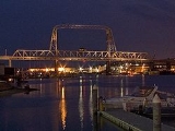
The Murray Morgan Bridge, also known as the 11th Street bridge or City Waterway bridge, is a lift bridge
in Tacoma, Washington
. It was built in 1913 to replace an 1894 swing-span bridge. The bridge connects downtown with the tideflats, it spans the Thea Foss Waterway
, originally known as the City Waterway. Designed by famous bridge designers Waddell
& Harrington, the bridge has some unusual features: higher above the water than most lift bridges, construction on a variable grade and an overhead span designed to carry a water pipe. The bridge structure also contained a wooden road which connected what is now Cliff Street with Dock Street. According to the Department of Transportation, the towers are 207' 1 3/4" (63.14 m) above the water, with the road deck 60' above the water level at zero tide. It was modified and updated in 1957 and was used to route State Route 509 through the tideflats. The bridge was bypassed in the late 1990s when State Route 509 was routed around the edge of the tideflats. While WSDOT wanted to tear down the bridge, the City of Tacoma convinced the state to transfer ownership to the City. The City of Tacoma currently has a plan to rehabilitate the bridge, however this process remains largely unfunded. In the past, the bridge has been heavily used by commuters and emergency services in connecting the Port of Tacoma with downtown Tacoma.
. Morgan was a bridge tender on the bridge during the 1950s. In fact, he wrote most of "Skid Road" during quiet periods on the job.
Map Coordinates: 47.253995°N 122.43327°W
Lift bridge
A vertical-lift bridge or lift bridge is a type of movable bridge in which a span rises vertically while remaining parallel with the deck....
in Tacoma, Washington
Tacoma, Washington
Tacoma is a mid-sized urban port city and the county seat of Pierce County, Washington, United States. The city is on Washington's Puget Sound, southwest of Seattle, northeast of the state capital, Olympia, and northwest of Mount Rainier National Park. The population was 198,397, according to...
. It was built in 1913 to replace an 1894 swing-span bridge. The bridge connects downtown with the tideflats, it spans the Thea Foss Waterway
Thea Foss Waterway
The Thea Foss Waterway is a waterway running roughly north-south immediately east of downtown Tacoma, Washington. It is an inlet of Commencement Bay.Tacoma was the site of an early sawmill in 1853.The deepwater port began to boom in the 1870s, sailing...
, originally known as the City Waterway. Designed by famous bridge designers Waddell
John Alexander Low Waddell
John Alexander Low Waddell was an American civil engineer and prolific bridge designer, with more than a thousand structures to his credit in the United States, Canada, as well as Mexico, Russia, China, Japan, and New Zealand...
& Harrington, the bridge has some unusual features: higher above the water than most lift bridges, construction on a variable grade and an overhead span designed to carry a water pipe. The bridge structure also contained a wooden road which connected what is now Cliff Street with Dock Street. According to the Department of Transportation, the towers are 207' 1 3/4" (63.14 m) above the water, with the road deck 60' above the water level at zero tide. It was modified and updated in 1957 and was used to route State Route 509 through the tideflats. The bridge was bypassed in the late 1990s when State Route 509 was routed around the edge of the tideflats. While WSDOT wanted to tear down the bridge, the City of Tacoma convinced the state to transfer ownership to the City. The City of Tacoma currently has a plan to rehabilitate the bridge, however this process remains largely unfunded. In the past, the bridge has been heavily used by commuters and emergency services in connecting the Port of Tacoma with downtown Tacoma.
Name
Originally known as the 11th Street Bridge, it was renamed May 21, 1997, to honor Tacoma-born Murray Morgan (1916–2000), the best-known Pacific Northwest historian of his generation, and author of "Skid Road", a history of Seattle, WashingtonSeattle, Washington
Seattle is the county seat of King County, Washington. With 608,660 residents as of the 2010 Census, Seattle is the largest city in the Northwestern United States. The Seattle metropolitan area of about 3.4 million inhabitants is the 15th largest metropolitan area in the country...
. Morgan was a bridge tender on the bridge during the 1950s. In fact, he wrote most of "Skid Road" during quiet periods on the job.
Closure
The bridge was officially closed on October 23, 2007 due to "life safety concerns". It remains to be seen if the bridge will ever reopen. The bridge was probably closed in the wake of the I-35W Mississippi River bridge collapse of 2007. The bridge remains open to pedestrian and bicycle traffic. Currently WSDOT plans to turn ownership back to the City of Tacoma as the bridge no longer serves a state-owned freeway, but rather city streets. The City of Tacoma is considering possibilities to rehabilitate the bridge with existing funding. The bridge was returned to limited pedestrian and bicycle service on March 31, 2010.Damage
On December 15, 2010 it was discovered that thieves broke into the mechanical room and took wiring from the control panel used to raise the bridge for ship traffic on the Foss Waterway. The city is looking for an interim method of operating the span with the estimated cost of replacing the equipment set at $250,000External links
- Historylink - Tacoma's Eleventh Street (City Waterway) Bridge opens on February 15, 1913.
- Historylink - Washington renames Tacoma's Eleventh Street Bridge as Murray Morgan Bridge on May 21, 1997.
- Puget Sound Transportation Projects - Murray Morgan Bridge
Map Coordinates: 47.253995°N 122.43327°W