
Gill, Massachusetts
Encyclopedia
Gill is a town
in Franklin County
, Massachusetts
, USA
. The population was 1,363 at the 2000 census. It is part of the Springfield, Massachusetts
Metropolitan Statistical Area
. The campus of Northfield Mount Hermon School is located in the Mount Hermon section of the town.
valley was occupied by the Nipmuc, and Algonquin-speaking
tribe. In the 1670s they had a village near the great falls of the of the Connecticut River that was called Peskeompscut. During King Philip's War
in 1676, Captain William Turner led 150 colonists in an attack
on this settlement, in which several hundred Indians (mostly women, children, and elderly) were slain.
Gill was first settled in 1776 and was officially incorporated in 1793. The town is named in honor of Moses Gill
, a member of Massachusetts' Executive Council who became lieutenant governor
in 1794 and acting governor
in 1799 when Governor Increase Sumner
died.
The first town meeting was held December 18, 1793, with Moses Bascom as moderator. Elected officers were Moses Bascom Jr. as town clerk and treasurer, Moses Bascom, William Smalley and Noah Munn as selectmen and assessors and David Squires as constable.
, the town has a total area of 14.8 square miles (38.3 km²), of which 14 square miles (36.3 km²) is land and 0.8 square miles (2.1 km²) (5.67%) is water.
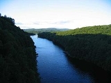
Gill is located on the west bank of the Connecticut River
, which flows along the town's eastern and southern edges.
The river forms most of the town's boundary with Northfield
, to the east, however, the FKB is entirely in Gill (SP Shelburne Falls has primary jurisdiction), and separates the town from Erving
, to the southeast, and Montague
, to the south. Fall River, a small tributary, forms the boundary with Greenfield
, to the southwest. Continuing clockwise, the town shares land boundaries with Bernardston
in the northwest, and a portion of Northfield to the north.
of 2000, there were 1,363 people, 537 households, and 373 families residing in the town. The population density
was 97.5 people per square mile (37.6/km²). There were 560 housing units at an average density of 40.1 per square mile (15.5/km²). The racial makeup of the town was 97.43% White, 0.29% African American, 0.07% Native American, 0.81% Asian, 0.37% from other races
, and 1.03% from two or more races. Hispanic or Latino of any race were 0.73% of the population.
There were 537 households out of which 32.6% had children under the age of 18 living with them, 58.1% were married couples
living together, 8.0% had a female householder with no husband present, and 30.5% were non-families. 23.1% of all households were made up of individuals and 10.8% had someone living alone who was 65 years of age or older. The average household size was 2.53 and the average family size was 3.03.
In the town the population was spread out with 23.7% under the age of 18, 6.6% from 18 to 24, 26.8% from 25 to 44, 30.2% from 45 to 64, and 12.8% who were 65 years of age or older. The median age was 42 years. For every 100 females there were 95.3 males. For every 100 females age 18 and over, there were 91.5 males.
The median income for a household in the town was $50,750, and the median income for a family was $61,339. Males had a median income of $35,402 versus $26,613 for females. The per capita income
for the town was $23,381. About 3.9% of families and 4.4% of the population were below the poverty line, including 2.5% of those under age 18 and 11.8% of those age 65 or over.
New England town
The New England town is the basic unit of local government in each of the six New England states. Without a direct counterpart in most other U.S. states, New England towns are conceptually similar to civil townships in other states, but are incorporated, possessing powers like cities in other...
in Franklin County
Franklin County, Massachusetts
-Demographics:As of the census of 2000, there were 71,535 people, 29,466 households, and 18,416 families residing in the county. The population density was 102 people per square mile . There were 31,939 housing units at an average density of 46 per square mile...
, Massachusetts
Massachusetts
The Commonwealth of Massachusetts is a state in the New England region of the northeastern United States of America. It is bordered by Rhode Island and Connecticut to the south, New York to the west, and Vermont and New Hampshire to the north; at its east lies the Atlantic Ocean. As of the 2010...
, USA
United States
The United States of America is a federal constitutional republic comprising fifty states and a federal district...
. The population was 1,363 at the 2000 census. It is part of the Springfield, Massachusetts
Springfield, Massachusetts
Springfield is the most populous city in Western New England, and the seat of Hampden County, Massachusetts, United States. Springfield sits on the eastern bank of the Connecticut River near its confluence with three rivers; the western Westfield River, the eastern Chicopee River, and the eastern...
Metropolitan Statistical Area
Springfield, Massachusetts metropolitan area
The Springfield Metropolitan Area is a region that is socio-economically and culturally tied to the City of Springfield, Massachusetts. The U.S. Office of Management and Budget defines the Springfield metropolitan statistical area as consisting of three counties in Western Massachusetts. As of...
. The campus of Northfield Mount Hermon School is located in the Mount Hermon section of the town.
History
Prior to the arrival of English colonists, the Massachusetts portion of the Connecticut RiverConnecticut River
The Connecticut River is the largest and longest river in New England, and also an American Heritage River. It flows roughly south, starting from the Fourth Connecticut Lake in New Hampshire. After flowing through the remaining Connecticut Lakes and Lake Francis, it defines the border between the...
valley was occupied by the Nipmuc, and Algonquin-speaking
Algonquin language
Algonquin is either a distinct Algonquian language closely related to the Ojibwe language or a particularly divergent Ojibwe dialect. It is spoken, alongside French and to some extent English, by the Algonquin First Nations of Quebec and Ontario...
tribe. In the 1670s they had a village near the great falls of the of the Connecticut River that was called Peskeompscut. During King Philip's War
King Philip's War
King Philip's War, sometimes called Metacom's War, Metacomet's War, or Metacom's Rebellion, was an armed conflict between Native American inhabitants of present-day southern New England and English colonists and their Native American allies in 1675–76. The war is named after the main leader of the...
in 1676, Captain William Turner led 150 colonists in an attack
Battle of Turner's Falls
The Battle of Turner's Falls, also known as the Peskeompscut massacre, was fought on May 19, 1676, during King Philip's War, in present-day Gill, Massachusetts, near a falls on the Connecticut River. The site is across the river from the village of Turners Falls...
on this settlement, in which several hundred Indians (mostly women, children, and elderly) were slain.
Gill was first settled in 1776 and was officially incorporated in 1793. The town is named in honor of Moses Gill
Moses Gill
Moses Gill was a Massachusetts politician who briefly served as Acting Governor of the state.-Life:He was a merchant living in Boston, until 1767, when he removed to Princeton, Massachusetts. In 1759 he married Sarah Prince, daughter to pastor Thomas Prince of Boston's Old South Church...
, a member of Massachusetts' Executive Council who became lieutenant governor
Lieutenant governor (United States)
In the United States, 43 of the 50 states have a separate, full-time office of lieutenant governor. In most cases, the lieutenant governor is the highest officer of state after the governor, standing in for that officer when he or she is absent from the state or temporarily incapacitated...
in 1794 and acting governor
Acting governor
An acting governor is a constitutional position created in some U.S. states when the governor dies in office or resigns. In some states, the governor may also be declared to be incapacitated and unable to function for various reasons, including illness and absence from the state for more than a...
in 1799 when Governor Increase Sumner
Increase Sumner
Increase Sumner was an American politician from Massachusetts. He served as the fifth governor of Massachusetts from 1797 to 1799. Trained as a lawyer, he served in the provisional government of Massachusetts during the American Revolutionary War, and was elected to the Confederation Congress in...
died.
The first town meeting was held December 18, 1793, with Moses Bascom as moderator. Elected officers were Moses Bascom Jr. as town clerk and treasurer, Moses Bascom, William Smalley and Noah Munn as selectmen and assessors and David Squires as constable.
Geography
According to the United States Census BureauUnited States Census Bureau
The United States Census Bureau is the government agency that is responsible for the United States Census. It also gathers other national demographic and economic data...
, the town has a total area of 14.8 square miles (38.3 km²), of which 14 square miles (36.3 km²) is land and 0.8 square miles (2.1 km²) (5.67%) is water.
Gill is located on the west bank of the Connecticut River
Connecticut River
The Connecticut River is the largest and longest river in New England, and also an American Heritage River. It flows roughly south, starting from the Fourth Connecticut Lake in New Hampshire. After flowing through the remaining Connecticut Lakes and Lake Francis, it defines the border between the...
, which flows along the town's eastern and southern edges.
The river forms most of the town's boundary with Northfield
Northfield, Massachusetts
Northfield is a town in Franklin County, Massachusetts, United States. The population was 2,951 at the 2000 census. It is part of the Springfield, Massachusetts Metropolitan Statistical Area...
, to the east, however, the FKB is entirely in Gill (SP Shelburne Falls has primary jurisdiction), and separates the town from Erving
Erving, Massachusetts
Erving is a town in Franklin County, Massachusetts, United States. The population was 1,467 at the 2000 census. It is part of the Springfield, Massachusetts metropolitan statistical area.-History:...
, to the southeast, and Montague
Montague, Massachusetts
Montague is a town in Franklin County, Massachusetts, United States. The population was 8,489 at the 2000 census. It is part of the Springfield, Massachusetts metropolitan statistical area....
, to the south. Fall River, a small tributary, forms the boundary with Greenfield
Greenfield, Massachusetts
Greenfield is a city in Franklin County, Massachusetts, United States. The population was 17,456 at the 2010 census. It is the county seat of Franklin County. Greenfield is home to Greenfield Community College, the Pioneer Valley Symphony Orchestra, and the Franklin County Fair...
, to the southwest. Continuing clockwise, the town shares land boundaries with Bernardston
Bernardston, Massachusetts
Bernardston is a town in Franklin County, Massachusetts, United States. The population was 2,155 at the 2000 census. It is part of the Springfield, Massachusetts Metropolitan Statistical Area.- History :...
in the northwest, and a portion of Northfield to the north.
Demographics
As of the censusCensus
A census is the procedure of systematically acquiring and recording information about the members of a given population. It is a regularly occurring and official count of a particular population. The term is used mostly in connection with national population and housing censuses; other common...
of 2000, there were 1,363 people, 537 households, and 373 families residing in the town. The population density
Population density
Population density is a measurement of population per unit area or unit volume. It is frequently applied to living organisms, and particularly to humans...
was 97.5 people per square mile (37.6/km²). There were 560 housing units at an average density of 40.1 per square mile (15.5/km²). The racial makeup of the town was 97.43% White, 0.29% African American, 0.07% Native American, 0.81% Asian, 0.37% from other races
Race (United States Census)
Race and ethnicity in the United States Census, as defined by the Federal Office of Management and Budget and the United States Census Bureau, are self-identification data items in which residents choose the race or races with which they most closely identify, and indicate whether or not they are...
, and 1.03% from two or more races. Hispanic or Latino of any race were 0.73% of the population.
There were 537 households out of which 32.6% had children under the age of 18 living with them, 58.1% were married couples
Marriage
Marriage is a social union or legal contract between people that creates kinship. It is an institution in which interpersonal relationships, usually intimate and sexual, are acknowledged in a variety of ways, depending on the culture or subculture in which it is found...
living together, 8.0% had a female householder with no husband present, and 30.5% were non-families. 23.1% of all households were made up of individuals and 10.8% had someone living alone who was 65 years of age or older. The average household size was 2.53 and the average family size was 3.03.
In the town the population was spread out with 23.7% under the age of 18, 6.6% from 18 to 24, 26.8% from 25 to 44, 30.2% from 45 to 64, and 12.8% who were 65 years of age or older. The median age was 42 years. For every 100 females there were 95.3 males. For every 100 females age 18 and over, there were 91.5 males.
The median income for a household in the town was $50,750, and the median income for a family was $61,339. Males had a median income of $35,402 versus $26,613 for females. The per capita income
Per capita income
Per capita income or income per person is a measure of mean income within an economic aggregate, such as a country or city. It is calculated by taking a measure of all sources of income in the aggregate and dividing it by the total population...
for the town was $23,381. About 3.9% of families and 4.4% of the population were below the poverty line, including 2.5% of those under age 18 and 11.8% of those age 65 or over.
Points of interest
- Bascom Hollow Farm, historic 18th Century farmstead established by Moses Bascom, Agricultural Preserve
- Northfield Mount Hermon School
- The Gill Tavern
- Upinngil, farm store
- French King BridgeFrench King BridgeThe French King Bridge is a three-span "cantilever arch" style bridge crossing the Connecticut River on the border of the towns of Erving and Gill, Massachusetts...
- Gill–Montague Bridge
- Renaissance CommunityRenaissance CommunityThe Brotherhood of the Spirit was one of the largest and most enduring communes in the northeast United States and as such was a distinct link between the commune phenomenon of the 1960s and the current New Age movement...
- Turners Falls Dam