
.gif)
Washington Avenue Bridge (Minneapolis)
Encyclopedia
The Washington Avenue Bridge carries County Road 122
across the Mississippi River
in Minneapolis, Minnesota
and connects the East Bank and West Bank portions of the University of Minnesota
's main campus. The bridge has two decks, with the lower deck designated for motor vehicle traffic and the upper deck used for pedestrians and bicycles (lanes specifically for bikes are on the north side). It is a utilitarian structure with simple architecture
, but it has cultural significance because thousands of students, faculty, staff, and visitors walk across it every day.
Most users of the bridge get across it using some mode other than a personal automobile. Mn/DOT
traffic counts from 2007 show the bridge carried about 28,400 vehicles per day at that time. However, multiple counts from 2009 indicate the bridge carried a total of 71,400 people per day when other modes were also included. The greatest single mode was still motor vehicles at 37.6%, but 32.7% used bus transit, 19.9% walked, and 9.6% used bicycles, with a remaining 0.3% using other methods such as inline skating
. The bridge is a cycling hot spot and, with 6,850 riders per day, may carry more bikes than any other route in Minneapolis.
In 2011, as part of construction for the Green Line
light rail
line, reconfiguration of the bridge began. When completed, the original two eastbound and two westbound auto traffic lanes will be permanently reduced to one lane eastbound and one lane westbound, using the outside lanes. The two inside (center) lanes will be dedicated to light rail. Construction on the bridge is expected to be complete around November 2012, but the light rail line is not expected to open until 2014.
truss
bridge was first built here in 1884, slightly upstream from the current location (connecting Washington Avenue
on both sides of the river). At the time of construction, many people lived in the river flats area below, a neighborhood known as Bohemian Flats
(See photo below). The bridge was strengthened in 1890 to accommodate streetcars, and it made up part of the first interurban line between Minneapolis and neighboring Saint Paul
(see Twin City Rapid Transit
). Streetcar service ended in 1954. Construction of the current bridge began in 1962. The 1884 bridge was torn down in 1965.
The top deck on the new bridge was originally just a flat space. Traversing the bridge in the harshness of winter was very uncomfortable, so an enclosure running down the center of the pedestrian area was added by the 1970s. Originally meant to be a heated indoor pedestrian area, due to energy cost concerns, the walkway is mostly unheated. There are some heaters inside that keep the area slightly warmer than outside, and some heat loss from the steam mains, but it can still dip below the freezing point. The structure also adds a windbreak
for the top level, improving conditions for people who choose to walk outside. In the summer, large overhangs also provide some shade.
 At least one designer had much grander plans. Winston Close, an adviser from the university to the architectural team, envisioned modeling the top level on the Ponte Vecchio
bridge in Florence, Italy. This would have included shops, making the bridge a place to stay rather than just get across. Some effort has been put into making the site a more inviting place. The addition of the upper deck enclosure led to an annual artistic event held on the first few days of classes, where organizations of all stripes can put their brushes to panels lining the interior. While most are self-promotional messages from campus groups, some of the panels always show impressive designs.
The exterior of the bridge had been a rather drab combination of brown and gray for most of its existence. Some felt that it was off-balance in its university surroundings, especially after the Frank Gehry
-designed Weisman Art Museum
went into place next to the east end in the 1990s. University President Mark Yudof
led a "Take Pride in U" campaign in 1997 where the top level was painted in the school colors
of maroon and gold. Later, in the first decade of the 2000s, the superstructure
was also painted over the course of about two years. This had to be arranged with Hennepin County, which owns the bridge. It took such a long time because the old paint contained lead
and had to be carefully removed.
 A darker facet of the bridge's history is its association with suicide. Poet and university professor John Berryman
is the most famous person to have killed himself at the site, when he jumped from the bridge in 1972. About a half-dozen others have also died by landing in the river or on the flats area.
The bridge was reduced to one lane in each direction in early 2011 as construction for the Green Line light rail line got underway in the area, and upper deck traffic has been shifted to one half of the bridge. As of March 2011, construction is occurring on the south side of the bridge, while traffic is flowing on the north side. The two sides will eventually flip so the other half of the bridge can be upgraded.
On 16 May 2011, Washington Avenue just east of the bridge was permanently closed to personal motor vehicle traffic. The roadway is to be converted for exclusive use as a transit mall
between Pleasant and Walnut Streets, so all eastbound lower-level traffic other than buses and emergency vehicles must exit to East River Parkway/Delaware Street, and the only westbound access to the bridge for most cars will be from Pleasant Street Southeast.
in the 1980s. The roadway appears to have been briefly designated as Minnesota State Highway 12. The road corridor between Interstate 35W
in the west and University Avenue
in the east was soon designated as Minnesota State Highway 122, but that ended in 1997 when Hennepin County
took over control of the roadway from the Minnesota Department of Transportation
. Today, Washington Avenue is disjointed, so returning to Washington Avenue after crossing the bridge westbound requires taking the first exit upon reaching the west side, or turning north after reaching downtown.
County Road 122 (Hennepin County, Minnesota)
Hennepin County Road 122 is an unsigned county state-aid highway within the city of Minneapolis, Hennepin County, Minnesota, United States, crossing the Mississippi River on the Washington Avenue Bridge.-Route description:...
across the Mississippi River
Mississippi River
The Mississippi River is the largest river system in North America. Flowing entirely in the United States, this river rises in western Minnesota and meanders slowly southwards for to the Mississippi River Delta at the Gulf of Mexico. With its many tributaries, the Mississippi's watershed drains...
in Minneapolis, Minnesota
Minneapolis, Minnesota
Minneapolis , nicknamed "City of Lakes" and the "Mill City," is the county seat of Hennepin County, the largest city in the U.S. state of Minnesota, and the 48th largest in the United States...
and connects the East Bank and West Bank portions of the University of Minnesota
University of Minnesota
The University of Minnesota, Twin Cities is a public research university located in Minneapolis and St. Paul, Minnesota, United States. It is the oldest and largest part of the University of Minnesota system and has the fourth-largest main campus student body in the United States, with 52,557...
's main campus. The bridge has two decks, with the lower deck designated for motor vehicle traffic and the upper deck used for pedestrians and bicycles (lanes specifically for bikes are on the north side). It is a utilitarian structure with simple architecture
Architecture
Architecture is both the process and product of planning, designing and construction. Architectural works, in the material form of buildings, are often perceived as cultural and political symbols and as works of art...
, but it has cultural significance because thousands of students, faculty, staff, and visitors walk across it every day.
Most users of the bridge get across it using some mode other than a personal automobile. Mn/DOT
Minnesota Department of Transportation
The Minnesota Department of Transportation oversees transportation by land, water, and air in the U.S. state of Minnesota. The cabinet-level agency is responsible for maintaining the state's trunk highway system The Minnesota Department of Transportation (Mn/DOT, pronounced "min-dot") oversees...
traffic counts from 2007 show the bridge carried about 28,400 vehicles per day at that time. However, multiple counts from 2009 indicate the bridge carried a total of 71,400 people per day when other modes were also included. The greatest single mode was still motor vehicles at 37.6%, but 32.7% used bus transit, 19.9% walked, and 9.6% used bicycles, with a remaining 0.3% using other methods such as inline skating
Inline skating
Inline skating is a recreational sport practiced widely internationally. Inline skates typically have 2 to 5 polyurethane wheels, arranged in a single line. The in-line design allows for greater speed than roller skates and better maneuverability...
. The bridge is a cycling hot spot and, with 6,850 riders per day, may carry more bikes than any other route in Minneapolis.
In 2011, as part of construction for the Green Line
Central Corridor (Minnesota)
The Central Corridor is a light rail line under construction that is to cover the stretch between the downtown regions of Minneapolis and Saint Paul in Minnesota...
light rail
Light rail
Light rail or light rail transit is a form of urban rail public transportation that generally has a lower capacity and lower speed than heavy rail and metro systems, but higher capacity and higher speed than traditional street-running tram systems...
line, reconfiguration of the bridge began. When completed, the original two eastbound and two westbound auto traffic lanes will be permanently reduced to one lane eastbound and one lane westbound, using the outside lanes. The two inside (center) lanes will be dedicated to light rail. Construction on the bridge is expected to be complete around November 2012, but the light rail line is not expected to open until 2014.
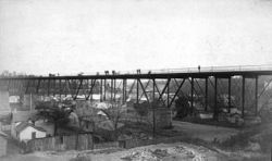
The first bridge (1884–1965)
An ironIron
Iron is a chemical element with the symbol Fe and atomic number 26. It is a metal in the first transition series. It is the most common element forming the planet Earth as a whole, forming much of Earth's outer and inner core. It is the fourth most common element in the Earth's crust...
truss
Truss
In architecture and structural engineering, a truss is a structure comprising one or more triangular units constructed with straight members whose ends are connected at joints referred to as nodes. External forces and reactions to those forces are considered to act only at the nodes and result in...
bridge was first built here in 1884, slightly upstream from the current location (connecting Washington Avenue
Washington Avenue (Minneapolis)
Washington Avenue is a major thoroughfare in Minneapolis, Minnesota. Starting north of Lowry Avenue, the street runs straight south, with Interstate 94 running alongside it until just south of West Broadway, when the freeway turns to the west...
on both sides of the river). At the time of construction, many people lived in the river flats area below, a neighborhood known as Bohemian Flats
Bohemian Flats
Bohemian Flats, also known as Little Bohemia, is the informal name given a residential area of what is now Minneapolis, Minnesota. The area was the low lying river terrace on west bank of the Mississippi River, a short distance southeast of St. Anthony Falls. About the time Minneapolis was...
(See photo below). The bridge was strengthened in 1890 to accommodate streetcars, and it made up part of the first interurban line between Minneapolis and neighboring Saint Paul
Saint Paul, Minnesota
Saint Paul is the capital and second-most populous city of the U.S. state of Minnesota. The city lies mostly on the east bank of the Mississippi River in the area surrounding its point of confluence with the Minnesota River, and adjoins Minneapolis, the state's largest city...
(see Twin City Rapid Transit
Twin City Rapid Transit
The Twin City Rapid Transit Company , also known as Twin City Lines , was a transportation company that operated streetcars, and buses in the Minneapolis-St. Paul metropolitan area in the U.S. state of Minnesota...
). Streetcar service ended in 1954. Construction of the current bridge began in 1962. The 1884 bridge was torn down in 1965.
The second bridge (1965–present)
This first structure was a straight east-west bridge carrying Washington Avenue, which continued directly into downtown. The new bridge aimed the west end slightly to the south, so Washington Avenue is now disjointed at that point. Continuing straight along the roadway will carry a vehicle into downtown along a short freeway-like section that meets 3rd Street South (a one-way—returning involves traveling along 4th Street).The top deck on the new bridge was originally just a flat space. Traversing the bridge in the harshness of winter was very uncomfortable, so an enclosure running down the center of the pedestrian area was added by the 1970s. Originally meant to be a heated indoor pedestrian area, due to energy cost concerns, the walkway is mostly unheated. There are some heaters inside that keep the area slightly warmer than outside, and some heat loss from the steam mains, but it can still dip below the freezing point. The structure also adds a windbreak
Windbreak
A windbreak or shelterbelt is a plantation usually made up of one or more rows of trees or shrubs planted in such a manner as to provide shelter from the wind and to protect soil from erosion. They are commonly planted around the edges of fields on farms. If designed properly, windbreaks around a...
for the top level, improving conditions for people who choose to walk outside. In the summer, large overhangs also provide some shade.
Ponte Vecchio
The Ponte Vecchio is a Medieval stone closed-spandrel segmental arch bridge over the Arno River, in Florence, Italy, noted for still having shops built along it, as was once common. Butchers initially occupied the shops; the present tenants are jewellers, art dealers and souvenir sellers...
bridge in Florence, Italy. This would have included shops, making the bridge a place to stay rather than just get across. Some effort has been put into making the site a more inviting place. The addition of the upper deck enclosure led to an annual artistic event held on the first few days of classes, where organizations of all stripes can put their brushes to panels lining the interior. While most are self-promotional messages from campus groups, some of the panels always show impressive designs.
The exterior of the bridge had been a rather drab combination of brown and gray for most of its existence. Some felt that it was off-balance in its university surroundings, especially after the Frank Gehry
Frank Gehry
Frank Owen Gehry, is a Canadian American Pritzker Prize-winning architect based in Los Angeles, California.His buildings, including his private residence, have become tourist attractions...
-designed Weisman Art Museum
Weisman Art Museum
The Frederick R. Weisman Art Museum is an art museum located on the University of Minnesota campus in Minneapolis. A teaching museum for the university since 1934, the museum is named for Frederick R. Weisman, and was designed by the renowned architect Frank Gehry...
went into place next to the east end in the 1990s. University President Mark Yudof
Mark Yudof
Mark G. Yudof is an American law professor and academic administrator. He is president of the University of California , former chancellor of the University of Texas System , and former president of the University of Minnesota .In addition to his position as Chancellor at The University of Texas,...
led a "Take Pride in U" campaign in 1997 where the top level was painted in the school colors
School colors
School colors are the colors chosen by a school to represent it on uniforms and other items of identification. Most schools have two colors, which are usually chosen to avoid conflicts with other schools with which the school competes in sports and other activities...
of maroon and gold. Later, in the first decade of the 2000s, the superstructure
Superstructure
A superstructure is an upward extension of an existing structure above a baseline. This term is applied to various kinds of physical structures such as buildings, bridges, or ships...
was also painted over the course of about two years. This had to be arranged with Hennepin County, which owns the bridge. It took such a long time because the old paint contained lead
Lead paint
Lead paint or lead-based paint is paint containing lead, a heavy metal, that is used as pigment, with lead chromate and lead carbonate being the most common. Lead is also added to paint to speed drying, increase durability, retain a fresh appearance, and resist moisture that causes corrosion...
and had to be carefully removed.
John Berryman
John Allyn Berryman was an American poet and scholar, born in McAlester, Oklahoma. He was a major figure in American poetry in the second half of the 20th century and was considered a key figure in the Confessional school of poetry...
is the most famous person to have killed himself at the site, when he jumped from the bridge in 1972. About a half-dozen others have also died by landing in the river or on the flats area.
2008 repairs and pedestrian-level restrictions
In August 2008, concerns about the strength of the upper level led Hennepin County to restrict the pedestrian and bicycle traffic to a 14-foot-wide section in the center. Engineers had decided that in preparation for repairs, the weight needed to be moved to the center, where there was support from the columns below. Usage of the upper deck continued to be restricted for about a year until repairs were complete.2011–2012 upgrades for light rail
The 1965 bridge was designed as a fracture-critical structure, meaning that it lacks redundancy in its design and could collapse if any single one of certain load-bearing members were to fail. Upgrades will strengthen the bridge to help it carry the 106000 pounds (48,080.8 kg) rail vehicles, and will add redundancy so that the failure of a single bridge member would not cause a catastrophe.The bridge was reduced to one lane in each direction in early 2011 as construction for the Green Line light rail line got underway in the area, and upper deck traffic has been shifted to one half of the bridge. As of March 2011, construction is occurring on the south side of the bridge, while traffic is flowing on the north side. The two sides will eventually flip so the other half of the bridge can be upgraded.
On 16 May 2011, Washington Avenue just east of the bridge was permanently closed to personal motor vehicle traffic. The roadway is to be converted for exclusive use as a transit mall
Transit mall
A transit mall is a street, or set of streets, in a city or town along which automobile traffic is prohibited or greatly restricted and only public transit vehicles, bicycles and pedestrians are permitted....
between Pleasant and Walnut Streets, so all eastbound lower-level traffic other than buses and emergency vehicles must exit to East River Parkway/Delaware Street, and the only westbound access to the bridge for most cars will be from Pleasant Street Southeast.
Roadway designations
Historically, the Washington Avenue Bridge carried U.S. Highway 12 and U.S. Highway 52, but those highways were officially rerouted along nearby Interstate 94Interstate 94
Interstate 94 is the northernmost east–west Interstate Highway, connecting the Great Lakes and Intermountain regions of the United States. I-94's western terminus is in Billings, Montana at a junction with Interstate 90; its eastern terminus is the U.S...
in the 1980s. The roadway appears to have been briefly designated as Minnesota State Highway 12. The road corridor between Interstate 35W
Interstate 35W (Minnesota)
Interstate 35W , is an Interstate Highway in the U.S. state of Minnesota, passing through downtown Minneapolis. It is one of two through routes for Interstate 35 through the Twin Cities of Minneapolis and Saint Paul, the other being Interstate 35E through downtown Saint Paul...
in the west and University Avenue
University Avenue (Minneapolis-St. Paul)
University Avenue in the Minneapolis–St. Paul region of Minnesota begins near the Minnesota State Capitol in Saint Paul and extends westward into neighboring Minneapolis, where it passes the University of Minnesota, and then turns north to pass through several suburbs before ending in Blaine,...
in the east was soon designated as Minnesota State Highway 122, but that ended in 1997 when Hennepin County
Hennepin County, Minnesota
Hennepin County is a county located in the U.S. state of Minnesota, named in honor of the 17th-century explorer Father Louis Hennepin. As of 2010 the population was 1,152,425. Its county seat is Minneapolis. It is by far the most populous county in Minnesota; more than one in five Minnesotans live...
took over control of the roadway from the Minnesota Department of Transportation
Minnesota Department of Transportation
The Minnesota Department of Transportation oversees transportation by land, water, and air in the U.S. state of Minnesota. The cabinet-level agency is responsible for maintaining the state's trunk highway system The Minnesota Department of Transportation (Mn/DOT, pronounced "min-dot") oversees...
. Today, Washington Avenue is disjointed, so returning to Washington Avenue after crossing the bridge westbound requires taking the first exit upon reaching the west side, or turning north after reaching downtown.