
Gulf Breeze, Florida
Encyclopedia
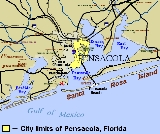
Gulf Breeze is a city located on the Fairpoint Peninsula
in Santa Rosa County, Florida
, United States
and is a suburb
of Pensacola
which lies to the north, across Pensacola Bay
. The population was 5,665 at the 2000 census. As of 2005, the population estimated by the U.S. Census Bureau is 6,455. However, as of the 2010 U.S. Census Gulf Breeze showed a population reduction to 5,763.http://factfinder.census.gov/servlet/SAFFPopulation?_event=Search&_name=Gulf+Breeze&_state=04000US12&_county=Gulf+Breeze&_cityTown=Gulf+Breeze&_zip=&_sse=on&_lang=en&pctxt=fph
According to the United States Census Bureau
, the city has a total area of 23.5 square miles (60.9 km²).4.8 square miles (12.3 km²) of it is land and 18.8 square miles (48.7 km²) of it (79.79%) is water.
Growth of the city itself is geographically restricted, surrounded by major water bodies on three sides. Additionally, the eastern portion of Gulf Breeze is occupied by the Naval Live Oaks Reservation. As a result, new growth occurs east of the city limits along U.S. Highway 98
.
and Opal made landfall just south of the city. While Erin caused mild damage to the area, Hurricane Opal
devastated much of the neighboring Pensacola Beach and Navarre communities. Nine years later, in 2004, Hurricane Ivan
made landfall west of the Gulf Breeze but caused widespread damage in the city, destroying many homes and businesses. In 2005, Hurricane Dennis
passed just east of the city. Damage from this storm was more severe than that received in communities lying further west.
).
The Gulf Breeze Zoo ia a 50 acre zoo that includes hundreds of animals, a boardwalk overlooking a free range preserve, CP Huntington style train, as well as other amenities. The Gulf Breeze Zoo features various events throughout the year including Boo at the Zoo and Zoo Lights.
Gulf Breeze also received media
attention for instituting a program to allow volunteers to drive police car
s within the city and report traffic violations
to police
. Volunteers receive training in radio use and first aid but are not empowered to make arrest
s or traffic stops.
of 2000, there were 5,665 people, 2,377 households, and 1,678 families residing in the city. The population density
was 1,192.0 people per square mile (460.5/km²). There were 2,553 housing units at an average density of 537.2 per square mile (207.5/km²). The racial makeup of the city was 97.39% White, 0.25% African American, 0.55% Native American, 0.56% Asian, 0.02% Pacific Islander, 0.18% from other races
, and 1.06% from two or more races. Hispanic or Latino of any race were 1.36% of the population.
There were 2,377 households out of which 28.1% had children under the age of 18 living with them, 57.7% were married couples
living together, 10.6% had a female householder with no husband present, and 29.4% were non-families. 25.3% of all households were made up of individuals and 13.0% had someone living alone who was 65 years of age or older. The average household size was 2.36 and the average family size was 2.83.
In the city the population was spread out with 22.3% under the age of 18, 4.6% from 18 to 24, 22.5% from 25 to 44, 29.7% from 45 to 64, and 20.8% who were 65 years of age or older. The median age was 45 years. For every 100 females there were 89.4 males. For every 100 females age 18 and over, there were 83.6 males.
The median income for a household in the city was $52,522, and the median income for a family was $61,661. Males had a median income of $44,408 versus $28,159 for females. The per capita income
for the city was $34,688. About 3.8% of families and 4.2% of the population were below the poverty line, including 5.5% of those under age 18 and 1.2% of those age 65 or over.
Fairpoint Peninsula
The Fairpoint Peninsula is a peninsula located in the Florida Panhandle . It separates Santa Rosa Sound to the south from Pensacola Bay to the north. The Gulf Intracoastal Waterway is routed south of the peninsula through Santa Rosa Sound...
in Santa Rosa County, Florida
Santa Rosa County, Florida
Santa Rosa County is a county located in the U.S. state of Florida. According to the 2000 U.S. Census, the population was 117,743, while a July 1, 2005, estimate placed the population at 143,105, an 18% increase making it the 84th fastest growing county in the United States between 2000 and 2005. ...
, United States
United States
The United States of America is a federal constitutional republic comprising fifty states and a federal district...
and is a suburb
Suburb
The word suburb mostly refers to a residential area, either existing as part of a city or as a separate residential community within commuting distance of a city . Some suburbs have a degree of administrative autonomy, and most have lower population density than inner city neighborhoods...
of Pensacola
Pensacola, Florida
Pensacola is the westernmost city in the Florida Panhandle and the county seat of Escambia County, Florida, United States of America. As of the 2000 census, the city had a total population of 56,255 and as of 2009, the estimated population was 53,752...
which lies to the north, across Pensacola Bay
Pensacola Bay
Pensacola Bay is a bay located in the northwestern part of Florida, United States, known as the Florida Panhandle.The bay, an inlet of the Gulf of Mexico, is located in Escambia County and Santa Rosa County, adjacent to the city of Pensacola, Florida, and is about 13 miles long and 2.5 miles ...
. The population was 5,665 at the 2000 census. As of 2005, the population estimated by the U.S. Census Bureau is 6,455. However, as of the 2010 U.S. Census Gulf Breeze showed a population reduction to 5,763.http://factfinder.census.gov/servlet/SAFFPopulation?_event=Search&_name=Gulf+Breeze&_state=04000US12&_county=Gulf+Breeze&_cityTown=Gulf+Breeze&_zip=&_sse=on&_lang=en&pctxt=fph
Geography and Climate
Gulf Breeze is located at 30°21′36"N 87°10′41"W (30.359933, -87.178190).According to the United States Census Bureau
United States Census Bureau
The United States Census Bureau is the government agency that is responsible for the United States Census. It also gathers other national demographic and economic data...
, the city has a total area of 23.5 square miles (60.9 km²).4.8 square miles (12.3 km²) of it is land and 18.8 square miles (48.7 km²) of it (79.79%) is water.
Growth of the city itself is geographically restricted, surrounded by major water bodies on three sides. Additionally, the eastern portion of Gulf Breeze is occupied by the Naval Live Oaks Reservation. As a result, new growth occurs east of the city limits along U.S. Highway 98
U.S. Route 98
U.S. Route 98 is an east–west United States highway that runs from western Mississippi to southern Florida. It was established in 1933 as a route between Pensacola, Florida and Apalachicola, Florida, and has since been extended westward into Mississippi and eastward across the Florida...
.
Hurricanes
From 1995 to 2005, Gulf Breeze has received several direct hits and severe blows from numerous hurricanes. In 1995, Hurricane ErinHurricane Erin (1995)
Hurricane Erin was the fifth named tropical cyclone and the second hurricane of the unusually active 1995 Atlantic hurricane season. Erin began as a tropical wave off the west coast of Africa on July 22, and crossed the Atlantic ocean without ever developing. On July 31, the last day of the month,...
and Opal made landfall just south of the city. While Erin caused mild damage to the area, Hurricane Opal
Hurricane Opal
Hurricane Opal was a Category 4 hurricane that formed in the Gulf of Mexico in September 1995.Opal was the ninth hurricane and the strongest of the abnormally active 1995 Atlantic hurricane season...
devastated much of the neighboring Pensacola Beach and Navarre communities. Nine years later, in 2004, Hurricane Ivan
Hurricane Ivan
Hurricane Ivan was a large, long-lived, Cape Verde-type hurricane that caused widespread damage in the Caribbean and United States. The cyclone was the ninth named storm, the sixth hurricane and the fourth major hurricane of the active 2004 Atlantic hurricane season...
made landfall west of the Gulf Breeze but caused widespread damage in the city, destroying many homes and businesses. In 2005, Hurricane Dennis
Hurricane Dennis
Hurricane Dennis was an early-forming major hurricane in the Caribbean and Gulf of Mexico during the very active 2005 Atlantic hurricane season. Dennis was the fourth named storm, second hurricane, and first major hurricane of the season...
passed just east of the city. Damage from this storm was more severe than that received in communities lying further west.
Points of interest
Gulf Breeze became famous in 1987 as the site of several UFO sightings. (see Gulf Breeze UFO incidentGulf Breeze UFO incident
The Gulf Breeze UFO incident is a famous series of UFO sightings which occurred beginning on November 11, 1987.Gulf Breeze was a small city in Florida of approximately 6,000 at the time of a wave of UFO sightings that began in late 1987...
).
The Gulf Breeze Zoo ia a 50 acre zoo that includes hundreds of animals, a boardwalk overlooking a free range preserve, CP Huntington style train, as well as other amenities. The Gulf Breeze Zoo features various events throughout the year including Boo at the Zoo and Zoo Lights.
Gulf Breeze also received media
Mass media
Mass media refers collectively to all media technologies which are intended to reach a large audience via mass communication. Broadcast media transmit their information electronically and comprise of television, film and radio, movies, CDs, DVDs and some other gadgets like cameras or video consoles...
attention for instituting a program to allow volunteers to drive police car
Police car
A police car is a ground vehicle used by police, to assist with their duties in patrolling and responding to incidents. Typical uses of a police car include transportation for officers to reach the scene of an incident quickly, to transport criminal suspects, or to patrol an area, while providing a...
s within the city and report traffic violations
Moving violation
A moving violation is any violation of the law committed by the driver of a vehicle while it is in motion. The term "motion" distinguishes it from other violations such as parking violations, equipment violations, or paperwork violations relating to insurance, registration, inspection, etc.-...
to police
Police
The police is a personification of the state designated to put in practice the enforced law, protect property and reduce civil disorder in civilian matters. Their powers include the legitimized use of force...
. Volunteers receive training in radio use and first aid but are not empowered to make arrest
Arrest
An arrest is the act of depriving a person of his or her liberty usually in relation to the purported investigation and prevention of crime and presenting into the criminal justice system or harm to oneself or others...
s or traffic stops.
Demographics
As of the censusCensus
A census is the procedure of systematically acquiring and recording information about the members of a given population. It is a regularly occurring and official count of a particular population. The term is used mostly in connection with national population and housing censuses; other common...
of 2000, there were 5,665 people, 2,377 households, and 1,678 families residing in the city. The population density
Population density
Population density is a measurement of population per unit area or unit volume. It is frequently applied to living organisms, and particularly to humans...
was 1,192.0 people per square mile (460.5/km²). There were 2,553 housing units at an average density of 537.2 per square mile (207.5/km²). The racial makeup of the city was 97.39% White, 0.25% African American, 0.55% Native American, 0.56% Asian, 0.02% Pacific Islander, 0.18% from other races
Race (United States Census)
Race and ethnicity in the United States Census, as defined by the Federal Office of Management and Budget and the United States Census Bureau, are self-identification data items in which residents choose the race or races with which they most closely identify, and indicate whether or not they are...
, and 1.06% from two or more races. Hispanic or Latino of any race were 1.36% of the population.
There were 2,377 households out of which 28.1% had children under the age of 18 living with them, 57.7% were married couples
Marriage
Marriage is a social union or legal contract between people that creates kinship. It is an institution in which interpersonal relationships, usually intimate and sexual, are acknowledged in a variety of ways, depending on the culture or subculture in which it is found...
living together, 10.6% had a female householder with no husband present, and 29.4% were non-families. 25.3% of all households were made up of individuals and 13.0% had someone living alone who was 65 years of age or older. The average household size was 2.36 and the average family size was 2.83.
In the city the population was spread out with 22.3% under the age of 18, 4.6% from 18 to 24, 22.5% from 25 to 44, 29.7% from 45 to 64, and 20.8% who were 65 years of age or older. The median age was 45 years. For every 100 females there were 89.4 males. For every 100 females age 18 and over, there were 83.6 males.
The median income for a household in the city was $52,522, and the median income for a family was $61,661. Males had a median income of $44,408 versus $28,159 for females. The per capita income
Per capita income
Per capita income or income per person is a measure of mean income within an economic aggregate, such as a country or city. It is calculated by taking a measure of all sources of income in the aggregate and dividing it by the total population...
for the city was $34,688. About 3.8% of families and 4.2% of the population were below the poverty line, including 5.5% of those under age 18 and 1.2% of those age 65 or over.
Schools
- Gulf Breeze High SchoolGulf Breeze High SchoolGulf Breeze High School is a public secondary school located at 675 Gulf Breeze Parkway in Gulf Breeze, Florida. It is one of six high schools of the Santa Rosa County School District and is the only high school in the city of Gulf Breeze....
(website) - Gulf Breeze Middle School
- Gulf Breeze Elementary School
- Oriole Beach Elementary School
External links
- The Gulf Breeze Zoo — the regional zoo.
- Gulf Breeze Area Chamber of Commerce — the area's chamber of commerceChamber of commerceA chamber of commerce is a form of business network, e.g., a local organization of businesses whose goal is to further the interests of businesses. Business owners in towns and cities form these local societies to advocate on behalf of the business community...