

Crown Point, New York
Encyclopedia
Crown Point is a town
in Essex County
, New York
, USA
. The population was 2,119 at the 2000 census. The name of the town is a direct translation of the original French name, "Point au Chevalure."
The Town of Crown Point is on the eastern edge of the county. It is 39 miles (62.8 km) southwest of Burlington, VT, 44 miles (70.8 km) north-northeast from Queensbury, NY, 108 miles (173.8 km) south of Montreal, Quebec, and 90 miles (144.8 km) north of Albany, New York
.
by the French
and later Fort Crown Point
by the British
.
During colonial times and the American Revolutionary War
, its strategic location often made Crown Point an important location. Situated on the west shore of Lake Champlain
about 15 miles north of Fort Ticonderoga
it provided a fortified position about a day's travel north of that site.
After the failure of the American Invasion of Canada
in 1776, it represented the northernmost point of American control. During the British Saratoga Campaign
in 1777, General Burgoyne
organized a supply magazine here to support his attack of Ticonderoga.
The Town of Crown Point is an original town of the county, established in 1786 before Essex County was created. Parts of Crown Point were used to form the Towns of Elizabethtown
(1798) and Willsboro
(1788).
The modern settlement of the town began around 1800 with an influx of settlers from Vermont
.
Crown Point holds the New York state January record low of -48.
 According to the United States Census Bureau
, the town has a total area of 81.9 square miles (212.1 km²), of which, 76.3 square miles (197.6 km²) of it is land and 5.6 square miles (14.5 km²) of it (6.89%) is water.
The east town line, defined by Lake Champlain, is the border of Vermont
(Addison County
). The Champlain Bridge
(Route 17) connected Crown Point to Vermont until 2009, when the bridge was demolished as unsafe. A temporary ferry service, operated by the Lake Champlain Transportation Company
and funded by the States of New York and Vermont, currently provides access from Crown Point to Vermont. The new bridge at Crown Point is scheduled to open in August 2011.
Crown Point lies entirely within the Adirondack Park.
New York State Route 9N
, New York State Route 22
, and New York State Route 903 are north-south highways in Crown Point. NY-9N and NY-22 are conjoined through the town. NY-903 runs up the Crown Point peninsula.
of 2000, there were 2,119 people, 797 households, and 578 families residing in the town. The population density
was 27.8 people per square mile (10.7/km²). There were 1,063 housing units at an average density of 13.9 per square mile (5.4/km²). The racial makeup of the town was 97.50% White, 0.09% African American, 0.24% Native American, 0.38% Asian, 0.14% from other races
, and 1.65% from two or more races. Hispanic or Latino of any race were 0.14% of the population.
There were 797 households out of which 33.9% had children under the age of 18 living with them, 58.2% were married couples
living together, 8.3% had a female householder with no husband present, and 27.4% were non-families. 21.3% of all households were made up of individuals and 9.8% had someone living alone who was 65 years of age or older. The average household size was 2.64 and the average family size was 3.06.
In the town the population was spread out with 28.0% under the age of 18, 6.7% from 18 to 24, 27.0% from 25 to 44, 23.8% from 45 to 64, and 14.4% who were 65 years of age or older. The median age was 38 years. For every 100 females there were 102.4 males. For every 100 females age 18 and over, there were 102.0 males.
The median income for a household in the town was $33,958, and the median income for a family was $39,853. Males had a median income of $31,106 versus $20,074 for females. The per capita income
for the town was $16,692. About 10.8% of families and 14.6% of the population were below the poverty line, including 20.9% of those under age 18 and 9.6% of those age 65 or over....

Town
A town is a human settlement larger than a village but smaller than a city. The size a settlement must be in order to be called a "town" varies considerably in different parts of the world, so that, for example, many American "small towns" seem to British people to be no more than villages, while...
in Essex County
Essex County, New York
Essex County is a county located in the U.S. state of New York. As of the 2010 census, the population was 39,370. Its name is from the English county of Essex. Its county seat is Elizabethtown...
, New York
New York
New York is a state in the Northeastern region of the United States. It is the nation's third most populous state. New York is bordered by New Jersey and Pennsylvania to the south, and by Connecticut, Massachusetts and Vermont to the east...
, USA
United States
The United States of America is a federal constitutional republic comprising fifty states and a federal district...
. The population was 2,119 at the 2000 census. The name of the town is a direct translation of the original French name, "Point au Chevalure."
The Town of Crown Point is on the eastern edge of the county. It is 39 miles (62.8 km) southwest of Burlington, VT, 44 miles (70.8 km) north-northeast from Queensbury, NY, 108 miles (173.8 km) south of Montreal, Quebec, and 90 miles (144.8 km) north of Albany, New York
Albany, New York
Albany is the capital city of the U.S. state of New York, the seat of Albany County, and the central city of New York's Capital District. Roughly north of New York City, Albany sits on the west bank of the Hudson River, about south of its confluence with the Mohawk River...
.
History
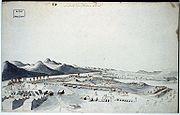
Two forts were built (c. 1731) near the current location of the town, Fort St. FrédéricFort St. Frédéric
Fort St. Frédéric was a French fort built on Lake Champlain at Crown Point to secure the region against British colonization and to allow the French to control the use of Lake Champlain....
by the French
France
The French Republic , The French Republic , The French Republic , (commonly known as France , is a unitary semi-presidential republic in Western Europe with several overseas territories and islands located on other continents and in the Indian, Pacific, and Atlantic oceans. Metropolitan France...
and later Fort Crown Point
Fort Crown Point
Crown Point, was a British fort built by the combined efforts of both British and Provincial troops in North America in 1759 at narrows on Lake Champlain on the border between modern New York State and Vermont...
by the British
Kingdom of Great Britain
The former Kingdom of Great Britain, sometimes described as the 'United Kingdom of Great Britain', That the Two Kingdoms of Scotland and England, shall upon the 1st May next ensuing the date hereof, and forever after, be United into One Kingdom by the Name of GREAT BRITAIN. was a sovereign...
.
During colonial times and the American Revolutionary War
American Revolutionary War
The American Revolutionary War , the American War of Independence, or simply the Revolutionary War, began as a war between the Kingdom of Great Britain and thirteen British colonies in North America, and ended in a global war between several European great powers.The war was the result of the...
, its strategic location often made Crown Point an important location. Situated on the west shore of Lake Champlain
Lake Champlain
Lake Champlain is a natural, freshwater lake in North America, located mainly within the borders of the United States but partially situated across the Canada—United States border in the Canadian province of Quebec.The New York portion of the Champlain Valley includes the eastern portions of...
about 15 miles north of Fort Ticonderoga
Fort Ticonderoga
Fort Ticonderoga, formerly Fort Carillon, is a large 18th-century fort built by the Canadians and the French at a narrows near the south end of Lake Champlain in upstate New York in the United States...
it provided a fortified position about a day's travel north of that site.
After the failure of the American Invasion of Canada
Invasion of Canada (1775)
The Invasion of Canada in 1775 was the first major military initiative by the newly formed Continental Army during the American Revolutionary War. The objective of the campaign was to gain military control of the British Province of Quebec, and convince the French-speaking Canadiens to join the...
in 1776, it represented the northernmost point of American control. During the British Saratoga Campaign
Saratoga campaign
The Saratoga Campaign was an attempt by Great Britain to gain military control of the strategically important Hudson River valley in 1777 during the American Revolutionary War...
in 1777, General Burgoyne
John Burgoyne
General John Burgoyne was a British army officer, politician and dramatist. He first saw action during the Seven Years' War when he participated in several battles, mostly notably during the Portugal Campaign of 1762....
organized a supply magazine here to support his attack of Ticonderoga.
The Town of Crown Point is an original town of the county, established in 1786 before Essex County was created. Parts of Crown Point were used to form the Towns of Elizabethtown
Elizabethtown, New York
Elizabethtown is a town in Essex County, New York, United States. The population was 1,315 at the 2000 census. The county seat of Essex County is a hamlet also called Elizabethtown. The name is derived from Elizabeth Gilliland, the wife of an early settler....
(1798) and Willsboro
Willsboro, New York
Willsboro is a town in Essex County, New York, in the United States, and lies thirty miles south of the city of Plattsburgh. As of the 2000 census, the town population was 1,903...
(1788).
The modern settlement of the town began around 1800 with an influx of settlers from Vermont
Vermont
Vermont is a state in the New England region of the northeastern United States of America. The state ranks 43rd in land area, , and 45th in total area. Its population according to the 2010 census, 630,337, is the second smallest in the country, larger only than Wyoming. It is the only New England...
.
Crown Point holds the New York state January record low of -48.
Geography
United States Census Bureau
The United States Census Bureau is the government agency that is responsible for the United States Census. It also gathers other national demographic and economic data...
, the town has a total area of 81.9 square miles (212.1 km²), of which, 76.3 square miles (197.6 km²) of it is land and 5.6 square miles (14.5 km²) of it (6.89%) is water.
The east town line, defined by Lake Champlain, is the border of Vermont
Vermont
Vermont is a state in the New England region of the northeastern United States of America. The state ranks 43rd in land area, , and 45th in total area. Its population according to the 2010 census, 630,337, is the second smallest in the country, larger only than Wyoming. It is the only New England...
(Addison County
Addison County, Vermont
Addison County is a county located in the U.S. state of Vermont. In 2010, the population was 36,821. Its shire town is Middlebury.-Geography:...
). The Champlain Bridge
Champlain Bridge (United States)
The Champlain Bridge was a long vehicular bridge in the United States that traversed Lake Champlain between Crown Point, New York and Chimney Point, Vermont. It was opened to traffic in 1929 as a toll bridge; the tolls were removed in 1987...
(Route 17) connected Crown Point to Vermont until 2009, when the bridge was demolished as unsafe. A temporary ferry service, operated by the Lake Champlain Transportation Company
Lake Champlain Transportation Company
The Lake Champlain Transportation Company provides car and passenger ferry service at four points on Lake Champlain in the United States. From 1976 to 2003, it was owned by Burlington, Vermont, businessman Raymond C. Pecor, Jr. who is Chairman of the company's board...
and funded by the States of New York and Vermont, currently provides access from Crown Point to Vermont. The new bridge at Crown Point is scheduled to open in August 2011.
Crown Point lies entirely within the Adirondack Park.
New York State Route 9N
New York State Route 9N
New York State Route 9N is a north–south state highway in northeastern New York, United States. It extends from an intersection with U.S. Route 9 , NY 29, and NY 50 in the city of Saratoga Springs to a junction with US 9 and NY 22 in the Clinton County village of...
, New York State Route 22
New York State Route 22
New York State Route 22 is a north–south state highway in eastern New York in the United States. It runs parallel to the state's eastern edge from the outskirts of New York City to a short distance south of the Canadian border. At , it is the state's longest north–south route and...
, and New York State Route 903 are north-south highways in Crown Point. NY-9N and NY-22 are conjoined through the town. NY-903 runs up the Crown Point peninsula.
Demographics
As of the censusCensus
A census is the procedure of systematically acquiring and recording information about the members of a given population. It is a regularly occurring and official count of a particular population. The term is used mostly in connection with national population and housing censuses; other common...
of 2000, there were 2,119 people, 797 households, and 578 families residing in the town. The population density
Population density
Population density is a measurement of population per unit area or unit volume. It is frequently applied to living organisms, and particularly to humans...
was 27.8 people per square mile (10.7/km²). There were 1,063 housing units at an average density of 13.9 per square mile (5.4/km²). The racial makeup of the town was 97.50% White, 0.09% African American, 0.24% Native American, 0.38% Asian, 0.14% from other races
Race (United States Census)
Race and ethnicity in the United States Census, as defined by the Federal Office of Management and Budget and the United States Census Bureau, are self-identification data items in which residents choose the race or races with which they most closely identify, and indicate whether or not they are...
, and 1.65% from two or more races. Hispanic or Latino of any race were 0.14% of the population.
There were 797 households out of which 33.9% had children under the age of 18 living with them, 58.2% were married couples
Marriage
Marriage is a social union or legal contract between people that creates kinship. It is an institution in which interpersonal relationships, usually intimate and sexual, are acknowledged in a variety of ways, depending on the culture or subculture in which it is found...
living together, 8.3% had a female householder with no husband present, and 27.4% were non-families. 21.3% of all households were made up of individuals and 9.8% had someone living alone who was 65 years of age or older. The average household size was 2.64 and the average family size was 3.06.
In the town the population was spread out with 28.0% under the age of 18, 6.7% from 18 to 24, 27.0% from 25 to 44, 23.8% from 45 to 64, and 14.4% who were 65 years of age or older. The median age was 38 years. For every 100 females there were 102.4 males. For every 100 females age 18 and over, there were 102.0 males.
The median income for a household in the town was $33,958, and the median income for a family was $39,853. Males had a median income of $31,106 versus $20,074 for females. The per capita income
Per capita income
Per capita income or income per person is a measure of mean income within an economic aggregate, such as a country or city. It is calculated by taking a measure of all sources of income in the aggregate and dividing it by the total population...
for the town was $16,692. About 10.8% of families and 14.6% of the population were below the poverty line, including 20.9% of those under age 18 and 9.6% of those age 65 or over....
Communities and locations in Crown Point
- Bulwagga Bay – A bayBayA bay is an area of water mostly surrounded by land. Bays generally have calmer waters than the surrounding sea, due to the surrounding land blocking some waves and often reducing winds. Bays also exist as an inlet in a lake or pond. A large bay may be called a gulf, a sea, a sound, or a bight...
between Crown Point peninsula and the mainland of the county. - Burdick Crossing – A hamlet in the northeast part of the town, near the south end of Crown Point on County Road 48.
- Cold Spring Park – A hamlet in the northeast part of the town on County Road 7.
- Crown Point – The hamletHamlet (place)A hamlet is usually a rural settlement which is too small to be considered a village, though sometimes the word is used for a different sort of community. Historically, when a hamlet became large enough to justify building a church, it was then classified as a village...
of Crown Point is in the eastern part of the town on Routes NY-9N and NY-22. - Crown Point – A peninsulaPeninsulaA peninsula is a piece of land that is bordered by water on three sides but connected to mainland. In many Germanic and Celtic languages and also in Baltic, Slavic and Hungarian, peninsulas are called "half-islands"....
in the south end of Lake Champlain and site some historic fortifications. - Crown Point Center – A hamlet west of Factoryville at the junction of County Roads 2 and 7.
- Crown Point State Historic SiteCrown Point State Historic SiteCrown Point State Historic Site is the site of a former military stronghold at the south end of the wider part of Lake Champlain. The location is in Essex County, New York, USA. The site is on a peninsula in the town of Crown Point, New York....
– A state park/historical site at the north tip of Crown Point peninsula. - Eagle Lake – A lake partly in the southwest part of the town.
- Factoryville – A hamlet west of Crown Point village.
- Ironville – A hamlet in the south part of the town on County Road 2 at the north end of Penfield Pond. It is the location of the Ironville Historic DistrictIronville Historic DistrictIronville Historic District is a national historic district located at Ironville in Essex County, New York. The district contains 12 contributing buildings. It encompasses the area associated with a once thriving iron works. Almost nothing remains of the iron works itself...
. - Penfield Pond – A lake partly inside Crown Point at the south town line.
- Putts Creek Wildlife Management AreaNew York State Wildlife Management AreasNew York State owns and maintains more than 85 Wildlife Management Areas , with a total area of more than .The Wildlife Management Areas Program is administered by the Division of Fish, Wildlife and Marine Resources of the Department of Environmental Conservation...
– A conservation area north of Crown Point village.