
Colorado River
Encyclopedia
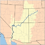
The Colorado River is a river
in the Southwestern United States
and northwestern Mexico
, approximately 2330 kilometres (1,447.8 mi) long, draining a part of the arid regions on the western slope of the Rocky Mountains
. The watershed
of the Colorado River covers 637000 km² (245,947.1 sq mi) in parts of seven U.S. state
s and two Mexican states. The natural course of the river flows from the Continental Divide
at La Poudre Pass
in Rocky Mountain National Park
, Colorado
, into the Gulf of California
between the Baja California peninsula
and mainland Mexico.
Large diversions of water for irrigation, and to a much lesser extent to supply cities combined with significant evaporation
losses from its reservoir
s have dewatered the lower course of the river downstream of Yuma, AZ, above the Colorado River Delta
, resulting in it no longer consistently reaching the Gulf of California. More than 20 major dams have been built on the Colorado River and its tributaries.
on the Continental Divide
at La Poudre Pass
, in Rocky Mountain National Park
, about 40 km (24.9 mi). north of Lake Granby
, as a tiny stream draining a wet meadow
. At the river's headwater
, the Continental Divide forms the boundary between the Gulf of Mexico
and Pacific Ocean
watersheds of North America
, between Colorado's
Grand
and Larimer
counties, and the northern boundary of Rocky Mountain National Park.
The river's first diversion is here at its headwater. The Grand Ditch
redirects water from the Never Summer Mountains
, which would have flowed into the Colorado River, to instead flow across the divide through La Poudre Pass to irrigate farmland to the east.
About a mile (1.5 km) downstream from its source, the Colorado River has carved its first canyon, the narrow, deep Little Yellowstone Canyon. It then flows through the broad Kawuneeche Valley, where it is joined by U.S. Highway 34, which will roughly parallel it to the town of Granby
. It finally exits Rocky Mountain National Park, flowing into Shadow Mountain Lake
and then into Lake Granby
, which are portions of the Colorado-Big Thompson Project
, a large trans-basin water storage and delivery project that diverts water from the Colorado River under the Front Range
mountains to provide an agricultural and municipal water supply
for the northern Front Range
and plains of Colorado.
Starting in Granby, the river is roughly paralleled by U.S. Highway 40 to the town of Kremmling
, and by the tracks of the Union Pacific Railroad
until about the Utah
border, carrying the Amtrak
California Zephyr
passenger train. The canyons and valleys of the Upper Colorado River are among the scenic attractions for passengers on this rail route.
Just downstream from Granby, the Colorado is joined by the Fraser River
. At Hot Sulphur Springs
the river flows through Byers Canyon
and then is joined by the Williams Fork
. Just below Kremmling
it is joined by the Blue River
before flowing through Gore Canyon
, famous for its challenging rapids for the sport of whitewater rafting
, and where it drops significantly until Colorado State Highway 131
crosses at the village of State Bridge. It meets the Eagle River
in the town of Dotsero
, from where Interstate 70
will parallel the Colorado almost until it enters Utah
.
It then flows through Glenwood Canyon
, emerging at the city of Glenwood Springs
where it is joined by the swift flowing Roaring Fork River
. West of Glenwood Springs, the Colorado runs through De Beque Canyon
and the Grand Valley
and is joined by the Gunnison River
at Grand Junction
. Though many of the river's uppermost tributaries within Colorado are small, there are exceptions, such as the Gunnison and Roaring Fork Rivers, in which massive amounts of water flow. From there it flows in an arc west-north through Ruby Canyon
, where it crosses the Utah
state line, into Westwater Canyon
. Here, the Colorado ranges from 200 to 1200 ft (61 to 365.8 m) wide and from 6 to 30 ft (1.8 to 9.1 m) in depth with occasional deeper areas.
 The river turns southwest near Fruita, Colorado, and is joined by the Dolores River
soon after entering Utah. It partially forms the southern border of Arches National Park
near Moab, Utah
, and then passes by Dead Horse Point State Park
and through Canyonlands National Park
where it is met by one of its primary tributaries, the Green River
. The Colorado River then flows into Lake Powell
, formed by the Glen Canyon Dam
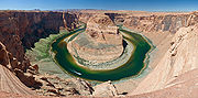
, where the San Juan River joins. Below the dam, water released from the bottom of Lake Powell makes the river clear, clean, and cold. Just south of the town of Page
, Arizona
, the river forms the dramatic Horseshoe Bend
, then at Lees Ferry is joined by another tributary, the warm, shallow, muddy Paria River
, and begins its course through Marble Canyon
. Here, the Colorado River ranges from 175 to 700 ft (53.3 to 213.4 m) in width and 9 to 130 ft (2.7 to 39.6 m) in depth.
At the southern end of Marble Canyon
, the river is joined by another tributary, the Little Colorado River
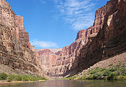
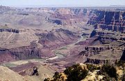
, and the river then turns abruptly west directly across the folds and fault line of the plateau, through Grand Canyon
and Grand Canyon National Park
, which is 349 km long (217 miles) and from 6 to 30 km (4 to 20 miles) between the upper cliffs. The walls, 4000 to 6000 ft (1,219.2 to 1,828.8 m) high, drop in successive escarpments of 500 to 1600 ft (152.4 to 487.7 m), banded in splendid colors toward the narrow gorge of the present river.
Below the confluence of the Virgin River
in Nevada
, the Colorado River abruptly turns southward. Hoover Dam
, built during the Great Depression, forms Lake Mead
, a popular recreation site as well as the supplier of most of the water for the Las Vegas metropolitan area
. From Hoover Dam, the river flows south and forms part of the boundary between Arizona
and Nevada
and between Arizona and California
. Along the California-Arizona reach of the river, four additional dams are operated to divert water for municipal supplies and agricultural irrigation, and for recreational uses. Lake Mohave
, formed by Davis Dam
, lies in the southern portion of the Lake Mead
National Recreation Area. Lake Havasu
, formed by Parker Dam
, provides recreation as well as the home of the retired U.K. London Bridge
, now the New London Bridge
. The two remaining dams supply irrigation water: Palo Verde Diversion Dam and Imperial Dam
. Here, the Colorado River ranges in width from 700 to 2500 ft (213.4 to 762 m) and from 8 to 100 ft (2.4 to 30.5 m) in depth.
the river lessens in gradient and in its lower course flows through the Colorado Desert
in a broad sedimentary valley's distinct estuarine plain upriver from Yuma
, where it is joined by the Gila River
. The channel through much of this region is bedded in a dike-like embankment lying above the floodplain over which the escaping water spills in time of flood. This dike cuts off the flow of the river to the remarkable low area in southern California known as the Salton Sink
in the Coachella Valley
, and the Imperial Valley. The Salton Sink and its Salton Sea
are located below sea level; therefore, the descent from the river near Yuma is very much greater than the descent from Yuma to the Gulf of California
.
The lower course of the river—which forms the border between the Mexican state of Sonora
on the mainland and the state of Baja California
on the Baja California peninsula
—is a dry or small stream most of the year due to the river being diverted into the Imperial Valley's irrigation source, the All-American Canal
. Several miles from its mouth, the Hardy River
enters, adding a little water to the often dry Colorado before it reaches the Gulf of California.
Prior to the mid 20th century, the Colorado River Delta
provided a rich estuarine marshland; while today it is now essentially desiccated, the river is still an important ecological estuary
resource. The estuary of the Colorado River was subjected to a major tidal bore
that has almost disappeared with the drastic reduction in the freshwater flow following the irrigation diversions of the Colorado River, and to a lesser extent because of some dredging of the estuary channel. The first historical record of the tidal bore was that of the Croatia
n missionary in Spanish service Father Ferdinand Konščak
on 18 July 1746. During spring tide conditions, the tidal bore formed in the estuary about Montague Island
and propagated upstream. It was called locally 'El Burro' or 'burro
'. Today the tidal bore is rarely seen although there are still some anecdotal observations.
along its lower course. The diversions are principally responsible for reducing the average flow of the Colorado near its mouth from about 22000 cuft/s between 1903 and 1934 to less than 4000 cuft/s from 1951 to 1980. Annual flow near the river's mouth in 1984 was 17500 cuft/s due to record-breaking precipitation. From 1975 to 2004 the average flow at the US–Mexico border was 2661 cuft/s.
The United States Geological Survey
(USGS) operates a number of stream gauge
s along the Colorado River. A gauge on its middle course, at Lee's Ferry
, 25.6 kilometres (15.9 mi) below Glen Canyon Dam
, recorded an average discharge
of 17850 cuft/s between 1895 and 2009. The maximum flow recorded at this station was 220000 cuft/s on June 18, 1921. The minimum flow was 700 cuft/s, January 23–24, 1963, resulting from the initial closure of Glen Canyon Dam. The mean annual discharge recorded by downriver gauges are all lower than at the Lee's Ferry gauge, and includes 13860 cuft/s below Hoover Dam
, 14190 cuft/s below Davis Dam
, 12040 cuft/s below Parker Dam
, 1724 cuft/s below the Laguna Diversion Dam
, and 1988 cuft/s, for 2008–2009, at the Northerly International Boundary (NIB) with Mexico, 1.8 kilometres (1.1 mi) above Morelos Dam
. This NIB gauge has operated since 1950 and is, via the International Boundary and Water Commission
, the accounting point for the 1944 International Treaty detailing water delivery to Mexico.
The last stream gauge is at the Southerly International Boundary (SIB), where the river leaves the United States altogether. Although the river flows about 123 kilometres (76.4 mi) from the SIB to its mouth, no discharge data has been collected since 1983. The amount of water that reaches the mouth of the Colorado River is not known. It is often estimated to be similar to that recorded at the SIB even though this is probably inaccurate. Accounts of flow below the SIB range from zero to a level equal to that recorded at the SIB. The average annual discharge at the SIB from 1975 to 2004 was 1928000 acre.ft. During that period's 18 "non-surplus" years the flow at the SIB was only 865000 acre.ft per year. There has been no measurable flow at all at the SIB for extended periods during many years. In 1996 no flow was recorded on any day of the entire year. Nonetheless, a small amount of water flows into the Colorado River below the SIB, mostly from irrigation returns
, the Hardy River
, and effluent
from the cities of San Luis Río Colorado
and Mexicali
.
period, the southwestern United States was still part of the Western Interior Seaway
and the Pacific Ocean
. It was only when the Farallon Plate
was subducted under the North American Plate
in what is now known as the Laramide orogeny
about 75 million years ago, did the Rocky Mountains thrust out of the flat seascape, and thus the Colorado River was born. The Upper Colorado, Gunnison
, and San Juan Rivers all formed in this way. However, instead of cutting southwest across the Colorado Plateau to the Gulf of California, the Colorado was instead diverted northeast into present-day Wyoming by the Colorado Plateau to join the headwaters of the North Platte River
. Later, with the uplift of mountain ranges in northern Utah and southern Wyoming, the Colorado was instead diverted eastwards, into the Great Basin
, where in flood, it would sometimes reach the Snake River
.
During the Miocene
, the lower course of the river began to form, completely independent of the upper Colorado. It began as the entrenched gorge of the Kanab Creek
, a northern tributary of the Colorado in the present-day Grand Canyon. The waters from the Colorado Plateau flowed into the Kanab, joining other tributaries and flowing westwards across present-day Central California
, flowing into the Pacific at Monterey Bay
where it is believed to have been responsible for creating the Monterey submarine canyon
and its associated alluvial fan
. Over millions of years, this entirely independent river slowly eroded what would become the western half of the Grand Canyon. Meanwhile, the Little Colorado River
's drainage path formed in the Painted Desert
, emptying into a large endorheic basin in northeastern Arizona, Hopi Lake, where it usually terminated excepting during floods. The upper Colorado River changed course between the Great Basin and the Colorado Plateau several times, cutting Marble Canyon
and Glen Canyon
in a northwesterly direction as it emptied back into the Great Basin, in the opposite direction of which the water now flows. Later, tectonic activity helped to tilt the land such that the flow in Marble and Glen Canyons reversed to the southwest. This explains why many of the present-day tributaries in this section, such as the Little Colorado, flow into the river at obtuse angles i.e. opposite to the river's present flow direction.
The most widely believed theory is that the Colorado had been continually flowing across the Plateau for about 65 million years, slowly and steadily eroding the Grand Canyon. However, an alternative theory is that roughly 5.4 million years ago, the Colorado's flow again shifted into Hopi Lake. Hopi Lake overflowed across the Colorado Plateau in a massive flood, eroding the Grand Canyon in a much shorter time period than previously believed. Either way, uplift of the high mountain ranges in California, such as the Sierra Nevada, Tehachapis
, and Transverse Ranges
then blocked the path of the Colorado and diverted it southwards into the Gulf of California, where it began to build a vast delta
. This delta eventually walled off the northern part of the Gulf of California from the rest of the body of water, creating the Salton Sink
, which dried up except when the Colorado changed course to empty into the basin, as it did in 1904 creating the Salton Sea
.
began to populate the area around the Green River and the eastern part of the Great Basin
. It was not until about 700 A.D. that the ancestral Puebloans began to cultivate crops for food, and the famous cliff dwellings for which they are best known did not come into being until past 1000 A.D.
Native American groups such as the Anasazi, Navajo
, Pueblo and Hohokam
Indians later lived on the arid lands of the Colorado Plateau, using water from the Colorado and its tributaries for irrigation
. These two native groups formed large agriculture
-based societies which each only lasted for a few hundred years, starting from around 200 B.C. The Anasazi inhabited the northern part of the Plateau and the foothills of the Rockies, in areas such as Chaco Canyon near the San Juan and Green
Rivers, while the Hohokam lived in present-day central Arizona in the Gila River
valley around the confluence with the Salt River
. Both the Anasazi and Hohokam utilized extensive systems of canals to water their farmland, with over 352 kilometres (218.7 mi) utilized by the Hohokam alone.
Native civilization reached its peak from 600 to 900 A.D. in the Colorado watershed, but began a general decline afterwards. Around the 13th century and 14th century, near the height of a second peak, the Anasazi and Hohokam cultures suddenly "disappeared" from the lands around the Colorado River. Their demise is believed to be linked to the overuse of water for irrigation combined with a severe half-century drought
. Intensive irrigation raised the water table
while increasing the salinity
of the soils used for farming, eventually making them unsuitable. Flash flood
s during the 12th century and 13th century were probably responsible for the demise of the Chaco culture, and the Navajo and Puebloan people who lived in the high desert in the Four Corners region near present-day Lake Powell
declined as well.
It is believed that during the severe droughts of the three centuries surrounding the 13th century, many of the peoples that once inhabited the upper regions of the Colorado watershed migrated to the Rio Grande
valley and the Painted Desert
in the Little Colorado River
region. Many of the people in the Hopi
and Zuni tribes of the Sonoran Desert
, as well as the Acoma
and Laguna
people on the Rio Grande, are believed to be descended from the ancient inhabitants of the northeastern Colorado Plateau.
sailed to the head of the Gulf of California
and rowed a short distance upstream. It was next seen by Hernando de Alarcon
who in 1540 led the maritime contingent of Coronado's expedition. The plan was to meet the land based force and resupply them. Alarcon ascended the river about 85 miles to the limit of navigation near present-day Yuma
, Arizona
. He waited for Coronado, but eventually despaired, cached some supplies and correspondence, left a note on a tree, and departed. Coronado's land forces never reached that location, but Melchior Diaz, on his third expedition, went to see if he could establish contact with Alarcon. By the time he reached the Colorado, however, Alarcon had already left. The Native Americans told him what they knew of Alarcon's presence and that he had left a cache of supplies. Diaz found the note and the supplies. Diaz named the river Rio del Tizon ("River of Embers" or "Firebrand River") based on a practice used by the natives for warming themselves. Meanwhile, Coronado (who at the time was near Zuni, New Mexico) had learned from one of his scouting parties that the natives spoke of a large river to the west. He sent Garcia Lopez de Cardenas
to lead a contingent of men to find this river. They did find it at what is now known as the Grand Canyon
, becoming the first people of European background to see it. Their failed attempts at reaching the river led them to conclude that it would not be possible to be supplied via the Gulf of California and the river.
 The following year, Francisco de Bolaños sailed to the mouth of the river on the Gulf of California. One of his pilots, Domingo del Castillo, prepared a map of the Mexican coast. He charted three rivers at the head of the gulf and named them Brazo de laguna p., Rio de buena Guia p., and Brazo de Mira flores p.. The latter of these three is the longest. Later references suggest that Brazo de Mira flores referred to what is now called the Gila River
, and that Rio de buena Guia was his name for the Colorado. In spite of these records, the legend and mapmaking error showing an Island of California
persisted for more than a century, especially among European cartographers.
Comparisons of 17th, 18th, and early 19th-century maps reveal a parade of names being applied to the Colorado and its tributaries, as well as a variety of courses, as cartographers learned or made up the geography of the region. On a map by Nicholas Sanson (1650) the R. del Tecon and the R. de Coral share a common mouth on the gulf. A number of maps show the Gila River (sometimes just the lower, sometimes the whole) as the Rio Grande de las Apostoles. A 1763 map by Emanuel Bowen
equates the Apostles with the del Coral. A 1720 map by Fer Nicholas labels the main body of the Colorado as Rio del Tison, and a tributary of the Apostles/Gila as Rio Colorade. In 1703 Guillaume de L'Isle showed a Rio de buena esperanza as a major tributary of the Tison, but it is not clear if this tributary corresponds better with the Little Colorado or the San Juan. A map by Herman Moll (1720) charts the Tison and the Gila with separate mouths. Upriver from a tributary of the Tison that would appear to correspond with today's Virgin River, the name for the main channel is given as R. of Good Hope. On other maps Good Hope/Buena Esperanza are transferred to a tributary of the Gila. A map of 1757 gives the name of the main course as Rio Colorado de los Martyres. A map of 1781 by Jonathan Carver charts a major split in the river and labels the eastern branch "Colorado" and the western branch Martyres. A map from 1758 by Didier Robert de Vaugondy
applies the name Colorado to a river that reaches north to the headwaters of the Missouri, best corresponding to today's Green River. When Jedediah Smith first reached the lower Colorado in 1826, he first called it the Seedskeedee, as the headwaters of the Green River were known to the trappers, but also noted that the natives called it the Colorado.
 It is not clear when or why the name "Colorado" first replaced "Tizon" (Tecon/Tison), which had been the most common name on maps since 1540. Among the maps in the Library of Congress
, every use of "Colorado" (or Colorade) from 1720 and before is applied to a tributary of what is now the Gila River that seems best to correspond with today's Verde River
. The earliest map in that collection that replaces "Tizon" with "Colorado" is a map from 1743.
The map that resulted from Escalante's expedition in 1776 labels the main channel as the Colorado up to the confluence of the Nabajoo and Zaguananas rivers. The associated information leads one to conclude that the Nabajoo corresponds to the San Juan and the Zaguananas to the Colorado from there to the Dolores River. On this map the Colorado above the Dolores is called the Rafael, and the Green River (named Buenaventura River) is erroneously diverted to the southwest and to what is now called Sevier Lake. Where Escalante's journal records his crossing of the San Rafael, he notes that the Native Americans knew this river as the Colorado. He also notes that the natives said this river had it source in a distant lake, but the lake is not charted on the resulting map. It is evident from a number of maps of the period that people were not aware of the distance between the Colorado's confluence with the Dolores and the western slopes of the Front Range
. On a map from 1847 by John Disturnell, the Rafael is replaced with the Green River, while the upper Colorado (or more correctly, what would be called the Grand River) is not shown at all.
to its confluence with the Green River
in Utah
from about 1836 to 1921. This gave rise to several now orphaned names including Grand Lake
, Grand Valley
, Grand Junction
, Grand County, Colorado
, and Grand County, Utah
. The earliest appearance of this name on a map could be on the map by Henry Schenck Tanner (1836). The name there replaces the name of Rio Rafael, which appears on many earlier maps. The head of this branch of the Colorado is shown as at about the same latitude as Longs Peak
in Colorado. There is nothing charted that corresponds to the Green River, nothing that corresponds with the course of the Dolores (even though some earlier maps did show the Dolores with reasonable accuracy), and the headwaters of both the Rio Grande ("Rio del Norte") and especially the Arkansas River are shown to reach to a higher latitude.
A map by David H. Burr (1839) shows the "Colorado River of the West" flowing from the headwaters of the Green River to the Gulf of California, with the "Grand River" as a tributary branching to the east, the third tributary upriver from the Nabajoo (San Juan). The Green River is not separately named. The headwaters of the Grand are depicted as being very close to the headwaters of the Rio Grande (which is labeled "Rio Bravo del Norte") as well as those of the Arkansas River. A textual note on the map indicates that little is known of this area. In 1859, a U.S. Army topographic
expedition led by Captain John Macomb located the confluence of the Green River with the Grand River in what is now Canyonlands National Park
. The Macomb party designated the confluence as the source of the Colorado River.
In 1921, U.S. Representative Edward T. Taylor
petitioned the Congressional Committee on Interstate and Foreign Commerce
to rename the Grand River as the Colorado River. On July 25, 1921 the name change was made official in House Joint Resolution 460 of the 66th Congress
, over the objections of representatives from Wyoming
and Utah
and the United States Geological Survey
which noted that the drainage basin of the Green River was more than 70% more extensive than that of the Grand River, although the Grand carried a slightly higher volume of water at its confluence with the Green.
Note that the significant difference between the present height of the rim of the Grand Canyon
(about 2440 m; 8000 ft) and the levels at which the river enters/exits it gives rise to the geologic theory that uplift must have begun around the same time the river began flowing through it and eroding it (since rivers do not run uphill, it would have otherwise followed some other path around the uplifted region). Estimates for the beginning of this erosion/uplift process range from 5 to 70 million years ago.
 In the autumn of 1904, the river's waters escaped into a diversion canal
a few miles below Yuma, Arizona
, creating the New River and Alamo River
, and over two years re-formed the Salton Sea in the Salton Sink
of California's Coachella Valley
. The river re-created the Salton Sea
, a great inland sea in the Salton Sink
, an area that it had frequently inundated before. For example, in 1884 and 1891 the river practically abandoned its regular course through Mexico to the Gulf of California, and flowed into the Salton Sink. However, it was effectively dammed in the early part of 1907 and it returned to its normal course, although from which there was still much leakage to the Salton Sea. In July 1907 the permanent dam was completed, keeping the Colorado's usually normal course from the Black Canyon through the Colorado Desert
basin towards the Gulf of California.
The Colorado River is a major and in some cases life-sustaining source of water for irrigation, drinking, and other uses by people living in the arid American southwest. Allocation of the river's water is governed by the Colorado River Compact
, a 1922 agreement towards seven U.S. states in the Colorado River basin governing the allocation of the water rights to the river's water among the parties of the interstate compact. More than ten dams have been built along the river, beginning with Shadow Mountain Dam
in western Colorado and ending with Morelos Dam
on Arizona's border with Baja California. The first dam on the Colorado, Hoover Dam
(originally Boulder Dam, and the largest in the world upon completion) was finished in 1936. Its impoundment of the river in the Mojave Desert
creates Lake Mead
, which provides water for irrigation and the generation of hydroelectric power. Since the completion of dams, the majority of the river in normal hydrologic years is diverted for agricultural and municipal water supply. The Colorado's last drops evaporate in the Sonoran Desert
, more than 60 miles (96.6 km) before the river reaches the Gulf of California.
 Almost 90% of all water diverted from the river is for irrigation purposes. The All-American Canal
is the largest irrigation canal in the world and carries a volume of water from 420 to 850 m³/s (15,000 to 30,000 ft³/s), making it larger in volume than New York
's Hudson River
. The canal's waters are used to irrigate the fertile Imperial Valley orchards and crops, formerly a Sonoran Desert
ecosystem where several years can pass between measurable rainfalls. Hydrology transport models are used to assess management of the river's flow and water quality.
Several cities such as Phoenix
and Tucson
(Central Arizona Project-CAP), Los Angeles
and San Bernardino
(Colorado River aqueduct
), Las Vegas, Nevada
, and San Diego, California
have aqueducts leading all the way back to the Colorado River. The Central Arizona Project (CAP) canal, which was begun in the 1970s and finished in the 1990s, begins at Parker Dam and runs all the way to Phoenix and then Tucson to supplement those cities' water needs.
The lower Colorado is navigable by moderate to large-sized craft. The lower river from Davis Dam to Yuma is navigable by large paddlewheel boats and river barges, but commercial navigation on the river is unimportant because the river is cut off from the sea, making other means of transportation more efficient in the region. Before the railroads arrived, the lower Colorado River from the sea to near present-day Laughlin, Nevada
was an important means of transportation via large steamers. Most of the rest of the river (and reservoirs), excluding the rapids in the canyons, is navigable by small to moderate-sized river craft and power boats.
and endangered
: Colorado pikeminnow (formerly Colorado squawfish), razorback sucker
, bonytail chub, and humpback chub. The Upper Colorado River Endangered Fish Recovery Program
is a controversial effort by the US Fish and Wildlife Service
, in conjunction with the Arizona Game and Fish Department
, the Colorado Division of Wildlife, and the Utah Department of Wildlife to recover these endangered fish.
Fish species in the river are Brook Trout
, Blue Catfish
, Catfish (Channel)
, Carp
, Crappie
, Largemouth Bass
, Rainbow Trout
, Striped Bass
, Sunfish
, Sturgeon
, Colorado Pikeminnow
, Humpback Chub
, Razorback Sucker
, Bonytail Chub
, Tilapia
, Smallmouth bass
Black Bullhead Catfish and Flathead Catfish
processing mill in the area of Moab, Utah
, on the north bank of the Colorado River just under 5 km (about 3 miles) from downtown Moab. As a byproduct of uranium processing activities, an estimated 16 million ton pile of chemically and radioactively hazardous tailings
exists. The pile is located about 700–800 feet (200–250 meters) from the Colorado River. Although no contamination has been detected, the proximity of the material to the watershed has been a concern. The Senate has authorized the U.S. Department of Energy to budget $22.8 million in 2007 to begin the project of moving the uranium tailings farther from the river. The plan is to move the contaminated materials 48 kilometres (29.8 mi) north to a disposal site located at Crescent Junction, Utah. The project is expected to be completed by 2028 with current funding plans, at total estimated cost of US$720 million.
River
A river is a natural watercourse, usually freshwater, flowing towards an ocean, a lake, a sea, or another river. In a few cases, a river simply flows into the ground or dries up completely before reaching another body of water. Small rivers may also be called by several other names, including...
in the Southwestern United States
Southwestern United States
The Southwestern United States is a region defined in different ways by different sources. Broad definitions include nearly a quarter of the United States, including Arizona, California, Colorado, Nevada, New Mexico, Oklahoma, Texas and Utah...
and northwestern Mexico
Mexico
The United Mexican States , commonly known as Mexico , is a federal constitutional republic in North America. It is bordered on the north by the United States; on the south and west by the Pacific Ocean; on the southeast by Guatemala, Belize, and the Caribbean Sea; and on the east by the Gulf of...
, approximately 2330 kilometres (1,447.8 mi) long, draining a part of the arid regions on the western slope of the Rocky Mountains
Rocky Mountains
The Rocky Mountains are a major mountain range in western North America. The Rocky Mountains stretch more than from the northernmost part of British Columbia, in western Canada, to New Mexico, in the southwestern United States...
. The watershed
Drainage basin
A drainage basin is an extent or an area of land where surface water from rain and melting snow or ice converges to a single point, usually the exit of the basin, where the waters join another waterbody, such as a river, lake, reservoir, estuary, wetland, sea, or ocean...
of the Colorado River covers 637000 km² (245,947.1 sq mi) in parts of seven U.S. state
U.S. state
A U.S. state is any one of the 50 federated states of the United States of America that share sovereignty with the federal government. Because of this shared sovereignty, an American is a citizen both of the federal entity and of his or her state of domicile. Four states use the official title of...
s and two Mexican states. The natural course of the river flows from the Continental Divide
Continental Divide
The Continental Divide of the Americas, or merely the Continental Gulf of Division or Great Divide, is the name given to the principal, and largely mountainous, hydrological divide of the Americas that separates the watersheds that drain into the Pacific Ocean from those river systems that drain...
at La Poudre Pass
La Poudre Pass
La Poudre Pass elevation is a high mountain pass located in the Rocky Mountains of northern Colorado in the United States.The pass straddles the Continental Divide, and separates the headwaters of La Poudre Pass Creek, which flows into the Atlantic Ocean, from the headwaters of the Colorado...
in Rocky Mountain National Park
Rocky Mountain National Park
Rocky Mountain National Park is a national park located in the north-central region of the U.S. state of Colorado.It features majestic mountain views, a variety of wildlife, varied climates and environments—from wooded forests to mountain tundra—and easy access to back-country trails...
, Colorado
Colorado
Colorado is a U.S. state that encompasses much of the Rocky Mountains as well as the northeastern portion of the Colorado Plateau and the western edge of the Great Plains...
, into the Gulf of California
Gulf of California
The Gulf of California is a body of water that separates the Baja California Peninsula from the Mexican mainland...
between the Baja California peninsula
Baja California Peninsula
The Baja California peninsula , is a peninsula in northwestern Mexico. Its land mass separates the Pacific Ocean from the Gulf of California. The Peninsula extends from Mexicali, Baja California in the north to Cabo San Lucas, Baja California Sur in the south.The total area of the Baja California...
and mainland Mexico.
Large diversions of water for irrigation, and to a much lesser extent to supply cities combined with significant evaporation
Evaporation
Evaporation is a type of vaporization of a liquid that occurs only on the surface of a liquid. The other type of vaporization is boiling, which, instead, occurs on the entire mass of the liquid....
losses from its reservoir
Reservoir
A reservoir , artificial lake or dam is used to store water.Reservoirs may be created in river valleys by the construction of a dam or may be built by excavation in the ground or by conventional construction techniques such as brickwork or cast concrete.The term reservoir may also be used to...
s have dewatered the lower course of the river downstream of Yuma, AZ, above the Colorado River Delta
Colorado River Delta
The Colorado River Delta is the region where the Colorado River flows into the Gulf of California . The delta is part of a larger geologic region called the Salton Trough. Historically, the interaction of the river’s flow and the ocean’s tide created a dynamic environment, supporting freshwater,...
, resulting in it no longer consistently reaching the Gulf of California. More than 20 major dams have been built on the Colorado River and its tributaries.
Headwaters
The Colorado River risesSource (river or stream)
The source or headwaters of a river or stream is the place from which the water in the river or stream originates.-Definition:There is no universally agreed upon definition for determining a stream's source...
on the Continental Divide
Continental Divide
The Continental Divide of the Americas, or merely the Continental Gulf of Division or Great Divide, is the name given to the principal, and largely mountainous, hydrological divide of the Americas that separates the watersheds that drain into the Pacific Ocean from those river systems that drain...
at La Poudre Pass
La Poudre Pass
La Poudre Pass elevation is a high mountain pass located in the Rocky Mountains of northern Colorado in the United States.The pass straddles the Continental Divide, and separates the headwaters of La Poudre Pass Creek, which flows into the Atlantic Ocean, from the headwaters of the Colorado...
, in Rocky Mountain National Park
Rocky Mountain National Park
Rocky Mountain National Park is a national park located in the north-central region of the U.S. state of Colorado.It features majestic mountain views, a variety of wildlife, varied climates and environments—from wooded forests to mountain tundra—and easy access to back-country trails...
, about 40 km (24.9 mi). north of Lake Granby
Lake Granby
Lake Granby is the second largest body of water in Colorado. It was created as part of the Colorado-Big Thompson Project and forms a continuous body of water with Shadow Mountain Reservoir and Grand Lake. On its own, Lake Granby contains approximately 40 miles of shoreline. The lake is popular...
, as a tiny stream draining a wet meadow
Wet meadow
A wet meadow is a semi-wetland meadow which is saturated with water throughout much of the year. Wet meadows may occur because of poor drainage or the receipt of large amounts of water from rain or melted snow. They may also occur in riparian zones....
. At the river's headwater
Source (river or stream)
The source or headwaters of a river or stream is the place from which the water in the river or stream originates.-Definition:There is no universally agreed upon definition for determining a stream's source...
, the Continental Divide forms the boundary between the Gulf of Mexico
Gulf of Mexico
The Gulf of Mexico is a partially landlocked ocean basin largely surrounded by the North American continent and the island of Cuba. It is bounded on the northeast, north and northwest by the Gulf Coast of the United States, on the southwest and south by Mexico, and on the southeast by Cuba. In...
and Pacific Ocean
Pacific Ocean
The Pacific Ocean is the largest of the Earth's oceanic divisions. It extends from the Arctic in the north to the Southern Ocean in the south, bounded by Asia and Australia in the west, and the Americas in the east.At 165.2 million square kilometres in area, this largest division of the World...
watersheds of North America
North America
North America is a continent wholly within the Northern Hemisphere and almost wholly within the Western Hemisphere. It is also considered a northern subcontinent of the Americas...
, between Colorado's
Colorado
Colorado is a U.S. state that encompasses much of the Rocky Mountains as well as the northeastern portion of the Colorado Plateau and the western edge of the Great Plains...
Grand
Grand County, Colorado
Grand County is the 21st largest of the 64 counties of the State of Colorado of the United States. The county population was 12,442 at U.S. Census 2000...
and Larimer
Larimer County, Colorado
Larimer County is the seventh most populous and the ninth most extensive of the 64 counties of the State of Colorado of the United States. The county is located at the northern end of the Front Range, at the edge of the Colorado Eastern Plains along the border with Wyoming...
counties, and the northern boundary of Rocky Mountain National Park.
The river's first diversion is here at its headwater. The Grand Ditch
Grand Ditch
The Grand Ditch, also known as the Grand River Ditch and originally known as the North Grand River Ditch, is a water diversion project in the Never Summer Mountains, in northern Colorado . It is long, wide, and deep on average...
redirects water from the Never Summer Mountains
Never Summer Mountains
The Never Summer Mountains are a mountain range in the Rocky Mountains in north central Colorado in the United States. The range is located along the northwest border of Rocky Mountain National Park, forming the continental divide between the headwaters of the Colorado River in Rocky Mountain...
, which would have flowed into the Colorado River, to instead flow across the divide through La Poudre Pass to irrigate farmland to the east.
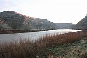
About a mile (1.5 km) downstream from its source, the Colorado River has carved its first canyon, the narrow, deep Little Yellowstone Canyon. It then flows through the broad Kawuneeche Valley, where it is joined by U.S. Highway 34, which will roughly parallel it to the town of Granby
Granby, Colorado
The Town of Granby is a Statutory Town that is the most populous town in Grand County, Colorado, United States. Granby is situated along U.S. Highway 40 in Middle Park about west of Denver, Colorado, southwest of Rocky Mountain National Park...
. It finally exits Rocky Mountain National Park, flowing into Shadow Mountain Lake
Shadow Mountain Lake
Shadow Mountain Lake is a reservoir in Grand County, Colorado, near the headwaters of the Colorado River. Shadow Mountain Lake is created by Shadow Mountain Dam...
and then into Lake Granby
Lake Granby
Lake Granby is the second largest body of water in Colorado. It was created as part of the Colorado-Big Thompson Project and forms a continuous body of water with Shadow Mountain Reservoir and Grand Lake. On its own, Lake Granby contains approximately 40 miles of shoreline. The lake is popular...
, which are portions of the Colorado-Big Thompson Project
Colorado-Big Thompson project
The Colorado-Big Thompson Project is a water diversion project in Colorado designed to collect West Slope mountain water from the headwaters of the Colorado River and divert it to Colorado's Front Range and plains...
, a large trans-basin water storage and delivery project that diverts water from the Colorado River under the Front Range
Front Range
The Front Range is a mountain range of the Southern Rocky Mountains of North America located in the north-central portion of the U.S. State of Colorado and southeastern portion of the U.S. State of Wyoming. It is the first mountain range encountered moving west along the 40th parallel north across...
mountains to provide an agricultural and municipal water supply
Water supply
Water supply is the provision of water by public utilities, commercial organisations, community endeavours or by individuals, usually via a system of pumps and pipes...
for the northern Front Range
Front Range
The Front Range is a mountain range of the Southern Rocky Mountains of North America located in the north-central portion of the U.S. State of Colorado and southeastern portion of the U.S. State of Wyoming. It is the first mountain range encountered moving west along the 40th parallel north across...
and plains of Colorado.
Starting in Granby, the river is roughly paralleled by U.S. Highway 40 to the town of Kremmling
Kremmling, Colorado
Kremmling is a Statutory Town in Grand County, Colorado, United States. The population was 1,578 at the 2000 census. The town sits along the upper Colorado River in the lower arid section of Middle Park between Byers Canyon and Gore Canyon...
, and by the tracks of the Union Pacific Railroad
Union Pacific Railroad
The Union Pacific Railroad , headquartered in Omaha, Nebraska, is the largest railroad network in the United States. James R. Young is president, CEO and Chairman....
until about the Utah
Utah
Utah is a state in the Western United States. It was the 45th state to join the Union, on January 4, 1896. Approximately 80% of Utah's 2,763,885 people live along the Wasatch Front, centering on Salt Lake City. This leaves vast expanses of the state nearly uninhabited, making the population the...
border, carrying the Amtrak
Amtrak
The National Railroad Passenger Corporation, doing business as Amtrak , is a government-owned corporation that was organized on May 1, 1971, to provide intercity passenger train service in the United States. "Amtrak" is a portmanteau of the words "America" and "track". It is headquartered at Union...
California Zephyr
California Zephyr
The California Zephyr is a long passenger train route operated by Amtrak in the midwestern and western United States.It runs from Chicago, Illinois, in the east to Emeryville, California, in the west, passing through the states of Illinois, Iowa, Nebraska, Colorado, Utah, Nevada, and California...
passenger train. The canyons and valleys of the Upper Colorado River are among the scenic attractions for passengers on this rail route.
Just downstream from Granby, the Colorado is joined by the Fraser River
Fraser River (Colorado)
The Fraser River is a tributary of the Colorado River, approximately long, in north central Colorado in the United States. It drains large portion of the Middle Park basin in Grand County in the Rocky Mountains west of Boulder and southwest of Rocky Mountain National Park. It rises at the...
. At Hot Sulphur Springs
Hot Sulphur Springs, Colorado
The Town of Hot Sulphur Springs is a Statutory Town that is the county seat of Grand County, Colorado, United States. The town population was 521 at the U.S. Census 2000 and is at an elevation of 7,680 feet .-History:...
the river flows through Byers Canyon
Byers Canyon
Byers Canyon is a short gorge on the upper Colorado River in Grand County, Colorado in the United States. The canyon is approximately 8 miles long and is located in the headwaters region of the Colorado between Hot Sulphur Springs and Kremmling. U.S. Highway 40 passes through the canyon between...
and then is joined by the Williams Fork
Williams Fork (Colorado River)
The Williams Fork is a tributary of the Colorado River, approximately long, in north central Colorado in the United States. It flows through Grand County between the valleys of the Fraser River and the Blue River...
. Just below Kremmling
Kremmling, Colorado
Kremmling is a Statutory Town in Grand County, Colorado, United States. The population was 1,578 at the 2000 census. The town sits along the upper Colorado River in the lower arid section of Middle Park between Byers Canyon and Gore Canyon...
it is joined by the Blue River
Blue River (Colorado)
The Blue River is a tributary of the Colorado River, approximately long, in the U.S. state of Colorado.It rises in southern Summit County, on the western side of the continental divide in the Ten Mile Range, near Quandary Peak. It flows north past Blue River and Breckenridge, then through the...
before flowing through Gore Canyon
Gore Canyon
Gore Canyon is a short isolated canyon on the upper Colorado River in southwestern Grand County, Colorado in the United States. The steep and rugged canyon, approximately 3 miles long, was carved by the river as it passed the northern end of the Gore Range southwest of Kremmling...
, famous for its challenging rapids for the sport of whitewater rafting
Rafting
Rafting or white water rafting is a challenging recreational outdoor activity using an inflatable raft to navigate a river or other bodies of water. This is usually done on white water or different degrees of rough water, in order to thrill and excite the raft passengers. The development of this...
, and where it drops significantly until Colorado State Highway 131
Colorado State Highway 131
State Highway 131 is a north–south state highway that connects U.S. Highway 40 east of Steamboat Springs to the north with Interstate 70 at Wolcott to the south...
crosses at the village of State Bridge. It meets the Eagle River
Eagle River (Colorado)
The Eagle River is a tributary of the Colorado River, approximately long, in west central Colorado in the United States.It rises in southeastern Eagle County, at the continental divide, and flows northwest past Gilman, Minturn, Avon...
in the town of Dotsero
Dotsero, Colorado
- Volcano :Dotsero is built at the base of Colorado's most recently active volcano, the Dotsero Crater, which, according to the United States Geological Survey, erupted 4,140 years ago....
, from where Interstate 70
Interstate 70
Interstate 70 is an Interstate Highway in the United States that runs from Interstate 15 near Cove Fort, Utah, to a Park and Ride near Baltimore, Maryland. It was the first Interstate Highway project in the United States. I-70 approximately traces the path of U.S. Route 40 east of the Rocky...
will parallel the Colorado almost until it enters Utah
Utah
Utah is a state in the Western United States. It was the 45th state to join the Union, on January 4, 1896. Approximately 80% of Utah's 2,763,885 people live along the Wasatch Front, centering on Salt Lake City. This leaves vast expanses of the state nearly uninhabited, making the population the...
.
It then flows through Glenwood Canyon
Glenwood Canyon
Glenwood Canyon is a rugged scenic canyon on the Colorado River in western Colorado in the United States. Its canyon walls climb as high as above the Colorado River. It is the largest such canyon on the Upper Colorado...
, emerging at the city of Glenwood Springs
Glenwood Springs, Colorado
The City of Glenwood Springs is a Home Rule Municipality that is the county seat and the most populous city of Garfield County, Colorado, United States. The United States Census Bureau estimated that the city population was 8,564 in 2005...
where it is joined by the swift flowing Roaring Fork River
Roaring Fork River
Roaring Fork River is a tributary of the Colorado River, approximately long, in west central Colorado in the United States. The river drains a populated and economically vital area of the Colorado Western Slope called the Roaring Fork Valley or Roaring Fork Watershed, which includes the resort...
. West of Glenwood Springs, the Colorado runs through De Beque Canyon
De Beque Canyon
De Beque Canyon is a narrow canyon on the Colorado River in western Colorado in the United States. It is approximately 15 miles long, located on the river downstream from the town of De Beque, in eastern Mesa County. The canyon forms a narrow passage where the river passes along the western end of...
and the Grand Valley
Grand Valley (Colorado)
The Grand Valley is an extended populated valley, approximately 30 miles long and 5 miles wide, located along the Colorado River in Mesa County in western Colorado and Grand County, Utah in the United States. The valley contains the city of Grand Junction, as well as other smaller communities...
and is joined by the Gunnison River
Gunnison River
The Gunnison River is a tributary of the Colorado River, long, in the Southwest state of Colorado. It is the fifth largest tributary of the Colorado River, with a mean flow of 4320 ft³/s .-Description:...
at Grand Junction
Grand Junction, Colorado
The City of Grand Junction is the largest city in western Colorado. It is a city with a council–manager government form that is the county seat and the most populous city of Mesa County, Colorado, United States. Grand Junction is situated west-southwest of the Colorado State Capitol in Denver. As...
. Though many of the river's uppermost tributaries within Colorado are small, there are exceptions, such as the Gunnison and Roaring Fork Rivers, in which massive amounts of water flow. From there it flows in an arc west-north through Ruby Canyon
Ruby Canyon
Ruby Canyon is a roughly 25 mile long canyon on the Colorado River located on the Colorado-Utah border in the western United States, and is a popular destination for rafting...
, where it crosses the Utah
Utah
Utah is a state in the Western United States. It was the 45th state to join the Union, on January 4, 1896. Approximately 80% of Utah's 2,763,885 people live along the Wasatch Front, centering on Salt Lake City. This leaves vast expanses of the state nearly uninhabited, making the population the...
state line, into Westwater Canyon
Westwater Canyon
Westwater Canyon is a canyon located on the Colorado River in Eastern Utah between the Utah/Colorado state line and Cisco, Utah. The inner gorge of the canyon is made up of black Precambrian rock and contains class III and IV rapids which are sought after by whitewater enthusiasts...
. Here, the Colorado ranges from 200 to 1200 ft (61 to 365.8 m) wide and from 6 to 30 ft (1.8 to 9.1 m) in depth with occasional deeper areas.
Canyons
Dolores River
The Dolores River is a tributary of the Colorado River, approximately 250 mi long, in the U.S. states of Colorado and Utah....
soon after entering Utah. It partially forms the southern border of Arches National Park
Arches National Park
Arches National Park is a U.S. National Park in eastern Utah. It is known for preserving over 2000 natural sandstone arches, including the world-famous Delicate Arch, in addition to a variety of unique geological resources and formations....
near Moab, Utah
Moab, Utah
Moab is a city in Grand County, in eastern Utah, in the western United States. The population was 4,779 at the 2000 census. It is the county seat and largest city in Grand County. Moab hosts a large number of tourists every year, mostly visitors to the nearby Arches and Canyonlands National Parks...
, and then passes by Dead Horse Point State Park
Dead Horse Point State Park
Dead Horse Point State Park is a state park of Utah, USA, featuring a dramatic overlook of the Colorado River and Canyonlands National Park. The park is so named because of its use as a natural corral by cowboys in the 19th century...
and through Canyonlands National Park
Canyonlands National Park
Canyonlands National Park is a U.S. National Park located in southeastern Utah near the town of Moab and preserves a colorful landscape eroded into countless canyons, mesas and buttes by the Colorado River, the Green River, and their respective tributaries. The park is divided into four districts:...
where it is met by one of its primary tributaries, the Green River
Green River (Utah)
The Green River, located in the western United States, is the chief tributary of the Colorado River. The watershed of the river, known as the Green River Basin, covers parts of Wyoming, Utah, and Colorado. The Green River is long, beginning in the Wind River Mountains of Wyoming and flowing...
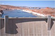
. The Colorado River then flows into Lake Powell
Lake Powell
Lake Powell is a huge reservoir on the Colorado River, straddling the border between Utah and Arizona . It is the second largest man-made reservoir in the United States behind Lake Mead, storing of water when full...
, formed by the Glen Canyon Dam
Glen Canyon Dam
Glen Canyon Dam is a concrete arch dam on the Colorado River in northern Arizona in the United States, just north of Page. The dam was built to provide hydroelectricity and flow regulation from the upper Colorado River Basin to the lower. Its reservoir is called Lake Powell, and is the second...
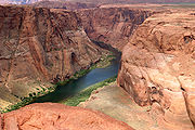
, where the San Juan River joins. Below the dam, water released from the bottom of Lake Powell makes the river clear, clean, and cold. Just south of the town of Page
Page, Arizona
Page is a city in Coconino County, Arizona, United States, near the Glen Canyon Dam and Lake Powell. According to 2005 Census Bureau estimates, the population of the city is 6,794.-Geography:Page is located at ....
, Arizona
Arizona
Arizona ; is a state located in the southwestern region of the United States. It is also part of the western United States and the mountain west. The capital and largest city is Phoenix...
, the river forms the dramatic Horseshoe Bend
Horseshoe Bend, Arizona
Horseshoe Bend is the name for a horseshoe-shaped meander of the Colorado River located near the town of Page, Arizona, in the United States. The bend is locally known as "King Bend." It is located five miles downstream from the Glen Canyon Dam and Lake Powell within Glen Canyon National...
, then at Lees Ferry is joined by another tributary, the warm, shallow, muddy Paria River
Paria River
The Paria River is a tributary of the Colorado River, approximately long, in southern Utah and northern Arizona in the United States. It drains a rugged and arid region northwest of the Colorado, flowing through roadless slot canyons along part of its course....
, and begins its course through Marble Canyon
Marble Canyon
Marble Canyon is the section of the Colorado River canyon in northern Arizona from Lee's Ferry to the confluence with the Little Colorado River, which marks the beginning of the Grand Canyon....
. Here, the Colorado River ranges from 175 to 700 ft (53.3 to 213.4 m) in width and 9 to 130 ft (2.7 to 39.6 m) in depth.
At the southern end of Marble Canyon
Marble Canyon
Marble Canyon is the section of the Colorado River canyon in northern Arizona from Lee's Ferry to the confluence with the Little Colorado River, which marks the beginning of the Grand Canyon....
, the river is joined by another tributary, the Little Colorado River
Little Colorado River
The Little Colorado River is a river in the U.S. state of Arizona, providing the principal drainage from the Painted Desert region. Together with its major tributary, the Puerco River, it drains an area of about in eastern Arizona and western New Mexico...
, and the river then turns abruptly west directly across the folds and fault line of the plateau, through Grand Canyon
Grand Canyon
The Grand Canyon is a steep-sided canyon carved by the Colorado River in the United States in the state of Arizona. It is largely contained within the Grand Canyon National Park, the 15th national park in the United States...
and Grand Canyon National Park
Grand Canyon National Park
Grand Canyon National Park is the United States' 15th oldest national park and is located in Arizona. Within the park lies the Grand Canyon, a gorge of the Colorado River, considered to be one of the Wonders of the World. The park covers of unincorporated area in Coconino and Mohave counties.Most...
, which is 349 km long (217 miles) and from 6 to 30 km (4 to 20 miles) between the upper cliffs. The walls, 4000 to 6000 ft (1,219.2 to 1,828.8 m) high, drop in successive escarpments of 500 to 1600 ft (152.4 to 487.7 m), banded in splendid colors toward the narrow gorge of the present river.
Below the confluence of the Virgin River
Virgin River
The Virgin River is a tributary of the Colorado River in the U.S. states of Utah, Nevada, and Arizona. The river is about long. It was designated Utah's first wild and scenic river in 2009, during the centennial celebration of Zion National Park.-Course:...
in Nevada
Nevada
Nevada is a state in the western, mountain west, and southwestern regions of the United States. With an area of and a population of about 2.7 million, it is the 7th-largest and 35th-most populous state. Over two-thirds of Nevada's people live in the Las Vegas metropolitan area, which contains its...
, the Colorado River abruptly turns southward. Hoover Dam
Hoover Dam
Hoover Dam, once known as Boulder Dam, is a concrete arch-gravity dam in the Black Canyon of the Colorado River, on the border between the US states of Arizona and Nevada. It was constructed between 1931 and 1936 during the Great Depression and was dedicated on September 30, 1935, by President...
, built during the Great Depression, forms Lake Mead
Lake Mead
Lake Mead is the largest reservoir in the United States. It is located on the Colorado River about southeast of Las Vegas, Nevada, in the states of Nevada and Arizona. Formed by water impounded by the Hoover Dam, it extends behind the dam, holding approximately of water.-History:The lake was...
, a popular recreation site as well as the supplier of most of the water for the Las Vegas metropolitan area
Las Vegas metropolitan area
The Las Vegas Valley is the heart of the Las Vegas-Paradise, NV MSA also known as the Las Vegas–Paradise–Henderson MSA which includes all of Clark County, Nevada, and is a metropolitan area in the southern part of the U.S. state of Nevada. The Valley is defined by the Las Vegas Valley landform, a ...
. From Hoover Dam, the river flows south and forms part of the boundary between Arizona
Arizona
Arizona ; is a state located in the southwestern region of the United States. It is also part of the western United States and the mountain west. The capital and largest city is Phoenix...
and Nevada
Nevada
Nevada is a state in the western, mountain west, and southwestern regions of the United States. With an area of and a population of about 2.7 million, it is the 7th-largest and 35th-most populous state. Over two-thirds of Nevada's people live in the Las Vegas metropolitan area, which contains its...
and between Arizona and California
California
California is a state located on the West Coast of the United States. It is by far the most populous U.S. state, and the third-largest by land area...
. Along the California-Arizona reach of the river, four additional dams are operated to divert water for municipal supplies and agricultural irrigation, and for recreational uses. Lake Mohave
Lake Mohave
Lake Mohave is a reservoir formed by Davis Dam on the Colorado River, which defines the border between Nevada and Arizona in the United States. The lake lies at an elevation of near Laughlin, Nevada, Searchlight, Nevada, Cottonwood Cove, Nevada, and Bullhead City, Arizona, about downstream from...
, formed by Davis Dam
Davis Dam
Davis Dam is a dam on the Colorado River about downstream from Hoover Dam. It stretches across the border between Arizona and Nevada. Originally called Bullhead Dam, Davis Dam was renamed after Arthur Powell Davis, who was the director of the U.S. Bureau of Reclamation from 1914 to 1932...
, lies in the southern portion of the Lake Mead
Lake Mead
Lake Mead is the largest reservoir in the United States. It is located on the Colorado River about southeast of Las Vegas, Nevada, in the states of Nevada and Arizona. Formed by water impounded by the Hoover Dam, it extends behind the dam, holding approximately of water.-History:The lake was...
National Recreation Area. Lake Havasu
Lake Havasu
Lake Havasu is a large reservoir behind Parker Dam on the Colorado River, on the border between California and Arizona. Lake Havasu City sits on the lake's eastern shore. The lake has a capacity of . The concrete arch dam was built by the United States Bureau of Reclamation between 1934 and 1938...
, formed by Parker Dam
Parker Dam
Parker Dam is a concrete arch-gravity dam that crosses the Colorado River downstream of Hoover Dam. Built between 1934 and 1938 by the Bureau of Reclamation, it is high, of which are below the riverbed, making it "the deepest dam in the world". The dam's primary functions are to create a...
, provides recreation as well as the home of the retired U.K. London Bridge
London Bridge
London Bridge is a bridge over the River Thames, connecting the City of London and Southwark, in central London. Situated between Cannon Street Railway Bridge and Tower Bridge, it forms the western end of the Pool of London...
, now the New London Bridge
London Bridge (Lake Havasu City)
London Bridge is a bridge in Lake Havasu City, Arizona, United States, that is the reconstruction of the 1831 London Bridge that spanned the River Thames in London, England until it was dismantled in 1967. The Arizona bridge is a reinforced concrete structure clad in the original masonry of the...
. The two remaining dams supply irrigation water: Palo Verde Diversion Dam and Imperial Dam
Imperial Dam
The Imperial Diversion Dam is a concrete slab and buttress, ogee weir structure across the California/Arizona border, northeast of Yuma. Completed in the 1938, the dam retains the waters of the Colorado River into the Imperial Reservoir before desilting and diversion into the All-American Canal,...
. Here, the Colorado River ranges in width from 700 to 2500 ft (213.4 to 762 m) and from 8 to 100 ft (2.4 to 30.5 m) in depth.
Final course
Below the Black CanyonBlack Canyon of the Colorado
The Black Canyon of the Colorado is the canyon on the Colorado River where Hoover Dam was built. The canyon is located on the Colorado River at the state line between Nevada and Arizona. The western wall of the gorge is in the El Dorado Mountains, and the eastern wall is in the Black Mountains of...
the river lessens in gradient and in its lower course flows through the Colorado Desert
Colorado Desert
California's Colorado Desert is a part of the larger Sonoran Desert, which extends across southwest North America. The Colorado Desert region encompasses approximately , reaching from the Mexican border in the south to the higher-elevation Mojave Desert in the north and from the Colorado River in...
in a broad sedimentary valley's distinct estuarine plain upriver from Yuma
Yuma, Arizona
Yuma is a city in and the county seat of Yuma County, Arizona, United States. It is located in the southwestern corner of the state, and the population of the city was 77,515 at the 2000 census, with a 2008 Census Bureau estimated population of 90,041....
, where it is joined by the Gila River
Gila River
The Gila River is a tributary of the Colorado River, 650 miles long, in the southwestern states of New Mexico and Arizona.-Description:...
. The channel through much of this region is bedded in a dike-like embankment lying above the floodplain over which the escaping water spills in time of flood. This dike cuts off the flow of the river to the remarkable low area in southern California known as the Salton Sink
Salton Sink
The Salton Sink is a geographic sink in the Coachella and Imperial valleys of southeastern California. It is in the Colorado Desert subregion of the Sonoran Desert ecoregion...
in the Coachella Valley
Coachella Valley
Coachella Valley is a large valley landform in Southern California. The valley extends for approximately 45 miles in Riverside County southeast from the San Bernardino Mountains to the saltwater Salton Sea, the largest lake in California...
, and the Imperial Valley. The Salton Sink and its Salton Sea
Salton Sea
The Salton Sea is a shallow, saline, endorheic rift lake located directly on the San Andreas Fault, predominantly in California's Imperial Valley. The lake occupies the lowest elevations of the Salton Sink in the Colorado Desert of Imperial and Riverside counties in Southern California. Like Death...
are located below sea level; therefore, the descent from the river near Yuma is very much greater than the descent from Yuma to the Gulf of California
Gulf of California
The Gulf of California is a body of water that separates the Baja California Peninsula from the Mexican mainland...
.
The lower course of the river—which forms the border between the Mexican state of Sonora
Sonora
Sonora officially Estado Libre y Soberano de Sonora is one of the 31 states which, with the Federal District, comprise the 32 Federal Entities of Mexico. It is divided into 72 municipalities; the capital city is Hermosillo....
on the mainland and the state of Baja California
Baja California
Baja California officially Estado Libre y Soberano de Baja California is one of the 31 states which, with the Federal District, comprise the 32 Federal Entities of Mexico. It is both the northernmost and westernmost state of Mexico. Before becoming a state in 1953, the area was known as the North...
on the Baja California peninsula
Baja California Peninsula
The Baja California peninsula , is a peninsula in northwestern Mexico. Its land mass separates the Pacific Ocean from the Gulf of California. The Peninsula extends from Mexicali, Baja California in the north to Cabo San Lucas, Baja California Sur in the south.The total area of the Baja California...
—is a dry or small stream most of the year due to the river being diverted into the Imperial Valley's irrigation source, the All-American Canal
All-American Canal
The All-American Canal is an long aqueduct, located in southeastern California. It conveys water from the Colorado River into the Imperial Valley and to nine cities. It is the Imperial Valley's only water source, and replaced the Alamo Canal, which was located mostly in Mexico...
. Several miles from its mouth, the Hardy River
Hardy River
The Hardy River is a -long Mexican river formed by residual agricultural waters from the Mexicali Valley and running into the Colorado River.-Wildlife:The Rio Hardy is home to a variety of wildlife, including the mosquitofish and the sailfin molly....
enters, adding a little water to the often dry Colorado before it reaches the Gulf of California.
Prior to the mid 20th century, the Colorado River Delta
Colorado River Delta
The Colorado River Delta is the region where the Colorado River flows into the Gulf of California . The delta is part of a larger geologic region called the Salton Trough. Historically, the interaction of the river’s flow and the ocean’s tide created a dynamic environment, supporting freshwater,...
provided a rich estuarine marshland; while today it is now essentially desiccated, the river is still an important ecological estuary
Estuary
An estuary is a partly enclosed coastal body of water with one or more rivers or streams flowing into it, and with a free connection to the open sea....
resource. The estuary of the Colorado River was subjected to a major tidal bore
Tidal bore
A tidal bore is a tidal phenomenon in which the leading edge of the incoming tide forms a wave of water that travel up a river or narrow bay against the direction of the river or bay's current...
that has almost disappeared with the drastic reduction in the freshwater flow following the irrigation diversions of the Colorado River, and to a lesser extent because of some dredging of the estuary channel. The first historical record of the tidal bore was that of the Croatia
Croatia
Croatia , officially the Republic of Croatia , is a unitary democratic parliamentary republic in Europe at the crossroads of the Mitteleuropa, the Balkans, and the Mediterranean. Its capital and largest city is Zagreb. The country is divided into 20 counties and the city of Zagreb. Croatia covers ...
n missionary in Spanish service Father Ferdinand Konščak
Ferdinand Konšcak
Ferdinand Konščak was a Jesuit missionary, explorer, and cartographer.-Education:...
on 18 July 1746. During spring tide conditions, the tidal bore formed in the estuary about Montague Island
Montague Island (Mexico)
Montague Island, known in Spanish as Isla Montague, is an island at the mouth of the Colorado River in the municipality of Mexicali, Baja California, Mexico, and is part of the Colorado River Delta and part of a broader region called the Salton Trough...
and propagated upstream. It was called locally 'El Burro' or 'burro
Burro
The burro is a small donkey used primarily as a pack animal. In addition, significant numbers of feral burros live in the Southwestern United States, where they are protected by law, and in Mexico...
'. Today the tidal bore is rarely seen although there are still some anecdotal observations.
Discharge
The Colorado River's discharge has been modified by large dams and diversions for irrigation, resulting in a reduction of the river's dischargeDischarge (hydrology)
In hydrology, discharge is the volume rate of water flow, including any suspended solids , dissolved chemical species and/or biologic material , which is transported through a given cross-sectional area...
along its lower course. The diversions are principally responsible for reducing the average flow of the Colorado near its mouth from about 22000 cuft/s between 1903 and 1934 to less than 4000 cuft/s from 1951 to 1980. Annual flow near the river's mouth in 1984 was 17500 cuft/s due to record-breaking precipitation. From 1975 to 2004 the average flow at the US–Mexico border was 2661 cuft/s.
The United States Geological Survey
United States Geological Survey
The United States Geological Survey is a scientific agency of the United States government. The scientists of the USGS study the landscape of the United States, its natural resources, and the natural hazards that threaten it. The organization has four major science disciplines, concerning biology,...
(USGS) operates a number of stream gauge
Stream gauge
A stream gauge, stream gage or gauging station is a location used by hydrologists or environmental scientists to monitor and test terrestrial bodies of water. Hydrometric measurements of water surface elevation and/or volumetric discharge are generally taken and observations of biota may also be...
s along the Colorado River. A gauge on its middle course, at Lee's Ferry
Lee's Ferry
Lee's Ferry is a site on the Colorado River in Coconino County, Arizona, United States, about 7.5 miles southwest of the town of Page, Arizona and the Glen Canyon Dam, and about 9 mi south of the Utah-Arizona border. It is the former location of a ferry established by John D. Lee, a Mormon...
, 25.6 kilometres (15.9 mi) below Glen Canyon Dam
Glen Canyon Dam
Glen Canyon Dam is a concrete arch dam on the Colorado River in northern Arizona in the United States, just north of Page. The dam was built to provide hydroelectricity and flow regulation from the upper Colorado River Basin to the lower. Its reservoir is called Lake Powell, and is the second...
, recorded an average discharge
Discharge (hydrology)
In hydrology, discharge is the volume rate of water flow, including any suspended solids , dissolved chemical species and/or biologic material , which is transported through a given cross-sectional area...
of 17850 cuft/s between 1895 and 2009. The maximum flow recorded at this station was 220000 cuft/s on June 18, 1921. The minimum flow was 700 cuft/s, January 23–24, 1963, resulting from the initial closure of Glen Canyon Dam. The mean annual discharge recorded by downriver gauges are all lower than at the Lee's Ferry gauge, and includes 13860 cuft/s below Hoover Dam
Hoover Dam
Hoover Dam, once known as Boulder Dam, is a concrete arch-gravity dam in the Black Canyon of the Colorado River, on the border between the US states of Arizona and Nevada. It was constructed between 1931 and 1936 during the Great Depression and was dedicated on September 30, 1935, by President...
, 14190 cuft/s below Davis Dam
Davis Dam
Davis Dam is a dam on the Colorado River about downstream from Hoover Dam. It stretches across the border between Arizona and Nevada. Originally called Bullhead Dam, Davis Dam was renamed after Arthur Powell Davis, who was the director of the U.S. Bureau of Reclamation from 1914 to 1932...
, 12040 cuft/s below Parker Dam
Parker Dam
Parker Dam is a concrete arch-gravity dam that crosses the Colorado River downstream of Hoover Dam. Built between 1934 and 1938 by the Bureau of Reclamation, it is high, of which are below the riverbed, making it "the deepest dam in the world". The dam's primary functions are to create a...
, 1724 cuft/s below the Laguna Diversion Dam
Laguna Diversion Dam
The Laguna Diversion Dam is an rock-fill diversion dam on the Colorado River. It is located 13 miles northeast of Winterhaven, CA–Yuma, AZ on Imperial County route S24...
, and 1988 cuft/s, for 2008–2009, at the Northerly International Boundary (NIB) with Mexico, 1.8 kilometres (1.1 mi) above Morelos Dam
Morelos Dam
After a 1944 United States Mexico Treaty the Morelos Dam was built in 1950 across the Colorado River. It is located about below the junction of the California border and the Colorado River between the town of Los Algodones, Baja California, in northwestern Mexico and Yuma County, Arizona in the...
. This NIB gauge has operated since 1950 and is, via the International Boundary and Water Commission
International Boundary and Water Commission
The International Boundary and Water Commission is an international body created in 1889 by the United States and Mexico to administer the many boundary and water-rights treaties and agreements between the two nations....
, the accounting point for the 1944 International Treaty detailing water delivery to Mexico.
The last stream gauge is at the Southerly International Boundary (SIB), where the river leaves the United States altogether. Although the river flows about 123 kilometres (76.4 mi) from the SIB to its mouth, no discharge data has been collected since 1983. The amount of water that reaches the mouth of the Colorado River is not known. It is often estimated to be similar to that recorded at the SIB even though this is probably inaccurate. Accounts of flow below the SIB range from zero to a level equal to that recorded at the SIB. The average annual discharge at the SIB from 1975 to 2004 was 1928000 acre.ft. During that period's 18 "non-surplus" years the flow at the SIB was only 865000 acre.ft per year. There has been no measurable flow at all at the SIB for extended periods during many years. In 1996 no flow was recorded on any day of the entire year. Nonetheless, a small amount of water flows into the Colorado River below the SIB, mostly from irrigation returns
Return flow
Return flow is surface and subsurface water that leaves the field following application of irrigation water. While irrigation return flows are a point source, they are expressly exempted from permit requirements under the Clean Water Act ....
, the Hardy River
Hardy River
The Hardy River is a -long Mexican river formed by residual agricultural waters from the Mexicali Valley and running into the Colorado River.-Wildlife:The Rio Hardy is home to a variety of wildlife, including the mosquitofish and the sailfin molly....
, and effluent
Effluent
Effluent is an outflowing of water or gas from a natural body of water, or from a human-made structure.Effluent is defined by the United States Environmental Protection Agency as “wastewater - treated or untreated - that flows out of a treatment plant, sewer, or industrial outfall. Generally refers...
from the cities of San Luis Río Colorado
San Luis Río Colorado
San Luis Río Colorado is a city and its surrounding municipality lying in the northwestern corner of the state of Sonora, Mexico.- Location :...
and Mexicali
Mexicali
Mexicali is the capital of the State of Baja California, seat of the Municipality of Mexicali, and 2nd largest city in Baja California. The City of Mexicali has a population of 689,775, according to the 2010 census, while the population of the entire metropolitan area reaches 936,826.The city...
.
Geology
About 100 million years ago, during the CretaceousCretaceous
The Cretaceous , derived from the Latin "creta" , usually abbreviated K for its German translation Kreide , is a geologic period and system from circa to million years ago. In the geologic timescale, the Cretaceous follows the Jurassic period and is followed by the Paleogene period of the...
period, the southwestern United States was still part of the Western Interior Seaway
Western Interior Seaway
The Western Interior Seaway, also called the Cretaceous Seaway, the Niobraran Sea, and the North American Inland Sea, was a huge inland sea that split the continent of North America into two halves, Laramidia and Appalachia, during most of the mid- and late-Cretaceous Period...
and the Pacific Ocean
Pacific Ocean
The Pacific Ocean is the largest of the Earth's oceanic divisions. It extends from the Arctic in the north to the Southern Ocean in the south, bounded by Asia and Australia in the west, and the Americas in the east.At 165.2 million square kilometres in area, this largest division of the World...
. It was only when the Farallon Plate
Farallon Plate
The Farallon Plate was an ancient oceanic plate, which began subducting under the west coast of the North American Plate— then located in modern Utah— as Pangaea broke apart during the Jurassic Period...
was subducted under the North American Plate
North American Plate
The North American Plate is a tectonic plate covering most of North America, Greenland, Cuba, Bahamas, and parts of Siberia, Japan and Iceland. It extends eastward to the Mid-Atlantic Ridge and westward to the Chersky Range in eastern Siberia. The plate includes both continental and oceanic crust...
in what is now known as the Laramide orogeny
Laramide orogeny
The Laramide orogeny was a period of mountain building in western North America, which started in the Late Cretaceous, 70 to 80 million years ago, and ended 35 to 55 million years ago. The exact duration and ages of beginning and end of the orogeny are in dispute, as is the cause. The Laramide...
about 75 million years ago, did the Rocky Mountains thrust out of the flat seascape, and thus the Colorado River was born. The Upper Colorado, Gunnison
Gunnison River
The Gunnison River is a tributary of the Colorado River, long, in the Southwest state of Colorado. It is the fifth largest tributary of the Colorado River, with a mean flow of 4320 ft³/s .-Description:...
, and San Juan Rivers all formed in this way. However, instead of cutting southwest across the Colorado Plateau to the Gulf of California, the Colorado was instead diverted northeast into present-day Wyoming by the Colorado Plateau to join the headwaters of the North Platte River
North Platte River
The North Platte River is a major tributary of the Platte River and is approximately long counting its many curves, It travels about distance. Its course lies in the U.S...
. Later, with the uplift of mountain ranges in northern Utah and southern Wyoming, the Colorado was instead diverted eastwards, into the Great Basin
Great Basin
The Great Basin is the largest area of contiguous endorheic watersheds in North America and is noted for its arid conditions and Basin and Range topography that varies from the North American low point at Badwater Basin to the highest point of the contiguous United States, less than away at the...
, where in flood, it would sometimes reach the Snake River
Snake River
The Snake is a major river of the greater Pacific Northwest in the United States. At long, it is the largest tributary of the Columbia River, the largest North American river that empties into the Pacific Ocean...
.
During the Miocene
Miocene
The Miocene is a geological epoch of the Neogene Period and extends from about . The Miocene was named by Sir Charles Lyell. Its name comes from the Greek words and and means "less recent" because it has 18% fewer modern sea invertebrates than the Pliocene. The Miocene follows the Oligocene...
, the lower course of the river began to form, completely independent of the upper Colorado. It began as the entrenched gorge of the Kanab Creek
Kanab Creek
Kanab Creek is one of the many tributaries of the Grand Canyon. It begins in Kane County, Utah, just south of the watershed to the Great Basin and flows south to the Colorado River. It passes Kanab, Utah, crossing the border to Arizona near Fredonia...
, a northern tributary of the Colorado in the present-day Grand Canyon. The waters from the Colorado Plateau flowed into the Kanab, joining other tributaries and flowing westwards across present-day Central California
Central California
Central California, sometimes referenced as Mid-State, is an area of California south of the San Francisco Bay Area and north of Southern California...
, flowing into the Pacific at Monterey Bay
Monterey Bay
Monterey Bay is a bay of the Pacific Ocean, along the central coast of California. The bay is south of San Francisco and San Jose, between the cities of Santa Cruz and Monterey....
where it is believed to have been responsible for creating the Monterey submarine canyon
Monterey Canyon
Monterey Canyon, or Monterey Submarine Canyon, is a submarine canyon in Monterey Bay, California. It is the subject of ongoing study by the scientists at the Monterey Bay Aquarium Research Institute, the Moss Landing Marine Laboratories, and other oceanographic institutions.Monterey Canyon begins...
and its associated alluvial fan
Alluvial fan
An alluvial fan is a fan-shaped deposit formed where a fast flowing stream flattens, slows, and spreads typically at the exit of a canyon onto a flatter plain. A convergence of neighboring alluvial fans into a single apron of deposits against a slope is called a bajada, or compound alluvial...
. Over millions of years, this entirely independent river slowly eroded what would become the western half of the Grand Canyon. Meanwhile, the Little Colorado River
Little Colorado River
The Little Colorado River is a river in the U.S. state of Arizona, providing the principal drainage from the Painted Desert region. Together with its major tributary, the Puerco River, it drains an area of about in eastern Arizona and western New Mexico...
's drainage path formed in the Painted Desert
Painted Desert
Painted Desert may refer to:In places:* Painted Desert, Arizona, an area of badlands in the southwestern United States* Painted Desert , a mountainous area in south-central Australia...
, emptying into a large endorheic basin in northeastern Arizona, Hopi Lake, where it usually terminated excepting during floods. The upper Colorado River changed course between the Great Basin and the Colorado Plateau several times, cutting Marble Canyon
Marble Canyon
Marble Canyon is the section of the Colorado River canyon in northern Arizona from Lee's Ferry to the confluence with the Little Colorado River, which marks the beginning of the Grand Canyon....
and Glen Canyon
Glen Canyon
Glen Canyon is a canyon that is located in southeastern and south central Utah and northwestern Arizona within the Vermilion Cliffs area. It was carved by the Colorado River....
in a northwesterly direction as it emptied back into the Great Basin, in the opposite direction of which the water now flows. Later, tectonic activity helped to tilt the land such that the flow in Marble and Glen Canyons reversed to the southwest. This explains why many of the present-day tributaries in this section, such as the Little Colorado, flow into the river at obtuse angles i.e. opposite to the river's present flow direction.
The most widely believed theory is that the Colorado had been continually flowing across the Plateau for about 65 million years, slowly and steadily eroding the Grand Canyon. However, an alternative theory is that roughly 5.4 million years ago, the Colorado's flow again shifted into Hopi Lake. Hopi Lake overflowed across the Colorado Plateau in a massive flood, eroding the Grand Canyon in a much shorter time period than previously believed. Either way, uplift of the high mountain ranges in California, such as the Sierra Nevada, Tehachapis
Tehachapi Mountains
The Tehachapi Mountains , regionally also called The Tehachapis, are a mountain range in the Transverse Ranges system of California in the Western United States...
, and Transverse Ranges
Transverse Ranges
The Transverse Ranges are a group of mountain ranges of southern California, in the Pacific Coast Ranges physiographic region that runs along the Pacific coast from Alaska to Mexico in North America. The Transverse Ranges begin at the southern end of the California Coast Ranges and lie between...
then blocked the path of the Colorado and diverted it southwards into the Gulf of California, where it began to build a vast delta
River delta
A delta is a landform that is formed at the mouth of a river where that river flows into an ocean, sea, estuary, lake, reservoir, flat arid area, or another river. Deltas are formed from the deposition of the sediment carried by the river as the flow leaves the mouth of the river...
. This delta eventually walled off the northern part of the Gulf of California from the rest of the body of water, creating the Salton Sink
Salton Sink
The Salton Sink is a geographic sink in the Coachella and Imperial valleys of southeastern California. It is in the Colorado Desert subregion of the Sonoran Desert ecoregion...
, which dried up except when the Colorado changed course to empty into the basin, as it did in 1904 creating the Salton Sea
Salton Sea
The Salton Sea is a shallow, saline, endorheic rift lake located directly on the San Andreas Fault, predominantly in California's Imperial Valley. The lake occupies the lowest elevations of the Salton Sink in the Colorado Desert of Imperial and Riverside counties in Southern California. Like Death...
.
First inhabitants
Several groups of ancient nomadic people, descended from Uto-Aztecan speakers, sparsely populated the Colorado Plateau thousands of years ago. In about 6,000 B.C., the Hisatsinom, predecessor of the Puebloan peoples, emerged near the Four Corners region around the San Juan River, while about 500 B.C., people of the Fremont cultureFremont culture
The Fremont culture or Fremont people is a pre-Columbian archaeological culture which received its name from the Fremont River in the U.S. state of Utah where the first Fremont sites were discovered. The Fremont River itself is named for John Charles Frémont, an American explorer. It inhabited...
began to populate the area around the Green River and the eastern part of the Great Basin
Great Basin
The Great Basin is the largest area of contiguous endorheic watersheds in North America and is noted for its arid conditions and Basin and Range topography that varies from the North American low point at Badwater Basin to the highest point of the contiguous United States, less than away at the...
. It was not until about 700 A.D. that the ancestral Puebloans began to cultivate crops for food, and the famous cliff dwellings for which they are best known did not come into being until past 1000 A.D.
Native American groups such as the Anasazi, Navajo
Navajo people
The Navajo of the Southwestern United States are the largest single federally recognized tribe of the United States of America. The Navajo Nation has 300,048 enrolled tribal members. The Navajo Nation constitutes an independent governmental body which manages the Navajo Indian reservation in the...
, Pueblo and Hohokam
Hohokam
Hohokam is one of the four major prehistoric archaeological Oasisamerica traditions of what is now the American Southwest. Many local residents put the accent on the first syllable . Variant spellings in current, official usage include Hobokam, Huhugam and Huhukam...
Indians later lived on the arid lands of the Colorado Plateau, using water from the Colorado and its tributaries for irrigation
Irrigation
Irrigation may be defined as the science of artificial application of water to the land or soil. It is used to assist in the growing of agricultural crops, maintenance of landscapes, and revegetation of disturbed soils in dry areas and during periods of inadequate rainfall...
. These two native groups formed large agriculture
Agriculture
Agriculture is the cultivation of animals, plants, fungi and other life forms for food, fiber, and other products used to sustain life. Agriculture was the key implement in the rise of sedentary human civilization, whereby farming of domesticated species created food surpluses that nurtured the...
-based societies which each only lasted for a few hundred years, starting from around 200 B.C. The Anasazi inhabited the northern part of the Plateau and the foothills of the Rockies, in areas such as Chaco Canyon near the San Juan and Green
Green River (Utah)
The Green River, located in the western United States, is the chief tributary of the Colorado River. The watershed of the river, known as the Green River Basin, covers parts of Wyoming, Utah, and Colorado. The Green River is long, beginning in the Wind River Mountains of Wyoming and flowing...
Rivers, while the Hohokam lived in present-day central Arizona in the Gila River
Gila River
The Gila River is a tributary of the Colorado River, 650 miles long, in the southwestern states of New Mexico and Arizona.-Description:...
valley around the confluence with the Salt River
Salt River (Arizona)
The Salt River is a stream in the U.S. state of Arizona. It is the largest tributary of the Gila River. The river is about long. Its drainage basin is about large. The longest of the Salt River's many tributaries is the Verde River...
. Both the Anasazi and Hohokam utilized extensive systems of canals to water their farmland, with over 352 kilometres (218.7 mi) utilized by the Hohokam alone.
Native civilization reached its peak from 600 to 900 A.D. in the Colorado watershed, but began a general decline afterwards. Around the 13th century and 14th century, near the height of a second peak, the Anasazi and Hohokam cultures suddenly "disappeared" from the lands around the Colorado River. Their demise is believed to be linked to the overuse of water for irrigation combined with a severe half-century drought
Drought
A drought is an extended period of months or years when a region notes a deficiency in its water supply. Generally, this occurs when a region receives consistently below average precipitation. It can have a substantial impact on the ecosystem and agriculture of the affected region...
. Intensive irrigation raised the water table
Water table
The water table is the level at which the submarine pressure is far from atmospheric pressure. It may be conveniently visualized as the 'surface' of the subsurface materials that are saturated with groundwater in a given vicinity. However, saturated conditions may extend above the water table as...
while increasing the salinity
Salinity
Salinity is the saltiness or dissolved salt content of a body of water. It is a general term used to describe the levels of different salts such as sodium chloride, magnesium and calcium sulfates, and bicarbonates...
of the soils used for farming, eventually making them unsuitable. Flash flood
Flash flood
A flash flood is a rapid flooding of geomorphic low-lying areas—washes, rivers, dry lakes and basins. It may be caused by heavy rain associated with a storm, hurricane, or tropical storm or meltwater from ice or snow flowing over ice sheets or snowfields...
s during the 12th century and 13th century were probably responsible for the demise of the Chaco culture, and the Navajo and Puebloan people who lived in the high desert in the Four Corners region near present-day Lake Powell
Lake Powell
Lake Powell is a huge reservoir on the Colorado River, straddling the border between Utah and Arizona . It is the second largest man-made reservoir in the United States behind Lake Mead, storing of water when full...
declined as well.
It is believed that during the severe droughts of the three centuries surrounding the 13th century, many of the peoples that once inhabited the upper regions of the Colorado watershed migrated to the Rio Grande
Rio Grande
The Rio Grande is a river that flows from southwestern Colorado in the United States to the Gulf of Mexico. Along the way it forms part of the Mexico – United States border. Its length varies as its course changes...
valley and the Painted Desert
Painted Desert
Painted Desert may refer to:In places:* Painted Desert, Arizona, an area of badlands in the southwestern United States* Painted Desert , a mountainous area in south-central Australia...
in the Little Colorado River
Little Colorado River
The Little Colorado River is a river in the U.S. state of Arizona, providing the principal drainage from the Painted Desert region. Together with its major tributary, the Puerco River, it drains an area of about in eastern Arizona and western New Mexico...
region. Many of the people in the Hopi
Hopi
The Hopi are a federally recognized tribe of indigenous Native American people, who primarily live on the Hopi Reservation in northeastern Arizona. The Hopi area according to the 2000 census has a population of 6,946 people. Their Hopi language is one of the 30 of the Uto-Aztecan language...
and Zuni tribes of the Sonoran Desert
Sonoran Desert
The Sonoran Desert is a North American desert which straddles part of the United States-Mexico border and covers large parts of the U.S. states of Arizona and California and the northwest Mexican states of Sonora, Baja California, and Baja California Sur. It is one of the largest and hottest...
, as well as the Acoma
Acoma Pueblo
Acoma Pueblo is a Native American pueblo approximately 60 miles west of Albuquerque, New Mexico in the United States. Three reservations make up Acoma Pueblo: Sky City , Acomita, and McCartys. The Acoma Pueblo tribe is a federally recognized tribal entity...
and Laguna
Laguna Pueblo
Laguna is a Native American tribe of the Pueblo people in west-central New Mexico, USA. The name, Laguna, is Spanish and derives from the lake located on their reservation. The real Keresan name of the tribe is Kawaik. The population of the tribe exceeds 7,000 , making it the largest Keresan...
people on the Rio Grande, are believed to be descended from the ancient inhabitants of the northeastern Colorado Plateau.
Early records
The existence of the Colorado River was first noted in the records of written history in September, 1539, when Francisco de UlloaFrancisco de Ulloa
Francisco de Ulloa was a Spanish explorer who explored the west coast of present-day Mexico under the commission of Hernán Cortés...
sailed to the head of the Gulf of California
Gulf of California
The Gulf of California is a body of water that separates the Baja California Peninsula from the Mexican mainland...
and rowed a short distance upstream. It was next seen by Hernando de Alarcon
Hernando de Alarcón
Hernando de Alarcón, a Spanish navigator of the 16th century, noted for having led an early expedition to the Baja California peninsula, meant to be coordinated with Francisco Vasquéz de Coronado's overland expedition, and for penetrating the lower Colorado River, perhaps as far as the modern...
who in 1540 led the maritime contingent of Coronado's expedition. The plan was to meet the land based force and resupply them. Alarcon ascended the river about 85 miles to the limit of navigation near present-day Yuma
Yuma, Arizona
Yuma is a city in and the county seat of Yuma County, Arizona, United States. It is located in the southwestern corner of the state, and the population of the city was 77,515 at the 2000 census, with a 2008 Census Bureau estimated population of 90,041....
, Arizona
Arizona
Arizona ; is a state located in the southwestern region of the United States. It is also part of the western United States and the mountain west. The capital and largest city is Phoenix...
. He waited for Coronado, but eventually despaired, cached some supplies and correspondence, left a note on a tree, and departed. Coronado's land forces never reached that location, but Melchior Diaz, on his third expedition, went to see if he could establish contact with Alarcon. By the time he reached the Colorado, however, Alarcon had already left. The Native Americans told him what they knew of Alarcon's presence and that he had left a cache of supplies. Diaz found the note and the supplies. Diaz named the river Rio del Tizon ("River of Embers" or "Firebrand River") based on a practice used by the natives for warming themselves. Meanwhile, Coronado (who at the time was near Zuni, New Mexico) had learned from one of his scouting parties that the natives spoke of a large river to the west. He sent Garcia Lopez de Cardenas
García López de Cárdenas
García López de Cárdenas, , is credited with the first European discovery of the Grand Canyon.- Life :Cárdenas was born in Llerena, Spain, son to Alonso de Cárdenas y doña Elvira de Figueroa and Maria García Osorio. He was the comendador of Caravaca.López de Cárdenas was conquistador attached to...
to lead a contingent of men to find this river. They did find it at what is now known as the Grand Canyon
Grand Canyon
The Grand Canyon is a steep-sided canyon carved by the Colorado River in the United States in the state of Arizona. It is largely contained within the Grand Canyon National Park, the 15th national park in the United States...
, becoming the first people of European background to see it. Their failed attempts at reaching the river led them to conclude that it would not be possible to be supplied via the Gulf of California and the river.
Gila River
The Gila River is a tributary of the Colorado River, 650 miles long, in the southwestern states of New Mexico and Arizona.-Description:...
, and that Rio de buena Guia was his name for the Colorado. In spite of these records, the legend and mapmaking error showing an Island of California
Island of California
The Island of California refers to a long-held European misconception, dating from the 16th century, that California was not part of mainland North America but rather a large island separated from the continent by a strait now known instead as the Gulf of California.One of the most famous...
persisted for more than a century, especially among European cartographers.
Comparisons of 17th, 18th, and early 19th-century maps reveal a parade of names being applied to the Colorado and its tributaries, as well as a variety of courses, as cartographers learned or made up the geography of the region. On a map by Nicholas Sanson (1650) the R. del Tecon and the R. de Coral share a common mouth on the gulf. A number of maps show the Gila River (sometimes just the lower, sometimes the whole) as the Rio Grande de las Apostoles. A 1763 map by Emanuel Bowen
Emanuel Bowen
Emanuel Bowen was an English map engraver, who worked for George II of England and Louis XV of France as a geographerHe published a 'Complete Atlas of Geography,' 1744-7; an 'English Atlas, with a new set of maps,' 1745; a 'Complete Atlas .....
equates the Apostles with the del Coral. A 1720 map by Fer Nicholas labels the main body of the Colorado as Rio del Tison, and a tributary of the Apostles/Gila as Rio Colorade. In 1703 Guillaume de L'Isle showed a Rio de buena esperanza as a major tributary of the Tison, but it is not clear if this tributary corresponds better with the Little Colorado or the San Juan. A map by Herman Moll (1720) charts the Tison and the Gila with separate mouths. Upriver from a tributary of the Tison that would appear to correspond with today's Virgin River, the name for the main channel is given as R. of Good Hope. On other maps Good Hope/Buena Esperanza are transferred to a tributary of the Gila. A map of 1757 gives the name of the main course as Rio Colorado de los Martyres. A map of 1781 by Jonathan Carver charts a major split in the river and labels the eastern branch "Colorado" and the western branch Martyres. A map from 1758 by Didier Robert de Vaugondy
Robert de Vaugondy
Gilles Robert de Vaugondy , also known as Le Sieur or Monsieur Robert, and his son, Didier Robert de Vaugondy , were leading mapmakers in France during the 18th century....
applies the name Colorado to a river that reaches north to the headwaters of the Missouri, best corresponding to today's Green River. When Jedediah Smith first reached the lower Colorado in 1826, he first called it the Seedskeedee, as the headwaters of the Green River were known to the trappers, but also noted that the natives called it the Colorado.
Library of Congress
The Library of Congress is the research library of the United States Congress, de facto national library of the United States, and the oldest federal cultural institution in the United States. Located in three buildings in Washington, D.C., it is the largest library in the world by shelf space and...
, every use of "Colorado" (or Colorade) from 1720 and before is applied to a tributary of what is now the Gila River that seems best to correspond with today's Verde River
Verde River
The Verde River is the north and northwestern watershed of the Salt River–Verde River Watershed that co-join and enter the Gila River at Phoenix, Arizona, located in the U.S. state of Arizona...
. The earliest map in that collection that replaces "Tizon" with "Colorado" is a map from 1743.
The map that resulted from Escalante's expedition in 1776 labels the main channel as the Colorado up to the confluence of the Nabajoo and Zaguananas rivers. The associated information leads one to conclude that the Nabajoo corresponds to the San Juan and the Zaguananas to the Colorado from there to the Dolores River. On this map the Colorado above the Dolores is called the Rafael, and the Green River (named Buenaventura River) is erroneously diverted to the southwest and to what is now called Sevier Lake. Where Escalante's journal records his crossing of the San Rafael, he notes that the Native Americans knew this river as the Colorado. He also notes that the natives said this river had it source in a distant lake, but the lake is not charted on the resulting map. It is evident from a number of maps of the period that people were not aware of the distance between the Colorado's confluence with the Dolores and the western slopes of the Front Range
Front Range
The Front Range is a mountain range of the Southern Rocky Mountains of North America located in the north-central portion of the U.S. State of Colorado and southeastern portion of the U.S. State of Wyoming. It is the first mountain range encountered moving west along the 40th parallel north across...
. On a map from 1847 by John Disturnell, the Rafael is replaced with the Green River, while the upper Colorado (or more correctly, what would be called the Grand River) is not shown at all.
Grand River
"Grand River" is the name applied to the Colorado River from its headwaters in Rocky Mountain National ParkRocky Mountain National Park
Rocky Mountain National Park is a national park located in the north-central region of the U.S. state of Colorado.It features majestic mountain views, a variety of wildlife, varied climates and environments—from wooded forests to mountain tundra—and easy access to back-country trails...
to its confluence with the Green River
Green River (Utah)
The Green River, located in the western United States, is the chief tributary of the Colorado River. The watershed of the river, known as the Green River Basin, covers parts of Wyoming, Utah, and Colorado. The Green River is long, beginning in the Wind River Mountains of Wyoming and flowing...
in Utah
Utah
Utah is a state in the Western United States. It was the 45th state to join the Union, on January 4, 1896. Approximately 80% of Utah's 2,763,885 people live along the Wasatch Front, centering on Salt Lake City. This leaves vast expanses of the state nearly uninhabited, making the population the...
from about 1836 to 1921. This gave rise to several now orphaned names including Grand Lake
Grand Lake (Colorado)
Grand Lake is Colorado's largest and deepest natural lake, one of the headwaters of the Colorado River in Grand County, Colorado. On its shores is located the eponymous town of Grand Lake. The elevation of the lake surface is 8,367 feet . It is formed by the damming of several streams by a...
, Grand Valley
Grand Valley (Colorado)
The Grand Valley is an extended populated valley, approximately 30 miles long and 5 miles wide, located along the Colorado River in Mesa County in western Colorado and Grand County, Utah in the United States. The valley contains the city of Grand Junction, as well as other smaller communities...
, Grand Junction
Grand Junction, Colorado
The City of Grand Junction is the largest city in western Colorado. It is a city with a council–manager government form that is the county seat and the most populous city of Mesa County, Colorado, United States. Grand Junction is situated west-southwest of the Colorado State Capitol in Denver. As...
, Grand County, Colorado
Grand County, Colorado
Grand County is the 21st largest of the 64 counties of the State of Colorado of the United States. The county population was 12,442 at U.S. Census 2000...
, and Grand County, Utah
Grand County, Utah
Grand County is a county located in the U.S. state of Utah. As of 2000 the population was 8,485, and by 2005 had been estimated at 8,743. It was named for the Colorado River, which at the time of statehood was known as the Grand River. Its county seat and largest city is Moab.-Geography:According...
. The earliest appearance of this name on a map could be on the map by Henry Schenck Tanner (1836). The name there replaces the name of Rio Rafael, which appears on many earlier maps. The head of this branch of the Colorado is shown as at about the same latitude as Longs Peak
Longs Peak
Longs Peak is one of the 53 mountains with summits over 14,000 feet in Colorado. It can be prominently seen from Longmont, Colorado, as well as from the rest of the Colorado Front Range. It is named after Major Stephen Long, who explored the area in the 1820s...
in Colorado. There is nothing charted that corresponds to the Green River, nothing that corresponds with the course of the Dolores (even though some earlier maps did show the Dolores with reasonable accuracy), and the headwaters of both the Rio Grande ("Rio del Norte") and especially the Arkansas River are shown to reach to a higher latitude.
A map by David H. Burr (1839) shows the "Colorado River of the West" flowing from the headwaters of the Green River to the Gulf of California, with the "Grand River" as a tributary branching to the east, the third tributary upriver from the Nabajoo (San Juan). The Green River is not separately named. The headwaters of the Grand are depicted as being very close to the headwaters of the Rio Grande (which is labeled "Rio Bravo del Norte") as well as those of the Arkansas River. A textual note on the map indicates that little is known of this area. In 1859, a U.S. Army topographic
Topography
Topography is the study of Earth's surface shape and features or those ofplanets, moons, and asteroids...
expedition led by Captain John Macomb located the confluence of the Green River with the Grand River in what is now Canyonlands National Park
Canyonlands National Park
Canyonlands National Park is a U.S. National Park located in southeastern Utah near the town of Moab and preserves a colorful landscape eroded into countless canyons, mesas and buttes by the Colorado River, the Green River, and their respective tributaries. The park is divided into four districts:...
. The Macomb party designated the confluence as the source of the Colorado River.
In 1921, U.S. Representative Edward T. Taylor
Edward T. Taylor
Edward Thomas Taylor was a U.S. Representative from Colorado.Taylor was born on a farm near Metamora, Illinois. He attended the common schools of Illinois and Kansas, and graduated from the high school at Leavenworth, Kansas, in 1881. Taylor moved to Leadville, Colorado and was principal of...
petitioned the Congressional Committee on Interstate and Foreign Commerce
United States House Committee on Energy and Commerce
The Committee on Energy and Commerce is one of the oldest standing committees of the United States House of Representatives. Established in 1795, it has operated continuously—with various name changes and jurisdictional changes—for more than 200 years...
to rename the Grand River as the Colorado River. On July 25, 1921 the name change was made official in House Joint Resolution 460 of the 66th Congress
66th United States Congress
The Sixty-sixth United States Congress was a meeting of the legislative branch of the United States federal government, comprising the United States Senate and the United States House of Representatives. It met in Washington, DC from March 4, 1919 to March 4, 1921, during the last two years of...
, over the objections of representatives from Wyoming
Wyoming
Wyoming is a state in the mountain region of the Western United States. The western two thirds of the state is covered mostly with the mountain ranges and rangelands in the foothills of the Eastern Rocky Mountains, while the eastern third of the state is high elevation prairie known as the High...
and Utah
Utah
Utah is a state in the Western United States. It was the 45th state to join the Union, on January 4, 1896. Approximately 80% of Utah's 2,763,885 people live along the Wasatch Front, centering on Salt Lake City. This leaves vast expanses of the state nearly uninhabited, making the population the...
and the United States Geological Survey
United States Geological Survey
The United States Geological Survey is a scientific agency of the United States government. The scientists of the USGS study the landscape of the United States, its natural resources, and the natural hazards that threaten it. The organization has four major science disciplines, concerning biology,...
which noted that the drainage basin of the Green River was more than 70% more extensive than that of the Grand River, although the Grand carried a slightly higher volume of water at its confluence with the Green.
Elevation summary
Approximate heights above sea level at several key locations:| Feet | Meters | Location |
| 10184 | 3104 | Colorado Colorado Colorado is a U.S. state that encompasses much of the Rocky Mountains as well as the northeastern portion of the Colorado Plateau and the western edge of the Great Plains... headwaters (Rocky Mountains Rocky Mountains The Rocky Mountains are a major mountain range in western North America. The Rocky Mountains stretch more than from the northernmost part of British Columbia, in western Canada, to New Mexico, in the southwestern United States... ) |
| 6100 | 1850 | midway to Colorado Colorado Colorado is a U.S. state that encompasses much of the Rocky Mountains as well as the northeastern portion of the Colorado Plateau and the western edge of the Great Plains... -Utah Utah Utah is a state in the Western United States. It was the 45th state to join the Union, on January 4, 1896. Approximately 80% of Utah's 2,763,885 people live along the Wasatch Front, centering on Salt Lake City. This leaves vast expanses of the state nearly uninhabited, making the population the... border |
| 4300 | 1300 | Colorado Colorado Colorado is a U.S. state that encompasses much of the Rocky Mountains as well as the northeastern portion of the Colorado Plateau and the western edge of the Great Plains... -Utah Utah Utah is a state in the Western United States. It was the 45th state to join the Union, on January 4, 1896. Approximately 80% of Utah's 2,763,885 people live along the Wasatch Front, centering on Salt Lake City. This leaves vast expanses of the state nearly uninhabited, making the population the... border |
| 3850 | 1170 | midway to Utah Utah Utah is a state in the Western United States. It was the 45th state to join the Union, on January 4, 1896. Approximately 80% of Utah's 2,763,885 people live along the Wasatch Front, centering on Salt Lake City. This leaves vast expanses of the state nearly uninhabited, making the population the... -Arizona Arizona Arizona ; is a state located in the southwestern region of the United States. It is also part of the western United States and the mountain west. The capital and largest city is Phoenix... border |
| 3700 | 1130 | Utah Utah Utah is a state in the Western United States. It was the 45th state to join the Union, on January 4, 1896. Approximately 80% of Utah's 2,763,885 people live along the Wasatch Front, centering on Salt Lake City. This leaves vast expanses of the state nearly uninhabited, making the population the... -Arizona Arizona Arizona ; is a state located in the southwestern region of the United States. It is also part of the western United States and the mountain west. The capital and largest city is Phoenix... border (Wahweap Bay on Lake Powell) |
| 3000 | 900 | midway to Grand Canyon Grand Canyon The Grand Canyon is a steep-sided canyon carved by the Colorado River in the United States in the state of Arizona. It is largely contained within the Grand Canyon National Park, the 15th national park in the United States... (Rider Point near Bitter Springs, Arizona) |
| 2800 | 850 | Grand Canyon Grand Canyon The Grand Canyon is a steep-sided canyon carved by the Colorado River in the United States in the state of Arizona. It is largely contained within the Grand Canyon National Park, the 15th national park in the United States... North Rim |
| 2500 | 760 | Grand Canyon Grand Canyon The Grand Canyon is a steep-sided canyon carved by the Colorado River in the United States in the state of Arizona. It is largely contained within the Grand Canyon National Park, the 15th national park in the United States... South Rim |
| 1200 | 365 | Lake Mead Lake Mead Lake Mead is the largest reservoir in the United States. It is located on the Colorado River about southeast of Las Vegas, Nevada, in the states of Nevada and Arizona. Formed by water impounded by the Hoover Dam, it extends behind the dam, holding approximately of water.-History:The lake was... (above Hoover Dam Hoover Dam Hoover Dam, once known as Boulder Dam, is a concrete arch-gravity dam in the Black Canyon of the Colorado River, on the border between the US states of Arizona and Nevada. It was constructed between 1931 and 1936 during the Great Depression and was dedicated on September 30, 1935, by President... ) |
| 600 | 183 | below Hoover Dam |
| 485 | 150 | California California California is a state located on the West Coast of the United States. It is by far the most populous U.S. state, and the third-largest by land area... -Nevada Nevada Nevada is a state in the western, mountain west, and southwestern regions of the United States. With an area of and a population of about 2.7 million, it is the 7th-largest and 35th-most populous state. Over two-thirds of Nevada's people live in the Las Vegas metropolitan area, which contains its... -Arizona Arizona Arizona ; is a state located in the southwestern region of the United States. It is also part of the western United States and the mountain west. The capital and largest city is Phoenix... border |
| 100 | 30 | California California California is a state located on the West Coast of the United States. It is by far the most populous U.S. state, and the third-largest by land area... -Arizona Arizona Arizona ; is a state located in the southwestern region of the United States. It is also part of the western United States and the mountain west. The capital and largest city is Phoenix... -Mexico Mexico The United Mexican States , commonly known as Mexico , is a federal constitutional republic in North America. It is bordered on the north by the United States; on the south and west by the Pacific Ocean; on the southeast by Guatemala, Belize, and the Caribbean Sea; and on the east by the Gulf of... border |
Note that the significant difference between the present height of the rim of the Grand Canyon
Grand Canyon
The Grand Canyon is a steep-sided canyon carved by the Colorado River in the United States in the state of Arizona. It is largely contained within the Grand Canyon National Park, the 15th national park in the United States...
(about 2440 m; 8000 ft) and the levels at which the river enters/exits it gives rise to the geologic theory that uplift must have begun around the same time the river began flowing through it and eroding it (since rivers do not run uphill, it would have otherwise followed some other path around the uplifted region). Estimates for the beginning of this erosion/uplift process range from 5 to 70 million years ago.
Engineering
Alamo Canal
The Alamo Canal was a long waterway that connected the Colorado River to the head of the Alamo River. The canal was constructed to provide irrigation to the Imperial Valley. A small portion of the canal was located in the United States but the majority of the canal was located in Mexico...
a few miles below Yuma, Arizona
Yuma, Arizona
Yuma is a city in and the county seat of Yuma County, Arizona, United States. It is located in the southwestern corner of the state, and the population of the city was 77,515 at the 2000 census, with a 2008 Census Bureau estimated population of 90,041....
, creating the New River and Alamo River
Alamo River
The Alamo River is a river flowing west and north from the Mexicali Valley across the Imperial Valley . The river drains into the Salton Sea....
, and over two years re-formed the Salton Sea in the Salton Sink
Salton Sink
The Salton Sink is a geographic sink in the Coachella and Imperial valleys of southeastern California. It is in the Colorado Desert subregion of the Sonoran Desert ecoregion...
of California's Coachella Valley
Coachella Valley
Coachella Valley is a large valley landform in Southern California. The valley extends for approximately 45 miles in Riverside County southeast from the San Bernardino Mountains to the saltwater Salton Sea, the largest lake in California...
. The river re-created the Salton Sea
Salton Sea
The Salton Sea is a shallow, saline, endorheic rift lake located directly on the San Andreas Fault, predominantly in California's Imperial Valley. The lake occupies the lowest elevations of the Salton Sink in the Colorado Desert of Imperial and Riverside counties in Southern California. Like Death...
, a great inland sea in the Salton Sink
Salton Sink
The Salton Sink is a geographic sink in the Coachella and Imperial valleys of southeastern California. It is in the Colorado Desert subregion of the Sonoran Desert ecoregion...
, an area that it had frequently inundated before. For example, in 1884 and 1891 the river practically abandoned its regular course through Mexico to the Gulf of California, and flowed into the Salton Sink. However, it was effectively dammed in the early part of 1907 and it returned to its normal course, although from which there was still much leakage to the Salton Sea. In July 1907 the permanent dam was completed, keeping the Colorado's usually normal course from the Black Canyon through the Colorado Desert
Colorado Desert
California's Colorado Desert is a part of the larger Sonoran Desert, which extends across southwest North America. The Colorado Desert region encompasses approximately , reaching from the Mexican border in the south to the higher-elevation Mojave Desert in the north and from the Colorado River in...
basin towards the Gulf of California.
The Colorado River is a major and in some cases life-sustaining source of water for irrigation, drinking, and other uses by people living in the arid American southwest. Allocation of the river's water is governed by the Colorado River Compact
Colorado River Compact
The Colorado River Compact is a 1922 agreement among seven U.S. states in the basin of the Colorado River in the American Southwest governing the allocation of the water rights to the river's water among the parties of the interstate compact...
, a 1922 agreement towards seven U.S. states in the Colorado River basin governing the allocation of the water rights to the river's water among the parties of the interstate compact. More than ten dams have been built along the river, beginning with Shadow Mountain Dam
Shadow Mountain Dam
Shadow Mountain Dam is a zoned earthfill dam on the Colorado River in Grand County, Colorado. Constructed between 1944 and 1946, the Shadow Mountain Dam creates the Shadow Mountain Lake, with a structural height of and a drainage area of . Shadow Mountain Lake is a holding reservoir for water...
in western Colorado and ending with Morelos Dam
Morelos Dam
After a 1944 United States Mexico Treaty the Morelos Dam was built in 1950 across the Colorado River. It is located about below the junction of the California border and the Colorado River between the town of Los Algodones, Baja California, in northwestern Mexico and Yuma County, Arizona in the...
on Arizona's border with Baja California. The first dam on the Colorado, Hoover Dam
Hoover Dam
Hoover Dam, once known as Boulder Dam, is a concrete arch-gravity dam in the Black Canyon of the Colorado River, on the border between the US states of Arizona and Nevada. It was constructed between 1931 and 1936 during the Great Depression and was dedicated on September 30, 1935, by President...
(originally Boulder Dam, and the largest in the world upon completion) was finished in 1936. Its impoundment of the river in the Mojave Desert
Mojave Desert
The Mojave Desert occupies a significant portion of southeastern California and smaller parts of central California, southern Nevada, southwestern Utah and northwestern Arizona, in the United States...
creates Lake Mead
Lake Mead
Lake Mead is the largest reservoir in the United States. It is located on the Colorado River about southeast of Las Vegas, Nevada, in the states of Nevada and Arizona. Formed by water impounded by the Hoover Dam, it extends behind the dam, holding approximately of water.-History:The lake was...
, which provides water for irrigation and the generation of hydroelectric power. Since the completion of dams, the majority of the river in normal hydrologic years is diverted for agricultural and municipal water supply. The Colorado's last drops evaporate in the Sonoran Desert
Sonoran Desert
The Sonoran Desert is a North American desert which straddles part of the United States-Mexico border and covers large parts of the U.S. states of Arizona and California and the northwest Mexican states of Sonora, Baja California, and Baja California Sur. It is one of the largest and hottest...
, more than 60 miles (96.6 km) before the river reaches the Gulf of California.
All-American Canal
The All-American Canal is an long aqueduct, located in southeastern California. It conveys water from the Colorado River into the Imperial Valley and to nine cities. It is the Imperial Valley's only water source, and replaced the Alamo Canal, which was located mostly in Mexico...
is the largest irrigation canal in the world and carries a volume of water from 420 to 850 m³/s (15,000 to 30,000 ft³/s), making it larger in volume than New York
New York
New York is a state in the Northeastern region of the United States. It is the nation's third most populous state. New York is bordered by New Jersey and Pennsylvania to the south, and by Connecticut, Massachusetts and Vermont to the east...
's Hudson River
Hudson River
The Hudson is a river that flows from north to south through eastern New York. The highest official source is at Lake Tear of the Clouds, on the slopes of Mount Marcy in the Adirondack Mountains. The river itself officially begins in Henderson Lake in Newcomb, New York...
. The canal's waters are used to irrigate the fertile Imperial Valley orchards and crops, formerly a Sonoran Desert
Sonoran Desert
The Sonoran Desert is a North American desert which straddles part of the United States-Mexico border and covers large parts of the U.S. states of Arizona and California and the northwest Mexican states of Sonora, Baja California, and Baja California Sur. It is one of the largest and hottest...
ecosystem where several years can pass between measurable rainfalls. Hydrology transport models are used to assess management of the river's flow and water quality.
Several cities such as Phoenix
Phoenix, Arizona
Phoenix is the capital, and largest city, of the U.S. state of Arizona, as well as the sixth most populated city in the United States. Phoenix is home to 1,445,632 people according to the official 2010 U.S. Census Bureau data...
and Tucson
Tucson, Arizona
Tucson is a city in and the county seat of Pima County, Arizona, United States. The city is located 118 miles southeast of Phoenix and 60 miles north of the U.S.-Mexico border. The 2010 United States Census puts the city's population at 520,116 with a metropolitan area population at 1,020,200...
(Central Arizona Project-CAP), Los Angeles
Los Ángeles
Los Ángeles is the capital of the province of Biobío, in the commune of the same name, in Region VIII , in the center-south of Chile. It is located between the Laja and Biobío rivers. The population is 123,445 inhabitants...
and San Bernardino
San Bernardino, California
San Bernardino is a city located in the Riverside-San Bernardino metropolitan area , and serves as the county seat of San Bernardino County, California, United States...
(Colorado River aqueduct
Colorado River Aqueduct
The Colorado River Aqueduct, or CRA, is a water conveyance in Southern California in the United States, operated by the Metropolitan Water District of Southern California . The aqueduct impounds water from the Colorado River at Lake Havasu on the California-Arizona border west across the Mojave...
), Las Vegas, Nevada
Las Vegas, Nevada
Las Vegas is the most populous city in the U.S. state of Nevada and is also the county seat of Clark County, Nevada. Las Vegas is an internationally renowned major resort city for gambling, shopping, and fine dining. The city bills itself as The Entertainment Capital of the World, and is famous...
, and San Diego, California
San Diego, California
San Diego is the eighth-largest city in the United States and second-largest city in California. The city is located on the coast of the Pacific Ocean in Southern California, immediately adjacent to the Mexican border. The birthplace of California, San Diego is known for its mild year-round...
have aqueducts leading all the way back to the Colorado River. The Central Arizona Project (CAP) canal, which was begun in the 1970s and finished in the 1990s, begins at Parker Dam and runs all the way to Phoenix and then Tucson to supplement those cities' water needs.
The lower Colorado is navigable by moderate to large-sized craft. The lower river from Davis Dam to Yuma is navigable by large paddlewheel boats and river barges, but commercial navigation on the river is unimportant because the river is cut off from the sea, making other means of transportation more efficient in the region. Before the railroads arrived, the lower Colorado River from the sea to near present-day Laughlin, Nevada
Laughlin, Nevada
Laughlin is a census-designated place in Clark County, Nevada, United States, and a port located on the Colorado River. Laughlin is south of Las Vegas, located in the far southern tip of Nevada. It is best known for its gaming, entertainment, and water recreation. As of the 2010 census, the...
was an important means of transportation via large steamers. Most of the rest of the river (and reservoirs), excluding the rapids in the canyons, is navigable by small to moderate-sized river craft and power boats.
Fish species
The Colorado River basin is home to fourteen native species of fish. Four are endemicEndemic (ecology)
Endemism is the ecological state of being unique to a defined geographic location, such as an island, nation or other defined zone, or habitat type; organisms that are indigenous to a place are not endemic to it if they are also found elsewhere. For example, all species of lemur are endemic to the...
and endangered
Endangered species
An endangered species is a population of organisms which is at risk of becoming extinct because it is either few in numbers, or threatened by changing environmental or predation parameters...
: Colorado pikeminnow (formerly Colorado squawfish), razorback sucker
Razorback sucker
The razorback sucker, Xyrauchen texanus, is an endangered fresh water sucker of rivers in the Colorado River drainage of western North America.-Description:...
, bonytail chub, and humpback chub. The Upper Colorado River Endangered Fish Recovery Program
Upper Colorado River Endangered Fish Recovery Program
The Upper Colorado River Endangered Fish Recovery Program is a multi-agency partnership to recover endangered fish in the upper Colorado River basin while water development proceeds in compliance with state and federal law .-Overview:Four species of fish native to the Colorado River basin are in...
is a controversial effort by the US Fish and Wildlife Service
United States Fish and Wildlife Service
The United States Fish and Wildlife Service is a federal government agency within the United States Department of the Interior dedicated to the management of fish, wildlife, and natural habitats...
, in conjunction with the Arizona Game and Fish Department
Arizona Game and Fish Department
The Arizona Game and Fish Department is a state agency of Arizona, headquartered in Phoenix. The agency is tasked with conserving, enhancing, and restoring Arizona's diverse wildlife resources and habitats through aggressive protection and management programs...
, the Colorado Division of Wildlife, and the Utah Department of Wildlife to recover these endangered fish.
Brook trout
The brook trout, Salvelinus fontinalis, is a species of fish in the salmon family of order Salmoniformes. In many parts of its range, it is known as the speckled trout or squaretail. A potamodromous population in Lake Superior are known as coaster trout or, simply, as coasters...
, Blue Catfish
Blue catfish
The blue catfish, Ictalurus furcatus, is one of the largest species of North American catfish. Blue catfish are distributed primarily in the Mississippi River drainage including the Missouri, Ohio, Tennessee, and Arkansas rivers...
, Catfish (Channel)
Channel catfish
Channel catfish, Ictalurus punctatus, is North America's most numerous catfish species. It is the official fish of Missouri, Iowa, Nebraska, Kansas, and Tennessee, and is informally referred to as a "channel cat". In the United States they are the most fished catfish species with approximately 8...
, Carp
Carp
Carp are various species of oily freshwater fish of the family Cyprinidae, a very large group of fish native to Europe and Asia. The cypriniformes are traditionally grouped with the Characiformes, Siluriformes and Gymnotiformes to create the superorder Ostariophysi, since these groups have certain...
, Crappie
Crappie
Crappie is a genus of freshwater fish in the sunfish family of order Perciformes. The type species is P. annularis, the white crappie...
, Largemouth Bass
Largemouth bass
The largemouth bass is a species of black bass in the sunfish family native to North America . It is also known as widemouth bass, bigmouth, black bass, bucketmouth, Potter's fish, Florida bass, Florida largemouth, green bass, green trout, linesides, Oswego bass, southern largemouth...
, Rainbow Trout
Rainbow trout
The rainbow trout is a species of salmonid native to tributaries of the Pacific Ocean in Asia and North America. The steelhead is a sea run rainbow trout usually returning to freshwater to spawn after 2 to 3 years at sea. In other words, rainbow trout and steelhead trout are the same species....
, Striped Bass
Striped bass
The striped bass is the state fish of Maryland, Rhode Island, South Carolina, and the state saltwater fish of New York, Virginia, and New Hampshire...
, Sunfish
Centrarchidae
The sunfishes are a family of freshwater ray-finned fish belonging to the order Perciformes. The type genus is Centrarchus . The family's 27 species includes many fishes familiar to North Americans, including the rock bass, largemouth bass, bluegill, pumpkinseed, and crappies...
, Sturgeon
Sturgeon
Sturgeon is the common name used for some 26 species of fish in the family Acipenseridae, including the genera Acipenser, Huso, Scaphirhynchus and Pseudoscaphirhynchus. The term includes over 20 species commonly referred to as sturgeon and several closely related species that have distinct common...
, Colorado Pikeminnow
Colorado pikeminnow
The Colorado pikeminnow Ptychocheilus lucius is the largest cyprinid fish of North America and one of the largest in the world, with reports of individuals up to 6 ft long and weighing over 100 pounds...
, Humpback Chub
Humpback chub
The humpback chub Gila cypha, is a federally protected fish that lived originally in fast waters of the Colorado River system in the United States. This species takes its name from the prominent hump between the head and dorsal fin, which is thought to direct the flow of water over the body and...
, Razorback Sucker
Razorback sucker
The razorback sucker, Xyrauchen texanus, is an endangered fresh water sucker of rivers in the Colorado River drainage of western North America.-Description:...
, Bonytail Chub
Bonytail chub
The bonytail chub or bonytail, Gila elegans, is a cyprinid freshwater fish native to the Colorado River of Arizona, California, Colorado, Nevada and Utah in the southwestern United States...
, Tilapia
Tilapia
Tilapia , is the common name for nearly a hundred species of cichlid fish from the tilapiine cichlid tribe. Tilapia inhabit a variety of fresh water habitats, including shallow streams, ponds, rivers and lakes. Historically, they have been of major importance in artisan fishing in Africa and the...
, Smallmouth bass
Smallmouth bass
The smallmouth bass is a species of freshwater fish in the sunfish family of the order Perciformes. It is the type species of its genus...
Black Bullhead Catfish and Flathead Catfish
Flathead catfish
The flathead catfish , also called the yellow cat, opelousas, and shovelhead cat, are large North American freshwater catfish. This is the only species of the genus Pylodictis...
Environmental issues
The numerous dams on the Colorado have prevented seasonal flooding that would normally clean debris that has accumulated along the river's length. This lack of flooding has also led to erosion of sand bars in the Grand Canyon, which are crucial to wildlife.Moab uranium tailings
Atlas Mineral Corporation operated a uraniumUranium
Uranium is a silvery-white metallic chemical element in the actinide series of the periodic table, with atomic number 92. It is assigned the chemical symbol U. A uranium atom has 92 protons and 92 electrons, of which 6 are valence electrons...
processing mill in the area of Moab, Utah
Moab, Utah
Moab is a city in Grand County, in eastern Utah, in the western United States. The population was 4,779 at the 2000 census. It is the county seat and largest city in Grand County. Moab hosts a large number of tourists every year, mostly visitors to the nearby Arches and Canyonlands National Parks...
, on the north bank of the Colorado River just under 5 km (about 3 miles) from downtown Moab. As a byproduct of uranium processing activities, an estimated 16 million ton pile of chemically and radioactively hazardous tailings
Tailings
Tailings, also called mine dumps, slimes, tails, leach residue, or slickens, are the materials left over after the process of separating the valuable fraction from the uneconomic fraction of an ore...
exists. The pile is located about 700–800 feet (200–250 meters) from the Colorado River. Although no contamination has been detected, the proximity of the material to the watershed has been a concern. The Senate has authorized the U.S. Department of Energy to budget $22.8 million in 2007 to begin the project of moving the uranium tailings farther from the river. The plan is to move the contaminated materials 48 kilometres (29.8 mi) north to a disposal site located at Crescent Junction, Utah. The project is expected to be completed by 2028 with current funding plans, at total estimated cost of US$720 million.
See also
- Alamo CanalAlamo CanalThe Alamo Canal was a long waterway that connected the Colorado River to the head of the Alamo River. The canal was constructed to provide irrigation to the Imperial Valley. A small portion of the canal was located in the United States but the majority of the canal was located in Mexico...
- All-American Canal BridgeAll-American Canal BridgeThe All-American Canal Bridge is a bridge that carries Interstate 8 over the All-American Canal, a canal that supplies water from the Colorado River to the agricultural areas of the Imperial Valley....
- Bridge Canyon DamBridge Canyon DamBridge Canyon Dam is a proposed dam in the lower Grand Canyon of the Colorado River, in northern Arizona in the United States. It would be located near Bridge Canyon Rapids in an extremely rugged and isolated portion of the canyon, roughly downstream of Lee's Ferry and upstream of the current...
- Colorado River CompactColorado River CompactThe Colorado River Compact is a 1922 agreement among seven U.S. states in the basin of the Colorado River in the American Southwest governing the allocation of the water rights to the river's water among the parties of the interstate compact...
- Colorado River DeltaColorado River DeltaThe Colorado River Delta is the region where the Colorado River flows into the Gulf of California . The delta is part of a larger geologic region called the Salton Trough. Historically, the interaction of the river’s flow and the ocean’s tide created a dynamic environment, supporting freshwater,...
- Colorado River Irrigation CompanyColorado River Irrigation CompanyThe Colorado River Irrigation Company was incorporated in Colorado on January 7, 1892 for the purpose of irrigating "lands contiguous to the Colorado River." The company founders claimed to be able to irrigate , with of that being in San Diego County, California and the remainder in Baja...
- Salton SeaSalton SeaThe Salton Sea is a shallow, saline, endorheic rift lake located directly on the San Andreas Fault, predominantly in California's Imperial Valley. The lake occupies the lowest elevations of the Salton Sink in the Colorado Desert of Imperial and Riverside counties in Southern California. Like Death...
- Glen Canyon DamGlen Canyon DamGlen Canyon Dam is a concrete arch dam on the Colorado River in northern Arizona in the United States, just north of Page. The dam was built to provide hydroelectricity and flow regulation from the upper Colorado River Basin to the lower. Its reservoir is called Lake Powell, and is the second...
; Lake PowellLake PowellLake Powell is a huge reservoir on the Colorado River, straddling the border between Utah and Arizona . It is the second largest man-made reservoir in the United States behind Lake Mead, storing of water when full... - Hoover DamHoover DamHoover Dam, once known as Boulder Dam, is a concrete arch-gravity dam in the Black Canyon of the Colorado River, on the border between the US states of Arizona and Nevada. It was constructed between 1931 and 1936 during the Great Depression and was dedicated on September 30, 1935, by President...
; Lake MeadLake MeadLake Mead is the largest reservoir in the United States. It is located on the Colorado River about southeast of Las Vegas, Nevada, in the states of Nevada and Arizona. Formed by water impounded by the Hoover Dam, it extends behind the dam, holding approximately of water.-History:The lake was... - Parker DamParker DamParker Dam is a concrete arch-gravity dam that crosses the Colorado River downstream of Hoover Dam. Built between 1934 and 1938 by the Bureau of Reclamation, it is high, of which are below the riverbed, making it "the deepest dam in the world". The dam's primary functions are to create a...
; Lake HavasuLake HavasuLake Havasu is a large reservoir behind Parker Dam on the Colorado River, on the border between California and Arizona. Lake Havasu City sits on the lake's eastern shore. The lake has a capacity of . The concrete arch dam was built by the United States Bureau of Reclamation between 1934 and 1938... - List of tributaries of the Colorado River
- List of Colorado River rapids and features
- List of flora of the Lower Colorado River Valley
- List of international border rivers
- List of longest main-stem rivers in the United States
- List of longest rivers of Mexico
- Powell Geographic Expedition of 1869Powell Geographic Expedition of 1869The Powell Geographic Expedition was a groundbreaking 19th century U.S. exploratory expedition of the American West, led by John Wesley Powell in 1869, that provided the first-ever thorough investigation of the Green and Colorado rivers, including the first known passage through the Grand Canyon...
External links
- Federal Department of Energy site on uranium mine tailing site.
- State of Utah site on uranium mine tailings.
- Bibliography on Water Resources and International Law Peace Palace Library
- Arizona Boating Locations Facilities Map
- Arizona Fishing Locations Map
- Where to Fish in Arizona Species Information
- Drought Watch Campaign - map of the Colorado River system showing the fill levels of major reservoirs. Last updated July 2004.