
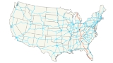
Interstate 75
Encyclopedia
Interstate 75 is a major north–south Interstate Highway in the Great Lakes
and Southeastern
regions of the United States
. It travels from State Road 826
(Palmetto Expressway) and State Road 924
(Gratigny Parkway) in Hialeah, Florida
(northwest of Miami
) to Sault Ste. Marie, Michigan
, at the Ontario
, Canada
, border. Interstate 75 passes through six different states: Florida
, Georgia
, Tennessee
, Kentucky
, Ohio
and Michigan
.
Due to traffic levels on the Interstate, much of the route is six lanes even in rural areas. The longest continuous segment of six-lane (or more) Interstate is along I-75 from the Florida's Turnpike
junction in Wildwood, Florida
to I-24 in the Chattanooga area, using I-475 to bypass Macon, Georgia
.
|FL
|| 470.88 || 757.81
|-
|GA
|| 355.11 || 571.49
|-
|TN
|| 161.86 || 260.49
|-
|KY || 191.78 || 308.64
|-
|OH
|| 211.30 || 340.05
|-
|MI
|| 395.54 || 636.56
|-
|Total || 1786.47 || 2875.04
|}
and an interchange with Interstate 595
and the Sawgrass Expressway
, the interstate leaves the Miami metropolitan area and turns westward to travel through the Everglades
along the tolled Alligator Alley
, which brings the highway to the Gulf Coast and Naples
, where it again heads north. Passing through Bonita Springs
, Fort Myers, and Sarasota, Interstate 75 encounters a series of construction projects that will increase the lane count from two lanes in each direction to three in each direction. The freeway enters the Tampa Bay
metropolitan area before the interchange with Interstate 275
northbound, which handles St. Petersburg-bound traffic. Within the Tampa metro are three more major junctions: One with the Lee Roy Selmon Expressway which carries traffic into downtown Tampa; one with Interstate 4
which carries traffic across the center of the state to the East Coast; and another as Interstate 275 traffic defaults back onto northbound. The freeway proceeds to enter suburban portions of Pasco, Hernando, and Sumter counties on its way to Ocala and Gainesville
. At Lake City, Florida
, the Christopher Columbus Transcontinental Highway, Interstate 10
, intersects with Interstate 75, providing routes toward Jacksonville, Florida
; Tallahassee; Mobile, Alabama
; New Orleans, Louisiana
; and points westward. Afterward, the northmost stetch of Interstate 75 in Florida exits the Sunshine State into southern Georgia
.
near Lake Park
, and it continues northward through the towns of Valdosta, Tifton and Cordele until it reaches the Macon
area, where it intersects with Interstate 16
eastbound towards Savannah
. For northbound traffic wishing to avoid potential congestion in Macon, Interstate 475
provides a relatively straight bypass west of that city and Interstate 75's route. After Macon it passes the small town of Forsyth. The freeway reaches no major junctions again until in the Atlanta metropolitan area. The first metropolitan freeway met is Interstate 675
, then followed by the Atlanta "Perimeter" bypass, Interstate 285
. It crosses inside the Perimeter and heads north several miles towards the Atlanta city center. Interstate 75 is then duplexed with Interstate 85
due north over the Downtown Connector
through the central business district of Atlanta. After the two Interstates split, Interstate 75 makes a beeline northwest, crossing outside the Interstate 285 Perimeter and heading towards the major suburban city of Marietta
. This section of Interstate 75 just north of Interstate 285 has 15 through lanes, making it the widest roadway anywhere in the Interstate Highway System. North of Marietta, the final major junction in the Atlanta metropolitan area is the Interstate 575
spur. Interstate 75 then traverses the hilly northwestern Georgia terrain as it travels towards Chattanooga, Tennessee
.
directly in the Chattanooga metropolitan area, where it intersects with Interstate 24
. Exiting Chattanooga to the northeast, Interstate 75 passes through an area known for dense fog. Twelve people were killed and 42 were injured in a 99 vehicle accident on that stretch of I-75 in heavy fog on December 11, 1990. Interstate 75 does not meet any other highways until it is multiplexed with Interstate 40
and heads eastbound. Together, they enter the outskirts of Knoxville, where Interstate 75 multiplexes itself with a different road, this time Interstate 640
, but only for a short time. When the two meet Interstate 275
, Interstate 75 becomes its own freeway and heads north towards the Kentucky
border. On the journey northward from Knoxville to the Kentucky
border, interstate 75 encounters some of its highest points of elevation through the Cumberland Mountains
and Cumberland Plateau
region, cutting through the uppermost peaks and ridges of the mountains.
region of Kentucky
passing through London
and Richmond
, eventually reaching Lexington
, where it briefly runs coterminously with Interstate 64
before splitting off for Cincinnati, Ohio
. Near Walton, Interstate 71
merges with Interstate 75, making for yet another multiplexed portion of freeway. Interstate 275
, which is the Cincinnati beltway, is then intersected by Interstate 71/75. After passing through Covington
, the freeway crosses the Ohio River
via the lower level of the Brent Spence Bridge
and continues into Cincinnati.
separates from Interstate 75, taking a more easterly routing through the city, while Interstate 75 remains generally northbound throughout the metropolitan area. Interstate 74
westbound, Ohio State Route 562 eastbound, and Ohio State Route 126 all intersect the freeway as it makes its way northward. In Arlington Heights, a suburb of Cincinnati, Interstate 75 sees a carriageway split for a few miles. After another interchange with the Interstate 275
beltway, the freeway continues in the metropolitan area, passes through Middletown
and heads towards Dayton
, where Interstate 675
, Interstate 70
, and U.S. Route 35, have interchanges. The intersection of Interstate 75 with Interstate 70 is known as the Freedom Veterans Crossroads. After exiting the city of Dayton, Interstate 75 makes its way northbound through Ohio, passing through the smaller cities of Wapakoneta
, Lima
, Findlay
and Bowling Green
before finally reaching Toledo
, located on the Michigan
border. Interstate 475
is met first south of the city, and then the cross-country highways of Interstate 80
/Interstate 90
/Ohio Turnpike
. Interstate 475 then meets with 75 again. Interstate 280
is the last major junction in Ohio; the freeway crosses into Michigan soon afterwards.
upon entering Michigan—until about Monroe
, when it heads north eastward and prepares to enter Detroit and its surrounding suburb
s. Yet another I-275
is met as the freeway goes deeper into the Detroit metropolitan area, and no other major junctions are present until downtown. Once downtown, Interstate 75 meets the Ambassador Bridge
to Windsor, Ontario
, Interstate 375
(Chrysler Freeway), I-94
, I-96
, M-10
and M-8
(Davison Freeway). I-696
also intersects I-75 in the northern metro area. There is a junction with Big Beaver Road at exit 69, easily one of the more memorable exits on the Interstate system. http://www.getoffonbigbeaver.com/ When the freeway reaches Pontiac
, there is a junction with M-59
; and further north in Flint
, the interstate meets I-475
and I-69
. The freeway then heads north towards Saginaw
, where I-675
acts as a spur route into the city. Further north in Bay City
, the major junction of US 10
exists, providing access to Midland
as well as downtown Bay City. The last major interchange occurs at 4 Mile Road just south of Grayling where US 127
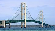
northbound ends with traffic merging onto northbound I-75 and the southbound starts taking drivers through the center of the state granting easier access to cities such as Clare, Mt. Pleasant, Lansing, and Jackson. At Mackinaw City
, I-75 crosses the Mackinac Bridge
to reach the Upper Peninsula. It is the only Interstate located in the Upper Peninsula of Michigan, and it continues to where the road terminates at the Canadian border in Sault Ste. Marie
.
On the Canadian side, drivers must use a series of city streets in Sault Ste. Marie, Ontario
to reach Highway 17
, the local route of the Trans-Canada Highway
.
, U.S. Route 27
, U.S. Route 25
, and U.S. Route 41
, among others. Some of these older U.S. Routes (several of which are still in existence) previously had replaced the eastern route of the old Dixie Highway
.
Interstate 75 was planned to end in Tampa, Florida
, in the original plan for 41,000 miles of interstate highways. However, beginning in the 1960s, there was a huge growth in the population of southwestern Florida (Sarasota, Ft. Myers, Naples, Cape Coral, etc.), hence the need for new highways, especially a north-south expressway, as well as one connecting Florida's Gulf Coast to South Florida. At first, Florida state legislators proposed a toll in the new highway, but by 1968, it was decided that the Federal Government would pay 90% towards the extension of I-75 to southwestern and southeastern Florida. This included subsuming a privately-owned toll highway from Naples to the Fort Lauderdale area, the Alligator Alley
, and furthermore to connect this expressway with Interstate 95 in North Miami -- though due to some local opposition, I-75 presently ends a few miles short of I-95.
On December 21, 1977, I-75 was completed from Tampa to Sault Ste. Marie with its final segment opening between northern Marietta, Georgia
, and Cartersville, Georgia
. Then the final stretch of Interstate 75 in South Florida was completed in 1986 in Miami-Dade County and Broward County, but the last stretch to receive the signs for I - 75 was the reconstructed (rebuilt and widened) Alligator Alley
on November 25, 1992.

Great Lakes
The Great Lakes are a collection of freshwater lakes located in northeastern North America, on the Canada – United States border. Consisting of Lakes Superior, Michigan, Huron, Erie, and Ontario, they form the largest group of freshwater lakes on Earth by total surface, coming in second by volume...
and Southeastern
Southeastern United States
The Southeastern United States, colloquially referred to as the Southeast, is the eastern portion of the Southern United States. It is one of the most populous regions in the United States of America....
regions of the United States
United States
The United States of America is a federal constitutional republic comprising fifty states and a federal district...
. It travels from State Road 826
State Road 826 (Florida)
State Road 826, also known as the Palmetto Expressway, is a bypass route around the greater Miami area, extending from U.S. Route 1 in Pinecrest, going through the inner Miami suburbs in a north-east semicircle to the Golden Glades Interchange, reverting to a surface street to its terminus at...
(Palmetto Expressway) and State Road 924
State Road 924 (Florida)
State Road 924 is a east–west highway connecting Interstate 75 and the Palmetto Expressway in Hialeah and SR 909 in North Miami...
(Gratigny Parkway) in Hialeah, Florida
Hialeah, Florida
Hialeah is a city in Miami-Dade County, Florida, United States. As of the 2000 census, the city population was 226,419. As of 2009, the population estimate by the U. S...
(northwest of Miami
Miami, Florida
Miami is a city located on the Atlantic coast in southeastern Florida and the county seat of Miami-Dade County, the most populous county in Florida and the eighth-most populous county in the United States with a population of 2,500,625...
) to Sault Ste. Marie, Michigan
Sault Ste. Marie, Michigan
Sault Ste. Marie is a city in and the county seat of Chippewa County in the U.S. state of Michigan. It is in the north-eastern end of Michigan's Upper Peninsula, on the Canadian border, separated from its twin city of Sault Ste. Marie, Ontario, by the St. Marys River...
, at the Ontario
Ontario
Ontario is a province of Canada, located in east-central Canada. It is Canada's most populous province and second largest in total area. It is home to the nation's most populous city, Toronto, and the nation's capital, Ottawa....
, Canada
Canada
Canada is a North American country consisting of ten provinces and three territories. Located in the northern part of the continent, it extends from the Atlantic Ocean in the east to the Pacific Ocean in the west, and northward into the Arctic Ocean...
, border. Interstate 75 passes through six different states: Florida
Florida
Florida is a state in the southeastern United States, located on the nation's Atlantic and Gulf coasts. It is bordered to the west by the Gulf of Mexico, to the north by Alabama and Georgia and to the east by the Atlantic Ocean. With a population of 18,801,310 as measured by the 2010 census, it...
, Georgia
Georgia (U.S. state)
Georgia is a state located in the southeastern United States. It was established in 1732, the last of the original Thirteen Colonies. The state is named after King George II of Great Britain. Georgia was the fourth state to ratify the United States Constitution, on January 2, 1788...
, Tennessee
Tennessee
Tennessee is a U.S. state located in the Southeastern United States. It has a population of 6,346,105, making it the nation's 17th-largest state by population, and covers , making it the 36th-largest by total land area...
, Kentucky
Kentucky
The Commonwealth of Kentucky is a state located in the East Central United States of America. As classified by the United States Census Bureau, Kentucky is a Southern state, more specifically in the East South Central region. Kentucky is one of four U.S. states constituted as a commonwealth...
, Ohio
Ohio
Ohio is a Midwestern state in the United States. The 34th largest state by area in the U.S.,it is the 7th‑most populous with over 11.5 million residents, containing several major American cities and seven metropolitan areas with populations of 500,000 or more.The state's capital is Columbus...
and Michigan
Michigan
Michigan is a U.S. state located in the Great Lakes Region of the United States of America. The name Michigan is the French form of the Ojibwa word mishigamaa, meaning "large water" or "large lake"....
.
Due to traffic levels on the Interstate, much of the route is six lanes even in rural areas. The longest continuous segment of six-lane (or more) Interstate is along I-75 from the Florida's Turnpike
Florida's Turnpike
Florida's Turnpike , designated as the Ronald Reagan Turnpike, and originally known as the Sunshine State Parkway is a north–south toll road that runs through 11 counties in the Florida peninsula, from U.S...
junction in Wildwood, Florida
Wildwood, Florida
Wildwood is a city in Sumter County, Florida, United States. The population was 3,924 at the 2000 census. According to the U.S. Census Bureau's 2004 estimates, the city had a population of 3,598.-Geography:Wildwood is located at ....
to I-24 in the Chattanooga area, using I-475 to bypass Macon, Georgia
Macon, Georgia
Macon is a city located in central Georgia, US. Founded at the fall line of the Ocmulgee River, it is part of the Macon metropolitan area, and the county seat of Bibb County. A small portion of the city extends into Jones County. Macon is the biggest city in central Georgia...
.
Route description
|-|FL
Interstate 75 in Florida
Interstate 75 is a part of the Interstate Highway System and runs from Hialeah, Florida, a few miles northwest of Miami to Sault Ste. Marie in the Upper Peninsula of Michigan...
|| 470.88 || 757.81
|-
|GA
Interstate 75 in Georgia
In the U.S. state of Georgia, Interstate 75 runs north–south along the U.S. Route 41 corridor on the western side of the state, passing through the cities of Valdosta, Macon and Atlanta. It is also designated — but not signed — as State Route 401...
|| 355.11 || 571.49
|-
|TN
Interstate 75 in Tennessee
In the U.S. state of Tennessee, Interstate 75 runs from Chattanooga to Jellico by way of Knoxville. Interstate 75 enters the East Tennessee region following the Tennessee Valley from Georgia, all the way through Knoxville to near Lake City, then climbs into the Cumberland Mountains before crossing...
|| 161.86 || 260.49
|-
|KY || 191.78 || 308.64
|-
|OH
Interstate 75 in Ohio
In the U.S. state of Ohio, Interstate 75 runs from Cincinnati to Toledo by way of Dayton. I-75 enters Ohio concurrent with I-71 from Kentucky on the Brent Spence Bridge over the Ohio River and into the Bluegrass region...
|| 211.30 || 340.05
|-
|MI
Interstate 75 in Michigan
Interstate 75 is a part of the Interstate Highway System and runs from Miami, Florida to Sault Ste. Marie in the Upper Peninsula of Michigan. I-75 enters the state from Ohio in the south, just to the north of Toledo. It runs generally north through Detroit, Pontiac and Bay City, crossing the...
|| 395.54 || 636.56
|-
|Total || 1786.47 || 2875.04
|}
Florida
Interstate 75 begins its northerly journey at an interchange with State Road 924 and State Road 826 in Hialeah, a suburb of Miami. After an intersection with the Homestead Extension of Florida's TurnpikeHomestead Extension of Florida's Turnpike
Homestead Extension of Florida's Turnpike , designated as the Ronald Reagan Turnpike, and originally known as the West Dade Expressway is a north–south free-flow toll road southern extension of the tolled Florida's Turnpike...
and an interchange with Interstate 595
Interstate 595
Interstate 595 may refer to:*Interstate 595 , a spur from I-75 across I-95 to Fort Lauderdale, Florida*Interstate 595 , an unsigned spur to Annapolis, Maryland...
and the Sawgrass Expressway
Sawgrass Expressway
State Road 869 is a long state road located in Broward County, Florida. The road acts as a de-facto bypass of Fort Lauderdale and northern coastal Broward County, Florida, extending north from a junction of Interstate 75 , Interstate 595 , and SR 84 in Sunrise, to Coral Springs before heading...
, the interstate leaves the Miami metropolitan area and turns westward to travel through the Everglades
Everglades
The Everglades are subtropical wetlands in the southern portion of the U.S. state of Florida, comprising the southern half of a large watershed. The system begins near Orlando with the Kissimmee River, which discharges into the vast but shallow Lake Okeechobee...
along the tolled Alligator Alley
Alligator Alley
Alligator Alley is a section of Interstate 75 and State Road 84 extending from Naples on the west coast of Florida to Weston on the east...
, which brings the highway to the Gulf Coast and Naples
Naples, Florida
Naples is a city in Collier County, Florida, United States. As of July 1, 2007, the U.S. Census Bureau estimated the city's population at 21,653. Naples is a principal city of the Naples–Marco Island Metropolitan Statistical Area, which had an estimated total population of 315,839 on July 1, 2007...
, where it again heads north. Passing through Bonita Springs
Bonita Springs, Florida
Bonita Springs is a city in Lee County, Florida, United States. The population was 43,914 at the 2010 census. It is part of the Cape Coral–Fort Myers Metropolitan Statistical Area. The city is located on the southwest coast of the state....
, Fort Myers, and Sarasota, Interstate 75 encounters a series of construction projects that will increase the lane count from two lanes in each direction to three in each direction. The freeway enters the Tampa Bay
Tampa Bay
Tampa Bay is a large natural harbor and estuary along the Gulf of Mexico on the west central coast of Florida, comprising Hillsborough Bay, Old Tampa Bay, Middle Tampa Bay, and Lower Tampa Bay."Tampa Bay" is not the name of any municipality...
metropolitan area before the interchange with Interstate 275
Interstate 275 (Florida)
Interstate 275 in Florida serves the Tampa Bay metropolitan area, measuring 60.696 miles in length. The southern terminus is I-75 near Palmetto, just five miles east of the Sunshine Skyway Bridge, a toll bridge crossing Tampa Bay. The highway passes through St...
northbound, which handles St. Petersburg-bound traffic. Within the Tampa metro are three more major junctions: One with the Lee Roy Selmon Expressway which carries traffic into downtown Tampa; one with Interstate 4
Interstate 4
Interstate 4 is a intrastate Highway located entirely within the state of Florida, United States. It goes from Interstate 275 in Tampa, Florida to Interstate 95 at Daytona Beach, Florida . It also has the Florida Department of Transportation designation of State Road 400, but only a small...
which carries traffic across the center of the state to the East Coast; and another as Interstate 275 traffic defaults back onto northbound. The freeway proceeds to enter suburban portions of Pasco, Hernando, and Sumter counties on its way to Ocala and Gainesville
Gainesville, Florida
Gainesville is the largest city in, and the county seat of, Alachua County, Florida, United States as well as the principal city of the Gainesville, Florida Metropolitan Statistical Area . The preliminary 2010 Census population count for Gainesville is 124,354. Gainesville is home to the sixth...
. At Lake City, Florida
Lake City, Florida
Lake City is the county seat of Columbia County, Florida, in the United States. In 2009, the U.S. Census Bureau estimated the city's population at 12,614. In addition, it is the Principal City of the Lake City Micropolitan Statistical Area, which is composed of Columbia County, and had an...
, the Christopher Columbus Transcontinental Highway, Interstate 10
Interstate 10
Interstate 10 is the fourth-longest Interstate Highway in the United States, after I-90, I-80, and I-40. It is the southernmost east–west, coast-to-coast Interstate Highway, although I-4 and I-8 are further south. It stretches from the Pacific Ocean at State Route 1 in Santa Monica,...
, intersects with Interstate 75, providing routes toward Jacksonville, Florida
Jacksonville, Florida
Jacksonville is the largest city in the U.S. state of Florida in terms of both population and land area, and the largest city by area in the contiguous United States. It is the county seat of Duval County, with which the city government consolidated in 1968...
; Tallahassee; Mobile, Alabama
Mobile, Alabama
Mobile is the third most populous city in the Southern US state of Alabama and is the county seat of Mobile County. It is located on the Mobile River and the central Gulf Coast of the United States. The population within the city limits was 195,111 during the 2010 census. It is the largest...
; New Orleans, Louisiana
New Orleans, Louisiana
New Orleans is a major United States port and the largest city and metropolitan area in the state of Louisiana. The New Orleans metropolitan area has a population of 1,235,650 as of 2009, the 46th largest in the USA. The New Orleans – Metairie – Bogalusa combined statistical area has a population...
; and points westward. Afterward, the northmost stetch of Interstate 75 in Florida exits the Sunshine State into southern Georgia
Georgia (U.S. state)
Georgia is a state located in the southeastern United States. It was established in 1732, the last of the original Thirteen Colonies. The state is named after King George II of Great Britain. Georgia was the fourth state to ratify the United States Constitution, on January 2, 1788...
.
Georgia
Interstate 75 enters GeorgiaGeorgia (U.S. state)
Georgia is a state located in the southeastern United States. It was established in 1732, the last of the original Thirteen Colonies. The state is named after King George II of Great Britain. Georgia was the fourth state to ratify the United States Constitution, on January 2, 1788...
near Lake Park
Lake Park, Georgia
Lake Park is a city in Lowndes County, Georgia, United States. The population was 549 at the 2000 census.-Geography:Lake Park is located at ....
, and it continues northward through the towns of Valdosta, Tifton and Cordele until it reaches the Macon
Macon, Georgia
Macon is a city located in central Georgia, US. Founded at the fall line of the Ocmulgee River, it is part of the Macon metropolitan area, and the county seat of Bibb County. A small portion of the city extends into Jones County. Macon is the biggest city in central Georgia...
area, where it intersects with Interstate 16
Interstate 16
Interstate 16 , also known as Jim Gillis Historic Savannah Parkway or State Route 404 , is an intrastate Interstate Highway located entirely within the state of Georgia, United States...
eastbound towards Savannah
Savannah, Georgia
Savannah is the largest city and the county seat of Chatham County, in the U.S. state of Georgia. Established in 1733, the city of Savannah was the colonial capital of the Province of Georgia and later the first state capital of Georgia. Today Savannah is an industrial center and an important...
. For northbound traffic wishing to avoid potential congestion in Macon, Interstate 475
Interstate 475 (Georgia)
Interstate 475 is a long Interstate highway in Georgia, splitting off from Interstate 75 and bypassing Macon, Georgia. It is also unsigned State Route 408...
provides a relatively straight bypass west of that city and Interstate 75's route. After Macon it passes the small town of Forsyth. The freeway reaches no major junctions again until in the Atlanta metropolitan area. The first metropolitan freeway met is Interstate 675
Interstate 675 (Georgia)
Interstate 675 was built in southeast metro Atlanta during the mid-1980s to alleviate Interstate 75 to the west, for traffic bound to Interstate 285 east. It is 11.04 miles in length, running from I-75 in the south from the city of Stockbridge to I-285 at its north end...
, then followed by the Atlanta "Perimeter" bypass, Interstate 285
Interstate 285
Interstate 285 is an Interstate Highway loop encircling Atlanta, Georgia, for . I-285 is also known as unsigned State Route 407 and is colloquially referred to as the Perimeter. Suburban sprawl has made it one of the most heavily traveled roadways in the United States, and portions of the highway...
. It crosses inside the Perimeter and heads north several miles towards the Atlanta city center. Interstate 75 is then duplexed with Interstate 85
Interstate 85
Interstate 85 is a major interstate highway in the Southeastern United States. Its current southern terminus is at an interchange with Interstate 65 in Montgomery, Alabama; its northern terminus interchanges with Interstate 95 in Petersburg, Virginia, near Richmond...
due north over the Downtown Connector
Downtown Connector
In Atlanta, Georgia, the Downtown Connector or 75/85 is the concurrent section of Interstate 75 and Interstate 85 through the core of the city. Beginning at the I-85/Langford Parkway interchange, the Downtown Connector runs generally due north, meeting the east-west Interstate 20 in the middle....
through the central business district of Atlanta. After the two Interstates split, Interstate 75 makes a beeline northwest, crossing outside the Interstate 285 Perimeter and heading towards the major suburban city of Marietta
Marietta, Georgia
Marietta is a city located in central Cobb County, Georgia, United States, and is its county seat.As of the 2010 census, the city had a total population of 56,579, making it one of metro Atlanta's largest suburbs...
. This section of Interstate 75 just north of Interstate 285 has 15 through lanes, making it the widest roadway anywhere in the Interstate Highway System. North of Marietta, the final major junction in the Atlanta metropolitan area is the Interstate 575
Interstate 575
Interstate 575 is an Interstate Highway spur route in the United States, which branches off Interstate 75 in Kennesaw and connects the metro Atlanta area with the north Georgia mountains. I-575 is also the unsigned State Route 417 and is cosigned as SR 5...
spur. Interstate 75 then traverses the hilly northwestern Georgia terrain as it travels towards Chattanooga, Tennessee
Tennessee
Tennessee is a U.S. state located in the Southeastern United States. It has a population of 6,346,105, making it the nation's 17th-largest state by population, and covers , making it the 36th-largest by total land area...
.
Tennessee
The freeway enters TennesseeTennessee
Tennessee is a U.S. state located in the Southeastern United States. It has a population of 6,346,105, making it the nation's 17th-largest state by population, and covers , making it the 36th-largest by total land area...
directly in the Chattanooga metropolitan area, where it intersects with Interstate 24
Interstate 24
Interstate 24 is an Interstate Highway in the Midwestern and Southeastern United States. It runs diagonally from Interstate 57 to Chattanooga, Tennessee, at Interstate 75....
. Exiting Chattanooga to the northeast, Interstate 75 passes through an area known for dense fog. Twelve people were killed and 42 were injured in a 99 vehicle accident on that stretch of I-75 in heavy fog on December 11, 1990. Interstate 75 does not meet any other highways until it is multiplexed with Interstate 40
Interstate 40
Interstate 40 is the third-longest major east–west Interstate Highway in the United States, after I-90 and I-80. Its western end is at Interstate 15 in Barstow, California; its eastern end is at a concurrency of U.S. Route 117 and North Carolina Highway 132 in Wilmington, North Carolina...
and heads eastbound. Together, they enter the outskirts of Knoxville, where Interstate 75 multiplexes itself with a different road, this time Interstate 640
Interstate 640
Interstate 640 is a bypass of Interstate 40 running north of Knoxville, Tennessee. For many years only about a two-mile segment of it between State Route 33 and U.S. Highway 25W was open. Finally, the road was completed in anticipation of the traffic which was to be generated by the 1982...
, but only for a short time. When the two meet Interstate 275
Interstate 275 (Tennessee)
Interstate 275 is an Interstate Highway in Tennessee that serves Knoxville by connecting the downtown with I-75 and I-640. Measuring 2.98 miles in length, the northern terminus is the junction with I-75 and I-640 and the southern terminus is I-40....
, Interstate 75 becomes its own freeway and heads north towards the Kentucky
Kentucky
The Commonwealth of Kentucky is a state located in the East Central United States of America. As classified by the United States Census Bureau, Kentucky is a Southern state, more specifically in the East South Central region. Kentucky is one of four U.S. states constituted as a commonwealth...
border. On the journey northward from Knoxville to the Kentucky
Kentucky
The Commonwealth of Kentucky is a state located in the East Central United States of America. As classified by the United States Census Bureau, Kentucky is a Southern state, more specifically in the East South Central region. Kentucky is one of four U.S. states constituted as a commonwealth...
border, interstate 75 encounters some of its highest points of elevation through the Cumberland Mountains
Cumberland Mountains
The Cumberland Mountains are a mountain range in the southeastern section of the Appalachian Mountains. They are located in southern West Virginia, western Virginia, eastern edges of Kentucky, and eastern middle Tennessee, including the Crab Orchard Mountains...
and Cumberland Plateau
Cumberland Plateau
The Cumberland Plateau is the southern part of the Appalachian Plateau. It includes much of eastern Kentucky and western West Virginia, part of Tennessee, and a small portion of northern Alabama and northwest Georgia . The terms "Allegheny Plateau" and the "Cumberland Plateau" both refer to the...
region, cutting through the uppermost peaks and ridges of the mountains.
Kentucky
Interstate 75 continues northbound through the hilly, rugged terrain of the Cumberland PlateauCumberland Plateau
The Cumberland Plateau is the southern part of the Appalachian Plateau. It includes much of eastern Kentucky and western West Virginia, part of Tennessee, and a small portion of northern Alabama and northwest Georgia . The terms "Allegheny Plateau" and the "Cumberland Plateau" both refer to the...
region of Kentucky
Kentucky
The Commonwealth of Kentucky is a state located in the East Central United States of America. As classified by the United States Census Bureau, Kentucky is a Southern state, more specifically in the East South Central region. Kentucky is one of four U.S. states constituted as a commonwealth...
passing through London
London, Kentucky
-Education:All of the following schools are administered by the Laurel County School District.-Primary schools:* * * * * * * * * * * * -High schools:* * -Colleges:* Laurel Technical College* * -Notable natives:...
and Richmond
Richmond, Kentucky
There were 10,795 households out of which 24.4% had children under the age of 18 living with them, 35.2% were married couples living together, 12.8% had a female householder with no husband present, and 48.6% were non-families. Of all households, 34.7% were made up of individuals and 8.8% had...
, eventually reaching Lexington
Lexington, Kentucky
Lexington is the second-largest city in Kentucky and the 63rd largest in the US. Known as the "Thoroughbred City" and the "Horse Capital of the World", it is located in the heart of Kentucky's Bluegrass region...
, where it briefly runs coterminously with Interstate 64
Interstate 64
Interstate 64 is an Interstate Highway in the Midwestern and Southeastern United States. Its western terminus is at I-70, U.S. 40, and U.S. 61 in Wentzville, Missouri. Its eastern terminus is at an interchange with I-264 and I-664 at Bowers Hill in Chesapeake, Virginia. As I-64 is concurrent with...
before splitting off for Cincinnati, Ohio
Cincinnati, Ohio
Cincinnati is a city in the U.S. state of Ohio. Cincinnati is the county seat of Hamilton County. Settled in 1788, the city is located to north of the Ohio River at the Ohio-Kentucky border, near Indiana. The population within city limits is 296,943 according to the 2010 census, making it Ohio's...
. Near Walton, Interstate 71
Interstate 71
Interstate 71 is an Interstate Highway in the Great Lakes/Midwestern and Southeastern region of the United States. Its southern terminus is at an interchange with Interstate 64 and Interstate 65 in Louisville, Kentucky. Its northern terminus is at an interchange with Interstate 90 in Cleveland,...
merges with Interstate 75, making for yet another multiplexed portion of freeway. Interstate 275
Interstate 275 (Ohio)
Interstate 275 is an loop in Ohio, Indiana, and Kentucky that forms a complete beltway around the Cincinnati, Ohio area. It is the only auxiliary interstate that enters three states, including one state that the parent route does not enter . It is the longest loop interstate highway in the United...
, which is the Cincinnati beltway, is then intersected by Interstate 71/75. After passing through Covington
Covington, Kentucky
-Demographics:As of the census of 2000, there were 43,370 people, 18,257 households, and 10,132 families residing in the city. The population density was 3,301.3 people per square mile . There were 20,448 housing units at an average density of 1,556.5 per square mile...
, the freeway crosses the Ohio River
Ohio River
The Ohio River is the largest tributary, by volume, of the Mississippi River. At the confluence, the Ohio is even bigger than the Mississippi and, thus, is hydrologically the main stream of the whole river system, including the Allegheny River further upstream...
via the lower level of the Brent Spence Bridge
Brent Spence Bridge
The Brent Spence Bridge is a double decker cantilever truss bridge that carries Interstates 71 and 75 across the Ohio River between Covington, Kentucky and Cincinnati, Ohio. The top deck carries southbound traffic while the bottom deck carries northbound traffic. It is arguably the most important...
and continues into Cincinnati.
Ohio
Immediately after entering Cincinnati, Interstate 71Interstate 71
Interstate 71 is an Interstate Highway in the Great Lakes/Midwestern and Southeastern region of the United States. Its southern terminus is at an interchange with Interstate 64 and Interstate 65 in Louisville, Kentucky. Its northern terminus is at an interchange with Interstate 90 in Cleveland,...
separates from Interstate 75, taking a more easterly routing through the city, while Interstate 75 remains generally northbound throughout the metropolitan area. Interstate 74
Interstate 74
Interstate 74 is an Interstate Highway in the Midwestern and Southeastern United States. Its western end is at an intersection with Interstate 80 in Davenport, Iowa; the eastern end of its Midwest segment is at an intersection with Interstate 75 in Cincinnati, Ohio...
westbound, Ohio State Route 562 eastbound, and Ohio State Route 126 all intersect the freeway as it makes its way northward. In Arlington Heights, a suburb of Cincinnati, Interstate 75 sees a carriageway split for a few miles. After another interchange with the Interstate 275
Interstate 275 (Ohio)
Interstate 275 is an loop in Ohio, Indiana, and Kentucky that forms a complete beltway around the Cincinnati, Ohio area. It is the only auxiliary interstate that enters three states, including one state that the parent route does not enter . It is the longest loop interstate highway in the United...
beltway, the freeway continues in the metropolitan area, passes through Middletown
Middletown, Ohio
Middletown is an All-America City located in Butler and Warren counties in the southwestern part of the U.S. state of Ohio. Formerly in Lemon, Turtlecreek, and Franklin townships, Middletown was incorporated by the Ohio General Assembly on February 11, 1833, and became a city in 1886...
and heads towards Dayton
Dayton, Ohio
Dayton is the 6th largest city in the U.S. state of Ohio and the county seat of Montgomery County, the fifth most populous county in the state. The population was 141,527 at the 2010 census. The Dayton Metropolitan Statistical Area had a population of 841,502 in the 2010 census...
, where Interstate 675
Interstate 675 (Ohio)
Interstate 675 is an auxiliary interstate highway in the suburbs of Dayton in the U.S. state of Ohio. Interstate 675 serves as an eastern bypass of Dayton. I-675 measures in length...
, Interstate 70
Interstate 70
Interstate 70 is an Interstate Highway in the United States that runs from Interstate 15 near Cove Fort, Utah, to a Park and Ride near Baltimore, Maryland. It was the first Interstate Highway project in the United States. I-70 approximately traces the path of U.S. Route 40 east of the Rocky...
, and U.S. Route 35, have interchanges. The intersection of Interstate 75 with Interstate 70 is known as the Freedom Veterans Crossroads. After exiting the city of Dayton, Interstate 75 makes its way northbound through Ohio, passing through the smaller cities of Wapakoneta
Wapakoneta, Ohio
Wapakoneta is a city in and the county seat of Auglaize County, Ohio, United States with a population of 9,474 as of the 2000 U.S. census. It is the principal city of and is included in the Wapakoneta, Ohio Micropolitan S A, which is included in the Lima-Van Wert-Wapakoneta, Ohio CSA...
, Lima
Lima, Ohio
Lima is a city in and the county seat of Allen County, Ohio, United States. The municipality is located in northwestern Ohio along Interstate 75 approximately north of Dayton and south-southwest of Toledo....
, Findlay
Findlay, Ohio
As of the census of 2000, there were 38,967 people, 15,905 households, and 10,004 families residing in the city. The population density was 2,266.3 people per square mile . There were 17,152 housing units at an average density of 997.6 per square mile...
and Bowling Green
Bowling Green, Ohio
Bowling Green is the county seat of Wood County in the U.S. state of Ohio. At the time of the 2010 census, the population of Bowling Green was 30,028. It is part of the Toledo, Ohio Metropolitan Statistical Area. Bowling Green is the home of Bowling Green State University...
before finally reaching Toledo
Toledo, Ohio
Toledo is the fourth most populous city in the U.S. state of Ohio and is the county seat of Lucas County. Toledo is in northwest Ohio, on the western end of Lake Erie, and borders the State of Michigan...
, located on the Michigan
Michigan
Michigan is a U.S. state located in the Great Lakes Region of the United States of America. The name Michigan is the French form of the Ojibwa word mishigamaa, meaning "large water" or "large lake"....
border. Interstate 475
Interstate 475 (Ohio)
Interstate 475 is an Interstate Highway in Ohio that is a western bypass of Toledo. The southern terminus is I-75 near Perrysburg. The northern terminus is I-75 near downtown Toledo...
is met first south of the city, and then the cross-country highways of Interstate 80
Interstate 80
Interstate 80 is the second-longest Interstate Highway in the United States, following Interstate 90. It is a transcontinental artery running from downtown San Francisco, California to Teaneck, New Jersey in the New York City Metropolitan Area...
/Interstate 90
Interstate 90
Interstate 90 is the longest Interstate Highway in the United States at . It is the northernmost coast-to-coast interstate, and parallels US 20 for the most part. Its western terminus is in Seattle, at Edgar Martinez Drive S. near Safeco Field and CenturyLink Field, and its eastern terminus is in...
/Ohio Turnpike
Ohio Turnpike
The Ohio Turnpike, officially the James W. Shocknessy Ohio Turnpike, is a -long, limited-access toll highway in the U.S. state of Ohio, serving as a primary corridor to Chicago and Pittsburgh...
. Interstate 475 then meets with 75 again. Interstate 280
Interstate 280 (Ohio)
Interstate 280 is a 12.41-mile-long highway that connects I-75 in northeast Toledo, Ohio with I-80/I-90 southeast of the city in northeastern Wood County, Ohio....
is the last major junction in Ohio; the freeway crosses into Michigan soon afterwards.
Michigan
Interstate 75 hugs the western shore of Lake ErieLake Erie
Lake Erie is the fourth largest lake of the five Great Lakes in North America, and the tenth largest globally. It is the southernmost, shallowest, and smallest by volume of the Great Lakes and therefore also has the shortest average water residence time. It is bounded on the north by the...
upon entering Michigan—until about Monroe
Monroe, Michigan
Monroe is a city in the U.S. state of Michigan. The population was 20,733 at the 2010 census. It is the largest city and county seat of Monroe County. The city is bordered on the south by Monroe Charter Township, but both are politically independent. The city is located approximately 14 miles ...
, when it heads north eastward and prepares to enter Detroit and its surrounding suburb
Suburb
The word suburb mostly refers to a residential area, either existing as part of a city or as a separate residential community within commuting distance of a city . Some suburbs have a degree of administrative autonomy, and most have lower population density than inner city neighborhoods...
s. Yet another I-275
Interstate 275 (Michigan)
Interstate 275 in the US state of Michigan is an Interstate Highway that functions as a western bypass of the Detroit metropolitan area. The Michigan Department of Transportation maintains it as a component of the larger state trunkline highway system. The freeway runs through the western suburbs...
is met as the freeway goes deeper into the Detroit metropolitan area, and no other major junctions are present until downtown. Once downtown, Interstate 75 meets the Ambassador Bridge
Ambassador Bridge
The Ambassador Bridge is a suspension bridge that connects Detroit, Michigan, in the United States, with Windsor, Ontario, in Canada. It is the busiest international border crossing in North America in terms of trade volume: more than 25 percent of all merchandise trade between the United States...
to Windsor, Ontario
Windsor, Ontario
Windsor is the southernmost city in Canada and is located in Southwestern Ontario at the western end of the heavily populated Quebec City – Windsor Corridor. It is within Essex County, Ontario, although administratively separated from the county government. Separated by the Detroit River, Windsor...
, Interstate 375
Interstate 375 (Michigan)
The unsigned Business Spur Interstate 375 , which is long, continues west on Jefferson Avenue from the southern end of I-375, ending at the entrance to the Detroit–Windsor Tunnel at Randolph Street . Jefferson Avenue past that intersection is M-10, quickly becoming the Lodge Freeway. BS I-375 runs...
(Chrysler Freeway), I-94
Interstate 94
Interstate 94 is the northernmost east–west Interstate Highway, connecting the Great Lakes and Intermountain regions of the United States. I-94's western terminus is in Billings, Montana at a junction with Interstate 90; its eastern terminus is the U.S...
, I-96
Interstate 96
Interstate 96 is an intrastate Interstate Highway that is entirely within the US state of Michigan. Its western terminus is at an interchange with US Highway 31 and Business US Highway 31 , on the western boundary of Norton Shores southeast of Muskegon. Its eastern terminus is at I-75 near the...
, M-10
M-10 (Michigan highway)
M-10, is a state trunkline route in the US state of Michigan. The southernmost portion follows Jefferson Avenue in downtown Detroit, and the southern terminus is at the intersection of Jefferson and Randolph Street leading to the entrance to the Detroit–Windsor Tunnel...
and M-8
M-8 (Michigan highway)
M-8 is a state trunkline highway in the U.S. state of Michigan lying within the cities of Detroit and Highland Park. Much of it is the Davison Freeway, the nation's first urban depressed freeway, which became a connector between the Lodge and the Chrysler Freeways.Named for an English immigrant...
(Davison Freeway). I-696
Interstate 696
Interstate 696 is an intrastate Interstate Highway entirely within the US state of Michigan. I-696 is also known as the Walter P. Reuther Freeway, named for a prominent figure in early automobile factory labor union activity. I-696 is a spur route, partially circling the city of Detroit, but...
also intersects I-75 in the northern metro area. There is a junction with Big Beaver Road at exit 69, easily one of the more memorable exits on the Interstate system. http://www.getoffonbigbeaver.com/ When the freeway reaches Pontiac
Pontiac, Michigan
Pontiac is a city in the U.S. state of Michigan named after the Ottawa Chief Pontiac, located within the Detroit metropolitan area. As of the 2010 census, the city had a total population of 59,515. It is the county seat of Oakland County...
, there is a junction with M-59
M-59 (Michigan highway)
M-59 is an east–west state trunkline highway that crosses the northern part of Metropolitan Detroit in the US state of Michigan. It runs between Howell at Interstate 96 and I-94 on the Chesterfield Township – Harrison Township line near the Selfridge Air National Guard Base...
; and further north in Flint
Flint, Michigan
Flint is a city in the U.S. state of Michigan and is located along the Flint River, northwest of Detroit. The U.S. Census Bureau reports the 2010 population to be placed at 102,434, making Flint the seventh largest city in Michigan. It is the county seat of Genesee County which lies in the...
, the interstate meets I-475
Interstate 475 (Michigan)
Interstate 475 is an Interstate Highway in the US state of Michigan. I-475 is a bypass route that serves the downtown area of Flint while its parent, I-75, passes through the west side of the city...
and I-69
Interstate 69
Interstate 69 is an Interstate Highway in the United States. It exists in two parts: a completed highway from Indianapolis, Indiana, northeast to the Canadian border in Port Huron, Michigan, and a mostly proposed extension southwest to the Mexican border in Texas...
. The freeway then heads north towards Saginaw
Saginaw, Michigan
Saginaw is a city in the U.S. state of Michigan and the seat of Saginaw County. The city of Saginaw was once a thriving lumber town and manufacturing center. Saginaw and Saginaw County lie in the Flint/Tri-Cities region of Michigan...
, where I-675
Interstate 675 (Michigan)
Interstate 675 is an Interstate Highway in the US state of Michigan. I-675 is a loop route through downtown Saginaw as I-75 passes on the east side of the city....
acts as a spur route into the city. Further north in Bay City
Bay City, Michigan
Bay City is a city in the U.S. state of Michigan located near the base of the Saginaw Bay on Lake Huron. As of the 2010 census, the city's population was 34,932, and is the principal city of the Bay City Metropolitan Statistical Area, which is included in the Saginaw-Bay City-Saginaw Township North...
, the major junction of US 10
U.S. Route 10
U.S. Route 10 is an east–west United States highway formed in 1926. Though it never became the cross-country highway suggested by the "0" as the last digit of its route number, U.S...
exists, providing access to Midland
Midland, Michigan
Midland is a city in the U.S. state of Michigan in the Tri-Cities region of the state. It is the county seat of Midland County. The city's population was 41,863 as of the 2010 census. It is the principal city of the Midland Micropolitan Statistical Area....
as well as downtown Bay City. The last major interchange occurs at 4 Mile Road just south of Grayling where US 127
U.S. Route 127
U.S. Route 127 is a long north–south United States highway in the eastern half of the United States. The southern terminus of the route is at U.S. Route 27 in Chattanooga, Tennessee. The northern terminus is at Interstate 75 near Grayling, Michigan...
northbound ends with traffic merging onto northbound I-75 and the southbound starts taking drivers through the center of the state granting easier access to cities such as Clare, Mt. Pleasant, Lansing, and Jackson. At Mackinaw City
Mackinaw City, Michigan
Mackinaw City is a village in Emmet and Cheboygan counties in the U.S. state of Michigan. At the 2000 census the population was 859. The name "Mackinaw City" is a bit of a misnomer as it is actually a village...
, I-75 crosses the Mackinac Bridge
Mackinac Bridge
The Mackinac Bridge is a suspension bridge spanning the Straits of Mackinac to connect the non-contiguous Upper and Lower peninsulas of the U.S. state of Michigan. Opened in 1957, the bridge is the third longest in total suspension in the world and the longest suspension bridge between anchorages...
to reach the Upper Peninsula. It is the only Interstate located in the Upper Peninsula of Michigan, and it continues to where the road terminates at the Canadian border in Sault Ste. Marie
Sault Ste. Marie, Michigan
Sault Ste. Marie is a city in and the county seat of Chippewa County in the U.S. state of Michigan. It is in the north-eastern end of Michigan's Upper Peninsula, on the Canadian border, separated from its twin city of Sault Ste. Marie, Ontario, by the St. Marys River...
.
On the Canadian side, drivers must use a series of city streets in Sault Ste. Marie, Ontario
Sault Ste. Marie, Ontario
Sault Ste. Marie is a city on the St. Marys River in Algoma District, Ontario, Canada. It is the third largest city in Northern Ontario, after Sudbury and Thunder Bay, with a population of 74,948. The community was founded as a French religious mission: Sault either means "jump" or "rapids" in...
to reach Highway 17
Highway 17 (Ontario)
King's Highway 17, more commonly known as Highway 17, is a provincially maintained highway and the primary route of the Trans-Canada Highway through the Canadian province of Ontario. It begins at the Manitoba border west of Kenora and ends south of Arnprior at the western terminus of Highway 417, ...
, the local route of the Trans-Canada Highway
Trans-Canada Highway
The Trans-Canada Highway is a federal-provincial highway system that joins the ten provinces of Canada. It is, along with the Trans-Siberian Highway and Australia's Highway 1, one of the world's longest national highways, with the main route spanning 8,030 km...
.
History
This limited access highway that was planned in the 1950s roughly follows the general route of many older at-grade highways, including U.S. Route 2U.S. Route 2
U.S. Route 2 is an east–west U.S. Highway spanning across the northern continental United States. US 2 consists of two segments connected by various roadways in southern Canada...
, U.S. Route 27
U.S. Route 27
U.S. Route 27 is a north–south United States highway in the southern and midwestern United States. The southern terminus is at US 1 in Miami, Florida. The northern terminus is at Interstate 69 in Fort Wayne, Indiana...
, U.S. Route 25
U.S. Route 25
U.S. Route 25 is a north–south United States highway that runs for from Brunswick, Georgia to the Ohio state line in Covington, Kentucky.-Georgia:...
, and U.S. Route 41
U.S. Route 41
U.S. Route 41 is a north–south United States Highway that runs from Miami, Florida to the Upper Peninsula of Michigan. Until 1949, the part in southern Florida, from Naples to Miami, was U.S...
, among others. Some of these older U.S. Routes (several of which are still in existence) previously had replaced the eastern route of the old Dixie Highway
Dixie Highway
The Dixie Highway was a United States automobile highway, first planned in 1914 to connect the US Midwest with the Southern United States. It was part of the National Auto Trail system, and grew out of an earlier Miami to Montreal highway. The final result is better understood as a small network of...
.
Interstate 75 was planned to end in Tampa, Florida
Tampa, Florida
Tampa is a city in the U.S. state of Florida. It serves as the county seat for Hillsborough County. Tampa is located on the west coast of Florida. The population of Tampa in 2010 was 335,709....
, in the original plan for 41,000 miles of interstate highways. However, beginning in the 1960s, there was a huge growth in the population of southwestern Florida (Sarasota, Ft. Myers, Naples, Cape Coral, etc.), hence the need for new highways, especially a north-south expressway, as well as one connecting Florida's Gulf Coast to South Florida. At first, Florida state legislators proposed a toll in the new highway, but by 1968, it was decided that the Federal Government would pay 90% towards the extension of I-75 to southwestern and southeastern Florida. This included subsuming a privately-owned toll highway from Naples to the Fort Lauderdale area, the Alligator Alley
Alligator Alley
Alligator Alley is a section of Interstate 75 and State Road 84 extending from Naples on the west coast of Florida to Weston on the east...
, and furthermore to connect this expressway with Interstate 95 in North Miami -- though due to some local opposition, I-75 presently ends a few miles short of I-95.
On December 21, 1977, I-75 was completed from Tampa to Sault Ste. Marie with its final segment opening between northern Marietta, Georgia
Marietta, Georgia
Marietta is a city located in central Cobb County, Georgia, United States, and is its county seat.As of the 2010 census, the city had a total population of 56,579, making it one of metro Atlanta's largest suburbs...
, and Cartersville, Georgia
Cartersville, Georgia
Cartersville is a town in Bartow County, in the U.S. state of Georgia. As of the 2010 census, the city had a population of 19,7314. The city is the county seat of Bartow County.-Geography:Cartersville was named for Colonel Farish Carter....
. Then the final stretch of Interstate 75 in South Florida was completed in 1986 in Miami-Dade County and Broward County, but the last stretch to receive the signs for I - 75 was the reconstructed (rebuilt and widened) Alligator Alley
Alligator Alley
Alligator Alley is a section of Interstate 75 and State Road 84 extending from Naples on the west coast of Florida to Weston on the east...
on November 25, 1992.
Major intersections
- Homestead Extension of Florida's TurnpikeHomestead Extension of Florida's TurnpikeHomestead Extension of Florida's Turnpike , designated as the Ronald Reagan Turnpike, and originally known as the West Dade Expressway is a north–south free-flow toll road southern extension of the tolled Florida's Turnpike...
near Miami Lakes, FloridaMiami Lakes, FloridaMiami Lakes is a Miami suburban incorporated town and former census-designated place in Miami-Dade County, Florida, United States. The population was 22,676 at the 2000 census. As of 2004, the population recorded by the U.S...
(southbound exit and northbound entrance) - Interstate 595Interstate 595 (Florida)Interstate 595 , also known as the Port Everglades Expressway and as the unsigned State Road 862, is a Interstate highway that connects Interstate 75 and Alligator Alley in the west with Florida's Turnpike, Interstate 95, Fort Lauderdale-Hollywood International Airport, US 1, and SR A1A before...
in Davie, FloridaDavie, FloridaDavie is a town in Broward County, Florida, United States. The town's population was 91,992 at the 2010 census.- History :Davie was founded by Jake Tannebaum and Tamara Toussaint. The original name of the town was Zona. In 1909 R.P. Davie assisted then Governor Broward by draining the swamplands...
, serving Fort Lauderdale-Hollywood International AirportFort Lauderdale-Hollywood International AirportFort Lauderdale – Hollywood International Airport is an international commercial airport located in unincorporated Broward County, Florida, three miles southwest of the central business district of Fort Lauderdale... - Interstate 275Interstate 275 (Florida)Interstate 275 in Florida serves the Tampa Bay metropolitan area, measuring 60.696 miles in length. The southern terminus is I-75 near Palmetto, just five miles east of the Sunshine Skyway Bridge, a toll bridge crossing Tampa Bay. The highway passes through St...
near Parrish, FloridaParrish, FloridaParrish is an unincorporated community in Manatee County, Florida, United States. It is located near the intersection of US 301 and State Road 62... - Florida State Road 60 near Brandon, FloridaBrandon, FloridaBrandon is a census-designated place in Hillsborough County, Florida, in the United States. As of the 2010 census, the CDP had a total population of 103,483.-Founding:...
- Interstate 4Interstate 4Interstate 4 is a intrastate Highway located entirely within the state of Florida, United States. It goes from Interstate 275 in Tampa, Florida to Interstate 95 at Daytona Beach, Florida . It also has the Florida Department of Transportation designation of State Road 400, but only a small...
near Tampa, FloridaTampa, FloridaTampa is a city in the U.S. state of Florida. It serves as the county seat for Hillsborough County. Tampa is located on the west coast of Florida. The population of Tampa in 2010 was 335,709.... - Interstate 275Interstate 275 (Florida)Interstate 275 in Florida serves the Tampa Bay metropolitan area, measuring 60.696 miles in length. The southern terminus is I-75 near Palmetto, just five miles east of the Sunshine Skyway Bridge, a toll bridge crossing Tampa Bay. The highway passes through St...
near Lutz, FloridaLutz, FloridaLutz is an unincorporated census-designated place in Hillsborough County, Florida, United States. The population was 19,344 at the 2010 census.-Geography:Lutz is located at .... - Interstate 10Interstate 10Interstate 10 is the fourth-longest Interstate Highway in the United States, after I-90, I-80, and I-40. It is the southernmost east–west, coast-to-coast Interstate Highway, although I-4 and I-8 are further south. It stretches from the Pacific Ocean at State Route 1 in Santa Monica,...
in Lake City, FloridaLake City, FloridaLake City is the county seat of Columbia County, Florida, in the United States. In 2009, the U.S. Census Bureau estimated the city's population at 12,614. In addition, it is the Principal City of the Lake City Micropolitan Statistical Area, which is composed of Columbia County, and had an... - Interstate 475Interstate 475 (Georgia)Interstate 475 is a long Interstate highway in Georgia, splitting off from Interstate 75 and bypassing Macon, Georgia. It is also unsigned State Route 408...
around Macon, GeorgiaMacon, GeorgiaMacon is a city located in central Georgia, US. Founded at the fall line of the Ocmulgee River, it is part of the Macon metropolitan area, and the county seat of Bibb County. A small portion of the city extends into Jones County. Macon is the biggest city in central Georgia...
(twice). - Interstate 16Interstate 16Interstate 16 , also known as Jim Gillis Historic Savannah Parkway or State Route 404 , is an intrastate Interstate Highway located entirely within the state of Georgia, United States...
in Macon, GeorgiaMacon, GeorgiaMacon is a city located in central Georgia, US. Founded at the fall line of the Ocmulgee River, it is part of the Macon metropolitan area, and the county seat of Bibb County. A small portion of the city extends into Jones County. Macon is the biggest city in central Georgia...
(Map) - Interstate 675Interstate 675 (Georgia)Interstate 675 was built in southeast metro Atlanta during the mid-1980s to alleviate Interstate 75 to the west, for traffic bound to Interstate 285 east. It is 11.04 miles in length, running from I-75 in the south from the city of Stockbridge to I-285 at its north end...
near Stockbridge, GeorgiaStockbridge, GeorgiaStockbridge is a city in Henry County, Georgia, United States with a population of 25,636 as of the 2010 census. It is the hometown of the multi-platinum selling alternative rock/post-grunge band Collective Soul and home to one of the youngest starting pitchers ever to play for the Atlanta Braves,... - Interstate 285Interstate 285Interstate 285 is an Interstate Highway loop encircling Atlanta, Georgia, for . I-285 is also known as unsigned State Route 407 and is colloquially referred to as the Perimeter. Suburban sprawl has made it one of the most heavily traveled roadways in the United States, and portions of the highway...
outside Atlanta (loop around the city), on the southeast side in Clayton CountyClayton County, GeorgiaClayton County is a county located in the U.S. state of Georgia. As of 2000, the population was 236,517. The 2008 Census estimate placed the population at 273,718. The county seat is Jonesboro...
and on the northwest side near MariettaMarietta, GeorgiaMarietta is a city located in central Cobb County, Georgia, United States, and is its county seat.As of the 2010 census, the city had a total population of 56,579, making it one of metro Atlanta's largest suburbs...
(twice) - Interstate 85Interstate 85Interstate 85 is a major interstate highway in the Southeastern United States. Its current southern terminus is at an interchange with Interstate 65 in Montgomery, Alabama; its northern terminus interchanges with Interstate 95 in Petersburg, Virginia, near Richmond...
in Atlanta. They stay connected for several miles through downtown on a highway known as the Downtown ConnectorDowntown ConnectorIn Atlanta, Georgia, the Downtown Connector or 75/85 is the concurrent section of Interstate 75 and Interstate 85 through the core of the city. Beginning at the I-85/Langford Parkway interchange, the Downtown Connector runs generally due north, meeting the east-west Interstate 20 in the middle....
. - Interstate 20Interstate 20Interstate 20 is a major east–west Interstate Highway in the Southern United States. I‑20 runs 1,535 miles from near Kent, Texas, at Interstate 10 to Florence, South Carolina, at Interstate 95...
in Atlanta - Interstate 24Interstate 24Interstate 24 is an Interstate Highway in the Midwestern and Southeastern United States. It runs diagonally from Interstate 57 to Chattanooga, Tennessee, at Interstate 75....
in Chattanooga, TennesseeChattanooga, TennesseeChattanooga is the fourth-largest city in the US state of Tennessee , with a population of 169,887. It is the seat of Hamilton County... - Interstate 40Interstate 40Interstate 40 is the third-longest major east–west Interstate Highway in the United States, after I-90 and I-80. Its western end is at Interstate 15 in Barstow, California; its eastern end is at a concurrency of U.S. Route 117 and North Carolina Highway 132 in Wilmington, North Carolina...
near Lenoir City, TennesseeLenoir City, TennesseeLenoir City is a city in Loudon County, Tennessee, United States. Its population was 8,642 at the 2010 census. It is included in the Knoxville Metropolitan Area....
. They stay connected until Knoxville, TennesseeKnoxville, TennesseeFounded in 1786, Knoxville is the third-largest city in the U.S. state of Tennessee, U.S.A., behind Memphis and Nashville, and is the county seat of Knox County. It is the largest city in East Tennessee, and the second-largest city in the Appalachia region...
. - Interstate 64Interstate 64Interstate 64 is an Interstate Highway in the Midwestern and Southeastern United States. Its western terminus is at I-70, U.S. 40, and U.S. 61 in Wentzville, Missouri. Its eastern terminus is at an interchange with I-264 and I-664 at Bowers Hill in Chesapeake, Virginia. As I-64 is concurrent with...
in Lexington, KentuckyLexington, KentuckyLexington is the second-largest city in Kentucky and the 63rd largest in the US. Known as the "Thoroughbred City" and the "Horse Capital of the World", it is located in the heart of Kentucky's Bluegrass region...
. They stay connected for 6 miles (9.7 km) to the east of downtown Lexington. - Interstate 71Interstate 71Interstate 71 is an Interstate Highway in the Great Lakes/Midwestern and Southeastern region of the United States. Its southern terminus is at an interchange with Interstate 64 and Interstate 65 in Louisville, Kentucky. Its northern terminus is at an interchange with Interstate 90 in Cleveland,...
in Walton, KentuckyWalton, KentuckyWalton is a city in Boone and Kenton Counties in the U.S. state of Kentucky. The population was 3,635 in the 2010 Census.-Tourism:Nearby Florence offers thoroughbred racing at Turfway Park....
. They stay connected until Cincinnati, OhioCincinnati, OhioCincinnati is a city in the U.S. state of Ohio. Cincinnati is the county seat of Hamilton County. Settled in 1788, the city is located to north of the Ohio River at the Ohio-Kentucky border, near Indiana. The population within city limits is 296,943 according to the 2010 census, making it Ohio's...
. - Interstate 275Interstate 275 (Ohio)Interstate 275 is an loop in Ohio, Indiana, and Kentucky that forms a complete beltway around the Cincinnati, Ohio area. It is the only auxiliary interstate that enters three states, including one state that the parent route does not enter . It is the longest loop interstate highway in the United...
in Erlanger, KentuckyErlanger, KentuckyErlanger is a city in Kenton County, Kentucky, United States. The population was 16,676 at the 2000 census.- Geography :Erlanger is located at ....
(loop around Cincinnati), and again in Sharonville, OhioSharonville, OhioSharonville is a city in Butler and Hamilton counties in the U.S. state of Ohio. The population was 13,804 at the 2000 census.-Geography:Sharonville is located at .It is part of the Cincinnati metropolitan area.... - Interstate 74Interstate 74Interstate 74 is an Interstate Highway in the Midwestern and Southeastern United States. Its western end is at an intersection with Interstate 80 in Davenport, Iowa; the eastern end of its Midwest segment is at an intersection with Interstate 75 in Cincinnati, Ohio...
in Cincinnati - Interstate 675Interstate 675 (Ohio)Interstate 675 is an auxiliary interstate highway in the suburbs of Dayton in the U.S. state of Ohio. Interstate 675 serves as an eastern bypass of Dayton. I-675 measures in length...
in Miamisburg, OhioMiamisburg, OhioMiamisburg is a city in Montgomery County, Ohio, United States. The population was 20,181 at the 2010 census. It is part of the Dayton Metropolitan Statistical Area...
(south of DaytonDaytonDayton is a city in Ohio and the county seat of Montgomery County, Ohio, United States.Dayton may also refer to:-United States:*Dayton, Alabama*Dayton, California, in Butte County*Dayton, Lassen County, California*Dayton, Idaho*Dayton, Indiana...
) - Interstate 70Interstate 70Interstate 70 is an Interstate Highway in the United States that runs from Interstate 15 near Cove Fort, Utah, to a Park and Ride near Baltimore, Maryland. It was the first Interstate Highway project in the United States. I-70 approximately traces the path of U.S. Route 40 east of the Rocky...
in Vandalia, OhioVandalia, OhioVandalia is a city in Montgomery County, Ohio, United States, and a suburb of Dayton. Its population was 15,246 during the 2010 census. The James M. Cox Dayton International Airport is located in the city...
(near DaytonDayton, OhioDayton is the 6th largest city in the U.S. state of Ohio and the county seat of Montgomery County, the fifth most populous county in the state. The population was 141,527 at the 2010 census. The Dayton Metropolitan Statistical Area had a population of 841,502 in the 2010 census...
) - Interstate 80Interstate 80Interstate 80 is the second-longest Interstate Highway in the United States, following Interstate 90. It is a transcontinental artery running from downtown San Francisco, California to Teaneck, New Jersey in the New York City Metropolitan Area...
/ 90Interstate 90Interstate 90 is the longest Interstate Highway in the United States at . It is the northernmost coast-to-coast interstate, and parallels US 20 for the most part. Its western terminus is in Seattle, at Edgar Martinez Drive S. near Safeco Field and CenturyLink Field, and its eastern terminus is in...
(Ohio TurnpikeOhio TurnpikeThe Ohio Turnpike, officially the James W. Shocknessy Ohio Turnpike, is a -long, limited-access toll highway in the U.S. state of Ohio, serving as a primary corridor to Chicago and Pittsburgh...
) in Rossford, OhioRossford, OhioRossford is a city in Wood County, Ohio, United States, along the Maumee River. The population was 6,406 at the 2000 census. The town includes the intersection of Interstate 75 and the Ohio Turnpike.- History :...
(near ToledoToledo, OhioToledo is the fourth most populous city in the U.S. state of Ohio and is the county seat of Lucas County. Toledo is in northwest Ohio, on the western end of Lake Erie, and borders the State of Michigan...
) - Interstate 475Interstate 475 (Ohio)Interstate 475 is an Interstate Highway in Ohio that is a western bypass of Toledo. The southern terminus is I-75 near Perrysburg. The northern terminus is I-75 near downtown Toledo...
in PerrysburgPerrysburg, OhioAs of the census of 2000, there were 16,945 people, 6,592 households, and 4,561 families residing in the city. The population density was 1,899.2 people per square mile . There were 6,964 housing units at an average density of 780.5 per square mile...
and Toledo, OhioToledo, OhioToledo is the fourth most populous city in the U.S. state of Ohio and is the county seat of Lucas County. Toledo is in northwest Ohio, on the western end of Lake Erie, and borders the State of Michigan... - Interstate 280Interstate 280 (Ohio)Interstate 280 is a 12.41-mile-long highway that connects I-75 in northeast Toledo, Ohio with I-80/I-90 southeast of the city in northeastern Wood County, Ohio....
in Toledo, OhioToledo, OhioToledo is the fourth most populous city in the U.S. state of Ohio and is the county seat of Lucas County. Toledo is in northwest Ohio, on the western end of Lake Erie, and borders the State of Michigan... - Interstate 275Interstate 275 (Michigan)Interstate 275 in the US state of Michigan is an Interstate Highway that functions as a western bypass of the Detroit metropolitan area. The Michigan Department of Transportation maintains it as a component of the larger state trunkline highway system. The freeway runs through the western suburbs...
in Newport, Michigan - Interstate 96Interstate 96Interstate 96 is an intrastate Interstate Highway that is entirely within the US state of Michigan. Its western terminus is at an interchange with US Highway 31 and Business US Highway 31 , on the western boundary of Norton Shores southeast of Muskegon. Its eastern terminus is at I-75 near the...
(Jeffries Freeway) in Detroit, MichiganDetroit, MichiganDetroit is the major city among the primary cultural, financial, and transportation centers in the Metro Detroit area, a region of 5.2 million people. As the seat of Wayne County, the city of Detroit is the largest city in the U.S. state of Michigan and serves as a major port on the Detroit River... - M-10M-10 (Michigan highway)M-10, is a state trunkline route in the US state of Michigan. The southernmost portion follows Jefferson Avenue in downtown Detroit, and the southern terminus is at the intersection of Jefferson and Randolph Street leading to the entrance to the Detroit–Windsor Tunnel...
(Lodge Freeway) in Detroit - Interstate 375Interstate 375 (Michigan)The unsigned Business Spur Interstate 375 , which is long, continues west on Jefferson Avenue from the southern end of I-375, ending at the entrance to the Detroit–Windsor Tunnel at Randolph Street . Jefferson Avenue past that intersection is M-10, quickly becoming the Lodge Freeway. BS I-375 runs...
in Detroit - Interstate 94Interstate 94Interstate 94 is the northernmost east–west Interstate Highway, connecting the Great Lakes and Intermountain regions of the United States. I-94's western terminus is in Billings, Montana at a junction with Interstate 90; its eastern terminus is the U.S...
(Ford Freeway) in Detroit - M-8M-8 (Michigan highway)M-8 is a state trunkline highway in the U.S. state of Michigan lying within the cities of Detroit and Highland Park. Much of it is the Davison Freeway, the nation's first urban depressed freeway, which became a connector between the Lodge and the Chrysler Freeways.Named for an English immigrant...
(Davison Freeway) in Detroit - Interstate 696Interstate 696Interstate 696 is an intrastate Interstate Highway entirely within the US state of Michigan. I-696 is also known as the Walter P. Reuther Freeway, named for a prominent figure in early automobile factory labor union activity. I-696 is a spur route, partially circling the city of Detroit, but...
(Walter P. Reuther Freeway) north of Detroit - Interstate 69Interstate 69Interstate 69 is an Interstate Highway in the United States. It exists in two parts: a completed highway from Indianapolis, Indiana, northeast to the Canadian border in Port Huron, Michigan, and a mostly proposed extension southwest to the Mexican border in Texas...
in Flint, MichiganFlint, MichiganFlint is a city in the U.S. state of Michigan and is located along the Flint River, northwest of Detroit. The U.S. Census Bureau reports the 2010 population to be placed at 102,434, making Flint the seventh largest city in Michigan. It is the county seat of Genesee County which lies in the... - Interstate 475Interstate 475 (Michigan)Interstate 475 is an Interstate Highway in the US state of Michigan. I-475 is a bypass route that serves the downtown area of Flint while its parent, I-75, passes through the west side of the city...
in Flint - Interstate 675Interstate 675 (Michigan)Interstate 675 is an Interstate Highway in the US state of Michigan. I-675 is a loop route through downtown Saginaw as I-75 passes on the east side of the city....
in Saginaw, MichiganSaginaw, MichiganSaginaw is a city in the U.S. state of Michigan and the seat of Saginaw County. The city of Saginaw was once a thriving lumber town and manufacturing center. Saginaw and Saginaw County lie in the Flint/Tri-Cities region of Michigan... - US 10U.S. Route 10U.S. Route 10 is an east–west United States highway formed in 1926. Though it never became the cross-country highway suggested by the "0" as the last digit of its route number, U.S...
west of Bay City, MichiganBay City, MichiganBay City is a city in the U.S. state of Michigan located near the base of the Saginaw Bay on Lake Huron. As of the 2010 census, the city's population was 34,932, and is the principal city of the Bay City Metropolitan Statistical Area, which is included in the Saginaw-Bay City-Saginaw Township North... - US 2U.S. Route 2U.S. Route 2 is an east–west U.S. Highway spanning across the northern continental United States. US 2 consists of two segments connected by various roadways in southern Canada...
in St. Ignace, MichiganSt. Ignace, MichiganSaint Ignace, usually written as St. Ignace, is a city in the U.S. state of Michigan. As of the 2000 census, the city population was 2,678. It is the county seat of Mackinac County. From the Lower Peninsula, St. Ignace is the gateway to the Upper Peninsula.St...
Auxiliary routes
- Tampa, FloridaTampa, FloridaTampa is a city in the U.S. state of Florida. It serves as the county seat for Hillsborough County. Tampa is located on the west coast of Florida. The population of Tampa in 2010 was 335,709....
/St. Petersburg, FloridaSt. Petersburg, FloridaSt. Petersburg is a city in Pinellas County, Florida, United States. It is known as a vacation destination for both American and foreign tourists. As of 2008, the population estimate by the U.S. Census Bureau is 245,314, making St...
- I-175 (1.294 mi/2.08 km), I-275Interstate 275 (Florida)Interstate 275 in Florida serves the Tampa Bay metropolitan area, measuring 60.696 miles in length. The southern terminus is I-75 near Palmetto, just five miles east of the Sunshine Skyway Bridge, a toll bridge crossing Tampa Bay. The highway passes through St...
(63.387 mi/102.01 km), I-375Interstate 375 (Florida)Interstate 375 in St. Petersburg, Florida, also known as North Bay Drive, is a 1.34-mile-long spur route from Interstate 275 into downtown. It is also designated as the unsigned State Road 592...
(1.220 mi/1.96 km) - Macon, GeorgiaMacon, GeorgiaMacon is a city located in central Georgia, US. Founded at the fall line of the Ocmulgee River, it is part of the Macon metropolitan area, and the county seat of Bibb County. A small portion of the city extends into Jones County. Macon is the biggest city in central Georgia...
- I-475Interstate 475 (Georgia)Interstate 475 is a long Interstate highway in Georgia, splitting off from Interstate 75 and bypassing Macon, Georgia. It is also unsigned State Route 408... - Atlanta, GeorgiaAtlanta, GeorgiaAtlanta is the capital and most populous city in the U.S. state of Georgia. According to the 2010 census, Atlanta's population is 420,003. Atlanta is the cultural and economic center of the Atlanta metropolitan area, which is home to 5,268,860 people and is the ninth largest metropolitan area in...
- I-675Interstate 675 (Georgia)Interstate 675 was built in southeast metro Atlanta during the mid-1980s to alleviate Interstate 75 to the west, for traffic bound to Interstate 285 east. It is 11.04 miles in length, running from I-75 in the south from the city of Stockbridge to I-285 at its north end... - Suburban Spur to Canton, GeorgiaCanton, GeorgiaCanton is a city in and the county seat of Cherokee County, Georgia, United States. As of the 2010 census, the city had a population of 22,958.-Geography:Canton is located at ....
, I-575 in the Atlanta area - Knoxville, TennesseeKnoxville, TennesseeFounded in 1786, Knoxville is the third-largest city in the U.S. state of Tennessee, U.S.A., behind Memphis and Nashville, and is the county seat of Knox County. It is the largest city in East Tennessee, and the second-largest city in the Appalachia region...
- I-275Interstate 275 (Tennessee)Interstate 275 is an Interstate Highway in Tennessee that serves Knoxville by connecting the downtown with I-75 and I-640. Measuring 2.98 miles in length, the northern terminus is the junction with I-75 and I-640 and the southern terminus is I-40.... - Knoxville, TennesseeKnoxville, TennesseeFounded in 1786, Knoxville is the third-largest city in the U.S. state of Tennessee, U.S.A., behind Memphis and Nashville, and is the county seat of Knox County. It is the largest city in East Tennessee, and the second-largest city in the Appalachia region...
- I-640 - Cincinnati, OhioCincinnati, OhioCincinnati is a city in the U.S. state of Ohio. Cincinnati is the county seat of Hamilton County. Settled in 1788, the city is located to north of the Ohio River at the Ohio-Kentucky border, near Indiana. The population within city limits is 296,943 according to the 2010 census, making it Ohio's...
- I-275Interstate 275 (Ohio)Interstate 275 is an loop in Ohio, Indiana, and Kentucky that forms a complete beltway around the Cincinnati, Ohio area. It is the only auxiliary interstate that enters three states, including one state that the parent route does not enter . It is the longest loop interstate highway in the United... - Dayton, OhioDayton, OhioDayton is the 6th largest city in the U.S. state of Ohio and the county seat of Montgomery County, the fifth most populous county in the state. The population was 141,527 at the 2010 census. The Dayton Metropolitan Statistical Area had a population of 841,502 in the 2010 census...
- I-675Interstate 675 (Ohio)Interstate 675 is an auxiliary interstate highway in the suburbs of Dayton in the U.S. state of Ohio. Interstate 675 serves as an eastern bypass of Dayton. I-675 measures in length... - Toledo, OhioToledo, OhioToledo is the fourth most populous city in the U.S. state of Ohio and is the county seat of Lucas County. Toledo is in northwest Ohio, on the western end of Lake Erie, and borders the State of Michigan...
- I-475Interstate 475 (Ohio)Interstate 475 is an Interstate Highway in Ohio that is a western bypass of Toledo. The southern terminus is I-75 near Perrysburg. The northern terminus is I-75 near downtown Toledo... - Detroit, MichiganDetroit, MichiganDetroit is the major city among the primary cultural, financial, and transportation centers in the Metro Detroit area, a region of 5.2 million people. As the seat of Wayne County, the city of Detroit is the largest city in the U.S. state of Michigan and serves as a major port on the Detroit River...
- I-275Interstate 275 (Michigan)Interstate 275 in the US state of Michigan is an Interstate Highway that functions as a western bypass of the Detroit metropolitan area. The Michigan Department of Transportation maintains it as a component of the larger state trunkline highway system. The freeway runs through the western suburbs...
, I-375 - Flint, MichiganFlint, MichiganFlint is a city in the U.S. state of Michigan and is located along the Flint River, northwest of Detroit. The U.S. Census Bureau reports the 2010 population to be placed at 102,434, making Flint the seventh largest city in Michigan. It is the county seat of Genesee County which lies in the...
- I-475Interstate 475 (Michigan)Interstate 475 is an Interstate Highway in the US state of Michigan. I-475 is a bypass route that serves the downtown area of Flint while its parent, I-75, passes through the west side of the city... - Saginaw, MichiganSaginaw, MichiganSaginaw is a city in the U.S. state of Michigan and the seat of Saginaw County. The city of Saginaw was once a thriving lumber town and manufacturing center. Saginaw and Saginaw County lie in the Flint/Tri-Cities region of Michigan...
- I-675Interstate 675 (Michigan)Interstate 675 is an Interstate Highway in the US state of Michigan. I-675 is a loop route through downtown Saginaw as I-75 passes on the east side of the city....
External links
- Interstate 75 at Michigan Highways
- Interstate 75 on Cincinnati-Transit.net