
Alaskan Way Viaduct
Encyclopedia
-
- This article is about the existing viaduct. For the article about the future Seattle Deep Bore Tunnel.
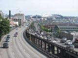
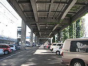
The Alaskan Way Viaduct, completed on April 4, 1953, is a double-decked elevated section of State Route 99
Washington State Route 99
State Route 99, abbreviated SR 99, commonly called Highway 99, is a numbered state highway in the U.S. state of Washington extending just under from Fife in the south to Everett in the north, with a gap in Tukwila.-Southern division:...
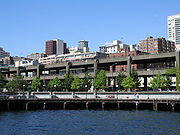
that runs along the Elliott Bay
Elliott Bay
Elliott Bay is the body of water on which Seattle, Washington, is located. A line drawn from Alki Point in the south to West Point in the north serves to mark the generally accepted division between the bay and the open sound...
waterfront in Seattle's Industrial District
Industrial District, Seattle, Washington
The Industrial District is the principal industrial area of Seattle, Washington. It is bounded on the west by the Duwamish Waterway and Elliott Bay, beyond which lies Delridge of West Seattle; on the east by Interstate 5, beyond which lies Beacon Hill; on the north by S King and S Dearborn Streets,...
and downtown Seattle
Downtown Seattle
Downtown is the central business district of Seattle, Washington. It is fairly compact compared to other city centers on the West Coast because of its geographical situation: hemmed in on the north and east by hills, on the west by the Elliott Bay, and on the south by reclaimed land that was once...
. It is the smaller of the two major north–south traffic corridors through Seattle (the other being Interstate 5
Interstate 5 in Washington
Interstate 5 in Washington is a highway in the U.S. state of Washington that extends from its border with Oregon to its border with Canada...
), carrying up to 110,000 vehicles per day. The viaduct
Viaduct
A viaduct is a bridge composed of several small spans. The term viaduct is derived from the Latin via for road and ducere to lead something. However, the Ancient Romans did not use that term per se; it is a modern derivation from an analogy with aqueduct. Like the Roman aqueducts, many early...
runs above the surface street, Alaskan Way
Alaskan Way
Alaskan Way, originally Railroad Avenue, is a street in Seattle, Washington, that runs along the Elliott Bay waterfront from just north of S. Holgate Street in the Industrial District—south of which it becomes East Marginal Way S.— to Broad Street in Belltown—north of which is Myrtle Edwards Park...
, from S. Nevada Street in the south to the entrance of Belltown's
Belltown, Seattle, Washington
Belltown is a neighborhood in Seattle, Washington, United States, in the 98121 Zip Code, located on the city's downtown waterfront, on land that was artificially flattened as part of a regrading project...
Battery Street Tunnel in the north, following previously existing railroad
Rail transport
Rail transport is a means of conveyance of passengers and goods by way of wheeled vehicles running on rail tracks. In contrast to road transport, where vehicles merely run on a prepared surface, rail vehicles are also directionally guided by the tracks they run on...
lines.
The viaduct was damaged in the 2001 Nisqually earthquake, and is proposed to be replaced
Proposed replacement of the Alaskan Way Viaduct
The Alaskan Way Viaduct is a viaduct bridge in the city of Seattle, Washington, that carries Washington State Route 99 over the Elliott Bay waterfront between the city's Industrial District and Belltown...
, in part by an underground tunnel running beneath the city's downtown core.
The initial phase of demolition and removal of the viaduct began on October 21, 2011.
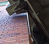
Earthquake concerns
The 1989 Loma Prieta earthquakeLoma Prieta earthquake
The Loma Prieta earthquake, also known as the Quake of '89 and the World Series Earthquake, was a major earthquake that struck the San Francisco Bay Area of California on October 17, 1989, at 5:04 p.m. local time...
destroyed the similarly designed Cypress Street Viaduct
Cypress Street Viaduct
The Cypress Street Viaduct, often referred to as the Cypress Structure, was a 1.6 mile long, raised two-tier, multi-lane freeway constructed of reinforced concrete that was originally part of the Nimitz Freeway in Oakland, California.It replaced an earlier single-deck viaduct constructed in the...
in Oakland, California
Oakland, California
Oakland is a major West Coast port city on San Francisco Bay in the U.S. state of California. It is the eighth-largest city in the state with a 2010 population of 390,724...
with considerable loss of life. The 2001 Nisqually earthquake
Nisqually earthquake
The Nisqually earthquake was an intraslab earthquake, occurring at 10:54 a.m. PST . on February 28, 2001, and was one of the largest recorded earthquakes in Washington state history. The quake measured 6.8 on the MMS and lasted approximately 45 seconds. The epicenter of the earthquake was Anderson...
damaged the viaduct and its supporting Alaskan Way Seawall
Alaskan Way Seawall
The Alaskan Way Seawall is a seawall which runs for along the Elliott Bay waterfront southwest of downtown Seattle from Bay Street to S. Washington Street. It was built to provide level access to Seattle's piers and supports the Alaskan Way Viaduct and Alaskan Way itself, which is a surface street...
and required the Washington State Department of Transportation
Washington State Department of Transportation
The Washington State Department of Transportation , was established in 1905. The agency, led by a Secretary and overseen by the Governor, is a Washington governmental agency that constructs, maintains, and regulates the use of the state's transportation infrastructure...
(WSDOT) to invest US$
United States dollar
The United States dollar , also referred to as the American dollar, is the official currency of the United States of America. It is divided into 100 smaller units called cents or pennies....
14.5 million in emergency repairs. Experts give a 1-in-20
Odds
The odds in favor of an event or a proposition are expressed as the ratio of a pair of integers, which is the ratio of the probability that an event will happen to the probability that it will not happen...
chance that the viaduct could be shut down by an earthquake
Earthquake
An earthquake is the result of a sudden release of energy in the Earth's crust that creates seismic waves. The seismicity, seismism or seismic activity of an area refers to the frequency, type and size of earthquakes experienced over a period of time...
within the next decade. Since the Nisqually Earthquake occurred, semi-annual inspections have discovered continuing settlement damage.
Proposed replacement
On January 12, 2009, the state of Washington, King CountyKing County, Washington
King County is a county located in the U.S. state of Washington. The population in the 2010 census was 1,931,249. King is the most populous county in Washington, and the 14th most populous in the United States....
, the city of Seattle, and the Port of Seattle
Port of Seattle
The Port of Seattle is a port district that runs Seattle's seaport and airport. Its creation was approved by the voters of King County, Washington, on September 5, 1911, authorized by the Port District Act. It is run by a five-member commission. The commissioners' terms run four years...
revealed that they had agreed to replace the viaduct with a four-lane, 2 miles (3.2 km) long underground tunnel. The tunnel would have a south portal in SoDo
SoDo, Seattle, Washington
SoDo is a neighborhood in Seattle, Washington, that makes up part of the city's Industrial District. It is bounded on the north by South King Street, beyond which is Pioneer Square; on the south by South Spokane Street, beyond which is more of the Industrial District; on the west by the Duwamish...
, near CenturyLink Field, and a north portal near Thomas Street, north of the Battery Street Tunnel.
The project is estimated to cost US$
United States dollar
The United States dollar , also referred to as the American dollar, is the official currency of the United States of America. It is divided into 100 smaller units called cents or pennies....
4.25 billion, with the state, city, and county promising funding well short of the estimate. The state will fund boring of the tunnels, while the city and county will fund surface street improvements and repairs to the Alaskan Way Seawall
Alaskan Way Seawall
The Alaskan Way Seawall is a seawall which runs for along the Elliott Bay waterfront southwest of downtown Seattle from Bay Street to S. Washington Street. It was built to provide level access to Seattle's piers and supports the Alaskan Way Viaduct and Alaskan Way itself, which is a surface street...
, which itself was damaged in the Nisqually earthquake. There is at present no publicly-known timetable for the construction and opening of the tunnel. Construction of the tunnel is scheduled to begin in early 2011 and end in late 2015, with the potential length of the project being 6 years.
The announcement did little to quell the long and heated debate over the viaduct's replacement, with several factions expressing their criticism over the tunnel decision.
Route description
First Avenue South Bridge
The First Avenue South Bridge is a pair of double-leaf bascule bridges built between 1956 and 1998 that carry State Route 99 over the Duwamish River about three miles south of downtown Seattle, Washington....
, passing over the west end of the Industrial District
Industrial District, Seattle, Washington
The Industrial District is the principal industrial area of Seattle, Washington. It is bounded on the west by the Duwamish Waterway and Elliott Bay, beyond which lies Delridge of West Seattle; on the east by Interstate 5, beyond which lies Beacon Hill; on the north by S King and S Dearborn Streets,...
. Just south of Safeco Field
Safeco Field
Safeco Field is a retractable roof baseball stadium located in Seattle, Washington. The stadium, owned and operated by the Washington-King County Stadium Authority, is the home stadium of the Seattle Mariners of Major League Baseball and has a seating capacity of 47,878 for baseball...
, at Massachusetts Street, the bridge shifts from a side-by-side alignment to the double-deck alignment commonly associated with the Alaskan Way Viaduct, with northbound traffic on the upper deck and southbound traffic on the lower deck. Then, at approximately Pike Street, the bridge reverts to a side-by-side alignment for about ½ mile until the viaduct's north end at the entrance to the Battery Street Tunnel.
Entrances and exits
| Mile | Entrances | Exits | Destinations |
|---|---|---|---|
| 28.91 | southbound | northbound | Spokane Street - West Seattle West Seattle, Seattle, Washington West Seattle comprises two of Seattle, Washington's thirteen districts, Delridge and Southwest and encompasses all of Seattle west of the Duwamish River. It was incorporated as an independent town in 1902 and was annexed by Seattle in 1907. Among the area's attractions are its saltwater beach parks... |
| 28.91 | northbound | southbound | West Seattle Bridge West Seattle Bridge The high-level West Seattle Bridge is a cantilevered segmental bridge that serves as the primary connection between West Seattle and the rest of the city. It was built between 1981 and 1984 after the previous bascule bridge was deemed inoperable as a result of being struck by the Chavez freighter... /Harbor Island Harbor Island Harbor Island is an artificial island in the mouth of Seattle, Washington's Duwamish Waterway where it empties into Elliott Bay. Built by the Puget Sound Bridge and Dredging Company, Harbor Island was completed in 1909 and was then the largest artificial island in the world, at 350 acres... |
| 30.75 | northbound Closed until 04/01/2011 |
southbound | 1st Avenue S./Safeco Field Safeco Field Safeco Field is a retractable roof baseball stadium located in Seattle, Washington. The stadium, owned and operated by the Washington-King County Stadium Authority, is the home stadium of the Seattle Mariners of Major League Baseball and has a seating capacity of 47,878 for baseball... /Qwest Field Qwest Field CenturyLink Field is a multi-purpose stadium in Seattle, Washington, United States. It serves as the home field for the Seattle Seahawks of the National Football League and Seattle Sounders FC of Major League Soccer... /Colman Dock Washington State Ferries Washington State Ferries is a passenger and automobile ferry service owned and operated by the Washington State Department of Transportation that serves communities on Puget Sound and in the San Juan Islands. It is the most used ferry system in the world and the largest passenger and automobile... |
| 31.30 | southbound | northbound | Seneca Street/Downtown Downtown Seattle Downtown is the central business district of Seattle, Washington. It is fairly compact compared to other city centers on the West Coast because of its geographical situation: hemmed in on the north and east by hills, on the west by the Elliott Bay, and on the south by reclaimed land that was once... |
| 31.95 | northbound and southbound | northbound and southbound | Western Avenue/Belltown Belltown, Seattle, Washington Belltown is a neighborhood in Seattle, Washington, United States, in the 98121 Zip Code, located on the city's downtown waterfront, on land that was artificially flattened as part of a regrading project... |
| 32.44 | northbound | southbound | Denny Way/South Lake Union South Lake Union, Seattle, Washington South Lake Union is a neighborhood in Seattle, Washington, so named because it is at the south tip of Lake Union.The official boundaries of the City of Seattle Urban Center are Denny Way on the south, beyond which is Denny Triangle; Interstate 5 on the east, beyond which is Capitol Hill; Aurora... |
See also
- Gardiner ExpresswayGardiner ExpresswayThe Frederick G. Gardiner Expressway, colloquially referred to as "the Gardiner", is a municipal expressway in the Canadian province of Ontario, connecting downtown Toronto with its western suburbs...
(an elevated freeway in TorontoTorontoToronto is the provincial capital of Ontario and the largest city in Canada. It is located in Southern Ontario on the northwestern shore of Lake Ontario. A relatively modern city, Toronto's history dates back to the late-18th century, when its land was first purchased by the British monarchy from...
with similar future plans)
External links
- SR 99 - Alaskan Way Viaduct & Seawall Replacement Project
- Alaskan Way Viaduct, Part 1: Early Transportation Planning
- Alaskan Way Viaduct, Part 2: Planning and Design
News stories
-
- note: article links to videos which require RealPlayerRealPlayerRealPlayer is a cross-platform media player by RealNetworks that plays a number of multimedia formats including MP3, MPEG-4, QuickTime, Windows Media, and multiple versions of proprietary RealAudio and RealVideo formats.-History:...
10.5
- note: article links to videos which require RealPlayer