

Belmont County, Ohio
Encyclopedia
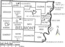
Belmont County is a county located in the U.S. state
of Ohio
. It is part of the Wheeling, West Virginia
Metropolitan Statistical Area
. As of 2010, the population was 70,400. http://quickfacts.census.gov/qfd/states/39/39013.html Its county seat
is St. Clairsville
. The county takes its name from the French
for "beautiful mountain".
In 1987, Michael A Massa, a county resident, created and dedicated the County's first Official Seal and Flag
to the people of Belmont County (photo of county seal featured above the county map- see vignette at above right). The citizens of the county held an informal election to select the winning seal and flag, and the event was featured nationally on the Paul Harvey Show.
, the county has a total area of 541 square miles (1,401.2 km²), of which 537 square miles (1,390.8 km²) is land and 4 square miles (10.4 km²) (0.75%) is water.
of 2000, there were 70,226 people, 28,309 households, and 19,250 families residing in the county. The population density
was 131 people per square mile (50/km²). There were 31,236 housing units at an average density of 58 per square mile (22/km²). The racial makeup of the county was 94.98% White
, 3.64% Black
or African American
, 0.14% Native American
, 0.30% Asian
, 0.02% Pacific Islander
, 0.16% from other races
, and 0.77% from two or more races. 0.39% of the population were Hispanic
or Latino
of any race. 20.2% were of German
, 12.5% Irish
, 12.0% American
, 10.3% English
, 10.2% Italian and 9.0% Polish
ancestry according to Census 2000.
There were 28,309 households out of which 28.30% had children under the age of 18 living with them, 53.10% were married couples
living together, 11.20% had a female householder with no husband present, and 32.00% were non-families. 28.70% of all households were made up of individuals and 15.10% had someone living alone who was 65 years of age or older. The average household size was 2.37 and the average family size was 2.90.
In the county the population was spread out with 21.80% under the age of 18, 7.70% from 18 to 24, 27.40% from 25 to 44, 24.90% from 45 to 64, and 18.20% who were 65 years of age or older. The median age was 41 years. For every 100 females there were 96.40 males. For every 100 females age 18 and over, there were 93.60 males.
The median income for a household in the county was $29,714, and the median income for a family was $37,538. Males had a median income of $31,211 versus $19,890 for females. The per capita income
for the county was $16,221. About 11.70% of families and 14.60% of the population were below the poverty line, including 20.40% of those under age 18 and 9.80% of those age 65 or over.
Belmont County's county flag was designed in 1988 by local state official Michael Massa. Local citizens voted in a nationally-covered election to choose it from a group of three designs by Massa. The seal (minus a Latin phrase) is featured on the county's flag.
. The Belmont Correctional Institution is located on 158 acre (0.63940388 km²) between St. Clairsville and Warnock
on State Route 331
. The facility currently houses 2,698 inmates. The Belmont County Jail is located in St. Clairsville and is located near Belmont Technical College and Ohio University Eastern Campus. The facility contains 72 beds and also houses the county sheriff's offices. The county is also serviced by Sargus Juvenile Detention Center
, a 17 bed facility that also services surrounding counties. Sargus Center is located next door to the county jail.
A small part of the county is served by the following schools of the multicounty Switzerland of Ohio Local School District
:
U.S. state
A U.S. state is any one of the 50 federated states of the United States of America that share sovereignty with the federal government. Because of this shared sovereignty, an American is a citizen both of the federal entity and of his or her state of domicile. Four states use the official title of...
of Ohio
Ohio
Ohio is a Midwestern state in the United States. The 34th largest state by area in the U.S.,it is the 7th‑most populous with over 11.5 million residents, containing several major American cities and seven metropolitan areas with populations of 500,000 or more.The state's capital is Columbus...
. It is part of the Wheeling, West Virginia
Wheeling, West Virginia
Wheeling is a city in Ohio and Marshall counties in the U.S. state of West Virginia; it is the county seat of Ohio County. Wheeling is the principal city of the Wheeling Metropolitan Statistical Area...
Metropolitan Statistical Area
Wheeling metropolitan area
The Wheeling Metropolitan Statistical Area, as defined by the United States Census Bureau, is an area consisting of two counties in the Northern Panhandle of West Virginia and one in Ohio, anchored by the city of Wheeling...
. As of 2010, the population was 70,400. http://quickfacts.census.gov/qfd/states/39/39013.html Its county seat
County seat
A county seat is an administrative center, or seat of government, for a county or civil parish. The term is primarily used in the United States....
is St. Clairsville
St. Clairsville, Ohio
St. Clairsville is a city in Belmont County, Ohio in the United States. It is part of the Wheeling, West Virginia Metropolitan Statistical Area. The population was 5,057 at the 2000 census. This county seat of Belmont County has been nicknamed "Paradise on the Hill." St. Clairsville was named after...
. The county takes its name from the French
French language
French is a Romance language spoken as a first language in France, the Romandy region in Switzerland, Wallonia and Brussels in Belgium, Monaco, the regions of Quebec and Acadia in Canada, and by various communities elsewhere. Second-language speakers of French are distributed throughout many parts...
for "beautiful mountain".
History
In 1976, Belmont County became the first American county to elect a female sheriff, Katherine Crumbly.http://www.belmontsheriff.com/history.htmlIn 1987, Michael A Massa, a county resident, created and dedicated the County's first Official Seal and Flag
to the people of Belmont County (photo of county seal featured above the county map- see vignette at above right). The citizens of the county held an informal election to select the winning seal and flag, and the event was featured nationally on the Paul Harvey Show.
Geography
According to the U.S. Census BureauUnited States Census Bureau
The United States Census Bureau is the government agency that is responsible for the United States Census. It also gathers other national demographic and economic data...
, the county has a total area of 541 square miles (1,401.2 km²), of which 537 square miles (1,390.8 km²) is land and 4 square miles (10.4 km²) (0.75%) is water.
Adjacent counties
- Harrison County (north)
- Jefferson CountyJefferson County, OhioJefferson County is a county located in the state of Ohio. As of 2010, the population was 69,709. Its county seat is Steubenville and is named for Thomas Jefferson, who was at the time Vice President....
(northeast) - Ohio County, West VirginiaOhio County, West VirginiaAs of the census of 2000, there were 47,427 people, 19,733 households, and 12,155 families residing in the county. The population density was 447 people per square mile . There were 22,166 housing units at an average density of 209 per square mile...
(east) - Marshall County, West VirginiaMarshall County, West VirginiaAs of the census of 2000, there were 35,519 people, 14,207 households, and 10,101 families residing in the county. The population density was 116 people per square mile . There were 15,814 housing units at an average density of 52 per square mile...
(southeast) - Monroe CountyMonroe County, OhioMonroe County is a county located in the state of Ohio. As of the 2010 census, the population was 14,642. Its county seat is Woodsfield and is named for James Monroe, Secretary of State when the county was formed and later President of the United States....
(south) - Noble CountyNoble County, OhioNoble County is a county located in the state of Ohio. As of the 2010 census, the population was 14,645. Its county seat is Caldwell. Noble County is named for Rep. Warren P. Noble of the Ohio House of Representatives, who was an early settler there.-History:...
(southwest) - Guernsey CountyGuernsey County, OhioGuernsey County is a county located in the state of Ohio. As of 2010, the population was 40,087. Its county seat is Cambridge and is named for the Isle of Guernsey in the English Channel, from which many of the county's early settlers came....
(west)
Demographics
As of the censusCensus
A census is the procedure of systematically acquiring and recording information about the members of a given population. It is a regularly occurring and official count of a particular population. The term is used mostly in connection with national population and housing censuses; other common...
of 2000, there were 70,226 people, 28,309 households, and 19,250 families residing in the county. The population density
Population density
Population density is a measurement of population per unit area or unit volume. It is frequently applied to living organisms, and particularly to humans...
was 131 people per square mile (50/km²). There were 31,236 housing units at an average density of 58 per square mile (22/km²). The racial makeup of the county was 94.98% White
Race (United States Census)
Race and ethnicity in the United States Census, as defined by the Federal Office of Management and Budget and the United States Census Bureau, are self-identification data items in which residents choose the race or races with which they most closely identify, and indicate whether or not they are...
, 3.64% Black
Race (United States Census)
Race and ethnicity in the United States Census, as defined by the Federal Office of Management and Budget and the United States Census Bureau, are self-identification data items in which residents choose the race or races with which they most closely identify, and indicate whether or not they are...
or African American
Race (United States Census)
Race and ethnicity in the United States Census, as defined by the Federal Office of Management and Budget and the United States Census Bureau, are self-identification data items in which residents choose the race or races with which they most closely identify, and indicate whether or not they are...
, 0.14% Native American
Race (United States Census)
Race and ethnicity in the United States Census, as defined by the Federal Office of Management and Budget and the United States Census Bureau, are self-identification data items in which residents choose the race or races with which they most closely identify, and indicate whether or not they are...
, 0.30% Asian
Race (United States Census)
Race and ethnicity in the United States Census, as defined by the Federal Office of Management and Budget and the United States Census Bureau, are self-identification data items in which residents choose the race or races with which they most closely identify, and indicate whether or not they are...
, 0.02% Pacific Islander
Race (United States Census)
Race and ethnicity in the United States Census, as defined by the Federal Office of Management and Budget and the United States Census Bureau, are self-identification data items in which residents choose the race or races with which they most closely identify, and indicate whether or not they are...
, 0.16% from other races
Race (United States Census)
Race and ethnicity in the United States Census, as defined by the Federal Office of Management and Budget and the United States Census Bureau, are self-identification data items in which residents choose the race or races with which they most closely identify, and indicate whether or not they are...
, and 0.77% from two or more races. 0.39% of the population were Hispanic
Race (United States Census)
Race and ethnicity in the United States Census, as defined by the Federal Office of Management and Budget and the United States Census Bureau, are self-identification data items in which residents choose the race or races with which they most closely identify, and indicate whether or not they are...
or Latino
Race (United States Census)
Race and ethnicity in the United States Census, as defined by the Federal Office of Management and Budget and the United States Census Bureau, are self-identification data items in which residents choose the race or races with which they most closely identify, and indicate whether or not they are...
of any race. 20.2% were of German
Germans
The Germans are a Germanic ethnic group native to Central Europe. The English term Germans has referred to the German-speaking population of the Holy Roman Empire since the Late Middle Ages....
, 12.5% Irish
Irish people
The Irish people are an ethnic group who originate in Ireland, an island in northwestern Europe. Ireland has been populated for around 9,000 years , with the Irish people's earliest ancestors recorded having legends of being descended from groups such as the Nemedians, Fomorians, Fir Bolg, Tuatha...
, 12.0% American
United States
The United States of America is a federal constitutional republic comprising fifty states and a federal district...
, 10.3% English
English people
The English are a nation and ethnic group native to England, who speak English. The English identity is of early mediaeval origin, when they were known in Old English as the Anglecynn. England is now a country of the United Kingdom, and the majority of English people in England are British Citizens...
, 10.2% Italian and 9.0% Polish
Poles
thumb|right|180px|The state flag of [[Poland]] as used by Polish government and diplomatic authoritiesThe Polish people, or Poles , are a nation indigenous to Poland. They are united by the Polish language, which belongs to the historical Lechitic subgroup of West Slavic languages of Central Europe...
ancestry according to Census 2000.
There were 28,309 households out of which 28.30% had children under the age of 18 living with them, 53.10% were married couples
Marriage
Marriage is a social union or legal contract between people that creates kinship. It is an institution in which interpersonal relationships, usually intimate and sexual, are acknowledged in a variety of ways, depending on the culture or subculture in which it is found...
living together, 11.20% had a female householder with no husband present, and 32.00% were non-families. 28.70% of all households were made up of individuals and 15.10% had someone living alone who was 65 years of age or older. The average household size was 2.37 and the average family size was 2.90.
In the county the population was spread out with 21.80% under the age of 18, 7.70% from 18 to 24, 27.40% from 25 to 44, 24.90% from 45 to 64, and 18.20% who were 65 years of age or older. The median age was 41 years. For every 100 females there were 96.40 males. For every 100 females age 18 and over, there were 93.60 males.
The median income for a household in the county was $29,714, and the median income for a family was $37,538. Males had a median income of $31,211 versus $19,890 for females. The per capita income
Per capita income
Per capita income or income per person is a measure of mean income within an economic aggregate, such as a country or city. It is calculated by taking a measure of all sources of income in the aggregate and dividing it by the total population...
for the county was $16,221. About 11.70% of families and 14.60% of the population were below the poverty line, including 20.40% of those under age 18 and 9.80% of those age 65 or over.
Government
Almost all of the county's government offices are located in the Belmont County Courthouse.Belmont County's county flag was designed in 1988 by local state official Michael Massa. Local citizens voted in a nationally-covered election to choose it from a group of three designs by Massa. The seal (minus a Latin phrase) is featured on the county's flag.
Corrections
Belmont County is serviced by several detentional centers located around St. ClairsvilleSt. Clairsville, Ohio
St. Clairsville is a city in Belmont County, Ohio in the United States. It is part of the Wheeling, West Virginia Metropolitan Statistical Area. The population was 5,057 at the 2000 census. This county seat of Belmont County has been nicknamed "Paradise on the Hill." St. Clairsville was named after...
. The Belmont Correctional Institution is located on 158 acre (0.63940388 km²) between St. Clairsville and Warnock
Warnock, Ohio
Warnock is an unincorporated community in northern Smith Township, Belmont County, Ohio, United States. Although it is unincorporated, it has a post office, with the ZIP code of 43967. It lies along State Route 9....
on State Route 331
Ohio State Route 331
State Route 331 is an east–west state highway in the eastern portion of the U.S. state of Ohio. State Route 331 has its western terminus at U.S. Route 22 approximately northwest of the village of Holloway. Its eastern terminus is at a signalized intersection with U.S...
. The facility currently houses 2,698 inmates. The Belmont County Jail is located in St. Clairsville and is located near Belmont Technical College and Ohio University Eastern Campus. The facility contains 72 beds and also houses the county sheriff's offices. The county is also serviced by Sargus Juvenile Detention Center
Sargus Juvenile Detention Center
Established in 1973, Sargus Juvenile Detention Center is one of seven juvenile detention centers in the U.S. state of Ohio. Named after Judge Edmund A. Sargus, a former juvenile court judge of Belmont County, it is located just outside St. Clairsville, Ohio...
, a 17 bed facility that also services surrounding counties. Sargus Center is located next door to the county jail.
Communities
Villages
|
Bridgeport, Ohio Bridgeport is a village in Belmont County, Ohio, United States. It is part of the Wheeling, West Virginia Metropolitan Statistical Area. The population was 1,831 at the 2010 census... Brookside, Ohio Brookside is a village in Belmont County, Ohio, United States. It is part of the Wheeling, West Virginia Metropolitan Statistical Area. The population was 644 at the 2000 census.-Geography:Brookside is located at .... Fairview, Ohio Fairview is a village in Belmont and Guernsey counties in the U.S. state of Ohio. It is part of the Wheeling, West Virginia Metropolitan Statistical Area... Flushing, Ohio Flushing is a village in Belmont County, Ohio, United States. It is part of the Wheeling, West Virginia Metropolitan Statistical Area. The population was 900 at the 2000 census.-Geography:Flushing is located at .... |
Holloway, Ohio Holloway is a village in Belmont County, Ohio, United States. It is part of the Wheeling, West Virginia Metropolitan Statistical Area. The population was 345 at the 2000 census.-Geography:Holloway is located at .... Morristown, Ohio Morristown is a village in Belmont County, Ohio, United States. It is part of the Wheeling, West Virginia Metropolitan Statistical Area. The population was 299 at the 2000 census.-History:The community's name has also been spelled "Morris Town" in the past.... Powhatan Point, Ohio Powhatan Point is one of several small villages in Belmont County, Ohio, United States, along the Ohio River. The population was 1,744 at the 2000 census... |
Shadyside, Ohio Shadyside is a village in Belmont County, Ohio, United States, along the Ohio River. It is part of the Wheeling, West Virginia Metropolitan Statistical Area... Wilson, Ohio Wilson is a village in Belmont and Monroe counties in the US State of Ohio. It is part of the Wheeling, West Virginia Metropolitan Statistical Area... Yorkville, Ohio Yorkville is a village in Belmont and Jefferson counties in the U.S. state of Ohio. The population was 1,230 at the 2000 census.Yorkville lies within two Metropolitan Statistical Areas – the Belmont County portion is part of the Wheeling metropolitan area, while the Jefferson County portion... |
Townships
|
Mead Township, Belmont County, Ohio Mead Township is one of the sixteen townships of Belmont County, Ohio, United States. The 2000 census found 6,023 people in the township, 2,405 of whom lived in the unincorporated portions of the township.-Geography:... Pease Township, Belmont County, Ohio Pease Township is one of the sixteen townships of Belmont County, Ohio, United States. The 2000 census found 14,961 people in the township, 4,367 of whom lived in the unincorporated portions of the township.-Geography:... Pultney Township, Belmont County, Ohio Pultney Township is one of the sixteen townships of Belmont County, Ohio, United States. The 2000 census found 9,700 people in the township, 4,751 of whom lived in the unincorporated portions of the township.-Geography:... Richland Township, Belmont County, Ohio Richland Township is one of the sixteen townships of Belmont County, Ohio, United States. The 2000 census found 13,571 people in the township, 8,514 of whom lived in the unincorporated portions of the township.-Geography:... |
Smith Township, Belmont County, Ohio Smith Township is one of the sixteen townships of Belmont County, Ohio, United States. The 2000 census found 1,445 people in the township.-Geography:Located in the central part of the county, it borders the following townships:*Richland Township - north... Somerset Township, Belmont County, Ohio Somerset Township is one of the sixteen townships of Belmont County, Ohio, United States. The 2000 census found 1,186 people in the township.-Geography:Located in the southwestern corner of the county, it borders the following townships:... Union Township, Belmont County, Ohio Union Township is one of the sixteen townships of Belmont County, Ohio, United States. The 2000 census found 2,151 people in the township, 1,852 of whom lived in the unincorporated portions of the township.-Geography:... Warren Township, Belmont County, Ohio Warren Township is one of the sixteen townships of Belmont County, Ohio, United States. The 2000 census found 5,870 people in the township, 1,645 of whom lived in the unincorporated portions of the township.-Geography:... |
Washington Township, Belmont County, Ohio Washington Township is one of the sixteen townships of Belmont County, Ohio, United States. The 2000 census found 537 people in the township.-Geography:Located in the southern part of the county, it borders the following townships:*Smith Township - north... Wayne Township, Belmont County, Ohio Wayne Township is one of the sixteen townships of Belmont County, Ohio, United States. The 2000 census found 624 people in the township, 587 of whom lived in the unincorporated portions of the township.-Geography:... Wheeling Township, Belmont County, Ohio Wheeling Township is one of the sixteen townships of Belmont County, Ohio, United States. The 2000 census found 1,477 people in the township.-Geography:Located in the northern part of the county, it borders the following townships:... York Township, Belmont County, Ohio York Township is one of the sixteen townships of Belmont County, Ohio, United States. The 2000 census found 2,648 people in the township, 904 of whom lived in the unincorporated portions of the township.-Geography:... |
Unincorporated communities
|
Colerain, Ohio Colerain is an unincorporated community in eastern Colerain Township, Belmont County, Ohio, United States. Although it is unincorporated, it has a post office, with the ZIP code of 43916. It lies along U.S. Route 250.... Fairpoint, Ohio Fairpoint is an unincorporated community in eastern Wheeling Township, Belmont County, Ohio, United States, along Wheeling Creek. Although it is unincorporated, it has a post office, with the ZIP code of 43927. It lies along State Route 9.... Glencoe, Ohio Glencoe is a census-designated place in southern Richland Township, Belmont County, Ohio, United States. Although it is unincorporated, it has a post office, with the ZIP code of 43928.Glencoe is part of the Wheeling, WV-OH Metropolitan Statistical Area.... |
Jacobsburg, Ohio Jacobsburg is an unincorporated community in southeastern Smith Township, Belmont County, Ohio, United States. Although it is unincorporated, it has a post office, with the ZIP code of 43933. It lies along State Route 147.... Lafferty, Ohio Lafferty is a census-designated place in northeastern Union Township, Belmont County, Ohio, United States, along Wheeling Creek. Although it is unincorporated, it has a post office, with the ZIP code of 43951... Lansing, Ohio Lansing is a census-designated place in northern Pultney Township, Belmont County, Ohio, United States, along Wheeling Creek. Although it is unincorporated, it has a post office, with the ZIP code of 43934.... Maynard, Ohio Maynard is an unincorporated community in western Colerain Township, Belmont County, Ohio, United States, along Wheeling Creek. Although it is unincorporated, it has a post office, with the ZIP code of 43937.... |
Riverview, Belmont County, Ohio Riverview is an unincorporated area along State Route 7 in southeastern Pease Township, Belmont County, Ohio, United States, between Martins Ferry and Bellaire. At one time, Riverview was a small unincorporated village, but it was mostly demolished to make way for part of Interstate 470 near its... Warnock, Ohio Warnock is an unincorporated community in northern Smith Township, Belmont County, Ohio, United States. Although it is unincorporated, it has a post office, with the ZIP code of 43967. It lies along State Route 9.... |
K-12
Belmont County is served by the following local school districts- Barnesville Exempted Village School DistrictBarnesville Exempted Village School DistrictBarnesville Exempted Village Schools serves the village of Barnesville, Ohio, USA, and the surrounding area.-Board of education:*President Richard Pryor*Vice President Scott Baker*Member Don Carpenter*Member Marilyn Lucas*Member Rob Miller...
- Bellaire Local
- Belmont County Educational Service Center
- Bridgeport Exempted Village
- Martins Ferry City
- Olney Friends SchoolOlney Friends SchoolOlney Friends School is a small, co-educational boarding high school affiliated with the Religious Society of Friends . Located in the foothills of the Appalachian Mountains in Barnesville, Ohio, the school "challenges students to grow, celebrates intellectual vigor, provokes questions of...
- Shadyside Local
- St. Clairsville-Richland City
- Union Local High SchoolUnion Local High School (Belmont, Ohio)Union Local High School is a public high school in Belmont, Ohio. It is the only high school in the Union Local School District.-Athletics:The school's sports teams are known as the Jets...
A small part of the county is served by the following schools of the multicounty Switzerland of Ohio Local School District
Switzerland of Ohio Local School District
The Switzerland Of Ohio Local School District is a rural school district located in southeastern Ohio that covers all of Monroe County and part of Belmont County and Noble County...
:
- Hannibal Elementary School in HannibalHannibal, OhioHannibal is a census-designated place in eastern Ohio Township, Monroe County, Ohio, United States. Although it is unincorporated, it has a post office, with the ZIP code of 43931. It lies along State Route 7....
- Powhatan Elementary School in Powhatan PointPowhatan Point, OhioPowhatan Point is one of several small villages in Belmont County, Ohio, United States, along the Ohio River. The population was 1,744 at the 2000 census...
- River High School in HannibalHannibal, OhioHannibal is a census-designated place in eastern Ohio Township, Monroe County, Ohio, United States. Although it is unincorporated, it has a post office, with the ZIP code of 43931. It lies along State Route 7....
Higher education
- Belmont Technical CollegeBelmont Technical CollegeBelmont Technical College is a two year public college, main campus is located west of St. Clairsville, Ohio on National Road. The college was founded in 1971 and has served the Ohio Valley communities for over 30 years....
- Ohio UniversityOhio UniversityOhio University is a public university located in the Midwestern United States in Athens, Ohio, situated on an campus...
Eastern CampusOhio University Eastern CampusOhio University Eastern Campus is a two to four year public university located west of St. Clairsville, Ohio on National Road. The university first opened its doors in 1957 and has served the Ohio River Valley communities for over 50 years....