

Mystic, Connecticut
Encyclopedia
Mystic is a village and census-designated place
(CDP) in New London County
, Connecticut
, in the United States
. The population was 4,001 at the 2000 census. A historic locality, Mystic has no independent government because it is not a legally recognized municipality in the state of Connecticut. Rather, Mystic is located within the towns of Groton
(west of the Mystic River, and also known as West Mystic) and Stonington
(east of the Mystic River).
Historically a leading seaport of the area, the story of Mystic's nautical connection is told at Mystic Seaport
, the nation's largest maritime museum
, which has preserved a number of sailing ship
s (most notably the whaleship
Charles W. Morgan
) and seaport buildings. The village is located on the Mystic River
, which flows into Long Island Sound
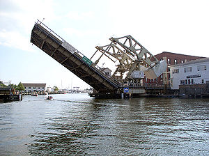
, providing access to the sea. The Mystic River Bascule Bridge
crosses the river in the center of the village.
had established an empire across southeastern Connecticut
. For many years, historians believed that they migrated in the 16th century from eastern New York. Archaeological evidence showing the presence of a people who lived in an area called Gungywump, somewhat northwest of the Mystic River
, now suggests that the Pequot were indigenous to southeastern Connecticut.
The Pequot built their first village overlooking the western bank of the Mystic River, called Siccanemos, in the year 1665. By that time, the Pequot were in control of a considerable amount of territory, extending toward the Pawcatuck River
to the east and the Connecticut River
to the west, providing them with full access to the waters. They also had supremacy over some of the most strategically located terrain. To the northwest, the Five Nations of the Iroquois
dominated the land linked by the Great Lakes
and the Hudson River
, allowing for trading to occur between the Iroquois Nations and the Dutch
. The Pequot were settled just distant enough to be secure from any danger that the Iroquois posed.
to Nova Scotia
, they brought along with them diseases, such as small pox, plague, measles
and other illnesses that depopulated entire villages, killing between 55 to 95 percent of coastal people. The Narragansett
tribe, who lived a considerable distance from the coast, were able to develop some resistance to European diseases, or the diseases evolved lower virulence
as they were transmitted inland.
The Pequot were located between the English
and the Dutch
. To the east of the Pequot, the English had begun to gain bits and pieces along the Massachusetts Bay
during the 1620s. Relations between the Native Americans and the English remained ambiguous and rather hostile at times as Separatists from the Church of England
settled on the Plymouth Plantation
. Their relations, however, allowed the establishment of trade with the Plymouth colonists as far west as the Narragansett Bay
, if not with the Narragansett nation itself. The English eventually began to trade with the Dutch as well.
In 1632, the Dutch established Good Hope, depriving the Pequot of a monopoly
at the post; they brought in interlopers to the Pequot territory whom they could not control, raising apprehension among the two villages. This destabilized the Pequot’s control of fur and wampum
sources. In 1634, just when the Massachusetts Bay post made its first public appearance, hostilities escalated between the Pequot and Narragansett tribes.
In revenge of this attack, the Dutch captured and seized Tatobem, Pequot’s uppermost chief and held him at ransom
to be paid in wampum. The ransom was paid immediately, but Tatobem was executed anyway. The murder of Tatobem further escalated aggression between the Pequot nation and Massachusetts Bay; they retaliated by killing an English man, John Stone], at the Connecticut River
. There are many assumptions to why Stone was chosen in retribution. Historians say that while trading on shore, Stone kidnapped
a handful of Pequot, with intentions to sell them into slavery, and was beaten and slaughtered by their rescuers.
Exasperated by this news the Massachusetts Bay
management interpreted the murder of Stone as a declaration of war. In October 1634, Pequot delegates took a trip to Massachusetts Bay
to guarantee the colonists that they had not intended nor planned to go to war with the English. They took full blame for Stone’s death, and offered Governor Roger Ludlow
payment for his death. The Massachusetts Bay colonists refused to accept the payment as justice for Stone’s death.
As an alternative, the Massachusetts Bay government took the chance to expand their claims in New England. “They demanded that Stone’s killer be handed over to meet European justice, that a ransom in wampum worth 250 pounds sterling be paid; that the Pequot cede all of their land to the Massachusetts Bay Colony
; that the Pequot only trade with the English; and that all disputes between the Pequot and the Narragansett be mediated by the English. The Pequot delegation seemed to agree to the settlement and returned home, but Tatobem’s successor, Sassacus
, rejected and thereby nullified the agreement.”
With the death of Tatobem, and the rise of Sassacus, two factions formed, both declaring Tatobem’s position: Tatobem’s son, Sassacus, and Tatobem’s son-in-law, Uncas
. When Sassacus emerged victorious, Uncas left the tribe and became Sachem
of villages around the Niantic River
, calling themselves the Mohegan.
Tensions increased between the factions of Indians, especially towards the Pequot. The 1636, John Oldham, a respected trader and friend of the Narragansetts, was murdered in his boat off Block Island
. The murderers were Block Islanders, a branch of Narragansetts, however, they escaped capture and were given safe haven by the Pequots. This outraged the Narragansetts.
In May of 1637, captains John Underhill and John Mason led a retaliatory mission through Narragansett land along with their allies, the Narragansett and Mohegan, and struck the Pequot settlement in Mystic. Uncas and Wequash also joined the fight, bringing seventy of his own men. The settlement, mostly of women and children, was decimated. Mason set fire to eighty homes, killing 600-700 Pequot in an hour. Seven were taken captive and seven escaped. Two Englishmen were killed, while 20-40 were wounded.
 Captain John Underhill, one of the English commanders, documents the event in his journal, Newes from America:
The Treaty of Hartford
was drawn up stating the terms of the English victory. On September 21, 1638, the colonists signed the Treaty of Hartford, officially ending the Pequot War. It outlawed the name Pequot, forbid the Pequot from regrouping as a tribe, and required that other tribes in the region submit all their inter-tribal grievances to the English and abide by their decisions. Gradually, with the help of sympathetic English leaders, the Pequot were able to reestablish their identity, but as separate tribes in separate communities: the Mashantucket (Western) Pequot
and the Paucatuck (Eastern) Pequot, the first Indian reservations in America.
Settlement grew slowly. With the removal of the Pequot, the Narragansett, led by Miantonomo, claimed the former Pequot territory, which the colonists had also claimed. While the colonists allegedly owned the territory by rights of conquest, they continued to consult with the native villages to purchase the land. The Narragansett and Mohegan nations had conflicting views on the issue that war broke out between the two, resulting in Miantonomo’s death and the Mohegan’s victory.
The Connecticut government
and Massachusetts Bay government began to quarrel about land, thus delaying the migration process of English families to the Mystic River. “Connecticut,” referred to, in the 1640s and 1650s, settlements located along the Connecticut River as well as its claims in other parts of the region. Many groups of people may have claimed the same land as rightfully theirs. However when settlers were being brought to the disputed territory, conflict arose.
Since Connecticut did not have a royal charter that separated it from the Massachusetts Bay Colony, it had created their own government to meet the calamities that followed the Pequot War, and was preserved to handle affairs including land distribution and grants. The General Court was formed by leaders of the settlements, which addressed the problem against the Pequot.
The General court ruled the Pequot land by right of conquest, in order to pay the Connecticut veterans of the war. The Bay Colony however saw matters differently. The Bay Colony had contributed to the war by sending a militia under Captains John Underhill and Thomas Stoughton, which would enable them territorial rights. On top of that, the Massachusetts Bay legally claimed Connecticut as their territory, and the right to freely distribute the conquered Pequot land. This made John Winthrop Jr.’s Pequot Plantation answerable to the Massachusetts Bay Colony opposed to the Connecticut Court.
With conflicting views, both colonies turned to the United Colonies of New England to resolve the dispute. The United Colonies of New England, formed in 1643, was established in order to settle the disputes such as this one. It was voted to create the boundary between the claims of the Massachusetts Bay and Connecticut at the Thames River
. As a result, Connecticut would be positioned west of the river and Massachusetts Bay could have the land to the east, including the Mystic River.
Throughout the next decade, settlers were beginning to emerge around the Mystic River. John Mason, one of the captains who led the colonists against the Pequot, had previously been granted 500 acres (2 km²) on the eastern banks of the Mystic River. He also received the island that later bore his name, however, he never lived on the property. In 1653, John Gallup Jr., was given 300 acres (1.2 km²) approximately midway up the east part of the Mystic River.
Within the same year, other settlers joined John Gallup and began to settle around the Mystic River. George Denison, a war veteran of Oliver Cromwell
’s army, was given his own strip of 300 acres (1.2 km²), just south of Gallup’s land in 1654. Thomas Miner, who had immigrated to Massachusetts with John Winthrop, was granted many land plots, the main one lying on Quiambaug Cove, just east of the Mystic River. Other families granted land at their arrival were Reverend Robert Blinman, the Beebe brothers, Thomas Parke and Connecticut Governor John Hayne.
Like Captain John Mason, not all these men actually lived on their land. Many sold it to profit from or employed an overseer to cultivate their property. Many men, however, actually brought their wives and children which indicated their plans on forming a community in the Mystic River Valley.
There was one recorded case of a woman who did not come to the Mystic River Valley as a wife. Margaret Lake, a widow, received a grant from the Massachusetts Bay authority, and was the only woman to receive a land grant in her own name. Margaret Lake, like many men in her day, also did not live on her land, and hired other people to maintain her property. She end up taking up residence in the Pequot Plantation. Lake’s daughter was married to John Gallup, while her sister was married to John Winthrop, Massachusetts Bay Governor.
As settlers made the move to the conquered land of the Pequot, the Native American population deceased drastically. Nearly all tribes were hit with rampant epidemics, and fur-bearing animals that they relied on for as food had disappeared as the English began to increase on their reliance on the fur trade and farming.
By 1675, the Mystic River Valley grew tremendously, and infrastructure, as well as an economy was beginning to appear. The Pequot Trail was used as a main highway to get around the Mystic River, and played a vital role in the English lives, allowing them transport livestock, crops, furs, and other equipment to and from their farm lands. However those families living on the east side of the Mystic River were unable make any use of the Pequot Trail, like Miner and Mason, and desired for the creation of a bridge to connect the two. As early as 1660, Robert Burrows was given authorization to institute a ferry somewhere along the middle of the river’s length. This earned his home the name of Half-way House.
The Pequot Trail also connected the Quakers to their church. In the beginning, there were issues of Stonington
residents attending their church. This led to the creation of their own church. The town of Stonington was then established as separate from Mystic, in regards to church attendance, and was granted leave to build one of their own. The building became known as the Road Church. As the religious community around the Mystic River diversified and grew, new churches were allowed to be built along the Pequot Trail near the river.
In 1679, schooling systems emerged and John Fish became the first schoolmaster in Stonington, conducting classes and lessons in his home. Education was the most important thing to the New England Colonists, even allowing girls, African Americans and Native Americans, and slaves to learn basic literacy skills. Most families throughout New England were had six or more children in each household, giving Fish pleanty of students.
Fish also gave lectures and insights about marriage and maintenance of a solid family. Divorce
was very uncommon in those days, however, John Fish’s wife ran off with Samuel Culver. In the case of a runaway spouse, the abandoned spouse was not allowed to file for divorce until six years had passed. This law ensured that their spouse was in actuality gone and not intending to come back. Fish was eventually allowed to divorce in 1680, but this had no impact on his reputation as a school teacher, and parents continued to allow their children to attend his classes.
, stood the village that became known as Portersville.
Through the 18th century, Mystic’s economy was composed of manufacturing
, road building and maritime trades. Agriculture
was the main component of their economy, since most of the citizens were farmers. In turn, the colonist provided for their mother country with raw material resources that lead to the emergence of a colonial manufacturing system. Land remained an essential source of wealth; though some land was very rocky and prevented early farmers from producing crops. This however did not necessarily lead to poverty. They grew corn, wheat, peas, potatoes and a variety of fruits. They raised cattle, chicken, pigs, and sheep. They were hunters and fishers and were generally able to sustain themselves. With an average household of about nine children, labor was easily provided in the fields, but when a farmer was in need of more work to be done, slaves were bought.
The extent of slavery in the New England colonies was limited, roughly three percent. Most of the black population was concentrated in New London County, although few lived in Groton and Stonington. With such little reliance on slavery in Connecticut, the Emancipation Act was easily passed. The most well-known slave in southeastern Connecticut was Venture Smith
, who was able to buy his freedom and become a successful land owner and shipping business operator.
, the CDP has a total area of 3.8 square miles (9.8 km²), of which, 3.3 square miles (8.5 km²) of it is land and 0.4 square miles (1 km²) of it (11.61%) is water. The village is on the east and west bank of the estuary
of the Mystic River
. Mason's Island
(Pequot
language: Chippachaug) fills the south end of the estuary.
of 2000, there were 4,001 people, 1,797 households, and 995 families residing in the CDP. The population density
was 1,192.7 people per square mile (461.1/km2). There were 1,988 housing units at an average density of 592.6 per square mile (229.1/km2). The racial makeup of the CDP was 95.8% White, 0.8% African American, 0.4% American Indian
, 1.3% Asian, 0.0% Pacific Islander (i.e. 1 person), 0.3% from other races
, and 1.30% from two or more races.
There were 1,797 households out of which 20.3% had children under the age of 18 living with them, 45.6% were married couples
living together, 7.0% had a female householder with no husband present, and 44.6% were non-families. 35.3% of all households were made up of individuals and 9.1% had someone living alone who was 65 years of age or older. The average household size was 2.10 and the average family size was 2.76.
In the CDP the population was spread out with 16.7% under the age of 18, 5.4% from 18 to 24, 31.1% from 25 to 44, 27.4% from 45 to 64, and 19.4% who were 65 years of age or older. The median age was 43 years. For every 100 females there were 92.7 males. For every 100 females age 18 and over, there were 90.1 males.
The median income for a household in the CDP was $62,236, and the median income for a family was $70,625. Males had a median income of $50,036 versus $32,400 for females. The per capita income
for the CDP was $33,376. About 1.6% of families and 3.1% of the population were below the poverty line, including 1.9% of those under age 18 and 5.9% of those age 65 or over.
tourist destination, the village is also home to the Mystic Aquarium & Institute for Exploration
, and known for its research department, concern with marine life rehabilitation, and its popular beluga whales. The business district on either side of the bascule bridge
where U.S. Route 1
crosses the Mystic River contains many restaurants. Local sailing cruises are available on the traditional sailing ship, Argia
. Short day tours and longer evening cruises are available on the 1908 steamer Sabino
departing Mystic Seaport
.
Mystic Seaport
is the nation’s leading maritime museum and one of the premier maritime museums in the world. Founded in 1929, it is the home of four national Historic Landmark vessels, including the 1841 whaleship Charles W. Morgan, the oldest merchant vessel in the country. The museum's collections and exhibits include over 500 historic watercraft, a major research library, a large gallery of maritime art, a unique diorama displaying the town of Mystic as it was in the 19th century, a ship restoration shipyard, the Treworgy Planetarium, and a recreation of a 19th century seafaring village.
restaurant inspired the name of the 1988 film, though that was not the location of the restaurant in the film. Scenes in Mystic Pizza were shot in Mystic, Stonington
, Noank, Watch Hill (RI), and at the Planetarium at Mystic Seaport
.
In 1997, Steven Spielberg
shot various scenes for the film Amistad at Mystic Seaport.
One commercial was filmed in 2005 at Mystic Seaport for FedEx
. It was based on the lobstering business in New England. The commercial was aired in the Orange Bowl.
s: the Mystic Bridge Historic District
(around U.S. Route 1 and Route 27), Rossie Velvet Mill Historic District
(between Pleasant Street and Bruggerman Place) and the Mystic River Historic District
(around U.S. Route 1 and Route 215).
Other historic sites/objects in Mystic are:
Census-designated place
A census-designated place is a concentration of population identified by the United States Census Bureau for statistical purposes. CDPs are delineated for each decennial census as the statistical counterparts of incorporated places such as cities, towns and villages...
(CDP) in New London County
New London County, Connecticut
New London County is a county located in the southeastern corner of the U.S. state of Connecticut. As of 2010 the population was 274,055. The total area of the county is , including inland and coastal waters....
, Connecticut
Connecticut
Connecticut is a state in the New England region of the northeastern United States. It is bordered by Rhode Island to the east, Massachusetts to the north, and the state of New York to the west and the south .Connecticut is named for the Connecticut River, the major U.S. river that approximately...
, in the United States
United States
The United States of America is a federal constitutional republic comprising fifty states and a federal district...
. The population was 4,001 at the 2000 census. A historic locality, Mystic has no independent government because it is not a legally recognized municipality in the state of Connecticut. Rather, Mystic is located within the towns of Groton
Groton, Connecticut
Groton is a town located on the Thames River in New London County, Connecticut, United States. The population was 39,907 at the 2000 census....
(west of the Mystic River, and also known as West Mystic) and Stonington
Stonington, Connecticut
The Town of Stonington is located in New London County, Connecticut, in the state's southeastern corner. It includes the borough of Stonington, the villages of Pawcatuck, Lords Point, Wequetequock, the eastern halves of the villages of Mystic and Old Mystic...
(east of the Mystic River).
Historically a leading seaport of the area, the story of Mystic's nautical connection is told at Mystic Seaport
Mystic Seaport
Mystic Seaport, the Museum of America and the Sea, in Mystic, Connecticut, is notable both for its collection of sailing ships and boats, and for the re-creation of crafts and fabric of an entire 19th century seafaring village...
, the nation's largest maritime museum
Maritime museum
A maritime museum is a museum specializing in the display of objects relating to ships and travel on large bodies of water...
, which has preserved a number of sailing ship
Sailing ship
The term sailing ship is now used to refer to any large wind-powered vessel. In technical terms, a ship was a sailing vessel with a specific rig of at least three masts, square rigged on all of them, making the sailing adjective redundant. In popular usage "ship" became associated with all large...
s (most notably the whaleship
Whaler
A whaler is a specialized ship, designed for whaling, the catching and/or processing of whales. The former included the whale catcher, a steam or diesel-driven vessel with a harpoon gun mounted at its bows. The latter included such vessels as the sail or steam-driven whaleship of the 16th to early...
Charles W. Morgan
Charles W. Morgan (ship)
Charles W. Morgan was a U.S. whaleship during the 19th and early 20th century. Ships of this type usually harvested the blubber of whales for whale oil, which was commonly used in lamps...
) and seaport buildings. The village is located on the Mystic River
Mystic River (Connecticut)
The Mystic River is a estuary in the southeast corner of the U. S. state of Connecticut. Its main tributary is Whitford Brook. It empties into Fishers Island Sound, dividing the village of Mystic between the towns of Groton and Stonington. Much of the river is tidal...
, which flows into Long Island Sound
Long Island Sound
Long Island Sound is an estuary of the Atlantic Ocean, located in the United States between Connecticut to the north and Long Island, New York to the south. The mouth of the Connecticut River at Old Saybrook, Connecticut, empties into the sound. On its western end the sound is bounded by the Bronx...
, providing access to the sea. The Mystic River Bascule Bridge
Mystic River Bascule Bridge
The Mystic River Bascule Bridge is a bascule bridge, a type of drawbridge with counterweights, that spans the Mystic River in Mystic, Connecticut in the United States....
crosses the river in the center of the village.
Pre-colonial era
Before the 17th century, the PequotPequot
Pequot people are a tribe of Native Americans who, in the 17th century, inhabited much of what is now Connecticut. They were of the Algonquian language family. The Pequot War and Mystic massacre reduced the Pequot's sociopolitical influence in southern New England...
had established an empire across southeastern Connecticut
Connecticut
Connecticut is a state in the New England region of the northeastern United States. It is bordered by Rhode Island to the east, Massachusetts to the north, and the state of New York to the west and the south .Connecticut is named for the Connecticut River, the major U.S. river that approximately...
. For many years, historians believed that they migrated in the 16th century from eastern New York. Archaeological evidence showing the presence of a people who lived in an area called Gungywump, somewhat northwest of the Mystic River
Mystic River
The Mystic River is a river in Massachusetts, in the United States. Its name derives from the Wampanoag word "muhs-uhtuq", which translates to "big river." In an Algonquian language, "Missi-Tuk" means "a great river whose waters are driven by waves", alluding to the natural tidal nature of the...
, now suggests that the Pequot were indigenous to southeastern Connecticut.
The Pequot built their first village overlooking the western bank of the Mystic River, called Siccanemos, in the year 1665. By that time, the Pequot were in control of a considerable amount of territory, extending toward the Pawcatuck River
Pawcatuck River
The Pawcatuck River is a river in the U.S. states of Rhode Island and Connecticut flowing approximately . There are eight dams along the river's length. The former USS Pawcatuck was named after the river.-History:...
to the east and the Connecticut River
Connecticut River
The Connecticut River is the largest and longest river in New England, and also an American Heritage River. It flows roughly south, starting from the Fourth Connecticut Lake in New Hampshire. After flowing through the remaining Connecticut Lakes and Lake Francis, it defines the border between the...
to the west, providing them with full access to the waters. They also had supremacy over some of the most strategically located terrain. To the northwest, the Five Nations of the Iroquois
Iroquois
The Iroquois , also known as the Haudenosaunee or the "People of the Longhouse", are an association of several tribes of indigenous people of North America...
dominated the land linked by the Great Lakes
Great Lakes
The Great Lakes are a collection of freshwater lakes located in northeastern North America, on the Canada – United States border. Consisting of Lakes Superior, Michigan, Huron, Erie, and Ontario, they form the largest group of freshwater lakes on Earth by total surface, coming in second by volume...
and the Hudson River
Hudson River
The Hudson is a river that flows from north to south through eastern New York. The highest official source is at Lake Tear of the Clouds, on the slopes of Mount Marcy in the Adirondack Mountains. The river itself officially begins in Henderson Lake in Newcomb, New York...
, allowing for trading to occur between the Iroquois Nations and the Dutch
Dutch people
The Dutch people are an ethnic group native to the Netherlands. They share a common culture and speak the Dutch language. Dutch people and their descendants are found in migrant communities worldwide, notably in Suriname, Chile, Brazil, Canada, Australia, South Africa, New Zealand, and the United...
. The Pequot were settled just distant enough to be secure from any danger that the Iroquois posed.
Initial contact
As the Europeans came closer in contact with the natives, along the coast of Cape CodCape Cod
Cape Cod, often referred to locally as simply the Cape, is a cape in the easternmost portion of the state of Massachusetts, in the Northeastern United States...
to Nova Scotia
Nova Scotia
Nova Scotia is one of Canada's three Maritime provinces and is the most populous province in Atlantic Canada. The name of the province is Latin for "New Scotland," but "Nova Scotia" is the recognized, English-language name of the province. The provincial capital is Halifax. Nova Scotia is the...
, they brought along with them diseases, such as small pox, plague, measles
Measles
Measles, also known as rubeola or morbilli, is an infection of the respiratory system caused by a virus, specifically a paramyxovirus of the genus Morbillivirus. Morbilliviruses, like other paramyxoviruses, are enveloped, single-stranded, negative-sense RNA viruses...
and other illnesses that depopulated entire villages, killing between 55 to 95 percent of coastal people. The Narragansett
Narragansett (tribe)
The Narragansett tribe are an Algonquian Native American tribe from Rhode Island. In 1983 they regained federal recognition as the Narragansett Indian Tribe of Rhode Island. In 2009, the United States Supreme Court ruled against their request that the Department of Interior take land into trust...
tribe, who lived a considerable distance from the coast, were able to develop some resistance to European diseases, or the diseases evolved lower virulence
Virulence
Virulence is by MeSH definition the degree of pathogenicity within a group or species of parasites as indicated by case fatality rates and/or the ability of the organism to invade the tissues of the host. The pathogenicity of an organism - its ability to cause disease - is determined by its...
as they were transmitted inland.
The Pequot were located between the English
British colonization of the Americas
British colonization of the Americas began in 1607 in Jamestown, Virginia and reached its peak when colonies had been established throughout the Americas...
and the Dutch
Dutch colonization of the Americas
Dutch trading posts and plantations in the Americas precede the much wider known colonization activities of the Dutch in Asia. Whereas the first Dutch fort in Asia was built in 1600 , the first forts and settlements on the Essequibo river in Guyana and on the Amazon date from the 1590s...
. To the east of the Pequot, the English had begun to gain bits and pieces along the Massachusetts Bay
Massachusetts Bay
The Massachusetts Bay, also called Mass Bay, is one of the largest bays of the Atlantic Ocean which forms the distinctive shape of the coastline of the U.S. state of Massachusetts. Its waters extend 65 miles into the Atlantic Ocean. Massachusetts Bay includes the Boston Harbor, Dorchester Bay,...
during the 1620s. Relations between the Native Americans and the English remained ambiguous and rather hostile at times as Separatists from the Church of England
Church of England
The Church of England is the officially established Christian church in England and the Mother Church of the worldwide Anglican Communion. The church considers itself within the tradition of Western Christianity and dates its formal establishment principally to the mission to England by St...
settled on the Plymouth Plantation
Plymouth Colony
Plymouth Colony was an English colonial venture in North America from 1620 to 1691. The first settlement of the Plymouth Colony was at New Plymouth, a location previously surveyed and named by Captain John Smith. The settlement, which served as the capital of the colony, is today the modern town...
. Their relations, however, allowed the establishment of trade with the Plymouth colonists as far west as the Narragansett Bay
Narragansett Bay
Narragansett Bay is a bay and estuary on the north side of Rhode Island Sound. Covering 147 mi2 , the Bay forms New England's largest estuary, which functions as an expansive natural harbor, and includes a small archipelago...
, if not with the Narragansett nation itself. The English eventually began to trade with the Dutch as well.
Pequot War
- See also Pequot WarPequot WarThe Pequot War was an armed conflict between 1634–1638 between the Pequot tribe against an alliance of the Massachusetts Bay, Plymouth, and Saybrook colonies who were aided by their Native American allies . Hundreds were killed; hundreds more were captured and sold into slavery to the West Indies. ...
In 1632, the Dutch established Good Hope, depriving the Pequot of a monopoly
Monopoly
A monopoly exists when a specific person or enterprise is the only supplier of a particular commodity...
at the post; they brought in interlopers to the Pequot territory whom they could not control, raising apprehension among the two villages. This destabilized the Pequot’s control of fur and wampum
Wampum
Wampum are traditional, sacred shell beads of the Eastern Woodlands tribes of the indigenous people of North America. Wampum include the white shell beads fashioned from the North Atlantic channeled whelk shell; and the white and purple beads made from the quahog, or Western North Atlantic...
sources. In 1634, just when the Massachusetts Bay post made its first public appearance, hostilities escalated between the Pequot and Narragansett tribes.
“The Narragansett passed through or near Pequot territory on their way to the Dutch post, and the Pequot resented the Narragansett’s ability to encroach upon their territory to the point that a Pequot band attacked and killed a Narragansett band on its way to trade at Good Hope.”
In revenge of this attack, the Dutch captured and seized Tatobem, Pequot’s uppermost chief and held him at ransom
Ransom
Ransom is the practice of holding a prisoner or item to extort money or property to secure their release, or it can refer to the sum of money involved.In an early German law, a similar concept was called bad influence...
to be paid in wampum. The ransom was paid immediately, but Tatobem was executed anyway. The murder of Tatobem further escalated aggression between the Pequot nation and Massachusetts Bay; they retaliated by killing an English man, John Stone], at the Connecticut River
Connecticut River
The Connecticut River is the largest and longest river in New England, and also an American Heritage River. It flows roughly south, starting from the Fourth Connecticut Lake in New Hampshire. After flowing through the remaining Connecticut Lakes and Lake Francis, it defines the border between the...
. There are many assumptions to why Stone was chosen in retribution. Historians say that while trading on shore, Stone kidnapped
Kidnapping
In criminal law, kidnapping is the taking away or transportation of a person against that person's will, usually to hold the person in false imprisonment, a confinement without legal authority...
a handful of Pequot, with intentions to sell them into slavery, and was beaten and slaughtered by their rescuers.
Exasperated by this news the Massachusetts Bay
Massachusetts Bay Colony
The Massachusetts Bay Colony was an English settlement on the east coast of North America in the 17th century, in New England, situated around the present-day cities of Salem and Boston. The territory administered by the colony included much of present-day central New England, including portions...
management interpreted the murder of Stone as a declaration of war. In October 1634, Pequot delegates took a trip to Massachusetts Bay
Massachusetts Bay
The Massachusetts Bay, also called Mass Bay, is one of the largest bays of the Atlantic Ocean which forms the distinctive shape of the coastline of the U.S. state of Massachusetts. Its waters extend 65 miles into the Atlantic Ocean. Massachusetts Bay includes the Boston Harbor, Dorchester Bay,...
to guarantee the colonists that they had not intended nor planned to go to war with the English. They took full blame for Stone’s death, and offered Governor Roger Ludlow
Roger Ludlow
Roger Ludlow was one of the founders of the Colony of Connecticut. He was born in March 1590 in Dinton, Wiltshire, England. Roger was the second son of Sir Thomas Ludlow of Maiden Bradley, Wiltshire and Jane Pyle, sister of Sir Gabriel Pyle...
payment for his death. The Massachusetts Bay colonists refused to accept the payment as justice for Stone’s death.
As an alternative, the Massachusetts Bay government took the chance to expand their claims in New England. “They demanded that Stone’s killer be handed over to meet European justice, that a ransom in wampum worth 250 pounds sterling be paid; that the Pequot cede all of their land to the Massachusetts Bay Colony
Massachusetts Bay Colony
The Massachusetts Bay Colony was an English settlement on the east coast of North America in the 17th century, in New England, situated around the present-day cities of Salem and Boston. The territory administered by the colony included much of present-day central New England, including portions...
; that the Pequot only trade with the English; and that all disputes between the Pequot and the Narragansett be mediated by the English. The Pequot delegation seemed to agree to the settlement and returned home, but Tatobem’s successor, Sassacus
Sassacus
Sassacus was a Pequot sachem....
, rejected and thereby nullified the agreement.”
With the death of Tatobem, and the rise of Sassacus, two factions formed, both declaring Tatobem’s position: Tatobem’s son, Sassacus, and Tatobem’s son-in-law, Uncas
Uncas
Uncas was a sachem of the Mohegan who through his alliance with the English colonists in New England against other Indian tribes made the Mohegan the leading regional Indian tribe in lower Connecticut.-Early life and family:...
. When Sassacus emerged victorious, Uncas left the tribe and became Sachem
Sachem
A sachem[p] or sagamore is a paramount chief among the Algonquians or other northeast American tribes. The two words are anglicizations of cognate terms from different Eastern Algonquian languages...
of villages around the Niantic River
Niantic River
The Niantic River is a mainly tidal river in eastern Connecticut. It is crossed by the Niantic River Bridge carrying Amtrak's Northeast Corridor, as well as highway bridges carrying Connecticut Route 156 and US-1. It separates the towns of East Lyme and Waterford. The river is long....
, calling themselves the Mohegan.
Tensions increased between the factions of Indians, especially towards the Pequot. The 1636, John Oldham, a respected trader and friend of the Narragansetts, was murdered in his boat off Block Island
Block Island
Block Island is part of the U.S. state of Rhode Island and is located in the Atlantic Ocean approximately south of the coast of Rhode Island, east of Montauk Point on Long Island, and is separated from the Rhode Island mainland by Block Island Sound. The United States Census Bureau defines Block...
. The murderers were Block Islanders, a branch of Narragansetts, however, they escaped capture and were given safe haven by the Pequots. This outraged the Narragansetts.
In May of 1637, captains John Underhill and John Mason led a retaliatory mission through Narragansett land along with their allies, the Narragansett and Mohegan, and struck the Pequot settlement in Mystic. Uncas and Wequash also joined the fight, bringing seventy of his own men. The settlement, mostly of women and children, was decimated. Mason set fire to eighty homes, killing 600-700 Pequot in an hour. Seven were taken captive and seven escaped. Two Englishmen were killed, while 20-40 were wounded.
Down fell men, women, and children. Those that 'scaped us, fell into the hands of the Indians that were in the rear of us. Not above five of them 'scaped out of our hands. Our Indians came us and greatly admired the manner of Englishmen's fight, but cried "Mach it, mach it!" - that is, "It is naught, it is naught, because it is too furious, and slays too many men." Great and doleful was the bloody sight to the view of young soldiers that never had been in war, to see so many souls lie gasping on the ground, so thick, in some places, that you could hardly pass along.
The Treaty of Hartford
Treaty of Hartford
The term Treaty of Hartford applies to three historic agreements negotiated at Hartford, Connecticut. The 1638 treaty divided the spoils of the Pequot War. The 1650 treaty defined a border between the Dutch Nieuw Amsterdam and English settlers in Connecticut...
was drawn up stating the terms of the English victory. On September 21, 1638, the colonists signed the Treaty of Hartford, officially ending the Pequot War. It outlawed the name Pequot, forbid the Pequot from regrouping as a tribe, and required that other tribes in the region submit all their inter-tribal grievances to the English and abide by their decisions. Gradually, with the help of sympathetic English leaders, the Pequot were able to reestablish their identity, but as separate tribes in separate communities: the Mashantucket (Western) Pequot
Mashantucket Pequot Tribe
The Mashantucket Pequot are a small Native American tribal nation of the Algonquian language community in the state of Connecticut. Within the tribe's Reservation, in Ledyard, New London County, Connecticut, the Mashantucket Pequot operate Foxwoods Resort Casino, the world's largest resort...
and the Paucatuck (Eastern) Pequot, the first Indian reservations in America.
English settlement
As a result of the Pequot War, Pequot dominance ended with the emergence of English settlements on the open land of Mystic. After John Mason’s victorious encounter with the Indians, the King of England began to assess the conquered Pequot territory. By the 1640s, he began to grant land to the Pequot War veterans. John Winthrop the Younger, the son of the governor of the Massachusetts Bay Colony was among those to receive a huge amount of property, which would have been equivalent to what is now called southeastern Connecticut. John Winthrop gave people who had worked with him in the Pequot settlement portions of his land. Among those were Robert Burrows and George Denison, who were given land in the Mystic River Valley.Settlement grew slowly. With the removal of the Pequot, the Narragansett, led by Miantonomo, claimed the former Pequot territory, which the colonists had also claimed. While the colonists allegedly owned the territory by rights of conquest, they continued to consult with the native villages to purchase the land. The Narragansett and Mohegan nations had conflicting views on the issue that war broke out between the two, resulting in Miantonomo’s death and the Mohegan’s victory.
The Connecticut government
Connecticut Colony
The Connecticut Colony or Colony of Connecticut was an English colony located in British America that became the U.S. state of Connecticut. Originally known as the River Colony, it was organized on March 3, 1636 as a haven for Puritan noblemen. After early struggles with the Dutch, the English...
and Massachusetts Bay government began to quarrel about land, thus delaying the migration process of English families to the Mystic River. “Connecticut,” referred to, in the 1640s and 1650s, settlements located along the Connecticut River as well as its claims in other parts of the region. Many groups of people may have claimed the same land as rightfully theirs. However when settlers were being brought to the disputed territory, conflict arose.
Since Connecticut did not have a royal charter that separated it from the Massachusetts Bay Colony, it had created their own government to meet the calamities that followed the Pequot War, and was preserved to handle affairs including land distribution and grants. The General Court was formed by leaders of the settlements, which addressed the problem against the Pequot.
The General court ruled the Pequot land by right of conquest, in order to pay the Connecticut veterans of the war. The Bay Colony however saw matters differently. The Bay Colony had contributed to the war by sending a militia under Captains John Underhill and Thomas Stoughton, which would enable them territorial rights. On top of that, the Massachusetts Bay legally claimed Connecticut as their territory, and the right to freely distribute the conquered Pequot land. This made John Winthrop Jr.’s Pequot Plantation answerable to the Massachusetts Bay Colony opposed to the Connecticut Court.
With conflicting views, both colonies turned to the United Colonies of New England to resolve the dispute. The United Colonies of New England, formed in 1643, was established in order to settle the disputes such as this one. It was voted to create the boundary between the claims of the Massachusetts Bay and Connecticut at the Thames River
Thames River (Connecticut)
The Thames River is a short river and tidal estuary in the U.S. state of Connecticut. It flows south for through eastern Connecticut from the junction of the Yantic and Shetucket rivers at Norwich, to New London and Groton, which flank its mouth at the Long Island Sound.Differing from its...
. As a result, Connecticut would be positioned west of the river and Massachusetts Bay could have the land to the east, including the Mystic River.
Throughout the next decade, settlers were beginning to emerge around the Mystic River. John Mason, one of the captains who led the colonists against the Pequot, had previously been granted 500 acres (2 km²) on the eastern banks of the Mystic River. He also received the island that later bore his name, however, he never lived on the property. In 1653, John Gallup Jr., was given 300 acres (1.2 km²) approximately midway up the east part of the Mystic River.
Within the same year, other settlers joined John Gallup and began to settle around the Mystic River. George Denison, a war veteran of Oliver Cromwell
Oliver Cromwell
Oliver Cromwell was an English military and political leader who overthrew the English monarchy and temporarily turned England into a republican Commonwealth, and served as Lord Protector of England, Scotland, and Ireland....
’s army, was given his own strip of 300 acres (1.2 km²), just south of Gallup’s land in 1654. Thomas Miner, who had immigrated to Massachusetts with John Winthrop, was granted many land plots, the main one lying on Quiambaug Cove, just east of the Mystic River. Other families granted land at their arrival were Reverend Robert Blinman, the Beebe brothers, Thomas Parke and Connecticut Governor John Hayne.
Like Captain John Mason, not all these men actually lived on their land. Many sold it to profit from or employed an overseer to cultivate their property. Many men, however, actually brought their wives and children which indicated their plans on forming a community in the Mystic River Valley.
There was one recorded case of a woman who did not come to the Mystic River Valley as a wife. Margaret Lake, a widow, received a grant from the Massachusetts Bay authority, and was the only woman to receive a land grant in her own name. Margaret Lake, like many men in her day, also did not live on her land, and hired other people to maintain her property. She end up taking up residence in the Pequot Plantation. Lake’s daughter was married to John Gallup, while her sister was married to John Winthrop, Massachusetts Bay Governor.
As settlers made the move to the conquered land of the Pequot, the Native American population deceased drastically. Nearly all tribes were hit with rampant epidemics, and fur-bearing animals that they relied on for as food had disappeared as the English began to increase on their reliance on the fur trade and farming.
By 1675, the Mystic River Valley grew tremendously, and infrastructure, as well as an economy was beginning to appear. The Pequot Trail was used as a main highway to get around the Mystic River, and played a vital role in the English lives, allowing them transport livestock, crops, furs, and other equipment to and from their farm lands. However those families living on the east side of the Mystic River were unable make any use of the Pequot Trail, like Miner and Mason, and desired for the creation of a bridge to connect the two. As early as 1660, Robert Burrows was given authorization to institute a ferry somewhere along the middle of the river’s length. This earned his home the name of Half-way House.
The Pequot Trail also connected the Quakers to their church. In the beginning, there were issues of Stonington
Stonington, Connecticut
The Town of Stonington is located in New London County, Connecticut, in the state's southeastern corner. It includes the borough of Stonington, the villages of Pawcatuck, Lords Point, Wequetequock, the eastern halves of the villages of Mystic and Old Mystic...
residents attending their church. This led to the creation of their own church. The town of Stonington was then established as separate from Mystic, in regards to church attendance, and was granted leave to build one of their own. The building became known as the Road Church. As the religious community around the Mystic River diversified and grew, new churches were allowed to be built along the Pequot Trail near the river.
In 1679, schooling systems emerged and John Fish became the first schoolmaster in Stonington, conducting classes and lessons in his home. Education was the most important thing to the New England Colonists, even allowing girls, African Americans and Native Americans, and slaves to learn basic literacy skills. Most families throughout New England were had six or more children in each household, giving Fish pleanty of students.
Fish also gave lectures and insights about marriage and maintenance of a solid family. Divorce
Divorce
Divorce is the final termination of a marital union, canceling the legal duties and responsibilities of marriage and dissolving the bonds of matrimony between the parties...
was very uncommon in those days, however, John Fish’s wife ran off with Samuel Culver. In the case of a runaway spouse, the abandoned spouse was not allowed to file for divorce until six years had passed. This law ensured that their spouse was in actuality gone and not intending to come back. Fish was eventually allowed to divorce in 1680, but this had no impact on his reputation as a school teacher, and parents continued to allow their children to attend his classes.
18th Century
By the first decade of the 18th century, three villages had begun to develop along the Mystic River. The largest village, called Mystic (now Old Mystic), was also known as the Head of the River, because it lay where several creeks united into the Mystic River estuary. Two villages also lay farther down the river. One was called Stonington and was considered as Lower Mystic consisting of only twelve houses by the early 19th century. These twelve houses lay along Willow Street, which ended at the ferry landing. On the opposite bank of the river, in the town of GrotonGroton, Connecticut
Groton is a town located on the Thames River in New London County, Connecticut, United States. The population was 39,907 at the 2000 census....
, stood the village that became known as Portersville.
Through the 18th century, Mystic’s economy was composed of manufacturing
Manufacturing
Manufacturing is the use of machines, tools and labor to produce goods for use or sale. The term may refer to a range of human activity, from handicraft to high tech, but is most commonly applied to industrial production, in which raw materials are transformed into finished goods on a large scale...
, road building and maritime trades. Agriculture
Agriculture
Agriculture is the cultivation of animals, plants, fungi and other life forms for food, fiber, and other products used to sustain life. Agriculture was the key implement in the rise of sedentary human civilization, whereby farming of domesticated species created food surpluses that nurtured the...
was the main component of their economy, since most of the citizens were farmers. In turn, the colonist provided for their mother country with raw material resources that lead to the emergence of a colonial manufacturing system. Land remained an essential source of wealth; though some land was very rocky and prevented early farmers from producing crops. This however did not necessarily lead to poverty. They grew corn, wheat, peas, potatoes and a variety of fruits. They raised cattle, chicken, pigs, and sheep. They were hunters and fishers and were generally able to sustain themselves. With an average household of about nine children, labor was easily provided in the fields, but when a farmer was in need of more work to be done, slaves were bought.
The extent of slavery in the New England colonies was limited, roughly three percent. Most of the black population was concentrated in New London County, although few lived in Groton and Stonington. With such little reliance on slavery in Connecticut, the Emancipation Act was easily passed. The most well-known slave in southeastern Connecticut was Venture Smith
Venture Smith
Venture Smith was an African captured as a child and transported to the American colonies to be sold as a slave. As an adult, he purchased his freedom and that of his family...
, who was able to buy his freedom and become a successful land owner and shipping business operator.
Geography
According to the United States Census BureauUnited States Census Bureau
The United States Census Bureau is the government agency that is responsible for the United States Census. It also gathers other national demographic and economic data...
, the CDP has a total area of 3.8 square miles (9.8 km²), of which, 3.3 square miles (8.5 km²) of it is land and 0.4 square miles (1 km²) of it (11.61%) is water. The village is on the east and west bank of the estuary
Estuary
An estuary is a partly enclosed coastal body of water with one or more rivers or streams flowing into it, and with a free connection to the open sea....
of the Mystic River
Mystic River (Connecticut)
The Mystic River is a estuary in the southeast corner of the U. S. state of Connecticut. Its main tributary is Whitford Brook. It empties into Fishers Island Sound, dividing the village of Mystic between the towns of Groton and Stonington. Much of the river is tidal...
. Mason's Island
Mason's Island
Mason's Island ; an inhabited island at the mouth of the Mystic River, in Stonington, Connecticut; part of the region of Mystic, Connecticut. The island was named after Major John Mason who was granted the island in recognition of his leadership of English troops and neighboring tribal nations in...
(Pequot
Pequot
Pequot people are a tribe of Native Americans who, in the 17th century, inhabited much of what is now Connecticut. They were of the Algonquian language family. The Pequot War and Mystic massacre reduced the Pequot's sociopolitical influence in southern New England...
language: Chippachaug) fills the south end of the estuary.
Demographics
As of the censusCensus
A census is the procedure of systematically acquiring and recording information about the members of a given population. It is a regularly occurring and official count of a particular population. The term is used mostly in connection with national population and housing censuses; other common...
of 2000, there were 4,001 people, 1,797 households, and 995 families residing in the CDP. The population density
Population density
Population density is a measurement of population per unit area or unit volume. It is frequently applied to living organisms, and particularly to humans...
was 1,192.7 people per square mile (461.1/km2). There were 1,988 housing units at an average density of 592.6 per square mile (229.1/km2). The racial makeup of the CDP was 95.8% White, 0.8% African American, 0.4% American Indian
Indigenous peoples of the Americas
The indigenous peoples of the Americas are the pre-Columbian inhabitants of North and South America, their descendants and other ethnic groups who are identified with those peoples. Indigenous peoples are known in Canada as Aboriginal peoples, and in the United States as Native Americans...
, 1.3% Asian, 0.0% Pacific Islander (i.e. 1 person), 0.3% from other races
Race (United States Census)
Race and ethnicity in the United States Census, as defined by the Federal Office of Management and Budget and the United States Census Bureau, are self-identification data items in which residents choose the race or races with which they most closely identify, and indicate whether or not they are...
, and 1.30% from two or more races.
There were 1,797 households out of which 20.3% had children under the age of 18 living with them, 45.6% were married couples
Marriage
Marriage is a social union or legal contract between people that creates kinship. It is an institution in which interpersonal relationships, usually intimate and sexual, are acknowledged in a variety of ways, depending on the culture or subculture in which it is found...
living together, 7.0% had a female householder with no husband present, and 44.6% were non-families. 35.3% of all households were made up of individuals and 9.1% had someone living alone who was 65 years of age or older. The average household size was 2.10 and the average family size was 2.76.
In the CDP the population was spread out with 16.7% under the age of 18, 5.4% from 18 to 24, 31.1% from 25 to 44, 27.4% from 45 to 64, and 19.4% who were 65 years of age or older. The median age was 43 years. For every 100 females there were 92.7 males. For every 100 females age 18 and over, there were 90.1 males.
The median income for a household in the CDP was $62,236, and the median income for a family was $70,625. Males had a median income of $50,036 versus $32,400 for females. The per capita income
Per capita income
Per capita income or income per person is a measure of mean income within an economic aggregate, such as a country or city. It is calculated by taking a measure of all sources of income in the aggregate and dividing it by the total population...
for the CDP was $33,376. About 1.6% of families and 3.1% of the population were below the poverty line, including 1.9% of those under age 18 and 5.9% of those age 65 or over.
Tourism
A major New EnglandNew England
New England is a region in the northeastern corner of the United States consisting of the six states of Maine, New Hampshire, Vermont, Massachusetts, Rhode Island, and Connecticut...
tourist destination, the village is also home to the Mystic Aquarium & Institute for Exploration
Mystic Aquarium & Institute for Exploration
The Mystic Aquarium & Institute for Exploration is an aquarium and oceanography institute in Mystic, Connecticut. The Aquarium is one of only four U.S. facilities nation where people can see Steller sea lions and has one of the largest outdoor Beluga Whale exhibits in the United States. It is also...
, and known for its research department, concern with marine life rehabilitation, and its popular beluga whales. The business district on either side of the bascule bridge
Bascule bridge
A bascule bridge is a moveable bridge with a counterweight that continuously balances the span, or "leaf," throughout the entire upward swing in providing clearance for boat traffic....
where U.S. Route 1
U.S. Route 1
U.S. Route 1 is a major north–south U.S. Highway that serves the East Coast of the United States. It runs 2,377 miles from Fort Kent, Maine at the Canadian border south to Key West, Florida. U.S. 1 generally parallels Interstate 95, though it is significantly farther west between...
crosses the Mystic River contains many restaurants. Local sailing cruises are available on the traditional sailing ship, Argia
Argia (schooner)
Argia is a two-masted, gaff topsail schooner. Argia's home port is Mystic, Connecticut, United States. The Argia was built in 1986 to be used as a tourism and charter vessel....
. Short day tours and longer evening cruises are available on the 1908 steamer Sabino
Sabino (steamer)
The Sabino is a small, wooden, coal-fired steamboat built in 1908 and currently located at the Mystic Seaport Museum in Mystic, Connecticut. It is one of only two surviving members of the American "mosquito fleet." The vessel was declared a National Historic Landmark in 1992.-History:The Sabino was...
departing Mystic Seaport
Mystic Seaport
Mystic Seaport, the Museum of America and the Sea, in Mystic, Connecticut, is notable both for its collection of sailing ships and boats, and for the re-creation of crafts and fabric of an entire 19th century seafaring village...
.
Mystic Seaport
Mystic Seaport
Mystic Seaport, the Museum of America and the Sea, in Mystic, Connecticut, is notable both for its collection of sailing ships and boats, and for the re-creation of crafts and fabric of an entire 19th century seafaring village...
is the nation’s leading maritime museum and one of the premier maritime museums in the world. Founded in 1929, it is the home of four national Historic Landmark vessels, including the 1841 whaleship Charles W. Morgan, the oldest merchant vessel in the country. The museum's collections and exhibits include over 500 historic watercraft, a major research library, a large gallery of maritime art, a unique diorama displaying the town of Mystic as it was in the 19th century, a ship restoration shipyard, the Treworgy Planetarium, and a recreation of a 19th century seafaring village.
In popular culture
The Mystic PizzaMystic Pizza
Mystic Pizza is a 1988 American coming of age film directed by Donald Petrie and starring Annabeth Gish, Julia Roberts, and Lili Taylor.The title of the film was based on a pizza shop that caught the eye of Hollywood screen writer, Amy Holden Jones...
restaurant inspired the name of the 1988 film, though that was not the location of the restaurant in the film. Scenes in Mystic Pizza were shot in Mystic, Stonington
Stonington
-Places:United States*Stonington, Connecticut **Stonington , Connecticut *Stonington, Illinois*Stonington, Indiana*Stonington, Maine*Stonington, MichiganAntarctica*Stonington Island, an island in the Marguerite Bay...
, Noank, Watch Hill (RI), and at the Planetarium at Mystic Seaport
Mystic Seaport
Mystic Seaport, the Museum of America and the Sea, in Mystic, Connecticut, is notable both for its collection of sailing ships and boats, and for the re-creation of crafts and fabric of an entire 19th century seafaring village...
.
In 1997, Steven Spielberg
Steven Spielberg
Steven Allan Spielberg KBE is an American film director, screenwriter, producer, video game designer, and studio entrepreneur. In a career of more than four decades, Spielberg's films have covered many themes and genres. Spielberg's early science-fiction and adventure films were seen as an...
shot various scenes for the film Amistad at Mystic Seaport.
One commercial was filmed in 2005 at Mystic Seaport for FedEx
FedEx
FedEx Corporation , originally known as FDX Corporation, is a logistics services company, based in the United States with headquarters in Memphis, Tennessee...
. It was based on the lobstering business in New England. The commercial was aired in the Orange Bowl.
National Register of Historic Places
Mystic has three historic districtHistoric district (United States)
In the United States, a historic district is a group of buildings, properties, or sites that have been designated by one of several entities on different levels as historically or architecturally significant. Buildings, structures, objects and sites within a historic district are normally divided...
s: the Mystic Bridge Historic District
Mystic Bridge Historic District
Mystic Bridge Historic District is a historic district on U.S. 1 and CT 27 in the Stonington side of the village of Mystic, Connecticut. The district represents the core of the early settlement of that name on the east bank of the Mystic River.The district features Queen Anne and Italianate...
(around U.S. Route 1 and Route 27), Rossie Velvet Mill Historic District
Rossie Velvet Mill Historic District
The Rossie Velvet Mill Historic District is located in Stonington, Connecticut. The district consists of 51 buildings and was added to the National Register of Historic Places on March 9, 2007....
(between Pleasant Street and Bruggerman Place) and the Mystic River Historic District
Mystic River Historic District
The Mystic River Historic District is located in the village of Mystic, Connecticut . The district was added to the National Register of Historic Places on August 24, 1979...
(around U.S. Route 1 and Route 215).
Other historic sites/objects in Mystic are:
- Joseph ConradJoseph Conrad (ship)Joseph Conrad is an iron-hulled sailing ship, originally launched as the Georg Stage in 1882 and used to train sailors in Denmark. After sailing around the world as a private yacht in 1934 it served as a training in the United States, and is now a museum ship at Mystic Seaport in...
(ship) — Mystic Seaport (added 1947) - Charles W. MorganCharles W. Morgan (ship)Charles W. Morgan was a U.S. whaleship during the 19th and early 20th century. Ships of this type usually harvested the blubber of whales for whale oil, which was commonly used in lamps...
(ship) — Mystic Seaport (added December 13, 1966) - Emma C. BerryEmma C. Berry (sloop)Emma C. Berry is a fishing sloop located at Mystic Seaport in Mystic, Connecticut, United States, and one of the oldest surviving commercial vessels in America. It is the last known surviving American well smack. This type of boat is also termed a sloop smack or Noank smack. The Berry was built...
(fishing sloop) — Greenmanville Avenue (added November 12, 1994) - L. A. DuntonL. A. Dunton (schooner)L. A. DUNTON is one of two remaining fishing schooners built at the A.D. Story Shipyard in Essex, Massachusetts.Dunton was modeled after a ship designed by Thomas J. McManus and was among the last large, purely sail-powered fishing vessels built...
(ship) — Mystic Seaport Museum (added December 4, 1993) - Pequotsepos ManorPequotsepos ManorPequotsepos Manor is located in Mystic, Connecticut. The house was built in 1717 and added to the National Register of Historic Places on June 15, 1979.-History:...
— Pequotsepos Rd. (added July 15, 1979) - SabinoSabino (steamer)The Sabino is a small, wooden, coal-fired steamboat built in 1908 and currently located at the Mystic Seaport Museum in Mystic, Connecticut. It is one of only two surviving members of the American "mosquito fleet." The vessel was declared a National Historic Landmark in 1992.-History:The Sabino was...
(steamer) — Mystic Seaport Museum (added November 5, 1992)
External links
- Mystic Aquarium & Institute for Exploration
- Mystic Seaport
- MysticShops.TV - Videos of Mystic
- Mystic Pizza - restaurant's website, popularly identified with the restaurant in the film
- B.F. Clyde's Cider Mill - America's oldest steam powered cider mill
- Mystic Historical Society
- Mystic Chamber of Commerce
- Mystic CT Controlable Web Cams