
Euharlee, Georgia
Encyclopedia
Euharlee is a city in Bartow County
, Georgia
, United States
. The population was 3,208 at the 2000 census. The city's explosive growth is evident as of the 2005 census the city's population rose to 3,859, and for 2006 estimates, Euharlee showed a population of 4,059. http://www.city-data.com/city/Euharlee-Georgia.html
Euharlee, Georgia is a bedroom community of Cartersville which is located 9 miles to the east, but they are connected through Euharlee Road, and by a chain of subdivisions and homes. It is next to Plant Bowen, which has the second largest generating capacity of any coal-fired power plant in the United States.
According to the United States Census Bureau
, the city has a total area of 4.7 square miles (12.2 km²), of which, 4.6 square miles (11.9 km²) of it is land and 0.1 square mile (0.258998811 km²) of it (2.33%) is water.
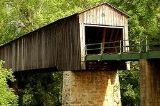
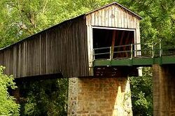
The name Euharlee is derived from a Native American word meaning "she laughs as she runs." Euharlee is home to Georgia's oldest covered bridge.
 2007 estimates show the population will rise to 4,121 residents. A large increase from the 1,600 residents at the 1995 census. The population has more than doubled in 10 years... in direct expansion of Cartersville.
of 2000, there were 3,208 people, 1,004 households, and 863 families residing in the city. The population density
was 694.6 people per square mile (268.1/km²). There were 1,057 housing units at an average density of 228.8 per square mile (88.3/km²). The racial makeup of the city was 89.31% White, 7.64% African American, 0.50% Native American, 0.62% Asian, 1.12% from other races
, and 0.81% from two or more races. Hispanic or Latino of any race were 2.71% of the population.
There were 1,003 households out of which 55.9% had children under the age of 18 living with them, 71.8% were married couples
living together, 8.6% had a female householder with no husband present, and 14.0% were non-families. 10.7% of all households were made up of individuals and 1.4% had someone living alone who was 65 years of age or older. The average household size was 3.20 and the average family size was 3.43.
In the city the population was spread out with 36.4% under the age of 18, 7.9% from 18 to 24, 38.3% from 25 to 44, 14.1% from 45 to 64, and 3.2% who were 65 years of age or older. The median age was 28 years. For every 100 females there were 95.3 males. For every 100 females age 18 and over, there were 94.2 males.
The median income for a household in the city was $53,714, and the median income for a family was $55,912. Males had a median income of $38,382 versus $24,631 for females. The per capita income
for the city was $17,483. About 1.7% of families and 3.0% of the population were below the poverty line, including 3.3% of those under age 18 and none of those age 65 or over.
Euharlee Elementary's current Principal is Sharon Collum
, and the Assistant Principal is Johnnie Coats. The office staff includesDonna Evans, Sarah Black, Beth Gudger, and Wendy Allen. The nurse is Darlene Brown. The Media Specialist is Linda McCoy, and the Media Clerk is Paula Hendricks. The full list of staff and faculty can be found on the school's website.
The school's Mission Statement is "The faculty and staff at Euharlee Elementary School are committed to educating children to become lifelong learners in a global society. We hope to instill academic values in students that they may successfully transition through life while crossing the bridge to the future." There is an annual Character Day Parade held, and pictures can be found on the school's website.
Woodland Middle School at Euharlee's current Principal is Lamar Barnes, and the Assistant Principals are Hope McCauley and Wes Dickey. Lamar Barnes is the only Principal WMSE has had since its opening in 2000.
The school's Mission Statement is "Our mission is to provide the transition from the nurturing environment of elementary school to the independent environment of high school while offering our students quality standards-based instruction and the opportunity to develop emerging skills needed to become life long learners."
The Festival was increased and relocated from Osborne Park with the completion of a Pavilion located behind the Covered Bridge Library and Covered Bridge Museum in 2005.
Bartow County, Georgia
Bartow County is a county located in the U.S. state of Georgia. As of the 2010 census, the population was 100,157. According to the U.S. Census Bureau's July 1, 2009 estimate, the county's explosive growth resulted in a population of 96,217, a 26.5% increase in less than ten years...
, Georgia
Georgia (U.S. state)
Georgia is a state located in the southeastern United States. It was established in 1732, the last of the original Thirteen Colonies. The state is named after King George II of Great Britain. Georgia was the fourth state to ratify the United States Constitution, on January 2, 1788...
, United States
United States
The United States of America is a federal constitutional republic comprising fifty states and a federal district...
. The population was 3,208 at the 2000 census. The city's explosive growth is evident as of the 2005 census the city's population rose to 3,859, and for 2006 estimates, Euharlee showed a population of 4,059. http://www.city-data.com/city/Euharlee-Georgia.html
Euharlee, Georgia is a bedroom community of Cartersville which is located 9 miles to the east, but they are connected through Euharlee Road, and by a chain of subdivisions and homes. It is next to Plant Bowen, which has the second largest generating capacity of any coal-fired power plant in the United States.
Geography
Euharlee is located at 34°8′50"N 84°56′11"W (34.147174, -84.936445).According to the United States Census Bureau
United States Census Bureau
The United States Census Bureau is the government agency that is responsible for the United States Census. It also gathers other national demographic and economic data...
, the city has a total area of 4.7 square miles (12.2 km²), of which, 4.6 square miles (11.9 km²) of it is land and 0.1 square mile (0.258998811 km²) of it (2.33%) is water.
The name Euharlee is derived from a Native American word meaning "she laughs as she runs." Euharlee is home to Georgia's oldest covered bridge.
Demographics
As of the censusCensus
A census is the procedure of systematically acquiring and recording information about the members of a given population. It is a regularly occurring and official count of a particular population. The term is used mostly in connection with national population and housing censuses; other common...
of 2000, there were 3,208 people, 1,004 households, and 863 families residing in the city. The population density
Population density
Population density is a measurement of population per unit area or unit volume. It is frequently applied to living organisms, and particularly to humans...
was 694.6 people per square mile (268.1/km²). There were 1,057 housing units at an average density of 228.8 per square mile (88.3/km²). The racial makeup of the city was 89.31% White, 7.64% African American, 0.50% Native American, 0.62% Asian, 1.12% from other races
Race (United States Census)
Race and ethnicity in the United States Census, as defined by the Federal Office of Management and Budget and the United States Census Bureau, are self-identification data items in which residents choose the race or races with which they most closely identify, and indicate whether or not they are...
, and 0.81% from two or more races. Hispanic or Latino of any race were 2.71% of the population.
There were 1,003 households out of which 55.9% had children under the age of 18 living with them, 71.8% were married couples
Marriage
Marriage is a social union or legal contract between people that creates kinship. It is an institution in which interpersonal relationships, usually intimate and sexual, are acknowledged in a variety of ways, depending on the culture or subculture in which it is found...
living together, 8.6% had a female householder with no husband present, and 14.0% were non-families. 10.7% of all households were made up of individuals and 1.4% had someone living alone who was 65 years of age or older. The average household size was 3.20 and the average family size was 3.43.
In the city the population was spread out with 36.4% under the age of 18, 7.9% from 18 to 24, 38.3% from 25 to 44, 14.1% from 45 to 64, and 3.2% who were 65 years of age or older. The median age was 28 years. For every 100 females there were 95.3 males. For every 100 females age 18 and over, there were 94.2 males.
The median income for a household in the city was $53,714, and the median income for a family was $55,912. Males had a median income of $38,382 versus $24,631 for females. The per capita income
Per capita income
Per capita income or income per person is a measure of mean income within an economic aggregate, such as a country or city. It is calculated by taking a measure of all sources of income in the aggregate and dividing it by the total population...
for the city was $17,483. About 1.7% of families and 3.0% of the population were below the poverty line, including 3.3% of those under age 18 and none of those age 65 or over.
Places of Interest
- Black Pioneer's Cemetery is an area of downtown Euharlee dedicated to preserving the gravesites of several early African-American settlers of the region.
- Euharlee Covered BridgeEuharlee Covered BridgeThe Euharlee Covered Bridge, also known as the Euharlee Creek Covered Bridge or rarely the Lowry Bridge, is a wooden covered bridge crossing Euharlee Creek in Euharlee, Georgia, a small town west of Cartersville. The bridge was built after the raging creek swept away an old bridge on the property...
goes over the Euharlee CreekEuharlee CreekEuharlee Creek is a 21-mile-long waterway which traverses across two counties in Georgia, Bartow County and Polk County. It begins in Polk County, GA near the city of Rockmart, GA and joins the Etowah River in Euharlee, GA. The historic Euharlee Covered Bridge spans across Euharlee Creek....
. It is the oldest covered bridge in the state of Georgia. It was built in 1889 by Washington W. King, son of Horace KingHorace KingHorace Maybray King, Baron Maybray-King, PC , was a British politician who served as a Labour Member of Parliament from 1950 until 1970 before becoming a life peer. Following the death of Harry Hylton-Foster in September 1965, King, who had served as deputy speaker for ten months, became the...
, and was formerly known as Lowry Bridge. - Covered Bridge Museum is a small museum located a stone's throw from the Euharlee Covered Bridge. The museum features an assortment of local artifacts from the early American Indian habitation to an exhibit featuring "Gone with the Wind" memorabilia.
- Kingston Saltpeter CaveKingston Saltpeter CaveKingston Saltpeter Cave is the largest cave in Bartow County, Georgia, United States of America, and was formerly used as a source of saltpeter, the critical oxidizing component of gunpowder, by the Confederate States of America during the American Civil War...
is the largest cave in Bartow County and was used to help produce gunpowder for the Confederate States of AmericaConfederate States of AmericaThe Confederate States of America was a government set up from 1861 to 1865 by 11 Southern slave states of the United States of America that had declared their secession from the U.S...
during the American Civil WarAmerican Civil WarThe American Civil War was a civil war fought in the United States of America. In response to the election of Abraham Lincoln as President of the United States, 11 southern slave states declared their secession from the United States and formed the Confederate States of America ; the other 25...
. - Johnny Mitchells Smokehouse: Award winning BBQ with many vegetarian options. Unique and cozy atmosphere with the friendliest owners. http://www.johnnymitchellssmokehouse.com/
Schools
Euharlee is home to two schools within the Bartow County School system. Woodland Middle School at Euharlee and Euharlee Elementary School are located on Euharlee Road, and are directly across the street from each other.Euharlee Elementary's current Principal is Sharon Collum
, and the Assistant Principal is Johnnie Coats. The office staff includesDonna Evans, Sarah Black, Beth Gudger, and Wendy Allen. The nurse is Darlene Brown. The Media Specialist is Linda McCoy, and the Media Clerk is Paula Hendricks. The full list of staff and faculty can be found on the school's website.
The school's Mission Statement is "The faculty and staff at Euharlee Elementary School are committed to educating children to become lifelong learners in a global society. We hope to instill academic values in students that they may successfully transition through life while crossing the bridge to the future." There is an annual Character Day Parade held, and pictures can be found on the school's website.
Woodland Middle School at Euharlee's current Principal is Lamar Barnes, and the Assistant Principals are Hope McCauley and Wes Dickey. Lamar Barnes is the only Principal WMSE has had since its opening in 2000.
The school's Mission Statement is "Our mission is to provide the transition from the nurturing environment of elementary school to the independent environment of high school while offering our students quality standards-based instruction and the opportunity to develop emerging skills needed to become life long learners."
Fall Festival
There is an annual Fall Festival held with the Covered Bridge as the focal point. It is held Labor Day weekend, running from Friday until Sunday. Local schools are invited to showcase choral and band ensembles throughout the weekend. Crafts and foods are sold by local vendors. There are rides for the children as well.The Festival was increased and relocated from Osborne Park with the completion of a Pavilion located behind the Covered Bridge Library and Covered Bridge Museum in 2005.
Restaurants
The restaurants located in Euharlee are Domino's Pizza and Johnny Mitchell's Smokehouse.External links
- http://www.euharlee.com
- http://www.n-georgia.com/euharlee-creek-bridge.htm
- http://www.bartow.k12.ga.us/education/school/school.php?sectiondetailid=293
- http://www.bartow.k12.ga.us/education/school/school.php?sectionid=13
- http://www.superpages.com/yellowpages/C-Restaurants/S-GA/T-Euharlee/