
Poquessing Creek
Encyclopedia
Poquessing Creek is a 10.3 miles (16.6 km) creek, a right tributary
of the Delaware River
, that forms part of the boundary between Bucks County
and the northeast
section of Philadelphia, Pennsylvania
. It has been part of the boundary between Bucks and Philadelphia counties since 1682.
The creek arises in Trevose
and meanders to the southeast before emptying into the Delaware River. The name Poquessing comes from the Lenape
"Poetquessnink," meaning "place of the mice." The mouth of the Poquessing on the Delaware was first proposed as the site for William Penn
's Philadelphia, and for many years the surrounding area was known as "Old Philadelphia."
The Poquessing watershed encompasses an area of approximately 21.5 square miles (55.7 km²), consisting of portions of Philadelphia, Montgomery
, and Bucks counties, including the municipalities of Philadelphia, Upper Southampton, Lower Southampton, Lower Moreland, and Bensalem.
Poquessing Creek and its tributary streams have largely escaped the "channelization" process that has transformed other watersheds
in the city. Other streams have had at least some significant portion of a tributary transformed into a storm sewer
, as the map at this site discloses. This sewerization process had been used in the past to allow land to be leveled and filled in order to preserve the traditional, regular rectangular grid of streets and property lines so common to the city. By the 1930s this process was seen as creating many problems.
During the late 1950s, housing in new developments was built with curving through-streets that conformed to the natural topography, avoiding the need to fill or level the terrain. The Morrell Park
neighborhood was the first in Philadelphia to follow this new pattern, avoiding for years any development near the stream valley of Byberry Creek
, which flows through and about the neighborhood before its confluence with the Poquessing (though later years saw development much closer to the stream than originally envisioned). Channelization of the Poquessing affected only a tiny unnamed creek below Grant Avenue near Fluehr Park.
Though Byberry Creek
and its two branches, Wilsons Run and Waltons Run, remain free-flowing, their entire courses are owned and operated by the city as an integral part of the city's storm sewer system, and are so marked on city departmental maps. Despite this circumstance, they have lovely courses during low water flows.
Tributary
A tributary or affluent is a stream or river that flows into a main stem river or a lake. A tributary does not flow directly into a sea or ocean...
of the Delaware River
Delaware River
The Delaware River is a major river on the Atlantic coast of the United States.A Dutch expedition led by Henry Hudson in 1609 first mapped the river. The river was christened the South River in the New Netherland colony that followed, in contrast to the North River, as the Hudson River was then...
, that forms part of the boundary between Bucks County
Bucks County, Pennsylvania
- Industry and commerce :The boroughs of Bristol and Morrisville were prominent industrial centers along the Northeast Corridor during World War II. Suburban development accelerated in Lower Bucks in the 1950s with the opening of Levittown, Pennsylvania, the second such "Levittown" designed by...
and the northeast
Northeast Philadelphia
Northeast Philadelphia, nicknamed Northeast Philly, the Northeast and the Great Northeast, is a section of the city of Philadelphia, Pennsylvania. According to the 2000 Census, the Northeast has a sizable percentage of the city's 1.547 million people — a population of between 300,000 and 450,000,...
section of Philadelphia, Pennsylvania
Pennsylvania
The Commonwealth of Pennsylvania is a U.S. state that is located in the Northeastern and Mid-Atlantic regions of the United States. The state borders Delaware and Maryland to the south, West Virginia to the southwest, Ohio to the west, New York and Ontario, Canada, to the north, and New Jersey to...
. It has been part of the boundary between Bucks and Philadelphia counties since 1682.
The creek arises in Trevose
Trevose, Pennsylvania
Trevose is a neighborhood of Bensalem and Lower Southampton in Pennsylvania, which is north of and borders northeastern Philadelphia. It shares a zip code with Feasterville-Trevose. It is not a municipality. U.S. 1 runs through the town as well as the Pennsylvania Turnpike, but Trevose's main road...
and meanders to the southeast before emptying into the Delaware River. The name Poquessing comes from the Lenape
Lenape language
The Delaware languages, also known as the Lenape languages, are Munsee and Unami, two closely related languages of the Eastern Algonquian subgroup of the Algonquian language family...
"Poetquessnink," meaning "place of the mice." The mouth of the Poquessing on the Delaware was first proposed as the site for William Penn
William Penn
William Penn was an English real estate entrepreneur, philosopher, and founder of the Province of Pennsylvania, the English North American colony and the future Commonwealth of Pennsylvania. He was an early champion of democracy and religious freedom, notable for his good relations and successful...
's Philadelphia, and for many years the surrounding area was known as "Old Philadelphia."
The Poquessing watershed encompasses an area of approximately 21.5 square miles (55.7 km²), consisting of portions of Philadelphia, Montgomery
Montgomery County, Pennsylvania
Montgomery County is a county located in the U.S. state of Pennsylvania, in the United States. As of 2010, the population was 799,874, making it the third most populous county in Pennsylvania . The county seat is Norristown.The county was created on September 10, 1784, out of land originally part...
, and Bucks counties, including the municipalities of Philadelphia, Upper Southampton, Lower Southampton, Lower Moreland, and Bensalem.
Poquessing Creek and its tributary streams have largely escaped the "channelization" process that has transformed other watersheds
Drainage basin
A drainage basin is an extent or an area of land where surface water from rain and melting snow or ice converges to a single point, usually the exit of the basin, where the waters join another waterbody, such as a river, lake, reservoir, estuary, wetland, sea, or ocean...
in the city. Other streams have had at least some significant portion of a tributary transformed into a storm sewer
Storm drain
A storm drain, storm sewer , stormwater drain or drainage well system or simply a drain or drain system is designed to drain excess rain and ground water from paved streets, parking lots, sidewalks, and roofs. Storm drains vary in design from small residential dry wells to large municipal systems...
, as the map at this site discloses. This sewerization process had been used in the past to allow land to be leveled and filled in order to preserve the traditional, regular rectangular grid of streets and property lines so common to the city. By the 1930s this process was seen as creating many problems.
During the late 1950s, housing in new developments was built with curving through-streets that conformed to the natural topography, avoiding the need to fill or level the terrain. The Morrell Park
Morrell Park, Philadelphia, Pennsylvania
Morrell Park is a neighborhood located in the Northeast section of Philadelphia, Pennsylvania, United States. It is located on the eastern side of the Far Northeast, north of Grant Avenue and east of Northeast Philadelphia Airport.-Characteristics:...
neighborhood was the first in Philadelphia to follow this new pattern, avoiding for years any development near the stream valley of Byberry Creek
Byberry Creek
Byberry Creek is a tributary of Poquessing Creek in northeastern Philadelphia, Pennsylvania in the United States.Byberry Creek is formed from two branches that flow through Northeast Philadelphia, Wilsons Run and Waltons Run....
, which flows through and about the neighborhood before its confluence with the Poquessing (though later years saw development much closer to the stream than originally envisioned). Channelization of the Poquessing affected only a tiny unnamed creek below Grant Avenue near Fluehr Park.
Though Byberry Creek
Byberry Creek
Byberry Creek is a tributary of Poquessing Creek in northeastern Philadelphia, Pennsylvania in the United States.Byberry Creek is formed from two branches that flow through Northeast Philadelphia, Wilsons Run and Waltons Run....
and its two branches, Wilsons Run and Waltons Run, remain free-flowing, their entire courses are owned and operated by the city as an integral part of the city's storm sewer system, and are so marked on city departmental maps. Despite this circumstance, they have lovely courses during low water flows.
Tributaries
- Black Lake Run
- Bloody Run
- Byberry CreekByberry CreekByberry Creek is a tributary of Poquessing Creek in northeastern Philadelphia, Pennsylvania in the United States.Byberry Creek is formed from two branches that flow through Northeast Philadelphia, Wilsons Run and Waltons Run....
- Colberts Run
- Elwoods Run
- Waltons Run
- Wilsons Run
Historic bridges
Several historic bridges cross the Poquessing.- A two-span, closed-spandrel, stone arch bridge, built in 1805, originally carried the King's Highway, later the Byberry and Bensalem Turnpike. It was improved in 1917 to carry the new Lincoln HighwayLincoln HighwayThe Lincoln Highway was the first road across the United States of America.Conceived and promoted by entrepreneur Carl G. Fisher, the Lincoln Highway spanned coast-to-coast from Times Square in New York City to Lincoln Park in San Francisco, originally through 13 states: New York, New Jersey,...
but was bypassed by the Roosevelt BoulevardRoosevelt BoulevardThe following roads are called Roosevelt Boulevard:*Roosevelt Boulevard in Jacksonville, Florida*Roosevelt Boulevard between Marmora and Ocean City, New Jersey*Roosevelt Boulevard in Philadelphia, Pennsylvania...
in 1921. It is no longer in use. - A three-span stone arch bridge, built in 1845, carrying Red Lion Road near the site of the old Red Lion InnThe Red Lion Inn - Bensalem, PAThe Red Lion Inn was a historic inn located near the Red Lion Bridge just outside Philadelphia, Pennsylvania, in the United States. The Inn was located on the Kings Highway at the bridge across Poquessing Creek...
is still in use. - A two-span, closed-spandrel, stone arch bridge at Richlieu Road, built in 1840, is no longer in use.
- A two-span, 42-ft-long, closed-spandrel, stone arch bridge at Century Lane, built in 1853 to connect the villages of Mechanicsville (now part of Philadelphia) and Elizabethtown, remains in use.
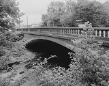
- A single-span concrete arch bridge where Frankford Avenue meets Bristol Pike (both U.S. Route 13U.S. Route 13U.S. Route 13 is a north–south U.S. highway established in 1926 that runs for from Interstate 95 just north of Fayetteville, North Carolina to the northeastern suburbs of Philadelphia, Pennsylvania, in Morrisville. In all, it traverses five states in the Atlantic coastal plain region,...
), built in 1904, is notable for its early modern use of concreteConcreteConcrete is a composite construction material, composed of cement and other cementitious materials such as fly ash and slag cement, aggregate , water and chemical admixtures.The word concrete comes from the Latin word...
. It was listed on the National Register of Historic PlacesNational Register of Historic PlacesThe National Register of Historic Places is the United States government's official list of districts, sites, buildings, structures, and objects deemed worthy of preservation...
in 1988 and remains in use today.
Quotation
From The History of Philadelphia's Watersheds and Sewers compiled by Adam Levine, Historical Consultant. Philadelphia Water Department:- Poquessing Creek rises in Montgomery County, crosses the north-west line of the late township of Byberry, where it receives a branch which flowed mainly through Moreland. It there bends northward into the county of Bucks, again southward, when it touches the township line, and flows south-east and south-west, forming the boundary line of Byberry, and turning to the south-east enters the Delaware.—Bloody run empties into it at Carter's mill, Black Lake creek at Mechanicsville, and Gilbert's run about a mile below.—Elwood's run and Wilson's run, which rise in Byberry township, unite to form Byberry creek, which enters the Poquessing near the Red Lion tavern.—Colbert's run and Walton's run unite and form Walton's creek, which flows into the Byberry. The latter meets the Poquessing within a mile of where it enters the Delaware River. On Lindstrom's map this stream is called Pouquessinge, La Riviere de Kakimon's. Mr. Henry defines Kakamon's to be a name for the pike, so that this was Pike creek; but Peder Lindstrom also has upon his map Drake Kylen, La Riviere des Dragons, or Dragon River. Johan Campanius calls it Drake Kylen. In a patent to Nicholas Moore it is called Poetquessingh, and on Holmes' map, Potquessin.
External links
- U.S. Geological Survey: PA stream gauging stations
- A photograph of Poquessing Creek from Windows Live LocalWindows Live LocalBing Maps is a web mapping service provided as a part of Microsoft's Bing suite of search engines and powered by the Bing Maps for Enterprise framework....
, after flowing under I-95Interstate 95 in PennsylvaniaInterstate 95 is an Interstate highway running from Miami, Florida north to Houlton, Maine. In the U.S. state of Pennsylvania, the route is known by many as the Delaware Expressway, but is officially named The Vietnam Veterans Memorial Highway. and locally known as "95"...
and just before emptying into the Delaware River. - Listing of the Frankford Avenue Bridge at Philadelphia Architects and Buildings
- Listing and photographs of the Frankford Avenue Bridge at the Historic American Engineering Record