

U.S. Route 301 in Virginia
Encyclopedia
U.S. Route 301 is a part of the U.S. Highway System that runs from Sarasota, Florida
to Glasgow, Delaware
. In Virginia
, the U.S. Highway runs 142.7 miles (229.7 km) from the North Carolina
state line near Skippers
north to the Maryland
state line at the Potomac River
near Dahlgren
. US 301 forms the local complement to Interstate 95
(I-95) from Emporia
to Petersburg
. The U.S. Highway runs concurrently
with US 1
between Petersburg and the state capital of Richmond
, where the highways form one of the main north–south avenues. US 301 continues north concurrent with Virginia State Route 2
(SR 2) to Bowling Green
, forming an eastern alternative to I-95 and US 1 north of Richmond. At Bowling Green, which is connected to I-95 by SR 207
, US 301 becomes the primary highway connecting Richmond and the Northern Neck
with Southern Maryland
. US 301 was constructed in four main segments: as the original SR 24 and then US 17-1 south of Petersburg, as US 1 from Petersburg to Richmond, as SR 2 from Richmond to Bowling Green, and as part of SR 207 toward Dahlgren. US 301 replaced US 17-1 in the early 1930s and was extended from Petersburg north along its current course into Maryland when the Potomac River Bridge was completed in 1940.
from North Carolina as two-lane Skippers Road, which closely parallels CSX
's North End Subdivision rail line, crosses Fontaine Creek, and passes through the hamlet of Skippers. The U.S. Highway temporarily expands to a four-lane divided highway through its trumpet interchange with I-95 before becoming two lanes again as it enters the independent city
of Emporia as Main Street. US 301 passes through downtown Emporia, crosses the Meherrin River
, and has a grade crossing of Norfolk Southern Railway
's Franklin District
immediately to the south of its intersection with US 58 Business (Atlantic Street). The U.S. Highway expands to a four-lane undivided highway and has a partial cloverleaf interchange with US 58
before re-entering Greensville County as four-lane divided Sussex Drive. Northbound US 301 receives a ramp from northbound I-95 a short distance south of I-95's diamond interchange
with SR 614 (Otterdam Road) just west of the US 301–SR 614 intersection.
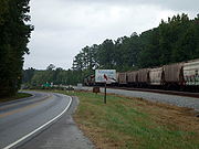 US 301 crosses over to the east side of the CSX rail line and enters Sussex County
, where the highway's name changes to Blue Star Highway. The U.S. Highway has a diamond interchange with I-95 where the Interstate crosses to the east side of the highway. US 301 meets the eastern end of SR 139
(Jarratt Avenue) while passing through the town of Jarratt
. North of Jarratt, the U.S. Highway reduces to two lanes and begins to closely parallel the southbound lanes of I-95, with temporary diversions from the Interstate where secondary highways cross or have interchanges with the Interstate. US 301 crosses the Nottoway River
before reaching Stony Creek
, where the namesake creek enters the Nottoway River. At Stony Creek, the U.S. Highway has a junction with SR 40
(Sussex Drive) and a short concurrency with SR 40 Business, which turns west to pass through the town as Lee Avenue.
South of Carson
, US 301 enters Prince George County
and its name changes to Crater Road. The U.S. Highway continues to closely parallel I-95 to Templeton
, where the highway has a short concurrency with SR 35
(Courtland Road), during which the highways cross to the east side of I-95 and have an interchange with the Interstate. US 301 turns north from SR 35 at the same intersection that receives a ramp from northbound I-95 and serves as the southern terminus of SR 156
. US 301 and SR 156 have a short concurrency before SR 156 leaves as Prince George Drive toward Hopewell
. The U.S. Highway crosses Warwick Swamp and has another interchange with I-95, swapping to the west side of the Interstate. US 301 enters the city of Petersburg and expands to a four-lane divided highway just south of Wagner Road. The U.S. Highway crosses over Norfolk Southern's Norfolk District rail line in the Walnut Hill neighborhood of Petersburg, where the highway meets the southern end of US 301 Alternate (Sycamore Street).
US 301 has another interchange with I-95 between I-95's junctions with I-85
and US 460
, which runs concurrently with I-85 and I-95 through Petersburg. US 301 becomes concurrent with US 460 Business at the interchange that is next to the site of the Battle of the Crater
. East of Old Towne Petersburg, US 301 has intersections with Wythe Street and Washington Street, which form an east–west one-way pair
that US 460 Business follows through the downtown area. Wythe Street also carries eastbound SR 36
; westbound SR 36 follows Washington Street to Crater Road, where US 301 and westbound SR 36 begin to run concurrently. US 301 has its own east–west one-way pair through Old Towne Petersburg: southbound US 301 follows Bank Street and northbound US 301 follows Bollingbrook Street with westbound SR 36. The one-way pair continues west to 2nd Street, where US 301 receives the northern end of its alternate route, SR 36 continues west along Bollingbrook Street, and US 301 joins US 1 on 2nd Street to leave Petersburg by crossing the Martin Luther King Jr. Memorial Bridge
over the Appomattox River
.
as Boulevard, a five-lane road with center turn lane. The U.S. Highways are joined by SR 144
(Temple Avenue) south of the highways' crossing of CSX's North End Subdivision. The three highways cross Swift Creek
into Chesterfield County
, where SR 144 splits northwest as Harrowgate Road and the U.S. Highways continue along four-lane undivided Jefferson Davis Highway. US 301 and US 1 pass under the railroad again south of Chester
, where the highway passes the main campus of John Tyler Community College
and intersects SR 10
(West Hundred Road). North of Chester, the U.S. Highways have a cloverleaf interchange
with SR 288
. US 301 and US 1 continue as a divided highway through the industrial community of Bellwood
, where the highways cross over CSX's Bellwood Subdivision and pass to the east of Defense Supply Center, Richmond
. The highway expands to six lanes just north of its crossing of Falling Creek
near the site of the Falling Creek Ironworks
and Ampthill plantation and just south of its cloverleaf interchange with SR 150
(Chippenham Parkway).
US 301 and US 1 pass through the community of Bensley
before entering the city of Richmond near Walmsley Boulevard. The U.S. Highways intersect SR 161
(Bells Road), which leads to the Port of Richmond on the James River
. North of the Model Tobacco Building
complex, US 301 and US 1 enter the Manchester
section of Richmond. The highway's name changes to Cowardin Avenue at its intersection with US 360
(Hull Street). North of US 60
(Semmes Avenue), US 301 and US 1 have a partial interchange with Riverside Drive, allowing access to and from the north, and cross the James River and Belle Isle
on the Robert E. Lee Memorial Bridge
. The bridge crosses over CSX's Rivanna Subdivision before reaching a partial interchange with 2nd Street, allowing access to and from the south, at its northern end, west of the Tredegar Iron Works
. US 301 and US 1 follow Belvidere Street through the Oregon Hill
neighborhood of Richmond, which lies to the east of Hollywood Cemetery
, site of the James Monroe Tomb
.
 After crossing SR 195
(Downtown Expressway), which is indirectly accessed via Byrd Street and Cumberland Street, US 301 and US 1 pass between the eastern edge of the Virginia Commonwealth University
campus and the western edge of Downtown Richmond
. There, the U.S. Highways intersect SR 147
, which follows Cary Street eastbound and Main Street westbound. US 301 and US 1 curve northeast between Monroe Park
and The Commonwealth Club
and intersect US 250
(Broad Street). North of its interchange with I-64
and I-95, the U.S. Highways curve north, cross CSX's Richmond Terminal Subdivision. and continue along four-lane Chamberlayne Avenue. US 301 and US 1 meet the northern end of SR 197
at Laburnum Avenue on their way to the northern edge of Richmond. At Azalea Avenue, US 1 and US 301 diverge; US 1 turns west onto Azalea Avenue and then north onto Brook Road while US 301 continues north on Chamberlayne Avenue concurrent with SR 2, which has its southern terminus at the intersection.
. A short distance north of the city limits, the carriageways split, with the southbound lanes crossing to the west of I-95. Several ramps connect the two highways with I-95 in the forested area around Upham Brook. After I-95 veers northwest and the carriageways rejoin, US 301 and SR 2 pass through the suburb of Chamberlayne
. The highways meet the eastern end of Parham Road, the main east–west boulevard of Henrico County, just before crossing the Chickahominy River
into Hanover County
. US 301 and SR 2 meet I-295
at a cloverleaf interchange
just north of the county line. The two highways continue through a suburban area where they pass under CSX's Piedmont Subdivision. North of Hanover High School
, US 301 and SR 2 reduce to two lanes and the road's name changes to Hanover Courthouse Road. At Hanover Courthouse
, the highway meets the eastern end of SR 54
(Patrick Henry Road). US 301 and SR 2 also pass the 18th century Hanover County Courthouse
, where Patrick Henry
argued the case of the Parson's Cause
, and the Hanover Tavern
, where the Barksdale Theater opened the first dinner theater
in the United States in 1953.
 US 301 and SR 2 cross the Pamunkey River
into Caroline County
. The road, now named Richmond Turnpike, intersects SR 30
(Dawn Boulevard) in the hamlet of Bowersville
, also known as Dawn. The two highways run straight for 13 miles (20.9 km); near the north end of the straight, the highways cross the Mattaponi River
. At the north end of the straight, SR 2 and US 301 expand to a four-lane divided highway that lasts until the two highways pass under SR 207
(Bowling Green Bypass). US 301 leaves SR 2 on a two-way ramp to the bypass to head toward the Potomac River Bridge into Charles County, Maryland
. SR 2 and US 301 Business continue straight into the town of Bowling Green as Main Street while US 301 turns onto a two-lane ramp that leads to the Bowling Green Bypass. US 301 joins the four-lane divided bypass at SR 207's eastern terminus. After passing around the east side of the town of Bowling Green, the U.S. Highway receives the northern end of its business route, Broaddus Avenue.
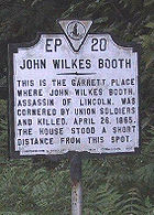
US 301 continues northeast as A.P. Hill Boulevard, which enters the eponymous military installation
. East of the U.S. Army base's main entrance, the U.S. Highway passes through the forested Army reservation for 9 miles (14.5 km) without an intersection. Near the eastern edge of Fort A.P. Hill, US 301 passes the site of the Garrett farmhouse and barn where John Wilkes Booth
was killed by federal troops 12 days after he had assassinated Abraham Lincoln. At the eastern edge of the military base, the highway intersects US 17
(Tidewater Trail). US 301 becomes an undivided highway as it passes through the town of Port Royal
as Main Street, then uses the James Madison Memorial Bridge to cross the Rappahannock River
into King George County
.
US 301 continues north as James Madison Parkway and passes Emmanuel Episcopal Church
and Belle Grove
, the birthplace of James Madison
, in the hamlet of Port Conway
on the north side of the river. The U.S. Highway intersects SR 3
(Kings Highway) at Office Hall
and SR 205
(Ridge Road) at Edgehill
. Both highways connect US 301 with King George
, the county seat
of King George County. US 301 continues northeast to Owens
, where the highway has intersections with SR 218
(Windsor Drive) and SR 206
(Dahlgren Road). SR 206 leads to the community of Dahlgren
, which is home to the Dahlgren Division
of the Naval Surface Warfare Center
. US 301 parallels the northern perimeter of the naval reservation on its way to the Potomac River. The U.S. Highway reduces to two lanes immediately before using the Harry W. Nice Memorial Bridge to cross the Potomac River into Maryland.
southwest to North Carolina along current State Route 627 (via Brink and Barley). It connected at the state line to North Carolina Highway 40.
The "Halifax Road" from North Carolina via Emporia to the junction with State Route 35 (then State Route 5) south of Petersburg was not assigned as part of the initial state highway system in 1918. In March 1923, a delegation from Petersburg appeared before the State Highway Commission, requesting that this be added to the system. They claimed that the road was to be included in the system, but it was left out through an error. SR 24 south of Emporia was realigned in April 1924 to the present US 301 alignment, and North Carolina Highway 40 was realigned at around the same time to match. Over the next several years, the Halifax Road from Emporia to SR 35 was added to the state highway system as SR 24. By 1927, Route 24 had replaced Route 35 north of their junction to Petersburg, and was completely concurrent with U.S. Route 17-1. The number was decommissioned in the 1933 renumbering, at which time the present State Route 24 was designated.
Sarasota, Florida
Sarasota is a city located in Sarasota County on the southwestern coast of the U.S. state of Florida. It is south of the Tampa Bay Area and north of Fort Myers...
to Glasgow, Delaware
Glasgow, Delaware
Glasgow is a census-designated place in New Castle County, Delaware, United States. The population was 12,840 at the 2000 census.-Geography:Glasgow is located at ....
. In Virginia
Virginia
The Commonwealth of Virginia , is a U.S. state on the Atlantic Coast of the Southern United States. Virginia is nicknamed the "Old Dominion" and sometimes the "Mother of Presidents" after the eight U.S. presidents born there...
, the U.S. Highway runs 142.7 miles (229.7 km) from the North Carolina
North Carolina
North Carolina is a state located in the southeastern United States. The state borders South Carolina and Georgia to the south, Tennessee to the west and Virginia to the north. North Carolina contains 100 counties. Its capital is Raleigh, and its largest city is Charlotte...
state line near Skippers
Skippers, Virginia
Skippers is an unincorporated community in Greensville County, Virginia, United States, only three miles north of the North Carolina border. It is on U.S. Route 301 and Interstate 95. It is also a famous truck stop consisting of a Love's gas station and a McDonalds....
north to the Maryland
Maryland
Maryland is a U.S. state located in the Mid Atlantic region of the United States, bordering Virginia, West Virginia, and the District of Columbia to its south and west; Pennsylvania to its north; and Delaware to its east...
state line at the Potomac River
Potomac River
The Potomac River flows into the Chesapeake Bay, located along the mid-Atlantic coast of the United States. The river is approximately long, with a drainage area of about 14,700 square miles...
near Dahlgren
Dahlgren, Virginia
Dahlgren is a census-designated place in King George County, Virginia, United States. The population was 997 at the 2000 census. The community is located within the Northern Neck George Washington Birthplace American Viticultural Area winemaking appellation established by the United States...
. US 301 forms the local complement to Interstate 95
Interstate 95 in Virginia
In the Commonwealth of Virginia, Interstate 95 runs through the state. It runs concurrently for with Interstate 64 in Richmond, and meets the northern terminus of Interstate 85 in Petersburg. Though Interstate 95 was originally planned to go straight through Washington, D.C., it was instead...
(I-95) from Emporia
Emporia, Virginia
Emporia is an independent city located within the confines of Greensville County, Virginia, United States. The population was estimated to be 5,927 in 2010. The Bureau of Economic Analysis combines the city of Emporia with surrounding Greensville county for statistical purposes...
to Petersburg
Petersburg, Virginia
Petersburg is an independent city in Virginia, United States located on the Appomattox River and south of the state capital city of Richmond. The city's population was 32,420 as of 2010, predominantly of African-American ethnicity...
. The U.S. Highway runs concurrently
Concurrency (road)
A concurrency, overlap, or coincidence in a road network is an instance of one physical road bearing two or more different highway, motorway, or other route numbers...
with US 1
U.S. Route 1 in Virginia
U.S. Route 1 in the U.S. state of Virginia runs north–south through South Hill, Petersburg, Richmond, Fredericksburg, and Alexandria on its way from North Carolina to the 14th Street Bridge into the District of Columbia...
between Petersburg and the state capital of Richmond
Richmond, Virginia
Richmond is the capital of the Commonwealth of Virginia, in the United States. It is an independent city and not part of any county. Richmond is the center of the Richmond Metropolitan Statistical Area and the Greater Richmond area...
, where the highways form one of the main north–south avenues. US 301 continues north concurrent with Virginia State Route 2
Virginia State Route 2
Virginia State Route 2 is a primary state highway in the U.S. state of Virginia. The state highway runs from U.S. Route 1 and US 301 in Richmond north to US 1 Business, US 17 Business, and SR 3 Business in Fredericksburg. SR 2 connects Richmond and Fredericksburg via Bowling Green...
(SR 2) to Bowling Green
Bowling Green, Virginia
Bowling Green is an incorporated town in Caroline County, Virginia, United States. The population was 936 at the 2000 census.The county seat of Caroline County since 1803, Bowling Green is best known as the "cradle of American horse racing", the home of the second oldest Masonic Lodge, and the...
, forming an eastern alternative to I-95 and US 1 north of Richmond. At Bowling Green, which is connected to I-95 by SR 207
Virginia State Route 207
Virginia State Route 207 is a primary state highway in the U.S. state of Virginia. Known for most of its length as Rogers Clark Boulevard, the state highway runs from U.S. Route 1 in Ruther Glen east to US 301 and SR 2 in Bowling Green. SR 207 is a divided highway connection between Interstate...
, US 301 becomes the primary highway connecting Richmond and the Northern Neck
Northern Neck
The Northern Neck is the northernmost of three peninsulas on the western shore of the Chesapeake Bay in the Commonwealth of Virginia. This peninsula is bounded by the Potomac River on the north and the Rappahannock River on the south. It encompasses the following Virginia counties: Lancaster,...
with Southern Maryland
Southern Maryland
Southern Maryland in popular usage is composed of the state's southernmost counties on the "Western Shore" of the Chesapeake Bay. This region includes all of Calvert, Charles and St. Mary's counties and sometimes the southern portions of Anne Arundel and Prince George's counties.- History...
. US 301 was constructed in four main segments: as the original SR 24 and then US 17-1 south of Petersburg, as US 1 from Petersburg to Richmond, as SR 2 from Richmond to Bowling Green, and as part of SR 207 toward Dahlgren. US 301 replaced US 17-1 in the early 1930s and was extended from Petersburg north along its current course into Maryland when the Potomac River Bridge was completed in 1940.
North Carolina to Petersburg
US 301 enters Greensville County, VirginiaGreensville County, Virginia
As of the census of 2000, there were 11,560 people, 3,375 households, and 2,396 families residing in the county. The population density was 39 people per square mile . There were 3,765 housing units at an average density of 13 per square mile...
from North Carolina as two-lane Skippers Road, which closely parallels CSX
CSX Transportation
CSX Transportation operates a Class I railroad in the United States known as the CSX Railroad. It is the main subsidiary of the CSX Corporation. The company is headquartered in Jacksonville, Florida, and owns approximately 21,000 route miles...
's North End Subdivision rail line, crosses Fontaine Creek, and passes through the hamlet of Skippers. The U.S. Highway temporarily expands to a four-lane divided highway through its trumpet interchange with I-95 before becoming two lanes again as it enters the independent city
Independent city
An independent city is a city that does not form part of another general-purpose local government entity. These type of cities should not be confused with city-states , which are fully sovereign cities that are not part of any other sovereign state.-Historical precursors:In the Holy Roman Empire,...
of Emporia as Main Street. US 301 passes through downtown Emporia, crosses the Meherrin River
Meherrin River
The Meherrin River is a long river in the U.S. states of Virginia and North Carolina. It begins in central Virginia, about northwest of Emporia, and flows roughly east-southeast into North Carolina, where it joins the larger Chowan River....
, and has a grade crossing of Norfolk Southern Railway
Norfolk Southern Railway
The Norfolk Southern Railway is a Class I railroad in the United States, owned by the Norfolk Southern Corporation. With headquarters in Norfolk, Virginia, the company operates 21,500 route miles in 22 eastern states, the District of Columbia and the province of Ontario, Canada...
's Franklin District
Franklin District
The territorial authority of Franklin District was abolished on 31 October 2010 and was divided between Auckland Council in the Auckland Region to the north and Waikato and Hauraki districts in the Waikato Region to the south and east. It was administered from the town of Pukekohe...
immediately to the south of its intersection with US 58 Business (Atlantic Street). The U.S. Highway expands to a four-lane undivided highway and has a partial cloverleaf interchange with US 58
U.S. Route 58
U.S. Route 58 is an east–west U.S. Highway that runs for from U.S. Route 25E just northwest of Harrogate, Tennessee to U.S. Route 60 in Virginia Beach, Virginia. Until 1996, when the Cumberland Gap Tunnel opened, US 58 ran only inside the commonwealth of Virginia...
before re-entering Greensville County as four-lane divided Sussex Drive. Northbound US 301 receives a ramp from northbound I-95 a short distance south of I-95's diamond interchange
Diamond interchange
A diamond interchange is a common type of road junction, used where a freeway crosses a minor road. The freeway itself is grade-separated from the minor road, one crossing the other over a bridge...
with SR 614 (Otterdam Road) just west of the US 301–SR 614 intersection.
Sussex County, Virginia
As of the census of 2000, there were 12,504 people, 4,126 households, and 2,809 families residing in the county. The population density was 26 people per square mile . There were 4,653 housing units at an average density of 10 per square mile...
, where the highway's name changes to Blue Star Highway. The U.S. Highway has a diamond interchange with I-95 where the Interstate crosses to the east side of the highway. US 301 meets the eastern end of SR 139
Virginia State Route 139
Virginia State Route 139 is a primary state highway in the U.S. state of Virginia. Known for most of its length as Jarratt Avenue, the state highway runs from SR 610 east to U.S. Route 301 and SR 631 within Jarratt...
(Jarratt Avenue) while passing through the town of Jarratt
Jarratt, Virginia
Jarratt is a town in Greensville and Sussex counties in the U.S. state of Virginia. The population was 589 at the 2000 census.-Geography:According to the United States Census Bureau, the town has a total area of 1.3 square miles , all land....
. North of Jarratt, the U.S. Highway reduces to two lanes and begins to closely parallel the southbound lanes of I-95, with temporary diversions from the Interstate where secondary highways cross or have interchanges with the Interstate. US 301 crosses the Nottoway River
Nottoway River
The Nottoway River is in southern Virginia and northeastern North Carolina. It is part of the Chowan River system, which flows into Albemarle Sound in North Carolina.-Cities and towns:Cities and towns along the river include:* Courtland, Virginia...
before reaching Stony Creek
Stony Creek, Virginia
Stony Creek is a town in Sussex County, Virginia, United States. The population was 202 at the 2000 census.-Geography:Stony Creek is located at ....
, where the namesake creek enters the Nottoway River. At Stony Creek, the U.S. Highway has a junction with SR 40
Virginia State Route 40
State Route 40 is a primary state highway in the southern part of the U.S. state of Virginia. It runs from State Route 8 at Woolwine east to State Route 10 at Spring Grove, about half the width of Virginia. It is the longest state-numbered route in Virginia.-Route description:SR 40 begins at SR 8...
(Sussex Drive) and a short concurrency with SR 40 Business, which turns west to pass through the town as Lee Avenue.
South of Carson
Carson, Virginia
Carson is an unincorporated community in Prince George County, Virginia, United States, located between Petersburg and Stony Creek, just west of Interstate 95.History...
, US 301 enters Prince George County
Prince George County, Virginia
As of the census of 2000, there were 33,047 people, 10,159 households, and 8,096 families residing in the county. The population density was 124 people per square mile . There were 10,726 housing units at an average density of 40 per square mile...
and its name changes to Crater Road. The U.S. Highway continues to closely parallel I-95 to Templeton
Templeton, Virginia
Templeton is a census-designated place in Prince George County, Virginia. The population as of the 2010 Census was 431....
, where the highway has a short concurrency with SR 35
Virginia State Route 35
Virginia State Route 35 is a primary state highway in the U.S. state of Virginia. The state highway runs from the North Carolina state line near Boykins, where the highway continues as North Carolina Highway 35 , north to SR 605 and SR 622 in Templeton. SR 35 is the main north–south...
(Courtland Road), during which the highways cross to the east side of I-95 and have an interchange with the Interstate. US 301 turns north from SR 35 at the same intersection that receives a ramp from northbound I-95 and serves as the southern terminus of SR 156
Virginia State Route 156
Virginia State Route 156 is a primary state highway in the U.S. state of Virginia. The state highway runs from U.S. Route 301 and SR 35 in Templeton north to US 360 Business in Mechanicsville. SR 156 follows a circuitous route through the eastern part of the Richmond–Petersburg...
. US 301 and SR 156 have a short concurrency before SR 156 leaves as Prince George Drive toward Hopewell
Hopewell, Virginia
Hopewell is an independent city in the Commonwealth of Virginia. The population was 22,591 at the 2010 Census . It is in Tri-Cities area of the Richmond-Petersburg region and is a portion of the Richmond Metropolitan Statistical Area...
. The U.S. Highway crosses Warwick Swamp and has another interchange with I-95, swapping to the west side of the Interstate. US 301 enters the city of Petersburg and expands to a four-lane divided highway just south of Wagner Road. The U.S. Highway crosses over Norfolk Southern's Norfolk District rail line in the Walnut Hill neighborhood of Petersburg, where the highway meets the southern end of US 301 Alternate (Sycamore Street).
US 301 has another interchange with I-95 between I-95's junctions with I-85
Interstate 85 in Virginia
Interstate 85 is a part of the Interstate Highway System that runs from Montgomery, Alabama to Petersburg, Virginia. In Virginia, the Interstate Highway runs from the North Carolina state line near Bracey north to I-95 in Petersburg. I-85 passes through the eastern part of Southside Virginia,...
and US 460
U.S. Route 460 in Virginia
U.S. Route 460 in Virginia runs east–west through the southern part of the state. It has two separate pieces in Virginia, joined by a relatively short section in West Virginia...
, which runs concurrently with I-85 and I-95 through Petersburg. US 301 becomes concurrent with US 460 Business at the interchange that is next to the site of the Battle of the Crater
Battle of the Crater
The Battle of the Crater was a battle of the American Civil War, part of the Siege of Petersburg. It took place on July 30, 1864, between the Confederate Army of Northern Virginia, commanded by General Robert E. Lee and the Union Army of the Potomac, commanded by Major General George G. Meade The...
. East of Old Towne Petersburg, US 301 has intersections with Wythe Street and Washington Street, which form an east–west one-way pair
One-way pair
A one-way pair, one-way couple, or just couplet is a pair of parallel, usually one-way streets that carry opposite directions of a signed route or major traffic flow, or sometimes opposite directions of a bus or streetcar route....
that US 460 Business follows through the downtown area. Wythe Street also carries eastbound SR 36
Virginia State Route 36
Virginia State Route 36 is a state highway in the U.S. state of Virginia. The state highway runs from SR 602 and SR 669 near Matoaca east to SR 10 in Hopewell. SR 36 is the main highway between Petersburg and Hopewell; within each independent city, the state highway follows a byzantine path...
; westbound SR 36 follows Washington Street to Crater Road, where US 301 and westbound SR 36 begin to run concurrently. US 301 has its own east–west one-way pair through Old Towne Petersburg: southbound US 301 follows Bank Street and northbound US 301 follows Bollingbrook Street with westbound SR 36. The one-way pair continues west to 2nd Street, where US 301 receives the northern end of its alternate route, SR 36 continues west along Bollingbrook Street, and US 301 joins US 1 on 2nd Street to leave Petersburg by crossing the Martin Luther King Jr. Memorial Bridge
Martin Luther King Jr. Memorial Bridge
The Martin Luther King Jr. Memorial Bridge carries Jefferson Davis Highway across the Appomattox River at the fall line. It joins Colonial Heights and Petersburg, Virginia....
over the Appomattox River
Appomattox River
The Appomattox River is a tributary of the James River, approximately long, in central and eastern Virginia in the United States, named for the Appomattocs Indian tribe who lived along its lower banks in the 17th century...
.
Petersburg to Richmond
US 301 and US 1 pass through the city of Colonial HeightsColonial Heights, Virginia
Colonial Heights is an independent city in Virginia, United States. The population was 17,411 as of 2010. The Bureau of Economic Analysis combines the City of Colonial Heights with Dinwiddie County for statistical purposes...
as Boulevard, a five-lane road with center turn lane. The U.S. Highways are joined by SR 144
Virginia State Route 144
Virginia State Route 144 is a primary state highway in the U.S. state of Virginia. The state highway runs from SR 36 at Fort Lee north to SR 145 at Centralia. SR 144's east–west segment is the main highway between Colonial Heights and both Fort Lee and Hopewell. The state highway's...
(Temple Avenue) south of the highways' crossing of CSX's North End Subdivision. The three highways cross Swift Creek
Swift Creek (Virginia)
Swift Creek is a river in the U.S. state of Virginia. It rises west of Richmond in Powhatan County and flows southeast, eventually forming the northern boundary of Colonial Heights, where it joins the Appomattox River.-References:...
into Chesterfield County
Chesterfield County, Virginia
Chesterfield County is a county located in the Commonwealth of Virginia, a state of the United States. In 2010, its population was estimated to be 316,236. Chesterfield County is now the fourth-largest municipality in Virginia . Its county seat is Chesterfield...
, where SR 144 splits northwest as Harrowgate Road and the U.S. Highways continue along four-lane undivided Jefferson Davis Highway. US 301 and US 1 pass under the railroad again south of Chester
Chester, Virginia
Chester is a census-designated place in Chesterfield County, Virginia, United States. The population was 20,987 at the 2010 census.-History:...
, where the highway passes the main campus of John Tyler Community College
John Tyler Community College
John Tyler Community College is a two-year, public institution of higher education and is the fifth largest of the 23 community colleges in Virginia. John Tyler is accredited by the Commission on Colleges of the Southern Association of Colleges and Schools, and offers 17 associate degree programs,...
and intersects SR 10
Virginia State Route 10
Virginia State Route 10 is a primary state highway in the U.S. state of Virginia. The state highway runs from U.S. Route 360 in Richmond east to SR 337 in Suffolk. SR 10 is a major suburban highway through Chesterfield County between the Southside of Richmond and Hopewell...
(West Hundred Road). North of Chester, the U.S. Highways have a cloverleaf interchange
Cloverleaf interchange
A cloverleaf interchange is a two-level interchange in which left turns, reverse direction in left-driving regions, are handled by ramp roads...
with SR 288
Virginia State Route 288
State Route 288 is a primary state highway in the U.S. state of Virginia. It is a freeway-standard partial beltway around the southwest side of Richmond...
. US 301 and US 1 continue as a divided highway through the industrial community of Bellwood
Bellwood, Virginia
Bellwood is a census-designated place in Chesterfield County, Virginia, United States. The population was 6,352 at the 2010 census.-Geography:Bellwood is located at ....
, where the highways cross over CSX's Bellwood Subdivision and pass to the east of Defense Supply Center, Richmond
Defense Supply Center, Richmond
Defense Supply Center, Richmond, or DSCR, serves as the Aviation Demand and Supply Chain manager for Defense Logistics Agency. It is located on the I-95 corridor in Chesterfield County, Virginia in the Southside area of the Greater Richmond Virginia. The installation comprises and was opened in...
. The highway expands to six lanes just north of its crossing of Falling Creek
Falling Creek
Falling Creek is a tributary of the James River located near Richmond, Virginia. Approximately in length, it varies in width between at its source to several hundred feet in the Falling Creek Reservoir. Falling Creek rises in the Salisbury section of northwestern Chesterfield County and empties...
near the site of the Falling Creek Ironworks
Falling Creek Ironworks
Falling Creek Ironworks was the first iron production facility in North America. It was established by the Virginia Company of London in Henrico Cittie on Falling Creek near its confluence with the James River. It was short-lived due to an attack by Native Americans in 1622.The long-lost site was...
and Ampthill plantation and just south of its cloverleaf interchange with SR 150
Virginia State Route 150
Virginia State Route 150 is a state highway in the U.S. state of Virginia. Known as Chippenham Parkway, the state highway runs from Interstate 95 and SR 895 in Bensley north to Parham Road and River Road near Tuckahoe in Henrico County...
(Chippenham Parkway).
US 301 and US 1 pass through the community of Bensley
Bensley, Virginia
Bensley is a census-designated place in Chesterfield County, Virginia, United States. The population was 5,819 at the 2010 census.-Geography:Bensley is located at ....
before entering the city of Richmond near Walmsley Boulevard. The U.S. Highways intersect SR 161
Virginia State Route 161
State Route 161 is a primary state highway in and near Richmond, Virginia, United States. It extends from an interchange with Interstate 95 in the independent city of Richmond north to an intersection with U.S...
(Bells Road), which leads to the Port of Richmond on the James River
James River
The James River may refer to:Rivers in the United States and their namesakes* James River * James River , North Dakota, South Dakota* James River * James River * James River...
. North of the Model Tobacco Building
Model Tobacco Building
Built from 1938-40, the Art Deco style Model Tobacco Building is the primary six-story building of a six building collection of buildings comprising a former tobacco factory. Located at 1100 Jefferson Davis Highway Built from 1938-40, the Art Deco style Model Tobacco Building is the primary...
complex, US 301 and US 1 enter the Manchester
Manchester, Virginia
Manchester, Virginia is a former independent city in Virginia in the United States. Prior to receiving independent status, it served as the county seat of Chesterfield County, between 1870 and 1876...
section of Richmond. The highway's name changes to Cowardin Avenue at its intersection with US 360
U.S. Route 360
U.S. Route 360 is a spur of US 60 in the U.S. state of Virginia. The U.S. Highway runs from US 58 Business, Virginia State Route 293, and SR 360 in Danville east to SR 644 in Reedville. US 360 connects Danville, South Boston, and Keysville in Southside Virginia with the state capital of...
(Hull Street). North of US 60
U.S. Route 60 in Virginia
U.S. Route 60 in Virginia runs west to east through the central part of the state, generally close to and paralleling the Interstate 64 corridor, except for the crossing of the Blue Ridge Mountains, and in the South Hampton Roads area....
(Semmes Avenue), US 301 and US 1 have a partial interchange with Riverside Drive, allowing access to and from the north, and cross the James River and Belle Isle
Belle Isle (Virginia)
Belle Isle is a small island in the James River in Richmond, Virginia in the United States. Belle Isle is owned by the city of Richmond, and has been designated a city park. It is accessible to pedestrian and bicycle traffic via a suspension footbridge that runs under the Robert E. Lee Bridge from...
on the Robert E. Lee Memorial Bridge
Robert E. Lee Memorial Bridge
The Robert E. Lee Memorial Bridge in Richmond, Virginia carries U.S. Route 1 and U.S. Route 301 across the James River at the fall line.The city acquired the original bridge from Richmond Bridge Corp in 1933, and it was named the James River Bridge but was later renamed for the Confederate general....
. The bridge crosses over CSX's Rivanna Subdivision before reaching a partial interchange with 2nd Street, allowing access to and from the south, at its northern end, west of the Tredegar Iron Works
Tredegar Iron Works
The Tredegar Iron Works was a historic iron foundry in Richmond, Virginia, United States of America, opened in 1837. During the American Civil War, the works served as the primary iron and artillery production facility of the Confederate States of America...
. US 301 and US 1 follow Belvidere Street through the Oregon Hill
Oregon Hill
Oregon Hill is a historically white working class neighborhood in Richmond, Virginia. Oregon Hill overlooks the James River and Belle Isle, and provides access to Hollywood Cemetery.-History:...
neighborhood of Richmond, which lies to the east of Hollywood Cemetery
Hollywood Cemetery
Hollywood Cemetery is a large, sprawling cemetery located at 412 South Cherry Street in Richmond, Virginia. Characterized by rolling hills and winding paths overlooking the James River, it is the resting place of two United States Presidents, James Monroe and John Tyler, as well as the only...
, site of the James Monroe Tomb
James Monroe Tomb
The James Monroe Tomb is the burial place for U.S. President James Monroe in Hollywood Cemetery, Richmond, Virginia, United States. The site is "significant for the execution of its flamboyant and delicate tracery in cast iron, the tomb is a cage over the simple granite sarcophagus of the former...
.
Virginia State Route 195
Virginia State Route 195 is a primary state highway in the U.S. state of Virginia. Known as the Downtown Expressway, the state highway runs from Interstate 195 east to I-95 within the independent city of Richmond. SR 195 is a toll freeway that connects the West End of Richmond with Downtown...
(Downtown Expressway), which is indirectly accessed via Byrd Street and Cumberland Street, US 301 and US 1 pass between the eastern edge of the Virginia Commonwealth University
Virginia Commonwealth University
Virginia Commonwealth University is a public university located in Richmond, Virginia. It comprises two campuses in the Downtown Richmond area, the product of a merger between the Richmond Professional Institute and the Medical College of Virginia in 1968...
campus and the western edge of Downtown Richmond
Downtown Richmond, Virginia
Downtown Richmond, Virginia, is central urban area of that city. It is generally defined as being bound by Belvidere Street to the west, I-95 to the north and east, and the James River to the south.-Description:...
. There, the U.S. Highways intersect SR 147
Virginia State Route 147
Virginia State Route 147 is a primary state highway in the U.S. state of Virginia. The state highway runs from U.S. Route 60 in Midlothian east to US 60 in Richmond. SR 147 connects Midlothian with the West End of Richmond via the Huguenot Memorial Bridge across the James River...
, which follows Cary Street eastbound and Main Street westbound. US 301 and US 1 curve northeast between Monroe Park
Monroe Park
Monroe Park is a landscaped park located northwest of the Virginia State Capitol Building in Richmond, Virginia. It is named after James Monroe, the fifth President of the United States...
and The Commonwealth Club
The Commonwealth Club
This article concerns the historic Virginia building. For other places called "Commonwealth Club", see Commonwealth Club.The Commonwealth Club, is a private gentlemen's club in Richmond, Virginia, USA. Its present clubhouse was completed in 1891. The defining structure of the Commonwealth Club...
and intersect US 250
U.S. Route 250 in Virginia
U.S. Route 250 is a part of the U.S. Highway System that runs from Sandusky, Ohio to Richmond, Virginia. In Virginia, the U.S. Highway runs from the West Virginia state line near Hightown east to its eastern terminus at US 360 in Richmond...
(Broad Street). North of its interchange with I-64
Interstate 64 in Virginia
In the U.S. state of Virginia, Interstate 64 runs east–west through the middle of the state from West Virginia to the Hampton Roads region, a total of . It is notable for crossing the mouth of the harbor of Hampton Roads on the Hampton Roads Bridge-Tunnel, the first bridge-tunnel to...
and I-95, the U.S. Highways curve north, cross CSX's Richmond Terminal Subdivision. and continue along four-lane Chamberlayne Avenue. US 301 and US 1 meet the northern end of SR 197
Virginia State Route 197
State Route 197 is a primary state highway in and near Richmond, Virginia, United States. It forms a partial bypass of downtown Richmond, using Malvern Avenue, Westwood Avenue, Saunders Avenue, and Laburnum Avenue between State Route 147 and U.S. Route 1/U.S. Route 301 .-External links:*...
at Laburnum Avenue on their way to the northern edge of Richmond. At Azalea Avenue, US 1 and US 301 diverge; US 1 turns west onto Azalea Avenue and then north onto Brook Road while US 301 continues north on Chamberlayne Avenue concurrent with SR 2, which has its southern terminus at the intersection.
Richmond to Potomac River
US 301 and SR 2 exit the city of Richmond and enter Henrico CountyHenrico County, Virginia
Henrico is a county located in the Commonwealth of Virginia, a state of the United States. As of 2010, Henrico was home to 306,935 people. It is located in the Richmond-Petersburg region and is a portion of the Richmond Metropolitan Statistical Area...
. A short distance north of the city limits, the carriageways split, with the southbound lanes crossing to the west of I-95. Several ramps connect the two highways with I-95 in the forested area around Upham Brook. After I-95 veers northwest and the carriageways rejoin, US 301 and SR 2 pass through the suburb of Chamberlayne
Chamberlayne, Virginia
Chamberlayne is a census-designated place in Henrico County, Virginia, United States. The population was 4,380 at the 2000 census.-Geography:Chamberlayne is located at ....
. The highways meet the eastern end of Parham Road, the main east–west boulevard of Henrico County, just before crossing the Chickahominy River
Chickahominy River
The Chickahominy is an river in the eastern portion of the U.S. state of Virginia. The river rises about northwest of Richmond and flows southeast and south to the James River...
into Hanover County
Hanover County, Virginia
As of the census of 2000, there were 86,320 people, 31,121 households, and 24,461 families residing in the county. The population density was 183 people per square mile . There were 32,196 housing units at an average density of 68 per square mile...
. US 301 and SR 2 meet I-295
Interstate 295 (Virginia)
Interstate 295 is an eastern and northern bypass of the cities of Richmond and Petersburg in the U.S. state of Virginia. The southern terminus is a junction with Interstate 95 southeast of Petersburg...
at a cloverleaf interchange
Cloverleaf interchange
A cloverleaf interchange is a two-level interchange in which left turns, reverse direction in left-driving regions, are handled by ramp roads...
just north of the county line. The two highways continue through a suburban area where they pass under CSX's Piedmont Subdivision. North of Hanover High School
Hanover High School (Mechanicsville, Virginia)
Hanover High School is a high school located in Mechanicsville, Hanover County, Virginia, USA. The school opened during the 2003-04 academic year. The principal is George Sadler.This is an International Baccalaureate sponsored school...
, US 301 and SR 2 reduce to two lanes and the road's name changes to Hanover Courthouse Road. At Hanover Courthouse
Hanover Courthouse, Virginia
Hanover Courthouse is a census-designated place in and the county seat of Hanover County, Virginia, United States. Hanover Courthouse is located at the junction of U.S. Route 301 and State Route 54 south of the Pamunkey River. While historically and technically known as Hanover Courthouse, the...
, the highway meets the eastern end of SR 54
Virginia State Route 54
Virginia State Route 54 is a primary state highway in the U.S. state of Virginia. Known for most of its length as Patrick Henry Road, the state highway runs from U.S. Route 33 in Montpelier east to US 301 and SR 2 in Hanover Courthouse...
(Patrick Henry Road). US 301 and SR 2 also pass the 18th century Hanover County Courthouse
Hanover County Courthouse
Hanover County Courthouse, built in 1735, is an historic courthouse located in Hanover Court House, Virginia. In 1763, Patrick Henry, who lived and practiced law in Hanover County, argued the case of the Parson's Cause, a case involving King George III's requirement that Virginians pay taxes to...
, where Patrick Henry
Patrick Henry
Patrick Henry was an orator and politician who led the movement for independence in Virginia in the 1770s. A Founding Father, he served as the first and sixth post-colonial Governor of Virginia from 1776 to 1779 and subsequently, from 1784 to 1786...
argued the case of the Parson's Cause
Parson's Cause
The "Parson's Cause" was an important legal and political dispute in the Colony of Virginia often viewed as an important event leading up to the American Revolution...
, and the Hanover Tavern
Hanover Tavern
The Hanover Tavern in Hanover Courthouse, Virginia and Hanover County, Virginia, is one of the oldest taverns in the United States. The first tavern was licensed at the site beginning in 1733....
, where the Barksdale Theater opened the first dinner theater
Dinner theater
Dinner theater is a form of entertainment that combines a restaurant meal with a staged play or musical. Sometimes the play is incidental entertainment, secondary to the meal, in the style of a sophisticated night club, or the play may be a major production with dinner less important, or in some...
in the United States in 1953.
Pamunkey River
The Pamunkey River is a tributary of the York River, about long, in eastern Virginia in the United States. Via the York River it is part of the watershed of Chesapeake Bay.-Course:...
into Caroline County
Caroline County, Virginia
Caroline County is a county located in the Commonwealth of Virginia. As of 2010, the population was 28,545. Its county seat is Bowling Green. Caroline County is also home to The Meadow stables, the birthplace of the renowned racehorse Secretariat, winner of the 1973 Kentucky Derby, Preakness and...
. The road, now named Richmond Turnpike, intersects SR 30
Virginia State Route 30
Virginia State Route 30 is a primary state highway in the U.S. state of Virginia. The state highway runs from U.S. Route 1 in Doswell east to Interstate 64 and SR 607 near Norge. SR 30 runs east–west through Hanover and Caroline Counties, connecting US 1 and I-95 with Kings Dominion and...
(Dawn Boulevard) in the hamlet of Bowersville
Bowersville, Virginia
Bowersville is an unincorporated community in Caroline County, in the U.S. state of Virginia.-Reference:...
, also known as Dawn. The two highways run straight for 13 miles (20.9 km); near the north end of the straight, the highways cross the Mattaponi River
Mattaponi River
The Mattaponi River is a tributary of the York River estuary in eastern Virginia in the United States.It rises as four streams in Spotsylvania County, each of which is given a shorter piece of the Mattaponi's name:...
. At the north end of the straight, SR 2 and US 301 expand to a four-lane divided highway that lasts until the two highways pass under SR 207
Virginia State Route 207
Virginia State Route 207 is a primary state highway in the U.S. state of Virginia. Known for most of its length as Rogers Clark Boulevard, the state highway runs from U.S. Route 1 in Ruther Glen east to US 301 and SR 2 in Bowling Green. SR 207 is a divided highway connection between Interstate...
(Bowling Green Bypass). US 301 leaves SR 2 on a two-way ramp to the bypass to head toward the Potomac River Bridge into Charles County, Maryland
Charles County, Maryland
Charles County is a county in the south central portion of the U.S. state of Maryland.As of 2010, the population was 146,551. Its county seat is La Plata. This county was named for Charles Calvert , third Baron Baltimore....
. SR 2 and US 301 Business continue straight into the town of Bowling Green as Main Street while US 301 turns onto a two-lane ramp that leads to the Bowling Green Bypass. US 301 joins the four-lane divided bypass at SR 207's eastern terminus. After passing around the east side of the town of Bowling Green, the U.S. Highway receives the northern end of its business route, Broaddus Avenue.
US 301 continues northeast as A.P. Hill Boulevard, which enters the eponymous military installation
Fort A.P. Hill
Fort A.P. Hill, Virginia, is an active duty installation of the United States Army, located near the town of Bowling Green, Virginia.Named for Confederate Lieutenant General Ambrose Powell Hill, Fort A.P...
. East of the U.S. Army base's main entrance, the U.S. Highway passes through the forested Army reservation for 9 miles (14.5 km) without an intersection. Near the eastern edge of Fort A.P. Hill, US 301 passes the site of the Garrett farmhouse and barn where John Wilkes Booth
John Wilkes Booth
John Wilkes Booth was an American stage actor who assassinated President Abraham Lincoln at Ford's Theatre, in Washington, D.C., on April 14, 1865. Booth was a member of the prominent 19th century Booth theatrical family from Maryland and, by the 1860s, was a well-known actor...
was killed by federal troops 12 days after he had assassinated Abraham Lincoln. At the eastern edge of the military base, the highway intersects US 17
U.S. Route 17 in Virginia
U.S. Route 17 is a part of the U.S. Highway System that runs from Punta Gorda, Florida to Winchester, Virginia. In Virginia, the U.S. Highway runs from the North Carolina state line in Chesapeake north to its northern terminus at US 11, US 50, and US 522 in Winchester. US 17 is a major highway...
(Tidewater Trail). US 301 becomes an undivided highway as it passes through the town of Port Royal
Port Royal, Virginia
Port Royal is an incorporated town in Caroline County, Virginia, United States. The population was 170 at the 2000 census.Port Royal was established in the mid-17th century in the Colony of Virginia primary as a port on a navigable portion of the Rappahannock River for export of tobacco, Virginia's...
as Main Street, then uses the James Madison Memorial Bridge to cross the Rappahannock River
Rappahannock River
The Rappahannock River is a river in eastern Virginia, in the United States, approximately in length. It traverses the entire northern part of the state, from the Blue Ridge Mountains in the west, across the Piedmont, to the Chesapeake Bay, south of the Potomac River.An important river in American...
into King George County
King George County, Virginia
As of the census of 2010, there were 23,584 people, 9,411 households, and 4,525 families residing in the county. The population density was 93 people per square mile . There were 6,820 housing units at an average density of 38 per square mile...
.
US 301 continues north as James Madison Parkway and passes Emmanuel Episcopal Church
Emmanuel Episcopal Church (Port Conway, Virginia)
Emmanuel Episcopal Church is an historic church located on the west side of U.S. Route 301, just north of the Rappahannock River in Port Conway, Virginia, in the United States. Emmanuel Church and its historic graveyard are located in front of Belle Grove. In 1751, future President James Madison...
and Belle Grove
Belle Grove (Port Conway, Virginia)
Belle Grove is a historic plantation located on U.S. 301 in Port Conway, Virginia. The present plantation house was built in 1790.James Madison, the fourth President of the United States, was born on March 16, 1751, on Belle Grove plantation in an earlier house which is no longer in existence...
, the birthplace of James Madison
James Madison
James Madison, Jr. was an American statesman and political theorist. He was the fourth President of the United States and is hailed as the “Father of the Constitution” for being the primary author of the United States Constitution and at first an opponent of, and then a key author of the United...
, in the hamlet of Port Conway
Port Conway, Virginia
Port Conway is an unincorporated community on the north side of the Rappahannock River in King George County, in the Northern Neck of Virginia, in the United States...
on the north side of the river. The U.S. Highway intersects SR 3
Virginia State Route 3
State Route 3 is a primary state highway in the U.S. state of Virginia that extends from the town of Culpeper south and eastwardly to Gloucester in Virginia's Middle Peninsula region...
(Kings Highway) at Office Hall
Office Hall, Virginia
Office Hall is an unincorporated community in King George County, Virginia, United States. The main roads in Office Hall are U.S. Route 301 and Virginia State Route 3....
and SR 205
Virginia State Route 205
State Route 205 is a primary state highway in the Northern Neck region of the U.S. state of Virginia. It runs from State Route 3 east of King George east via Edgehill, Potomac Beach, and Colonial Beach to State Route 3 at Oak Grove...
(Ridge Road) at Edgehill
Edgehill, Virginia
Edgehill is an unincorporated community in King George County, Virginia, United States....
. Both highways connect US 301 with King George
King George, Virginia
King George is a census-designated place in and the county seat of King George County, Virginia, United States, sometimes referred to as King George Courthouse because it is the location of the King George County Courthouse. The population as of the 2010 Census was 4,457...
, the county seat
County seat
A county seat is an administrative center, or seat of government, for a county or civil parish. The term is primarily used in the United States....
of King George County. US 301 continues northeast to Owens
Owens, Virginia
Owens is a small unincorporated crossroads community at the intersection of Dahlgren Road, Windsor Drive, and Owens Drive in King George County, Virginia, United States. State Routes 206 and 218 meet at this intersection, with 206 going east towards U.S...
, where the highway has intersections with SR 218
Virginia State Route 218
Virginia State Route 218 is a primary state highway in the U.S. state of Virginia. The state highway runs from U.S. Route 1 and US 17 Business in Falmouth east to SR 205 in Tetotum...
(Windsor Drive) and SR 206
Virginia State Route 206
State Route 206 is a primary state highway in the Northern Neck region of the U.S. state of Virginia. It runs from State Route 3 west of King George east via Owens to State Route 604 in Dahlgren at the Naval Surface Warfare Center Dahlgren Division entrance.-External links:*...
(Dahlgren Road). SR 206 leads to the community of Dahlgren
Dahlgren, Virginia
Dahlgren is a census-designated place in King George County, Virginia, United States. The population was 997 at the 2000 census. The community is located within the Northern Neck George Washington Birthplace American Viticultural Area winemaking appellation established by the United States...
, which is home to the Dahlgren Division
Naval Surface Warfare Center Dahlgren Division
The United States Naval Surface Warfare Center, Dahlgren Division , named for Rear Admiral John A. Dahlgren, is located in Dahlgren, Virginia and is part of the Naval Surface Warfare Center. The NSWCDD was founded as the U.S...
of the Naval Surface Warfare Center
Naval Surface Warfare Center
The Naval Sea Systems Command Warfare Centers are composed of the Naval Surface Warfare Centers and the Naval Undersea Warfare Center . They operate in a seamless, integrated manner, and they collaborate with customers using a common work assignment process to get the right work to the right...
. US 301 parallels the northern perimeter of the naval reservation on its way to the Potomac River. The U.S. Highway reduces to two lanes immediately before using the Harry W. Nice Memorial Bridge to cross the Potomac River into Maryland.
History
US 301 south of Petersburg was part of the U.S. Highway System from its beginning in 1926, though it was part of U.S. Route 17-1 until 1932. The extension north from Petersburg was added in late 1940, when the Potomac River Bridge opened. Prior to 1933, the road from Petersburg south into North Carolina was State Route 24. The initial SR 24 was a short route from EmporiaEmporia, Virginia
Emporia is an independent city located within the confines of Greensville County, Virginia, United States. The population was estimated to be 5,927 in 2010. The Bureau of Economic Analysis combines the city of Emporia with surrounding Greensville county for statistical purposes...
southwest to North Carolina along current State Route 627 (via Brink and Barley). It connected at the state line to North Carolina Highway 40.
The "Halifax Road" from North Carolina via Emporia to the junction with State Route 35 (then State Route 5) south of Petersburg was not assigned as part of the initial state highway system in 1918. In March 1923, a delegation from Petersburg appeared before the State Highway Commission, requesting that this be added to the system. They claimed that the road was to be included in the system, but it was left out through an error. SR 24 south of Emporia was realigned in April 1924 to the present US 301 alignment, and North Carolina Highway 40 was realigned at around the same time to match. Over the next several years, the Halifax Road from Emporia to SR 35 was added to the state highway system as SR 24. By 1927, Route 24 had replaced Route 35 north of their junction to Petersburg, and was completely concurrent with U.S. Route 17-1. The number was decommissioned in the 1933 renumbering, at which time the present State Route 24 was designated.