
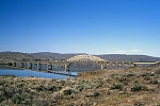
Vantage Bridge
Encyclopedia
The Vantage Bridge is a bridge
in the U.S. state
of Washington. It carries Interstate 90
across the Columbia River
, near Vantage
and George, Washington
. This section of the river is named Wanapum Lake; it is the reservoir formed by Wanapum Dam
. The bridge separates the Ginkgo Petrified Forest
and Wanapum Recreational Area State Park
on the western bank of the Columbia.
The current bridge is the second Vantage Bridge. The first was built in 1927 as part of the Sunset Highway (later US 10
), a precursor to I-90. In 1962 the second bridge was built because the reservoir pool backing up behind the new Wanapum Dam
would soon overwhelm the old bridge. The first bridge was dismantled. In 1968 its steel cantilever truss was reused for the Lyons Ferry Bridge, where SR 261
crosses the Snake River.
Bridge
A bridge is a structure built to span physical obstacles such as a body of water, valley, or road, for the purpose of providing passage over the obstacle...
in the U.S. state
U.S. state
A U.S. state is any one of the 50 federated states of the United States of America that share sovereignty with the federal government. Because of this shared sovereignty, an American is a citizen both of the federal entity and of his or her state of domicile. Four states use the official title of...
of Washington. It carries Interstate 90
Interstate 90
Interstate 90 is the longest Interstate Highway in the United States at . It is the northernmost coast-to-coast interstate, and parallels US 20 for the most part. Its western terminus is in Seattle, at Edgar Martinez Drive S. near Safeco Field and CenturyLink Field, and its eastern terminus is in...
across the Columbia River
Columbia River
The Columbia River is the largest river in the Pacific Northwest region of North America. The river rises in the Rocky Mountains of British Columbia, Canada, flows northwest and then south into the U.S. state of Washington, then turns west to form most of the border between Washington and the state...
, near Vantage
Vantage, Washington
Vantage is a census-designated place in Kittitas County, Washington, United States. The population was 70 at the 2000 census.-History:The area around Vantage has been occupied by the Wanapum Native Americans since prehistory. A number of well-preserved rock-paintings have been found on the cliff...
and George, Washington
George, Washington
George is a city in Grant County, Washington, United States. The population was 528 at the 2000 census. Its name is a play on the name of George Washington.The city is known for being near the Gorge Amphitheatre, sometimes being called, "The Gorge at George"....
. This section of the river is named Wanapum Lake; it is the reservoir formed by Wanapum Dam
Wanapum Dam
Wanapum Dam is a hydroelectric project located on the Columbia River downstream from Vantage, Washington where Interstate 90 crosses the Columbia from Grant County into Kittitas County. It is owned by the Grant County Public Utility District. Its reservoir is named Lake Wanapum.The dam, and its...
. The bridge separates the Ginkgo Petrified Forest
Ginkgo/Wanapum State Park
Ginkgo Petrified Forest State Park/Wanapum Recreational Area is a state park at Vantage, Washington including 27,000 feet of freshwater shoreline on the Wanapum Reservoir on the Columbia River. Petrified wood was discovered in the region in the early 1930s, which led to creation of the park...
and Wanapum Recreational Area State Park
Ginkgo/Wanapum State Park
Ginkgo Petrified Forest State Park/Wanapum Recreational Area is a state park at Vantage, Washington including 27,000 feet of freshwater shoreline on the Wanapum Reservoir on the Columbia River. Petrified wood was discovered in the region in the early 1930s, which led to creation of the park...
on the western bank of the Columbia.
The current bridge is the second Vantage Bridge. The first was built in 1927 as part of the Sunset Highway (later US 10
U.S. Route 10
U.S. Route 10 is an east–west United States highway formed in 1926. Though it never became the cross-country highway suggested by the "0" as the last digit of its route number, U.S...
), a precursor to I-90. In 1962 the second bridge was built because the reservoir pool backing up behind the new Wanapum Dam
Wanapum Dam
Wanapum Dam is a hydroelectric project located on the Columbia River downstream from Vantage, Washington where Interstate 90 crosses the Columbia from Grant County into Kittitas County. It is owned by the Grant County Public Utility District. Its reservoir is named Lake Wanapum.The dam, and its...
would soon overwhelm the old bridge. The first bridge was dismantled. In 1968 its steel cantilever truss was reused for the Lyons Ferry Bridge, where SR 261
Washington State Route 261
State Route 261 is a state route in the U.S. state of Washington.-Route description:Route 261 begins at U.S. Route 12 near Starbuck. After this, it passes through Starbuck. It travels northwest, passing by Lyons Ferry Park. It then intersects State Route 260 southeast of Washtucna...
crosses the Snake River.