
Interstate 664
Encyclopedia
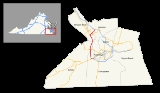
Interstate 664 is an Interstate Highway in the U.S. state of Virginia
. The Interstate runs 20.79 miles (33.5 km) from I-64
and I-264
in Chesapeake
north to I-64 in Hampton
. I-664 forms the west side of the Hampton Roads Beltway
, a circumferential highway
serving the Hampton Roads
metropolitan area. The Interstate crosses Hampton Roads via the Monitor-Merrimac Memorial Bridge-Tunnel
between Suffolk
and Newport News
. I-664 is connected to the other major cities of the metropolitan area—Portsmouth
, Norfolk
, and Virginia Beach
—by I-264. The Interstate also has a connection to Portsmouth through Virginia State Route 164
(SR 164) and to Suffolk via U.S. Route 13
, US 58
, and US 460
.
and Norfolk
. I-664 heads west as an eight-lane freeway that has a southbound-only exit ramp to US 13 and US 460 (Military Highway
) and crosses over Military Highway and a Norfolk Southern Railway
rail line. The Interstate has a cloverleaf interchange
with Military Highway, which here carries US 58 in addition to US 13 and US 460. The interchange also provides access to US 460 Alternate, which follows US 58 east into Portsmouth. I-664 curves north as a four-lane freeway that crosses Goose Creek and has a diamond interchange
with SR 663 (Dock Landing Road) and a cloverleaf interchange with SR 337
(Portsmouth Boulevard).
Just south of its partial cloverleaf interchange with SR 659 (Pughsville Road), I-664 crosses a rail line; a spur from that rail line heads north in the median of the freeway as the highway enters the city of Suffolk. The rail spur leaves the median and heads northeast toward Portsmouth just south of its interchange with SR 164 (Western Freeway) and US 17
(Bridge Road). SR 164 heads east toward downtown Portsmouth while US 17 heads northwest to the James River Bridge
. There is no access from southbound I-664 to southbound US 17; that movement is made via the next interchange, a cloverleaf interchange with SR 135
(College Drive) that serves satellite campuses of Tidewater Community College
and Old Dominion University
and the community of Churchland.
North of SR 135, northbound I-664 has a vehicle inspection station and crossovers before the highway enters the Monitor-Merrimac Memorial Bridge-Tunnel. The bridge-tunnel passes to the west of Craney Island
, an artificial island in the city of Portsmouth that lies to the west of the mouth of the Elizabeth River
. West of the highway is the confluence of the James River
and Nansemond River
to form Hampton Roads, as well as the James River Bridge a short distance to the north on the namesake river. I-664 heads north-northeast along a causeway for 3 miles (4.8 km) to a point west of the Newport News Middle Ground Light
, where the pair of bridges curve to the north-northwest onto an artificial island where the highway descends into a pair of tunnels under the estuary's main shipping channel. The Interstate resurfaces on another artificial island at Newport News Point east of the coal piers in the city of Newport News.
I-664 has a southbound vehicle inspection station adjacent to its first interchange in Newport News, with Terminal Avenue. The Interstate parallels the southern end of CSX
's Peninsula Subdivision as it passes through interchanges with several streets to the east of downtown Newport News. The southern interchange has ramps to and from 25th, 26th, and 27th streets; the first two streets carry eastbound and westbound US 60
, which is unmarked from I-664. The northern interchange has ramps to and from 35th Street and Jefferson Street; Jefferson Street is SR 143
, which is also unmarked from the Interstate. I-664 curves east as a six-lane freeway away from the railroad and has an oblique crossing of SR 351
(39th Street) prior to half-diamond interchanges with Roanoke Avenue and Chestnut Street. The Interstate enters the city of Hampton and has diamond interchanges with Aberdeen Road and Powhatan Parkway before reaching its northern terminus at I-64. I-664 meets its parent highway at a directional T interchange above Newmarket Creek just south of Hampton Coliseum
. The Hampton Roads Beltway continues east along I-64 through Hampton before crossing Hampton Roads on the Hampton Roads Bridge-Tunnel
into the city of Norfolk.
of Chesapeake
, Suffolk
, Newport News
, and Hampton
.
Virginia
The Commonwealth of Virginia , is a U.S. state on the Atlantic Coast of the Southern United States. Virginia is nicknamed the "Old Dominion" and sometimes the "Mother of Presidents" after the eight U.S. presidents born there...
. The Interstate runs 20.79 miles (33.5 km) from I-64
Interstate 64 in Virginia
In the U.S. state of Virginia, Interstate 64 runs east–west through the middle of the state from West Virginia to the Hampton Roads region, a total of . It is notable for crossing the mouth of the harbor of Hampton Roads on the Hampton Roads Bridge-Tunnel, the first bridge-tunnel to...
and I-264
Interstate 264 (Virginia)
Interstate 264 is an Interstate Highway in the U.S. state of Virginia. It runs from a junction with Interstate 64 and Interstate 664 near Bowers Hill in Chesapeake east into Portsmouth and through the Downtown Tunnel under the South Branch of the Elizabeth River into Norfolk...
in Chesapeake
Chesapeake, Virginia
As of the census of 2000, there were 199,184 people, 69,900 households, and 54,172 families residing in the city. The population density was 584.6 people per square mile . There were 72,672 housing units at an average density of 213.3 per square mile...
north to I-64 in Hampton
Hampton, Virginia
Hampton is an independent city that is not part of any county in Southeast Virginia. Its population is 137,436. As one of the seven major cities that compose the Hampton Roads metropolitan area, it is on the southeastern end of the Virginia Peninsula. Located on the Hampton Roads Beltway, it hosts...
. I-664 forms the west side of the Hampton Roads Beltway
Hampton Roads Beltway
The Hampton Roads Beltway is a loop of Interstate 64 and Interstate 664, which links the communities of the Virginia Peninsula and South Hampton Roads which surround the body of water known as Hampton Roads and comprise much of the region of the same name in the southeastern portion of Virginia in...
, a circumferential highway
Ring road
A ring road, orbital motorway, beltway, circumferential highway, or loop highway is a road that encircles a town or city...
serving the Hampton Roads
Hampton Roads
Hampton Roads is the name for both a body of water and the Norfolk–Virginia Beach metropolitan area which surrounds it in southeastern Virginia, United States...
metropolitan area. The Interstate crosses Hampton Roads via the Monitor-Merrimac Memorial Bridge-Tunnel
Monitor-Merrimac Memorial Bridge-Tunnel
Monitor-Merrimac Memorial Bridge-Tunnel is the 4.6 mile-long Hampton Roads crossing for Interstate 664 in the southeastern portion of Virginia in the United States...
between Suffolk
Suffolk, Virginia
Suffolk is the largest city by area in Virginia, United States, and is located in the Hampton Roads metropolitan area. As of the 2010 census, the city had a total population of 84,585. Its median household income was $57,546.-History:...
and Newport News
Newport News, Virginia
Newport News is an independent city located in the Hampton Roads metropolitan area of Virginia. It is at the southeastern end of the Virginia Peninsula, on the north shore of the James River extending southeast from Skiffe's Creek along many miles of waterfront to the river's mouth at Newport News...
. I-664 is connected to the other major cities of the metropolitan area—Portsmouth
Portsmouth, Virginia
Portsmouth is located in the Hampton Roads metropolitan area of the U.S. Commonwealth of Virginia. As of 2010, the city had a total population of 95,535.The Norfolk Naval Shipyard, often called the Norfolk Navy Yard, is a historic and active U.S...
, Norfolk
Norfolk, Virginia
Norfolk is an independent city in the Commonwealth of Virginia in the United States. With a population of 242,803 as of the 2010 Census, it is Virginia's second-largest city behind neighboring Virginia Beach....
, and Virginia Beach
Virginia Beach, Virginia
Virginia Beach is an independent city located in the Hampton Roads metropolitan area of Virginia, on the Atlantic Ocean at the mouth of the Chesapeake Bay...
—by I-264. The Interstate also has a connection to Portsmouth through Virginia State Route 164
Virginia State Route 164
Virginia State Route 164 is a primary state highway in the U.S. state of Virginia. Known as the Western Freeway, the state highway runs from U.S. Route 17 in Suffolk east to US 58 in Portsmouth...
(SR 164) and to Suffolk via U.S. Route 13
U.S. Route 13 in Virginia
U.S. Route 13 is a north–south U.S. highway established in 1926 that runs for from Interstate 95 just north of Fayetteville, North Carolina to the northeastern suburbs of Philadelphia, Pennsylvania, in Morrisville. In the U.S...
, US 58
U.S. Route 58
U.S. Route 58 is an east–west U.S. Highway that runs for from U.S. Route 25E just northwest of Harrogate, Tennessee to U.S. Route 60 in Virginia Beach, Virginia. Until 1996, when the Cumberland Gap Tunnel opened, US 58 ran only inside the commonwealth of Virginia...
, and US 460
U.S. Route 460 in Virginia
U.S. Route 460 in Virginia runs east–west through the southern part of the state. It has two separate pieces in Virginia, joined by a relatively short section in West Virginia...
.
Route description
I-664 begins at a full Y interchange with I-64 and I-264 that serves as the terminus of all three Interstates in the Bowers Hill section of the city of Chesapeake. I-64 heads southeast as a continuation of the Hampton Roads Beltway through Chesapeake while I-264 heads east toward PortsmouthPortsmouth, Virginia
Portsmouth is located in the Hampton Roads metropolitan area of the U.S. Commonwealth of Virginia. As of 2010, the city had a total population of 95,535.The Norfolk Naval Shipyard, often called the Norfolk Navy Yard, is a historic and active U.S...
and Norfolk
Norfolk, Virginia
Norfolk is an independent city in the Commonwealth of Virginia in the United States. With a population of 242,803 as of the 2010 Census, it is Virginia's second-largest city behind neighboring Virginia Beach....
. I-664 heads west as an eight-lane freeway that has a southbound-only exit ramp to US 13 and US 460 (Military Highway
Military Highway
Military Highway is a four-lane roadway built in the South Hampton Roads region of eastern Virginia, USA during World War II.- Original construction :...
) and crosses over Military Highway and a Norfolk Southern Railway
Norfolk Southern Railway
The Norfolk Southern Railway is a Class I railroad in the United States, owned by the Norfolk Southern Corporation. With headquarters in Norfolk, Virginia, the company operates 21,500 route miles in 22 eastern states, the District of Columbia and the province of Ontario, Canada...
rail line. The Interstate has a cloverleaf interchange
Cloverleaf interchange
A cloverleaf interchange is a two-level interchange in which left turns, reverse direction in left-driving regions, are handled by ramp roads...
with Military Highway, which here carries US 58 in addition to US 13 and US 460. The interchange also provides access to US 460 Alternate, which follows US 58 east into Portsmouth. I-664 curves north as a four-lane freeway that crosses Goose Creek and has a diamond interchange
Diamond interchange
A diamond interchange is a common type of road junction, used where a freeway crosses a minor road. The freeway itself is grade-separated from the minor road, one crossing the other over a bridge...
with SR 663 (Dock Landing Road) and a cloverleaf interchange with SR 337
Virginia State Route 337
State Route 337 is a primary state highway in the South Hampton Roads area of the U.S. state of Virginia. It runs east from Suffolk to Portsmouth, where it dead-ends at the decommissioned Jordan Bridge...
(Portsmouth Boulevard).
Just south of its partial cloverleaf interchange with SR 659 (Pughsville Road), I-664 crosses a rail line; a spur from that rail line heads north in the median of the freeway as the highway enters the city of Suffolk. The rail spur leaves the median and heads northeast toward Portsmouth just south of its interchange with SR 164 (Western Freeway) and US 17
U.S. Route 17 in Virginia
U.S. Route 17 is a part of the U.S. Highway System that runs from Punta Gorda, Florida to Winchester, Virginia. In Virginia, the U.S. Highway runs from the North Carolina state line in Chesapeake north to its northern terminus at US 11, US 50, and US 522 in Winchester. US 17 is a major highway...
(Bridge Road). SR 164 heads east toward downtown Portsmouth while US 17 heads northwest to the James River Bridge
James River Bridge
The James River Bridge is a four-lane divided highway lift bridge across the James River in the U.S. state of Virginia. Owned and operated by the Virginia Department of Transportation, it carries U.S. Route 17, U.S. Route 258, and State Route 32 across the river near its mouth at Hampton Roads...
. There is no access from southbound I-664 to southbound US 17; that movement is made via the next interchange, a cloverleaf interchange with SR 135
Virginia State Route 135
Virginia State Route 135 is a primary state highway in the U.S. state of Virginia. Known as College Drive, the state highway runs from U.S. Route 17 north to the entrance of Tidewater Community College, where the highway continues as SR 367, within the independent city of Suffolk...
(College Drive) that serves satellite campuses of Tidewater Community College
Tidewater Community College
Tidewater Community College is a two-year higher education institution in South Hampton Roads with campuses in Chesapeake, Norfolk, Portsmouth, and Virginia Beach — and serving approximately 46,000 students. The school is known locally by its abbreviation, TCC.-History:The school was founded...
and Old Dominion University
Old Dominion University
Old Dominion University is a state university located in Norfolk, Virginia, United States, and is accredited by the Southern Association of Colleges and Schools...
and the community of Churchland.
North of SR 135, northbound I-664 has a vehicle inspection station and crossovers before the highway enters the Monitor-Merrimac Memorial Bridge-Tunnel. The bridge-tunnel passes to the west of Craney Island
Craney Island (Virginia)
Craney Island is a point of land in the independent city of Portsmouth in the South Hampton Roads region of eastern Virginia in the United States. The location, formerly in Norfolk County, is near the mouth of the Elizabeth River opposite Lambert's Point on Hampton Roads. It is managed by the U.S...
, an artificial island in the city of Portsmouth that lies to the west of the mouth of the Elizabeth River
Elizabeth River (Virginia)
The Elizabeth River is a tidal estuary forming an arm of Hampton Roads harbor at the southern end of Chesapeake Bay in southeast Virginia in the United States. It is located along the southern side of the mouth of the James River, between the cities of Portsmouth and Norfolk...
. West of the highway is the confluence of the James River
James River
The James River may refer to:Rivers in the United States and their namesakes* James River * James River , North Dakota, South Dakota* James River * James River * James River...
and Nansemond River
Nansemond River
The Nansemond River is a tributary of the James River in the U.S. state of Virginia. The Nansemond River Bridge crosses the river near its mouth. Both it and the former State Route 125 bridge, demolished in 2008, were once toll bridges. The river begins at the outlet of Lake Meade north of...
to form Hampton Roads, as well as the James River Bridge a short distance to the north on the namesake river. I-664 heads north-northeast along a causeway for 3 miles (4.8 km) to a point west of the Newport News Middle Ground Light
Newport News Middle Ground Light
Newport News Middle Ground Light is a lighthouse near the Monitor-Merrimac Memorial Bridge-Tunnel on Interstate 664 in Hampton Roads. It is the oldest caisson lighthouse in Virginia.-History:...
, where the pair of bridges curve to the north-northwest onto an artificial island where the highway descends into a pair of tunnels under the estuary's main shipping channel. The Interstate resurfaces on another artificial island at Newport News Point east of the coal piers in the city of Newport News.
I-664 has a southbound vehicle inspection station adjacent to its first interchange in Newport News, with Terminal Avenue. The Interstate parallels the southern end of CSX
CSX Transportation
CSX Transportation operates a Class I railroad in the United States known as the CSX Railroad. It is the main subsidiary of the CSX Corporation. The company is headquartered in Jacksonville, Florida, and owns approximately 21,000 route miles...
's Peninsula Subdivision as it passes through interchanges with several streets to the east of downtown Newport News. The southern interchange has ramps to and from 25th, 26th, and 27th streets; the first two streets carry eastbound and westbound US 60
U.S. Route 60 in Virginia
U.S. Route 60 in Virginia runs west to east through the central part of the state, generally close to and paralleling the Interstate 64 corridor, except for the crossing of the Blue Ridge Mountains, and in the South Hampton Roads area....
, which is unmarked from I-664. The northern interchange has ramps to and from 35th Street and Jefferson Street; Jefferson Street is SR 143
Virginia State Route 143
Virginia State Route 143 is a primary state highway in the U.S. state of Virginia. The state highway runs from Camp Peary near Williamsburg east to U.S. Route 258 at Fort Monroe in Hampton. SR 143 is a major local thoroughfare on the Virginia Peninsula portion of the Hampton Roads metropolitan...
, which is also unmarked from the Interstate. I-664 curves east as a six-lane freeway away from the railroad and has an oblique crossing of SR 351
Virginia State Route 351
State Route 351 is a primary state highway in Hampton and Newport News, Virginia, United States. It makes no turns, following 39th Street and Pembroke Avenue from Huntington Avenue northwest of downtown Newport News east to Second Street, one block past State Route 169, in the Buckroe Beach area...
(39th Street) prior to half-diamond interchanges with Roanoke Avenue and Chestnut Street. The Interstate enters the city of Hampton and has diamond interchanges with Aberdeen Road and Powhatan Parkway before reaching its northern terminus at I-64. I-664 meets its parent highway at a directional T interchange above Newmarket Creek just south of Hampton Coliseum
Hampton Coliseum
The Hampton Coliseum is a multi-use cultural, entertainment and sports arena in Hampton, Virginia. Construction on the arena began on May 24, 1968 and the venue opened in 1970 as the first large multi-purpose arena in the Hampton Roads region and the state of Virginia, opening a year prior to...
. The Hampton Roads Beltway continues east along I-64 through Hampton before crossing Hampton Roads on the Hampton Roads Bridge-Tunnel
Hampton Roads Bridge-Tunnel
The Hampton Roads Bridge-Tunnel is the -long Hampton Roads crossing for Interstate 64 and U.S. Route 60. It is a four-lane facility comprising bridges, trestles, man-made islands, and tunnels under the main shipping channels for Hampton Roads harbor in the southeastern portion of Virginia in the...
into the city of Norfolk.
Exit list
The entire route is in the independent citiesIndependent city
An independent city is a city that does not form part of another general-purpose local government entity. These type of cities should not be confused with city-states , which are fully sovereign cities that are not part of any other sovereign state.-Historical precursors:In the Holy Roman Empire,...
of Chesapeake
Chesapeake, Virginia
As of the census of 2000, there were 199,184 people, 69,900 households, and 54,172 families residing in the city. The population density was 584.6 people per square mile . There were 72,672 housing units at an average density of 213.3 per square mile...
, Suffolk
Suffolk, Virginia
Suffolk is the largest city by area in Virginia, United States, and is located in the Hampton Roads metropolitan area. As of the 2010 census, the city had a total population of 84,585. Its median household income was $57,546.-History:...
, Newport News
Newport News, Virginia
Newport News is an independent city located in the Hampton Roads metropolitan area of Virginia. It is at the southeastern end of the Virginia Peninsula, on the north shore of the James River extending southeast from Skiffe's Creek along many miles of waterfront to the river's mouth at Newport News...
, and Hampton
Hampton, Virginia
Hampton is an independent city that is not part of any county in Southeast Virginia. Its population is 137,436. As one of the seven major cities that compose the Hampton Roads metropolitan area, it is on the southeastern end of the Virginia Peninsula. Located on the Hampton Roads Beltway, it hosts...
.