
St. Bernard Parish, Louisiana
Encyclopedia
St. Bernard Parish is a parish
located southeast of New Orleans in the U.S. state
of Louisiana
. The parish seat is Chalmette
, the largest city in the parish. As of 2000, its population was 67,229. It has been ranked the fastest-growing county (parish) in the United States from 2007 to 2008 by the U.S. Census Bureau, but it is only half as populated as it was in 2005. In 2009, because of evacuation and outmigration due to destruction by Hurricane Katrina
, its population was estimated to be 33,439
St. Bernard Parish is part of the New Orleans
–Metairie
–Kenner
Metropolitan Statistical Area
as well as the New Orleans–Metairie–Bogalusa
Combined Statistical Area
.
descent. Sometimes referred to informally as "Spanish Cajuns", the Isleños
are descended from Canary Islanders
who arrived around 1780. This linguistically isolated group eventually developed its own dialect. This settlement was first called La Concepcion and Nueva Galvez by Spanish officials, but was later renamed Terre aux Boeufs (French) and Tierra de Bueyes (Spanish) for "land of cattle", because nearby areas were used for cattle grazing. By the end of the 1780s, St. Bernard, the patron saint of Bernardo de Galvez, was used in documents to identify the area.
The chief historical attraction in St. Bernard Parish is the Chalmette National Historical Park (or Chalmette Battlefield), at which the Battle of New Orleans
took place on January 8, 1815 during the War of 1812
. Many street names near the battlefield bear the names of the chief participants, or take a pirate theme, since the pirate Jean Lafitte
was considered to be a hero in the battle. A high school, later elementary and now a middle school, was named in honor of (then Colonel) Andrew Jackson
, who was the American commanding officer in the battle.
From 1919 to 1969, the parish was effectively ruled as part of the fiefdom of Leander Perez
, a local Democratic official in neighboring Plaquemines Parish
.
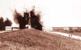
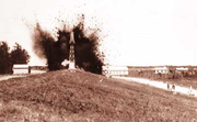 During the Great Mississippi Flood of 1927
, New Orleans city and state leaders used dynamite
to breach a levee
at Caernarvon
, thirteen miles (19 km) below Canal Street, to save the city of New Orleans from flooding. At the time, it was thought by New Orleans residents that the dynamiting saved the city, but historians now believe that the dynamiting was unnecessary due to major upstream levee breaks that relieved pressure on the New Orleans levees. The levee breach caused flooding and widespread destruction in most of Eastern St. Bernard Parish and parts of Plaquemines Parish. Residents were never adequately compensated for their losses.
. The storm damaged virtually every structure in the parish. The eye of Katrina passed over the eastern portion of the parish, pushing a 25 feet (7.6 m) storm surge
into the Mississippi River Gulf Outlet ("MRGO"). This surge destroyed the parish levees. Almost the entire parish was flooded, with most areas left with between 5 and 12 feet (3.7 m) of standing water. The water rose suddenly and violently, during a period which witnesses reported as no more than fifteen minutes. In many areas, houses were smashed or washed off their foundations by a storm surge higher than the roofs.
For more than two months after the storm, much of the parish remained without proper services, including electricity, water, and sewage. Parish President Henry "Junior" Rodriguez, declared all of the parish's homes unlivable. Emergency Communities
offered one reason for hope in the first year after Hurricane Katrina. In the parking lot of a destroyed off-track betting parlor, EC built the Made with Love Cafe and Grill, a free kitchen and community center serving 1500 meals per day. Made with Love, housed in a geodesic dome
, also offered food and clothing distribution, and emotionally supportive volunteers. Upon leaving, EC has offered logistical support for the founding of a new long-term Community Center of St Bernard
http://www.ccstb.org
As of late November 2005, it was estimated that the Parish had some 7,000 full-time residents, with some 20,000 commuting to spend the day working, cleaning up, or salvaging in the parish and spending their nights elsewhere. By mid-December some businesses had returned to the Parish, most notably the ExxonMobil
plant in Chalmette
and the Domino Sugar plant in Arabi
, together with a handful of small local stores and businesses.
At the start of January 2006, it was estimated that some 8,000 people were living in the Parish. The H.O.P.E. Project, a collective of volunteer relief workers, founded itself in January 2006 in the empty shell of the Corinne Missionary Baptist Church in Violet, LA, providing the tools for rebuilding and community empowerment. Since June 2006, Camp Hope
has been housing volunteers' assisting residents of St. Bernard Parish in their recovery from Hurricane Katrina. It is located at 1914 Aycock Street, Arabi, LA, 70032. A grassroots organization, the St. Bernard Project
http://www.stbernardproject.org, opened its doors in March 2006. A fully volunteer-run organization funded by the United Way, they help residents get back into their homes by working on the houses, providing tools, support and where possible, funding.
As of October 2006, the population was estimated to be 25,489 After population losses due to Hurricane Katrina, the school was reopened for elementary grades for the 2006-2007 school year.
The parish of St. Bernard comprises an area of 680 square miles (1,761.2 km²) and embraces numerous small islands. The parish is classed among the alluvial lands of the state. The ridges comprise the arable lands of the parish and have an area of 37,000 acres (150 km²). The principal streams are the Bayous Terre aux Boeufs and La Loutre. There are numerous smaller streams which are efficient drainage canals. The dominant tree species is bald cypress, of which the most valuable trees have been cut and processed.
of 2000, there were 67,229 people (an increase of 598 or 0.9% over the previous decade), 25,123 households, and 18,289 families residing in the parish. The population density
was 145 people per square mile (56/km²). There were 26,790 housing units at an average density of 58 per square mile (22/km²). The racial makeup of the parish was 88.29% White
, 7.62% Black
or African American
, 0.49% Native American
, 1.32% Asian
, 0.02% Pacific Islander
, 0.73% from other races
, and 1.52% from two or more races. 5.09% of the population were Hispanic
or Latino
of any race.
There were 25,123 households out of which 33.70% had children under the age of 18 living with them, 53.40% were married couples
living together, 14.60% had a female householder with no husband present, and 27.20% were non-families. 22.90% of all households were made up of individuals and 10.10% had someone living alone who was 65 years of age or older. The average household size was 2.64 and the average family size was 3.12.
In the parish the population was spread out with 25.20% under the age of 18, 9.20% from 18 to 24, 29.20% from 25 to 44, 22.60% from 45 to 64, and 13.80% who were 65 years of age or older. The median age was 37 years. For every 100 females there were 93.60 males. For every 100 females age 18 and over, there were 90.10 males.
The median income for a household in the parish was $35,939, and the median income for a family was $42,785. Males had a median income of $34,303 versus $24,009 for females. The per capita income
for the parish was $16,718. About 10.50% of families and 13.10% of the population were below the poverty line, including 16.50% of those under age 18 and 11.40% of those age 65 or over.
As of the census of 2010, there are 35,897 people. The racial makeup of the parish was 26,579 whites, 6,350 blacks, 690 Asians, 260 Native American, and the rest of any other race.
 There are no incorporated areas in St. Bernard Parish.
agency.
Due to Hurricane Katrina, the parish's 20 plus public schools had been consolidated as one school, the St. Bernard Unified School
, or SBUS. Starting in the 2006-2007 school year, the St. Bernard Unified School will break up into several different schools.
The parish is served by Nunez Community College
.
As of 2011, the Public School System has expanded. Andrew Jackson High School was converted into an Elementary School. Lacoste Elementary has been converted into a Ninth Grade Academy. Trist Middle School is once again serving as a Middle School. If there are anymore, please add them.
Parish (subnational entity)
A parish is an administrative division used by several countries. In the British Isles it is known as a civil parish to distinguish it from the ecclesiastical parish.-External links:* Editorial in The Guardian, 2011-05-16....
located southeast of New Orleans in the U.S. state
U.S. state
A U.S. state is any one of the 50 federated states of the United States of America that share sovereignty with the federal government. Because of this shared sovereignty, an American is a citizen both of the federal entity and of his or her state of domicile. Four states use the official title of...
of Louisiana
Louisiana
Louisiana is a state located in the southern region of the United States of America. Its capital is Baton Rouge and largest city is New Orleans. Louisiana is the only state in the U.S. with political subdivisions termed parishes, which are local governments equivalent to counties...
. The parish seat is Chalmette
Chalmette, Louisiana
Chalmette is a census-designated place in and the parish seat of St. Bernard Parish, Louisiana, United States. The population was 32,069 at the 2000 census. It is part of the New Orleans–Metairie–Kenner Metropolitan Statistical Area...
, the largest city in the parish. As of 2000, its population was 67,229. It has been ranked the fastest-growing county (parish) in the United States from 2007 to 2008 by the U.S. Census Bureau, but it is only half as populated as it was in 2005. In 2009, because of evacuation and outmigration due to destruction by Hurricane Katrina
Hurricane Katrina
Hurricane Katrina of the 2005 Atlantic hurricane season was a powerful Atlantic hurricane. It is the costliest natural disaster, as well as one of the five deadliest hurricanes, in the history of the United States. Among recorded Atlantic hurricanes, it was the sixth strongest overall...
, its population was estimated to be 33,439
St. Bernard Parish is part of the New Orleans
New Orleans, Louisiana
New Orleans is a major United States port and the largest city and metropolitan area in the state of Louisiana. The New Orleans metropolitan area has a population of 1,235,650 as of 2009, the 46th largest in the USA. The New Orleans – Metairie – Bogalusa combined statistical area has a population...
–Metairie
Metairie, Louisiana
Metairie is a census-designated place in Jefferson Parish, Louisiana, United States and is a major part of the New Orleans Metropolitan Area. Metairie is the largest community in Jefferson Parish. It is an unincorporated area that would be larger than most of the state's cities if it were...
–Kenner
Kenner, Louisiana
Kenner is a city in Jefferson Parish, Louisiana, United States, and a suburb of New Orleans. The population was 66,702 at the 2010 census....
Metropolitan Statistical Area
New Orleans metropolitan area
New Orleans–Metairie–Kenner, or the Greater New Orleans Region is a metropolitan area designated by the United States Census encompassing seven parishes in the state of Louisiana, centering on the city of New Orleans...
as well as the New Orleans–Metairie–Bogalusa
Bogalusa, Louisiana
Bogalusa is a city in Washington Parish, Louisiana, United States. The population was 13,365 at the 2000 census. It is the principal city of the Bogalusa Micropolitan Statistical Area, which includes all of Washington Parish and is also part of the larger New Orleans–Metairie–Bogalusa...
Combined Statistical Area
New Orleans-Metairie-Bogalusa combined statistical area
The New Orleans–Metairie–Bogalusa Combined Statistical Area is made up of eight parishes in southeastern Louisiana. The statistical area consists of the New Orleans Metropolitan Statistical Area and the Bogalusa Micropolitan Statistical Area...
.
History
St. Bernard Parish contains a small community of SpanishSpain
Spain , officially the Kingdom of Spain languages]] under the European Charter for Regional or Minority Languages. In each of these, Spain's official name is as follows:;;;;;;), is a country and member state of the European Union located in southwestern Europe on the Iberian Peninsula...
descent. Sometimes referred to informally as "Spanish Cajuns", the Isleños
Isleños
Isleño is the Spanish word meaning "islander." The Isleños are the descendants of Canary Island immigrants to Louisiana, Cuba, Venezuela, Puerto Rico and other parts of the Americas....
are descended from Canary Islanders
Canary Islands
The Canary Islands , also known as the Canaries , is a Spanish archipelago located just off the northwest coast of mainland Africa, 100 km west of the border between Morocco and the Western Sahara. The Canaries are a Spanish autonomous community and an outermost region of the European Union...
who arrived around 1780. This linguistically isolated group eventually developed its own dialect. This settlement was first called La Concepcion and Nueva Galvez by Spanish officials, but was later renamed Terre aux Boeufs (French) and Tierra de Bueyes (Spanish) for "land of cattle", because nearby areas were used for cattle grazing. By the end of the 1780s, St. Bernard, the patron saint of Bernardo de Galvez, was used in documents to identify the area.
The chief historical attraction in St. Bernard Parish is the Chalmette National Historical Park (or Chalmette Battlefield), at which the Battle of New Orleans
Battle of New Orleans
The Battle of New Orleans took place on January 8, 1815 and was the final major battle of the War of 1812. American forces, commanded by Major General Andrew Jackson, defeated an invading British Army intent on seizing New Orleans and the vast territory the United States had acquired with the...
took place on January 8, 1815 during the War of 1812
War of 1812
The War of 1812 was a military conflict fought between the forces of the United States of America and those of the British Empire. The Americans declared war in 1812 for several reasons, including trade restrictions because of Britain's ongoing war with France, impressment of American merchant...
. Many street names near the battlefield bear the names of the chief participants, or take a pirate theme, since the pirate Jean Lafitte
Jean Lafitte
Jean Lafitte was a pirate and privateer in the Gulf of Mexico in the early 19th century. He and his elder brother, Pierre, spelled their last name Laffite, but English-language documents of the time used "Lafitte", and this is the commonly seen spelling in the United States, including for places...
was considered to be a hero in the battle. A high school, later elementary and now a middle school, was named in honor of (then Colonel) Andrew Jackson
Andrew Jackson
Andrew Jackson was the seventh President of the United States . Based in frontier Tennessee, Jackson was a politician and army general who defeated the Creek Indians at the Battle of Horseshoe Bend , and the British at the Battle of New Orleans...
, who was the American commanding officer in the battle.
From 1919 to 1969, the parish was effectively ruled as part of the fiefdom of Leander Perez
Leander Perez
Leander Henry Perez, Sr. , was the Democratic political boss of Plaquemines and St. Bernard parishes in southeastern Louisiana during the middle third of the 20th century. Officially, he served as a district judge, later as district attorney, and as president of the Plaquemines Parish Commission...
, a local Democratic official in neighboring Plaquemines Parish
Plaquemines Parish, Louisiana
Plaquemines Parish is the parish with the most combined land and water area in the U.S. state of Louisiana. The parish seat is Pointe à la Hache...
.
Great Mississippi Flood of 1927
The Great Mississippi Flood of 1927 was the most destructive river flood in the history of the United States.-Events:The flood began when heavy rains pounded the central basin of the Mississippi in the summer of 1926. By September, the Mississippi's tributaries in Kansas and Iowa were swollen to...
, New Orleans city and state leaders used dynamite
Dynamite
Dynamite is an explosive material based on nitroglycerin, initially using diatomaceous earth , or another absorbent substance such as powdered shells, clay, sawdust, or wood pulp. Dynamites using organic materials such as sawdust are less stable and such use has been generally discontinued...
to breach a levee
Levee
A levee, levée, dike , embankment, floodbank or stopbank is an elongated naturally occurring ridge or artificially constructed fill or wall, which regulates water levels...
at Caernarvon
Caernarvon, Louisiana
Caernarvon is an unincorporated community in St. Bernard Parish, Louisiana, United States. The name of the community is from a plantation originally located here. The plantation's name is widely believed to be from a similarly named town in Wales.-History:...
, thirteen miles (19 km) below Canal Street, to save the city of New Orleans from flooding. At the time, it was thought by New Orleans residents that the dynamiting saved the city, but historians now believe that the dynamiting was unnecessary due to major upstream levee breaks that relieved pressure on the New Orleans levees. The levee breach caused flooding and widespread destruction in most of Eastern St. Bernard Parish and parts of Plaquemines Parish. Residents were never adequately compensated for their losses.
Hurricane Katrina and its aftermath
On August 29, 2005, St. Bernard was devastated by Hurricane KatrinaHurricane Katrina
Hurricane Katrina of the 2005 Atlantic hurricane season was a powerful Atlantic hurricane. It is the costliest natural disaster, as well as one of the five deadliest hurricanes, in the history of the United States. Among recorded Atlantic hurricanes, it was the sixth strongest overall...
. The storm damaged virtually every structure in the parish. The eye of Katrina passed over the eastern portion of the parish, pushing a 25 feet (7.6 m) storm surge
Storm surge
A storm surge is an offshore rise of water associated with a low pressure weather system, typically tropical cyclones and strong extratropical cyclones. Storm surges are caused primarily by high winds pushing on the ocean's surface. The wind causes the water to pile up higher than the ordinary sea...
into the Mississippi River Gulf Outlet ("MRGO"). This surge destroyed the parish levees. Almost the entire parish was flooded, with most areas left with between 5 and 12 feet (3.7 m) of standing water. The water rose suddenly and violently, during a period which witnesses reported as no more than fifteen minutes. In many areas, houses were smashed or washed off their foundations by a storm surge higher than the roofs.
For more than two months after the storm, much of the parish remained without proper services, including electricity, water, and sewage. Parish President Henry "Junior" Rodriguez, declared all of the parish's homes unlivable. Emergency Communities
Emergency Communities
Emergency Communities was a volunteer organization which formed after Hurricane Katrina in 2005. It provided meals and other relief to residents and emergency responders, first in Mississippi, then in Louisiana. Emergency Communities ran sites in St. Bernard Parish, Plaquemines Parish, and Orleans...
offered one reason for hope in the first year after Hurricane Katrina. In the parking lot of a destroyed off-track betting parlor, EC built the Made with Love Cafe and Grill, a free kitchen and community center serving 1500 meals per day. Made with Love, housed in a geodesic dome
Geodesic dome
A geodesic dome is a spherical or partial-spherical shell structure or lattice shell based on a network of great circles on the surface of a sphere. The geodesics intersect to form triangular elements that have local triangular rigidity and also distribute the stress across the structure. When...
, also offered food and clothing distribution, and emotionally supportive volunteers. Upon leaving, EC has offered logistical support for the founding of a new long-term Community Center of St Bernard
Community Center of St Bernard
The Community Center of St Bernard a 501 nonprofit organization is located in Arabi, Louisiana, in St Bernard Parish near New Orleans. The Community Center was founded in 2006 to serve local residents after the overwhelming devastation caused by Hurricane Katrina and Hurricane Rita...
http://www.ccstb.org
As of late November 2005, it was estimated that the Parish had some 7,000 full-time residents, with some 20,000 commuting to spend the day working, cleaning up, or salvaging in the parish and spending their nights elsewhere. By mid-December some businesses had returned to the Parish, most notably the ExxonMobil
ExxonMobil
Exxon Mobil Corporation or ExxonMobil, is an American multinational oil and gas corporation. It is a direct descendant of John D. Rockefeller's Standard Oil company, and was formed on November 30, 1999, by the merger of Exxon and Mobil. Its headquarters are in Irving, Texas...
plant in Chalmette
Chalmette, Louisiana
Chalmette is a census-designated place in and the parish seat of St. Bernard Parish, Louisiana, United States. The population was 32,069 at the 2000 census. It is part of the New Orleans–Metairie–Kenner Metropolitan Statistical Area...
and the Domino Sugar plant in Arabi
Arabi, Louisiana
Arabi is a census-designated place in St. Bernard Parish, Louisiana on the East Bank of the Mississippi River, between the Lower 9th Ward of New Orleans, Louisiana and Chalmette within the Greater New Orleans Metropolitan area...
, together with a handful of small local stores and businesses.
At the start of January 2006, it was estimated that some 8,000 people were living in the Parish. The H.O.P.E. Project, a collective of volunteer relief workers, founded itself in January 2006 in the empty shell of the Corinne Missionary Baptist Church in Violet, LA, providing the tools for rebuilding and community empowerment. Since June 2006, Camp Hope
Camp Hope
Camp Hope , is a volunteer base camp located in a former school in St. Bernard Parish, Louisiana. Camp Hope has welcomed people from all over the United States and all over the world who have come to participate in the massive recovery efforts of St...
has been housing volunteers' assisting residents of St. Bernard Parish in their recovery from Hurricane Katrina. It is located at 1914 Aycock Street, Arabi, LA, 70032. A grassroots organization, the St. Bernard Project
St. Bernard Project
The St. Bernard Project is a non-profit organization established in March 2006 to rebuild homes destroyed by Hurricane Katrina within the St. Bernard Parish. It was originally founded by Zack Rosenburg and Liz McCartney. As of June 2011, the St...
http://www.stbernardproject.org, opened its doors in March 2006. A fully volunteer-run organization funded by the United Way, they help residents get back into their homes by working on the houses, providing tools, support and where possible, funding.
As of October 2006, the population was estimated to be 25,489 After population losses due to Hurricane Katrina, the school was reopened for elementary grades for the 2006-2007 school year.
Geography
The parish has a total area of 1,794 square miles (4,646 km²). 465 square miles (1,204 km²) of it is land and, at 1,329 square miles (3,441 km²) water. At 74.07% water, St. Bernard has the largest percentage of area in water of any parish in Louisiana.The parish of St. Bernard comprises an area of 680 square miles (1,761.2 km²) and embraces numerous small islands. The parish is classed among the alluvial lands of the state. The ridges comprise the arable lands of the parish and have an area of 37,000 acres (150 km²). The principal streams are the Bayous Terre aux Boeufs and La Loutre. There are numerous smaller streams which are efficient drainage canals. The dominant tree species is bald cypress, of which the most valuable trees have been cut and processed.
Major highways
 Louisiana Highway 39Louisiana Highway 39Louisiana Highway 39 is a state highway in Louisiana that serves Orleans, St. Bernard, and Plaquemines Parishes. In New Orleans, LA 39 is referred to as North Claiborne Avenue, while in St. Bernard Parish, it is known as Judge Perez Drive...
 Louisiana Highway 46Louisiana Highway 46Louisiana Highway 46 is a state highway in Louisiana that serves Orleans and St. Bernard Parishes. It runs a west to east direction for a total length of . It is demarcated as Elysian Fields Avenue and St. Claude Avenue in the city of New Orleans and as St. Bernard Highway, Bayou Road, East Judge...
 Louisiana Highway 47Louisiana Highway 47Louisiana Highway 47 is a state highway in Louisiana that serves Orleans and St. Bernard Parishes. It spans 16.19 in a southeast to northwest direction, although it is designated as a south/north route. It is known locally as Paris Road and Hayne Boulevard.-Route description:From the south, LA 47...
Adjacent parishes and features
- Lake BorgneLake BorgneLake Borgne is a lagoon in eastern Louisiana of the Gulf of Mexico. Due to coastal erosion, it is no longer actually a lake but rather an arm of the Gulf of Mexico. Its name comes from the French word borgne, which means "one-eyed".-Geography:...
(north) - Mississippi RiverMississippi RiverThe Mississippi River is the largest river system in North America. Flowing entirely in the United States, this river rises in western Minnesota and meanders slowly southwards for to the Mississippi River Delta at the Gulf of Mexico. With its many tributaries, the Mississippi's watershed drains...
(south & west) - Gulf of MexicoGulf of MexicoThe Gulf of Mexico is a partially landlocked ocean basin largely surrounded by the North American continent and the island of Cuba. It is bounded on the northeast, north and northwest by the Gulf Coast of the United States, on the southwest and south by Mexico, and on the southeast by Cuba. In...
(east)- Hancock CountyHancock County, Mississippi-Demographics:As of the census of 2000, there were 42,967 people, 16,897 households, and 11,827 families residing in the county. The population density was 90 people per square mile . There were 21,072 housing units at an average density of 44 per square mile...
, MississippiMississippiMississippi is a U.S. state located in the Southern United States. Jackson is the state capital and largest city. The name of the state derives from the Mississippi River, which flows along its western boundary, whose name comes from the Ojibwe word misi-ziibi...
(water border) - Harrison CountyHarrison County, Mississippi-National protected areas:* De Soto National Forest * Gulf Islands National Seashore - Demographics :As of the census of 2000, there were 189,601 people, 71,538 households, and 48,574 families residing in the county. The population density was 326 people per square mile . There were 79,636 housing...
, MississippiMississippiMississippi is a U.S. state located in the Southern United States. Jackson is the state capital and largest city. The name of the state derives from the Mississippi River, which flows along its western boundary, whose name comes from the Ojibwe word misi-ziibi...
(water border)
- Hancock County
- Plaquemines ParishPlaquemines Parish, LouisianaPlaquemines Parish is the parish with the most combined land and water area in the U.S. state of Louisiana. The parish seat is Pointe à la Hache...
(south) - Orleans Parish (west & northwest)
National protected areas
- Breton National Wildlife RefugeBreton National Wildlife RefugeBreton National Wildlife Refuge is located in southeastern Louisiana in the offshore Breton Islands and Chandeleur Islands. It is located in the Gulf of Mexico and is accessible only by boat...
(part) - Jean Lafitte National Historical Park (part, in ChalmetteChalmette, LouisianaChalmette is a census-designated place in and the parish seat of St. Bernard Parish, Louisiana, United States. The population was 32,069 at the 2000 census. It is part of the New Orleans–Metairie–Kenner Metropolitan Statistical Area...
)
Demographics
As of the censusCensus
A census is the procedure of systematically acquiring and recording information about the members of a given population. It is a regularly occurring and official count of a particular population. The term is used mostly in connection with national population and housing censuses; other common...
of 2000, there were 67,229 people (an increase of 598 or 0.9% over the previous decade), 25,123 households, and 18,289 families residing in the parish. The population density
Population density
Population density is a measurement of population per unit area or unit volume. It is frequently applied to living organisms, and particularly to humans...
was 145 people per square mile (56/km²). There were 26,790 housing units at an average density of 58 per square mile (22/km²). The racial makeup of the parish was 88.29% White
Race (United States Census)
Race and ethnicity in the United States Census, as defined by the Federal Office of Management and Budget and the United States Census Bureau, are self-identification data items in which residents choose the race or races with which they most closely identify, and indicate whether or not they are...
, 7.62% Black
Race (United States Census)
Race and ethnicity in the United States Census, as defined by the Federal Office of Management and Budget and the United States Census Bureau, are self-identification data items in which residents choose the race or races with which they most closely identify, and indicate whether or not they are...
or African American
Race (United States Census)
Race and ethnicity in the United States Census, as defined by the Federal Office of Management and Budget and the United States Census Bureau, are self-identification data items in which residents choose the race or races with which they most closely identify, and indicate whether or not they are...
, 0.49% Native American
Race (United States Census)
Race and ethnicity in the United States Census, as defined by the Federal Office of Management and Budget and the United States Census Bureau, are self-identification data items in which residents choose the race or races with which they most closely identify, and indicate whether or not they are...
, 1.32% Asian
Race (United States Census)
Race and ethnicity in the United States Census, as defined by the Federal Office of Management and Budget and the United States Census Bureau, are self-identification data items in which residents choose the race or races with which they most closely identify, and indicate whether or not they are...
, 0.02% Pacific Islander
Race (United States Census)
Race and ethnicity in the United States Census, as defined by the Federal Office of Management and Budget and the United States Census Bureau, are self-identification data items in which residents choose the race or races with which they most closely identify, and indicate whether or not they are...
, 0.73% from other races
Race (United States Census)
Race and ethnicity in the United States Census, as defined by the Federal Office of Management and Budget and the United States Census Bureau, are self-identification data items in which residents choose the race or races with which they most closely identify, and indicate whether or not they are...
, and 1.52% from two or more races. 5.09% of the population were Hispanic
Race (United States Census)
Race and ethnicity in the United States Census, as defined by the Federal Office of Management and Budget and the United States Census Bureau, are self-identification data items in which residents choose the race or races with which they most closely identify, and indicate whether or not they are...
or Latino
Race (United States Census)
Race and ethnicity in the United States Census, as defined by the Federal Office of Management and Budget and the United States Census Bureau, are self-identification data items in which residents choose the race or races with which they most closely identify, and indicate whether or not they are...
of any race.
There were 25,123 households out of which 33.70% had children under the age of 18 living with them, 53.40% were married couples
Marriage
Marriage is a social union or legal contract between people that creates kinship. It is an institution in which interpersonal relationships, usually intimate and sexual, are acknowledged in a variety of ways, depending on the culture or subculture in which it is found...
living together, 14.60% had a female householder with no husband present, and 27.20% were non-families. 22.90% of all households were made up of individuals and 10.10% had someone living alone who was 65 years of age or older. The average household size was 2.64 and the average family size was 3.12.
In the parish the population was spread out with 25.20% under the age of 18, 9.20% from 18 to 24, 29.20% from 25 to 44, 22.60% from 45 to 64, and 13.80% who were 65 years of age or older. The median age was 37 years. For every 100 females there were 93.60 males. For every 100 females age 18 and over, there were 90.10 males.
The median income for a household in the parish was $35,939, and the median income for a family was $42,785. Males had a median income of $34,303 versus $24,009 for females. The per capita income
Per capita income
Per capita income or income per person is a measure of mean income within an economic aggregate, such as a country or city. It is calculated by taking a measure of all sources of income in the aggregate and dividing it by the total population...
for the parish was $16,718. About 10.50% of families and 13.10% of the population were below the poverty line, including 16.50% of those under age 18 and 11.40% of those age 65 or over.
As of the census of 2010, there are 35,897 people. The racial makeup of the parish was 26,579 whites, 6,350 blacks, 690 Asians, 260 Native American, and the rest of any other race.
Communities
- Greater New Orleans
- ArabiArabi, LouisianaArabi is a census-designated place in St. Bernard Parish, Louisiana on the East Bank of the Mississippi River, between the Lower 9th Ward of New Orleans, Louisiana and Chalmette within the Greater New Orleans Metropolitan area...
- ChalmetteChalmette, LouisianaChalmette is a census-designated place in and the parish seat of St. Bernard Parish, Louisiana, United States. The population was 32,069 at the 2000 census. It is part of the New Orleans–Metairie–Kenner Metropolitan Statistical Area...
– parish seat and parish's population center- VersaillesVersailles, LouisianaVersailles is a community in Saint Bernard Parish, Louisiana. It is along the East Bank of the Mississippi River, about 3.5 miles below the lower limit of New Orleans. The community, for governmental and postal address purposes, is considered part of Chalmette and by some designations, part of...
- Versailles
- MerauxMeraux, LouisianaMeraux is a census-designated place in St. Bernard Parish, Louisiana, in the United States. The population was 10,192 at the 2000 census...
- VioletViolet, LouisianaViolet is a census-designated place in St. Bernard Parish, Louisiana, United States. The population was 8,555 at the 2000 census. Violet is located on the east bank of the Mississippi River, about southeast of New Orleans and is part of the New Orleans–Metairie–Kenner Metropolitan...
- Arabi
- Eastern St. Bernard
- CaernarvonCaernarvon, LouisianaCaernarvon is an unincorporated community in St. Bernard Parish, Louisiana, United States. The name of the community is from a plantation originally located here. The plantation's name is widely believed to be from a similarly named town in Wales.-History:...
- Contreras
- Delacroix IslandDelacroix Island, LouisianaDelacroix Island or Delacroix is an unincorporated town in St. Bernard Parish, Louisiana, United States.-History:In the 1780s, Spanish Canary Islanders, or Isleños, settled in the area after being given land grants from Spain. After selling their land grants to the planters, the Isleños frequently...
- HopedaleHopedale, LouisianaHopedale is an unincorporated community in Louisiana. It is located in Saint Bernard Parish, in the metropolitan New Orleans.The latitude of Hopedale is 29.820N. The longitude is-89.656W. It is in the Central Standard time zone. The elevation is 3 feet....
- Kenilworth
- PoydrasPoydras, LouisianaPoydras is a census-designated place in St. Bernard Parish, Louisiana, United States. The population was 3,886 at the 2000 census. It is part of the New Orleans–Metairie–Kenner Metropolitan Statistical Area...
- Reggio
- St.Bernard Village
- Shell Beach
- Toca
- Verret
- Yscloskey
- Caernarvon
Historical
- FazendevilleFazendeville, LouisianaFazendeville was a small community in Saint Bernard Parish, Louisiana which was dismantled in the 1960s.Fazendeville was located on land that had been a portion of the battlefield of The Battle of New Orleans, between the Chalmette National Cemetery and the Chalmette monument.In 1854 the land was...
- Proctorville
- St. MaloSaint Malo, LouisianaSaint Malo was a small fishing village that existed in St. Bernard Parish, Louisiana on the shore of Lake Borgne from the mid 18th century into the early 20th century, when it was destroyed by the New Orleans Hurricane of 1915. It was the first settlement of Filipinos in the United...
Education
Public schools in the parish are operated by the St. Bernard Parish Public SchoolsSt. Bernard Parish Public Schools
St. Bernard Parish Public Schools is a school district headquartered in unincorporated St. Bernard Parish, Louisiana, United States. The district operates public schools in the parish.-Schools:...
agency.
Due to Hurricane Katrina, the parish's 20 plus public schools had been consolidated as one school, the St. Bernard Unified School
St. Bernard Unified School
The St. Bernard Unified School was the K-12 public school in St. Bernard Parish, Louisiana for the 2005-2006 school year after Hurricane Katrina hit the Parish directly on August 29, 2005. The school opened in mid-November 2005, less than three months after the devastating floods hit the parish,...
, or SBUS. Starting in the 2006-2007 school year, the St. Bernard Unified School will break up into several different schools.
The parish is served by Nunez Community College
Nunez Community College
Nunez Community College is located in the town of Chalmette, in St. Bernard Parish, east of New Orleans, in Louisiana. Its full name is Elaine P. Nunez Community College; it was named for the deceased wife of former Louisiana State Senate President Samuel B. Nunez.The school was formed by the 1992...
.
As of 2011, the Public School System has expanded. Andrew Jackson High School was converted into an Elementary School. Lacoste Elementary has been converted into a Ninth Grade Academy. Trist Middle School is once again serving as a Middle School. If there are anymore, please add them.
Notable people
- P. G. T. BeauregardP. G. T. BeauregardPierre Gustave Toutant Beauregard was a Louisiana-born American military officer, politician, inventor, writer, civil servant, and the first prominent general of the Confederate States Army during the American Civil War. Today he is commonly referred to as P. G. T. Beauregard, but he rarely used...
- Walter BoassoWalter BoassoWalter Joseph Boasso is a wealthy businessman and former Democratic state senator from Chalmette, the seat of St. Bernard Parish in south Louisiana. He was defeated in a bid for governor in the October 20, 2007, jungle primary. Boasso won 47 percent in his own St. Bernard Parish, his sole...
- Lynn DeanLynn DeanLynn B. Dean is a boat manufacturer from St. Bernard Parish, Louisiana, who served from 1996 to 2004 as a Republican member of the Louisiana State Senate from District 1 . The district embraces a portion of the New Orleans suburbs, including the lower southeastern coastal parishes of Plaquemines...
- Albert EstopinalAlbert EstopinalAlbert Estopinal, Sr. , was a sugar cane planter from St. Bernard Parish, Louisiana, who served as a Democrat in both houses of the Louisiana State Legislature between 1876 and 1900 and in the United States House of Representatives from Louisiana's 1st congressional district from 1908 until his...
- Albert Estopinal, Jr.Albert Estopinal, Jr.Albert Estopinal, Jr. , was an attorney and politician from St. Bernard Parish in south Louisiana whose career extended from the 19th to the 20th centuries.-Early life and education:...
- Nita Rusich HutterNita HutterNita Rusich Hutter is a community college administrator from New Orleans, Louisiana, who is a departing Republican member of the Louisiana House of Representatives from District 104 in nearby St. Bernard Parish.-Background:...
- Samuel B. Nunez, Jr.Samuel B. Nunez, Jr.Samuel Bernard Nunez, Jr., known as Sammy Nunez , is a Louisiana politician and businessman from Chalmette, the seat of St. Bernard Parish in the New Orleans suburbs. He was a member of the Louisiana House of Representatives from 1964 to 1969. From 1969 to 1996, the Democrat Nunez was a state...
- Leander PerezLeander PerezLeander Henry Perez, Sr. , was the Democratic political boss of Plaquemines and St. Bernard parishes in southeastern Louisiana during the middle third of the 20th century. Officially, he served as a district judge, later as district attorney, and as president of the Plaquemines Parish Commission...
- Junior RodriguezJunior RodriguezHenry Rodriguez, Jr. is a local politician from St. Bernard Parish, Louisiana, in the Greater New Orleans area. He is of Isleño descent and is registered as an Independent. He served as Councilmember on the St. Bernard Parish Council from 1976 to 2004 and as President of the St. Bernard Parish...
See also
- National Register of Historic Places listings in St. Bernard Parish, Louisiana
External links
- Official website of the St. Bernard's Parish Government
- Official website of the St. Bernard Parish Tourist Commission
- St. Bernard Chamber of Commerce
- Los Isleños Heritage and Cultural Society
- St.Bernard Project Official Website
- St. Bernard Project Wikipedia PageSt. Bernard ProjectThe St. Bernard Project is a non-profit organization established in March 2006 to rebuild homes destroyed by Hurricane Katrina within the St. Bernard Parish. It was originally founded by Zack Rosenburg and Liz McCartney. As of June 2011, the St...
- H.O.P.E. Project of Violet, Louisiana
- Post-Katrina cleanup and volunteer efforts
- "Hurricane Journal", Samantha Perez of St. Bernard Parish
- St Bernard Health Statistics, History, and Vital Information
- Chalmation.net St. Bernard Internet Portal
- St. Bernard Parish Net Online Guide to St. Bernard Parish
- Geology and Hurricane-Protection Strategies in the Greater New Orleans Area
- Engineering Geology of St. Bernard Parish, Louisiana