
Nectar Covered Bridge
Encyclopedia
The Nectar Covered Bridge was a county owned wood & metal combination style covered bridge
which spanned the Locust Fork of the Black Warrior River
in Blount County, Alabama
, United States
. It was located on Nectar Bridge Road off State Route 160
just east of the town of Nectar
, about 14 miles (16 kilometers) northwest of Oneonta
. Coordinates are 33°57′22.45"N 86°37′34.17"W (33.956236, -86.626158).
Built in 1932, the 385-foot (117-meter) bridge was a Town Lattice truss construction over four spans. Its WGCB
number is 01-05-04. The Nectar Covered Bridge was listed on the National Register of Historic Places
on August 20, 1981. It was the second longest covered bridge built in Blount County to the latter constructed 432-foot (132-meter) Standridge Covered Bridge near Hayden
which burned down in 1967. At one time, the Nectar Covered Bridge was the seventh longest covered bridge in the country. The bridge remained open to single lane motor traffic from its construction until it was burned by vandals on June 13, 1993. It was maintained by the Blount County Commission and the Alabama Department of Transportation
.
Covered bridge
A covered bridge is a bridge with enclosed sides and a roof, often accommodating only a single lane of traffic. Most covered bridges are wooden; some newer ones are concrete or metal with glass sides...
which spanned the Locust Fork of the Black Warrior River
Locust Fork of the Black Warrior River
The Locust Fork, in Blount, Etowah, and Marshall counties is one of three major tributaries of the Black Warrior River. The river features several stretches of whitewater, and is popular with canoers and kayakers. In the late 1980s, the Birmingham Water Works proposed damming the river as a...
in Blount County, Alabama
Blount County, Alabama
Blount County is a county located in the U.S. state of Alabama. As of the 2010 United States Census, the population was 57,322. Its county seat is Oneonta.Blount County is a dry county.-History:...
, United States
United States
The United States of America is a federal constitutional republic comprising fifty states and a federal district...
. It was located on Nectar Bridge Road off State Route 160
Alabama State Route 160
State Route 160 is an long state highway in Blount County, Alabama. The western terminus of the route is at the junction with Interstate 65 and U.S. Highway 31 at Exit 284 north of Warrior. The eastern terminus of the route is at the junction with U.S. Highway 231 in Cleveland...
just east of the town of Nectar
Nectar, Alabama
Nectar is a town in Blount County, Alabama, United States. At the 2000 census the population was 372.-Geography:Nectar is located at 33°58'8.846" North, 86°38'10.522" West .According to the U.S...
, about 14 miles (16 kilometers) northwest of Oneonta
Oneonta, Alabama
Oneonta is a city in Blount County, Alabama, United States. At the 2000 census the population was 5,576. The city is the county seat of Blount County...
. Coordinates are 33°57′22.45"N 86°37′34.17"W (33.956236, -86.626158).
Built in 1932, the 385-foot (117-meter) bridge was a Town Lattice truss construction over four spans. Its WGCB
World Guide to Covered Bridges
The World Guide to Covered Bridges is a covered bridge numbering system. The system was invented by John Diehl, the chairman of the Ohio Covered Bridge Committee. The committee first used the numbering system in 1953 to publish a list of covered bridges in Ohio....
number is 01-05-04. The Nectar Covered Bridge was listed on the National Register of Historic Places
National Register of Historic Places
The National Register of Historic Places is the United States government's official list of districts, sites, buildings, structures, and objects deemed worthy of preservation...
on August 20, 1981. It was the second longest covered bridge built in Blount County to the latter constructed 432-foot (132-meter) Standridge Covered Bridge near Hayden
Hayden, Alabama
Hayden is a town in Blount County, Alabama, United States. At the 2000 census the population was 470.-Geography:Hayden is located at 33°53'36.236" North, 86°45'25.139" West .According to the U.S...
which burned down in 1967. At one time, the Nectar Covered Bridge was the seventh longest covered bridge in the country. The bridge remained open to single lane motor traffic from its construction until it was burned by vandals on June 13, 1993. It was maintained by the Blount County Commission and the Alabama Department of Transportation
Alabama Department of Transportation
The Alabama Department of Transportation is the government agency responsible for transportation infrastructure in Alabama. The department is divided into nine geographical divisions, with a central office located in Montgomery.-External links:...
.
History
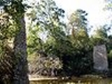
The Nectar Covered Bridge was built by a crew led by Zelmer C. Tidwell and uncle Forrest Tidwell over a wide section of the Locust Fork. It was once a community meeting place and a site for large baptism ceremonies. A concrete bridge has since replaced the former covered bridge, but the old stone piers remain across the river...located south of the current crossover. During its existence, the Nectar Covered Bridge was said to have been haunted by the ghost of a mail carrier who had died there.Further reading
- Prince, A. G. (1981) Alabama's Covered Bridges: Past and Present. revised edition. Ensley: Best Printing Service
- Dale J. Travis Covered Bridges. Nectar CB: Credits. Retrieved Sep. 24, 2007.
- Bridges to the Past: Alabama's Covered Bridges. Nectar CB: Credits. Retrieved Sep. 24, 2007.
- BhamWiki. Nectar CB: Credits. Retrieved Sep. 24, 2007.
- Southern Living: Tunnels in Time. Nectar CB: Credits. Retrieved Sep. 24, 2007.
- The Birmingham News (July 17, 1972) news article. Retrieved Oct. 30, 2007.
- Alabama Department of Archives and History. Nectar CB: Credits. Retrieved Oct. 30, 2007.