

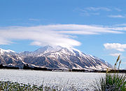
Mount Hutt, New Zealand
Encyclopedia
Canterbury Plains
The Canterbury Plains are an area in New Zealand centred to the south of the city of Christchurch in the Canterbury Region. Their northern extremes are at the foot of the Hundalee Hills in the Hurunui District, and in the south they merge into the plains of North Otago beyond the Waitaki...
in the South Island
South Island
The South Island is the larger of the two major islands of New Zealand, the other being the more populous North Island. It is bordered to the north by Cook Strait, to the west by the Tasman Sea, to the south and east by the Pacific Ocean...
of New Zealand
New Zealand
New Zealand is an island country in the south-western Pacific Ocean comprising two main landmasses and numerous smaller islands. The country is situated some east of Australia across the Tasman Sea, and roughly south of the Pacific island nations of New Caledonia, Fiji, and Tonga...
, above the braided upper reaches of the Rakaia River
Rakaia River
The Rakaia River is in the Canterbury Plains in New Zealand's South Island. The Rakaia River is one of the largest braided rivers in New Zealand...
, and 80 kilometres west of Christchurch
Christchurch
Christchurch is the largest city in the South Island of New Zealand, and the country's second-largest urban area after Auckland. It lies one third of the way down the South Island's east coast, just north of Banks Peninsula which itself, since 2006, lies within the formal limits of...
. Its summit is 2190 metres above sea level.
Skifield
The mountain is home to a commercial alpine ski area with the largest skiable area in the South Island (3.65 square kilometres), and a vertical height of 683 metres.It caters for a wide range of skiers, with a "magic carpet" lift for beginners, good intermediate and advanced runs, and access to large off-piste areas. The most advanced runs on the mountain are through the rock formations at the top of the field known as "The Towers", and the South Face. Lift facilities include a high-speed six seater chair, a quad chair, triple chair and magic carpet. The magic carpet is the world's first fully enclosed by shipping containers.
The snow season is from June to October. Mount Hutt prides itself on and historically has been the first ski-field in the Southern Hemisphere to open at the beginning of each season. However, its steep thirteen kilometre access road is prone to closure in poor weather, giving the skifield the nickname "Mount Shut." On 12 August 2010, winds of up to 200 km/h struck the ski area, resulting in its closure along with the access road, and stranding 1200 people on the mountain overnight, where they were accommodated in the ski-field's base buildings. The road was reopened the following day.
Since there is no accommodation on the mountain, most visitors stay in the nearby town of Methven
Methven, New Zealand
Methven is a small town in the Canterbury region of the South Island of New Zealand. It is located near the western edge of the Canterbury Plains, 35 kilometres north of Ashburton. It was originally the railhead of a short branch railway off the Main South Line...
, a 35 minute drive to the mountain. The larger town of Ashburton
Ashburton, New Zealand
Ashburton is a town and district in the Canterbury Region on the east coast of the South Island of New Zealand. It is the third-largest centre in Canterbury, after Christchurch and Timaru. The area around Ashburton is frequently referred to as Mid Canterbury, which is also the name of the...
is 55 minutes away. The city of Christchurch
Christchurch
Christchurch is the largest city in the South Island of New Zealand, and the country's second-largest urban area after Auckland. It lies one third of the way down the South Island's east coast, just north of Banks Peninsula which itself, since 2006, lies within the formal limits of...
is just over an hour's drive away.
Mt Hutt is managed by Southern Alpine Recreation Ltd along with Coronet Peak
Coronet Peak
Coronet Peak is a commercial skifield in Otago, New Zealand located 18 kilometres to the northeast of the town of Queenstown and seven kilometres west of Arrowtown, on the southern slopes of the 1,649 metre peak which shares its name...
and The Remarkables in Queenstown.