

Bluff, New Zealand
Encyclopedia
South Island
The South Island is the larger of the two major islands of New Zealand, the other being the more populous North Island. It is bordered to the north by Cook Strait, to the west by the Tasman Sea, to the south and east by the Pacific Ocean...
of New Zealand
New Zealand
New Zealand is an island country in the south-western Pacific Ocean comprising two main landmasses and numerous smaller islands. The country is situated some east of Australia across the Tasman Sea, and roughly south of the Pacific island nations of New Caledonia, Fiji, and Tonga...
. It is the southern-most town in New Zealand and, despite Slope Point
Slope Point
Slope Point is the southernmost point of the South Island of New Zealand.Slope Point lies just south of the small settlements of Waikawa and Haldane, near the southwestern edge of the Catlins and Toetoes Bay and 70 km east of Invercargill....
being further to the south, is colloquially used to refer to the southern extremity of the country (particularly in the phrase "from Cape Reinga
Cape Reinga
Cape Reinga is the northwesternmost tip of the Aupouri Peninsula, at the northern end of the North Island of New Zealand. Cape Reinga is located over 100 km north of the nearest small town of Kaitaia. State Highway 1 extends all the way to the Cape, but until 2010 was unsealed gravel road for the...
to The Bluff"). According to the 2006 census, the usually resident population was 1,850, a decrease of 85 since 2001.
The Bluff area, while itself not settled by Māori, was one of the earliest areas of New Zealand where a European presence became established. The first ship known to have entered the harbour was the Perseverance in 1813, in search of flax
Flax
Flax is a member of the genus Linum in the family Linaceae. It is native to the region extending from the eastern Mediterranean to India and was probably first domesticated in the Fertile Crescent...
trading possibilities, with the first European settlers arriving in 1823/1824. This is the foundation for the claim that this makes Bluff the oldest permanent European settlement in the country. However the missionary settlement at Kerikeri
Kerikeri
Kerikeri, the largest town in the Northland Region of New Zealand, is a popular tourist destination about three hours drive north of Auckland, and 80 km north of Whangarei...
was both earlier and larger and the town is now larger than that of Bluff. The town was officially called Campbelltown in 1856, became a borough in 1878, and was renamed Bluff in 1917 http://www.teara.govt.nz/en/1966/bluff/1.
Geography
Bluff is 30 km by road from InvercargillInvercargill
Invercargill is the southernmost and westernmost city in New Zealand, and one of the southernmost cities in the world. It is the commercial centre of the Southland region. It lies in the heart of the wide expanse of the Southland Plains on the Oreti or New River some 18 km north of Bluff,...
, and the southern terminus of the Bluff Branch
Bluff Branch
The Bluff Branch is a railway line in Southland, New Zealand that links Invercargill with the port of Bluff. One of the first railways in New Zealand, it opened in 1867 and is still operating...
, the continuation from Invercargill of the Main South Line
Main South Line
The Main South Line, sometimes referred to as part of the South Island Main Trunk Railway, is a railroad line that runs north and south from Lyttelton in New Zealand through Christchurch and along the east coast of the South Island to Invercargill via Dunedin...
. This was one of New Zealand's earliest railways, opening on 5 February 1867.
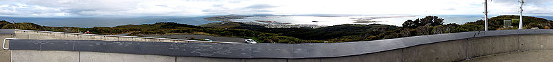
Bluff is at the end of a peninsula
Peninsula
A peninsula is a piece of land that is bordered by water on three sides but connected to mainland. In many Germanic and Celtic languages and also in Baltic, Slavic and Hungarian, peninsulas are called "half-islands"....
that forms the western side of Bluff Harbour and Awarua Bay, with the port located in the relatively narrow entrance channel. It is on State Highway 1
New Zealand State Highway network
The New Zealand State Highway network is the major national highway network in New Zealand. Just under 100 roads in both the North and South Islands are State Highways...
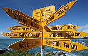
, which terminates one kilometre to the south of the town at Stirling Point. At Stirling Point there is a signpost showing the distance and direction to various major cities and locations around the world, including the Equator and the South Pole.
Bluff is dominated by Bluff Hill / Motupohue (standing at 265m), an extinct volcanic cone
Volcanic cone
Volcanic cones are among the simplest volcanic formations. They are built by ejecta from a volcanic vent, piling up around the vent in the shape of a cone with a central crater. Volcanic cones are of different types, depending upon the nature and size of the fragments ejected during the eruption...
, which provides some shelter from the prevailing westerly winds. There is a world-class walk along the shore through native bush up to this point. The town is named for this bluff
Hill
A hill is a landform that extends above the surrounding terrain. Hills often have a distinct summit, although in areas with scarp/dip topography a hill may refer to a particular section of flat terrain without a massive summit A hill is a landform that extends above the surrounding terrain. Hills...
, which was known to early whaler
Whaling
Whaling is the hunting of whales mainly for meat and oil. Its earliest forms date to at least 3000 BC. Various coastal communities have long histories of sustenance whaling and harvesting beached whales...
s as Old Man's Bluff or Old Man Bluff. East across the entry channel from Bluff is Tiwai Point
Tiwai Point
thumb|[[Awarua Plain]] , Tiwai Point and [[Bluff, New Zealand|Bluff]] viewed from the [[International Space Station]] in 2008.Tiwai Point lies at the entrance to Bluff Harbour on the southern coast of the South Island of New Zealand...
, home to New Zealand's only aluminium smelter
Aluminium smelting
Aluminium smelting is the process of extracting aluminium from its oxide alumina, generally by the Hall-Héroult process. Alumina is extracted from the ore Bauxite by means of the Bayer process at an alumina refinery....
and its wharf
Wharf
A wharf or quay is a structure on the shore of a harbor where ships may dock to load and unload cargo or passengers.Such a structure includes one or more berths , and may also include piers, warehouses, or other facilities necessary for handling the ships.A wharf commonly comprises a fixed...
.
Facilities
South Port is the port operating company of the Port of Bluff, and is owned to 66.5% by the Southland Regional CouncilSouthland Regional Council
The Southland Regional Council is the southernmost regional council in New Zealand. In 2006, it had an operating revenue of NZ$19.6 million, NZ$7.1 million of this from rates revenue....
. A small port in comparison with New Zealand giants like Ports of Auckland
Ports of Auckland
Ports of Auckland Limited , the successor to the Auckland Harbour Board, is the company administering Auckland's commercial freight and cruise ship harbour facilities...
or Port of Tauranga
Port of Tauranga
Port of Tauranga is the port of Tauranga, New Zealand, the largest port in the country in terms of total cargo volume, and the second largest in terms of container throughput. with Port of Tauranga Ltd being the company operating it...
, it moves around 2.2 million tonnes of cargo each year, mostly New Zealand coastal reshipment. It is hoped that the Tiwai Point aluminium smelter and fossil fuel exploration activity in the Great South Basin will help to ensure the future relevance of the port. A recent (2008) weekly container ship service also lifted the volumes.
Bluff harbour is also the terminus for the twice-daily catamaran
Catamaran
A catamaran is a type of multihulled boat or ship consisting of two hulls, or vakas, joined by some structure, the most basic being a frame, formed of akas...
ferry
Ferry
A ferry is a form of transportation, usually a boat, but sometimes a ship, used to carry primarily passengers, and sometimes vehicles and cargo as well, across a body of water. Most ferries operate on regular, frequent, return services...
to Stewart Island/Rakiura
Stewart Island/Rakiura
Stewart Island/Rakiura is the third-largest island of New Zealand. It lies south of the South Island, across Foveaux Strait. Its permanent population is slightly over 400 people, most of whom live in the settlement of Oban.- History and naming :...
, 60 km south across Foveaux Strait
Foveaux Strait
Foveaux Strait separates Stewart Island/Rakiura, New Zealand's third largest island, from the South Island. Three large bays, Te Waewae Bay, Oreti Beach and Toetoes Bay, sweep along the strait's northern coast, which also hosts Bluff township and harbour. Across the strait lie the Solander...
. It is the main gateway for NZ ships heading down to the Antarctic. The harbour is also home to the Foveaux Strait oyster
Oyster
The word oyster is used as a common name for a number of distinct groups of bivalve molluscs which live in marine or brackish habitats. The valves are highly calcified....
fleet
Fishing fleet
A fishing fleet is an aggregate of commercial fishing vessels. The term may be used of all vessels operating out of a particular port, all vessels engaged in a particular type of fishing , or all fishing vessels of a country or region.Although fishing vessels are not formally organized as if they...
. Bluff oysters are renowned for their succulence and flavour, and are considered a delicacy nationwide, with Bluff holding an annual oyster festival. The oyster quota was severely reduced during the 1990s due to the effects of the toxic protozoan parasite Bonamia exitiosa upon the oyster beds.
Among the attractions of the town was the Paua house, created by the (now deceased) Fred and Myrtle Flutey. This house was an ordinary bungalow
Bungalow
A bungalow is a type of house, with varying meanings across the world. Common features to many of these definitions include being detached, low-rise , and the use of verandahs...
transformed by having the outside walls totally covered in paua
Paua
Pāua is the Māori name given to three species of large edible sea snails, marine gastropod molluscs which belong to the family Haliotidae , known in the United States and Australia as abalone, and in the United Kingdom as ormer shells.-Species:There are three species of New Zealand pāua:New...
shells. The interior was also extensively decorated with paua and there is an extensive collection of (often kitsch
Kitsch
Kitsch is a form of art that is considered an inferior, tasteless copy of an extant style of art or a worthless imitation of art of recognized value. The concept is associated with the deliberate use of elements that may be thought of as cultural icons while making cheap mass-produced objects that...
) paua-decorated ornaments, utensils and trinkets. The house became a museum
Museum
A museum is an institution that cares for a collection of artifacts and other objects of scientific, artistic, cultural, or historical importance and makes them available for public viewing through exhibits that may be permanent or temporary. Most large museums are located in major cities...
after the death of the owners, but was sold and in March 2007 the exhibits removed to Christchurch.
The Bluff Maritime Museum
Bluff Maritime Museum
The Bluff Maritime Museum is located in New Zealand's southern-most port of Bluff. The museum is situated on Foreshore Road and contains an extensive collection of Bluff's maritime heritage.- History of the museum :...
contains an extensive collection of models, boats, artefacts, displays, a working triple expansion engine and a full sized oystering boat, The Monica.
External links
- Bluff (from Bluff Promotions)
- Bluff in the 1966 Encyclopaedia of New Zealand]