
Haast, New Zealand
Encyclopedia

Westland District
Westland District is a territorial authority on the west coast of New Zealand's South Island. Its population is - Government :The Westland District is governed by an elected Council, headed by an elected Mayor. The Mayor is elected at large. The current Mayor is Maureen Pugh. Councillors are...
territorial authority on the west coast
West Coast, New Zealand
The West Coast is one of the administrative regions of New Zealand, located on the west coast of the South Island, and is one of the more remote and most sparsely populated areas of the country. It is made up of three districts: Buller, Grey and Westland...
of New Zealand
New Zealand
New Zealand is an island country in the south-western Pacific Ocean comprising two main landmasses and numerous smaller islands. The country is situated some east of Australia across the Tasman Sea, and roughly south of the Pacific island nations of New Caledonia, Fiji, and Tonga...
's South Island
South Island
The South Island is the larger of the two major islands of New Zealand, the other being the more populous North Island. It is bordered to the north by Cook Strait, to the west by the Tasman Sea, to the south and east by the Pacific Ocean...
. The Haast region covers over 2500 km² (965.3 sq mi).
The region is named after Julius von Haast
Julius von Haast
Sir Johann Franz "Julius" von Haast was a German geologist. He founded Canterbury Museum at Christchurch.-Biography:...
, a Prussian
Kingdom of Prussia
The Kingdom of Prussia was a German kingdom from 1701 to 1918. Until the defeat of Germany in World War I, it comprised almost two-thirds of the area of the German Empire...
born geologist instrumental in the early geological surveys of New Zealand.
The 2006 census
New Zealand Census of Population and Dwellings
The New Zealand government department Statistics New Zealand conducts a census of population and dwellings every five years. The census scheduled for 2011 was cancelled due to circumstances surrounding the February 2011 Christchurch earthquake, however, and legislation introduced to hold the next...
recorded a population of 297 for the Haast statistical area, a decrease of 12 from the 2001 census. The majority of this population is located in three communities - the Haast township, Haast Junction, and Haast Beach.
The main economic activities in the Haast region are farming, fishing and tourism.
Lake Moeraki
Lake Moeraki
Lake Moeraki is a small lake on the Moeraki River on the West Coast of the South Island of New Zealand. State Highway 6 runs along its western edge.The lake is surrounded by native vegetation and lies within the Te Wahipounamu World Heritage site....
is 30 km (18.6 mi) to the northeast, and the Haast Pass
Haast Pass
Haast Pass is a mountain pass in the Southern Alps of the South Island of New Zealand. It is named for Julius von Haast, a 19th century explorer who was also geologist for the Provincial government of Canterbury...
is 63 km (39.1 mi) to the southeast by road. State Highway 6
New Zealand State Highway 6
State Highway 6 is a major New Zealand State Highway. It extends from the northeastern corner of the South Island across the top of the island, then down the length of the island, initially along the West Coast and then across the Southern Alps through inland Otago and finally across the Southland...
passes through Haast Junction and just to the east of Haast township.
The rarest subspecies of kiwi
Kiwi
Kiwi are flightless birds endemic to New Zealand, in the genus Apteryx and family Apterygidae.At around the size of a domestic chicken, kiwi are by far the smallest living ratites and lay the largest egg in relation to their body size of any species of bird in the world...
, the Haast Tokoeka
Tokoeka
The Southern Brown Kiwi, Tokoeka, or Common kiwi, Apteryx australis, is a species of kiwi from New Zealand's South Island. Until 2000 it was considered conspecific with the North Island Brown Kiwi, and still is by some authorities.-Taxonomy:...
, are only found in the mountains of the Haast region.
History
European settlement of the area dates back to the 1870s. The remoteness of the area initially limited access to sea-going vessels, with some rough tracks from the north and east.The present Haast township was originally a New Zealand Ministry of Works
New Zealand Ministry of Works
The New Zealand Ministry of Works, formerly the Department of Public Works and sometimes referred to as the Public Works Department or PWD, was founded in 1876 and disestablished and privatised in 1988...
road construction camp, which expanded into a permanent township when the opening of the Haast Pass in 1962 made the region more accessible. The road through the pass to Wanaka
Wanaka
Wanaka is a town in the Otago region of the South Island of New Zealand. It is situated at the southern end of Lake Wanaka, adjacent to the outflow of the lake to the Clutha River. It is the gateway to Mount Aspiring National Park. Wanaka is primarily a resort town but has both summer and winter...
was upgraded in 1966.
In 1990 the Haast area was included as part of a UNESCO
UNESCO
The United Nations Educational, Scientific and Cultural Organization is a specialized agency of the United Nations...
World Heritage Site
World Heritage Site
A UNESCO World Heritage Site is a place that is listed by the UNESCO as of special cultural or physical significance...
, giving international recognition as a location of significant natural value to Te Wahipounamu
Te Wahipounamu
Te Wāhipounamu is a World Heritage site in the south west corner of the South Island of New Zealand.Inscribed on the World Heritage List in 1990 and covering 26,000 km², the site incorporates several National Parks:...
- The South West New Zealand World Heritage Area.
Communities
Haast Junction is located on the southwest bank of the Haast RiverHaast River
The Haast River has its terminus on the West Coast of the South Island of New Zealand.The Haast River drains the western watershed of the Haast Pass. It is 100 kilometres in length, and enters the Tasman Sea near Haast township. The river's main tributary is the Landsborough River.The grassy flats...
, immediately south of the Haast Bridge, at the junction of State Highway 6 and the Haast-Jackson Bay Road.
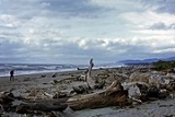
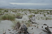
The smaller Haast Beach is located on the coast of the Tasman Sea
Tasman Sea
The Tasman Sea is the large body of water between Australia and New Zealand, approximately across. It extends 2,800 km from north to south. It is a south-western segment of the South Pacific Ocean. The sea was named after the Dutch explorer Abel Janszoon Tasman, the first recorded European...
, approximately 12 km (7.5 mi) west souththwest of Haast Junction, on the Haast-Jackson Bay Road.
The larger Haast township is located on the Haast River, approximately 3 km (1.9 mi) south of Haast Junction, on State Highway 6. The New Zealand Department of Conservation operates a visitor centre in Haast township, offering a wide range of information about the surrounding area.
Education
The Haast School is a coeducational full primary (years 1-8) school with a Ministry of EducationMinistry of Education (New Zealand)
The Ministry of Education , is the primary state sector organisation of New Zealand responsible for New Zealand's education system...
decile rating
Socio-Economic Decile
Decile, Socio-Economic Decile or Socio-Economic Decile Band is a widely used measure in education in New Zealand used to target funding and support to more needy schools....
of 3 and a student roll of 21.
External links
- Haast at the Department of Conservation
- Haast Promotions Group