
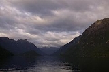
Lake Manapouri
Encyclopedia
Lake Manapouri is a lake
in the South Island
of New Zealand
. Its name is Maori
for "sorrowful heart", though this name is misapplied due to an early cartographical error (the real Lake Manapouri was North Mavora Lake
, which lies some distance to the east). Local Maori called Lake Manapouri Moturau, which means "many islands".
Lake Manapouri has four major arms, North, South, West and Hope, and the smaller indentations of Calm Bay and Shallow Bay. The lake contains some 34 islands, 22 of which are wooded. The largest of these is Pomona Island
, which lies close to the centre of the lake. Other large islands include Holmwood island, Rona Island, and Mahara Island.
The Waiau River
is both a natural inflow and outlet for the lake, flowing into the northeast of the lake from Lake Te Anau
, 20 kilometres to the north, and flowing out from Manapouri's southeastern end. The lake's catchment is also largely served by the slopes of the Kepler Mountains, Turret Range and Hunter Mountains
which surround all but the eastern shore of the lake. The small settlement of Manapouri
lies on the eastern shore between the inflow and outflow of the Waiau, and is a popular destination for tourists.
The lake provides hydro-electric power via Manapouri Power Station
, in West Arm, which discharges water through two 10-km tailrace tunnels to Doubtful Sound
and the sea. In 1959 it was proposed to raise the lake by up to 30 metres for the power station. This resulted in a strong nationwide protest lasting over a decade, which prevented the raising of the lake from taking place. That campaign, the Save Manapouri Campaign
, is regarded as a major milestone in the history of New Zealand's environmental protection. The lake levels are carefully controlled to be close to natural fluctuations.
The lake is within Fiordland National Park
and the Te Wahipounamu
World Heritage site
.
Lake
A lake is a body of relatively still fresh or salt water of considerable size, localized in a basin, that is surrounded by land. Lakes are inland and not part of the ocean and therefore are distinct from lagoons, and are larger and deeper than ponds. Lakes can be contrasted with rivers or streams,...
in the South Island
South Island
The South Island is the larger of the two major islands of New Zealand, the other being the more populous North Island. It is bordered to the north by Cook Strait, to the west by the Tasman Sea, to the south and east by the Pacific Ocean...
of New Zealand
New Zealand
New Zealand is an island country in the south-western Pacific Ocean comprising two main landmasses and numerous smaller islands. The country is situated some east of Australia across the Tasman Sea, and roughly south of the Pacific island nations of New Caledonia, Fiji, and Tonga...
. Its name is Maori
Maori language
Māori or te reo Māori , commonly te reo , is the language of the indigenous population of New Zealand, the Māori. It has the status of an official language in New Zealand...
for "sorrowful heart", though this name is misapplied due to an early cartographical error (the real Lake Manapouri was North Mavora Lake
Mavora Lakes
The Mavora Lakes are located in the South Island of New Zealand.They consist of two lakes named North Mavora and South Mavora. The area has rudimentary camping sites and is maintained by the Department of Conservation. This park was also used as a film location for the Lord of the Rings movie...
, which lies some distance to the east). Local Maori called Lake Manapouri Moturau, which means "many islands".
Lake Manapouri has four major arms, North, South, West and Hope, and the smaller indentations of Calm Bay and Shallow Bay. The lake contains some 34 islands, 22 of which are wooded. The largest of these is Pomona Island
Pomona Island
Pomona Island is the largest island within Lake Manapouri, in Fiordland National Park, in New Zealand's South Island. With an area of , it is one of the largest islands to be found within any New Zealand lake....
, which lies close to the centre of the lake. Other large islands include Holmwood island, Rona Island, and Mahara Island.
The Waiau River
Waiau River, Southland
Waiau River is the largest river in the Southland Region of New Zealand. It is the outflow of Lake Te Anau, flowing from it into Lake Manapouri 10 kilometres to the south, and from there flows south for 70 kilometres before reaching the Foveaux Strait eight kilometres south of Tuatapere...
is both a natural inflow and outlet for the lake, flowing into the northeast of the lake from Lake Te Anau
Lake Te Anau
Lake Te Anau is in the southwestern corner of the South Island of New Zealand. Its name was originally Te Ana-au, Maori for 'The cave of swirling water'. The lake covers an area of 344 km², making it the second-largest lake by surface area in New Zealand and the largest in the South Island...
, 20 kilometres to the north, and flowing out from Manapouri's southeastern end. The lake's catchment is also largely served by the slopes of the Kepler Mountains, Turret Range and Hunter Mountains
Hunter Mountains
The Hunter Mountains of Lake Manapouri New Zealand named by Surveyor James McKerrow after the Famous anatomist John Hunter. The Hunter Mountain Range covers an area between The South Arm and Hope Arm of Lake Manapouri South to the Green Lake...
which surround all but the eastern shore of the lake. The small settlement of Manapouri
Manapouri
Manapouri is a small town in Southland / Fiordland, in the southwest corner of the South Island, in New Zealand. Located at the edge of the Fiordland National Park, on the eastern shore of Lake Manapouri, close to its outflow into the Waiau River, tourist boat services are based in the...
lies on the eastern shore between the inflow and outflow of the Waiau, and is a popular destination for tourists.
The lake provides hydro-electric power via Manapouri Power Station
Manapouri Power Station
Manapouri Power Station is an underground hydroelectric power station on the western arm of Lake Manapouri in Fiordland National Park, in the South Island of New Zealand...
, in West Arm, which discharges water through two 10-km tailrace tunnels to Doubtful Sound
Doubtful Sound
Doubtful Sound is a very large and naturally imposing fjord in Fiordland, in the far south west of New Zealand. It is located in the same region as the smaller but more famous and accessible Milford Sound...
and the sea. In 1959 it was proposed to raise the lake by up to 30 metres for the power station. This resulted in a strong nationwide protest lasting over a decade, which prevented the raising of the lake from taking place. That campaign, the Save Manapouri Campaign
Save Manapouri Campaign
The Save Manapouri Campaign was an environmental campaign waged between 1959 and 1972 in New Zealand to prevent the raising of the levels of lakes Manapouri and Te Anau as part of the construction of the Manapouri Power Project....
, is regarded as a major milestone in the history of New Zealand's environmental protection. The lake levels are carefully controlled to be close to natural fluctuations.
The lake is within Fiordland National Park
Fiordland National Park
Fiordland National Park occupies the southwest corner of the South Island of New Zealand. It is the largest of the 14 national parks in New Zealand, with an area of 12,500 km², and a major part of the Te Wahipounamu World Heritage site...
and the Te Wahipounamu
Te Wahipounamu
Te Wāhipounamu is a World Heritage site in the south west corner of the South Island of New Zealand.Inscribed on the World Heritage List in 1990 and covering 26,000 km², the site incorporates several National Parks:...
World Heritage site
World Heritage Site
A UNESCO World Heritage Site is a place that is listed by the UNESCO as of special cultural or physical significance...
.