
Palmerston, New Zealand
Encyclopedia
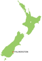
The town of Palmerston, in New Zealand
's South Island
lies 50 kilometres to the north of the city of Dunedin
. It is the largest town in the Waihemo Ward of the Waitaki District with a population of 890 residents. Palmerston grew at a major road junction: State Highway 1
links Dunedin
and Waikouaiti
to the south with Oamaru
and Christchurch
to the north, whereas State Highway 85
(known colloquially as "The Pigroot") heads inland to become the principal highway of the Maniototo
. The Main South Line
railway passes through the town and a tourist train, the Seasider
travels from Dunedin to Palmerston and back once or twice a week. From 1880 until 1989, the town acted as the junction between the main line and a branch line
that ran inland, the Dunback and Makareao Branches
.
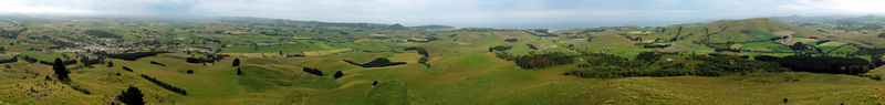
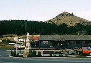
Palmerston stands near the banks of the Shag River
, five kilometres inland from the Pacific
coast. Between it and the sea stands the lone hill of Puketapu (Maori
for sacred head, known by Southerners as Holy Hill), crowned with a monument to the 19th century Otago politician
Sir John McKenzie
. An annual race takes place up to the memorial and back which is called the Kelly's canter dedicated to Albert Kelly who ran up Puketapu as a constable in the Palmerston police force every day during World War II
.
Many people confuse the town of Palmerston with the much more populous North Island
city of Palmerston North, whose residents often call their home simply "Palmerston". Otago
's town has the earlier claim to the name, however - its surveying dates from 1862, whereas the northern city did not receive its name until 1871. Both towns take their names from Lord Palmerston, the 19th-century British
Prime Minister
.
The nearby Shag River
, whose name causes visitors much amusement, especially those from Britain, is named for the cormorant, a sea bird which also ventures a little inland, colloquially known as a 'shag'. The river's Maori name, 'Waihemo', has been translated as 'Dwindle River'. It is thought to arise from the river's tendency to reduce in summer to a small stream. Palmerston used to be the capital of the Waihemo County, the surrounding district, before it was amalgamated with the Waitaki District in 1989.
 The area is rich in history and legend. Modern archaeology favours a date for the first settlement of New Zealand by Polynesian
people about 1300 AD when population was concentrated on the east coast of the South Island. There is a substantial early settlement site of the Archaic or moa hunter phase of Maori culture near Palmerston on the sea coast at the mouth of the Shag River. It has been known to Europeans since the 1840s and was investigated from an early time by archaeologists. In 1987 and 1989 it was very thoroughly re-excavated by a team including Professor Atholl Anderson. It was determined it had been in permanent, year round occupation 'for a period of perhaps 20–50 years in the 14th century AD'. (Anderson and others,1996,p. 67.)
The area is also the traditional site of the wreck of the Arai Te Uru
canoe. There are several versions of the tradition but they tell of the arrival of Rakaihautu from the ancestral homeland Hawaiki who met the Kahui Tipua people who were already here. He showed them kumara, or sweet potatoes, and they built canoes including Arai Te Uru to go to Hawaiki and bring back this new and valuable food. However on its return the vessel became waterlogged off the Waitaki River Mouth, spilled food baskets on Moeraki and Kartigi beaches and was wrecked at Matakaea, Shag Point, where it turned into what is now called Danger Reef. Its steersman, Hipo, sits erect at the stern. After this the crew explored the southern South Island giving many place names. Kahui Tipua are 'ghost or giant people' with mythic or magical attributes, although they are also the real ancestors of people living now. (Anderson, 1983, p. 7.) If the explorers didn't get back before dawn they turned into hills and other natural features. One of them was a woman Puketapu who got as far south as Owaka
in South Otago. When she got back to the Waihemo Valley dawn broke and she was turned into the hill Puketapu overlooking Palmerston.
 The story is seen as an allegorical explanation of the fact that kumara won't grow south of Banks Peninsula. Arai Te Uru is an ancestral canoe of the Kati Mamoe people who came to the south before Kai Tahu (Ngai Tahu in modern standard Maori) but were preceded by earlier peoples. The Arai Te Uru tradition reflects this with its reference to the preceding Kahui Tipua. It is tempting to identify the occupants of the river mouth archaeological site with the people of Arai Te Uru but that can only be speculation.
In 1814 an open boat from the Matilda, Captain Fowler, under the first mate Robert Brown, with two other Europeans and five lascars, or Indian seamen, came up the east coast past Palmerston and camped for the night ashore north of Moeraki. They were seen and attacked by Maori because of a feud started four years earlier by the theft of a shirt. According to the Creed manuscript, discovered in 2003, two men 'escaped through the darkness of the night & fled as far as Goodwood Bobby's Head' a little south of Palmerston on the coast. They were two days and nights on the way and the Maori people there fed them. However '30 Natives went to the place & massacred them - eat them.' One of the Europeans put up a grim struggle and the mere or club which dispatched him was long remembered. There was a dispute about killing these men after they had been entertained but those bent on vengeance prevailed.
In May 1826 Thomas Shepherd, (1779–1835), passing this coast in the Rosanna, made a sketch of it which still survives in the Mitchell Library, Sydney.
There were European visitors in the 1840s, such as Edward Shortland. Charles Suisted took up land in the area in the 1850s and Palmerston came into existence as a camp site in 1862 as the beginning of a route by the Shag Valley to the Central Otago
gold diggings. It was surveyed and named in 1864. There is a handsome Presbyterian Church made of a local sandstone, designed by David Ross in 1876. A marble statue of Zealandia by Carlo Bergamini
in the centre of the town is a Boer War
memorial.
A few kilometres inland, at the Shag Valley Station, Frank Bell made the first New Zealand to England radio contact on 18 October 1924, an event which attracted international media attention as the first round-the-world radio broadcast.
New Zealand
New Zealand is an island country in the south-western Pacific Ocean comprising two main landmasses and numerous smaller islands. The country is situated some east of Australia across the Tasman Sea, and roughly south of the Pacific island nations of New Caledonia, Fiji, and Tonga...
's South Island
South Island
The South Island is the larger of the two major islands of New Zealand, the other being the more populous North Island. It is bordered to the north by Cook Strait, to the west by the Tasman Sea, to the south and east by the Pacific Ocean...
lies 50 kilometres to the north of the city of Dunedin
Dunedin
Dunedin is the second-largest city in the South Island of New Zealand, and the principal city of the Otago Region. It is considered to be one of the four main urban centres of New Zealand for historic, cultural, and geographic reasons. Dunedin was the largest city by territorial land area until...
. It is the largest town in the Waihemo Ward of the Waitaki District with a population of 890 residents. Palmerston grew at a major road junction: State Highway 1
New Zealand State Highway network
The New Zealand State Highway network is the major national highway network in New Zealand. Just under 100 roads in both the North and South Islands are State Highways...
links Dunedin
Dunedin
Dunedin is the second-largest city in the South Island of New Zealand, and the principal city of the Otago Region. It is considered to be one of the four main urban centres of New Zealand for historic, cultural, and geographic reasons. Dunedin was the largest city by territorial land area until...
and Waikouaiti
Waikouaiti
Waikouaiti is a small town in East Otago, New Zealand, within the city limits of Dunedin. The town is close to the coast and the mouth of the Waikouaiti River....
to the south with Oamaru
Oamaru
Oamaru , the largest town in North Otago, in the South Island of New Zealand, is the main town in the Waitaki District. It is 80 kilometres south of Timaru and 120 kilometres north of Dunedin, on the Pacific coast, and State Highway 1 and the railway Main South Line connects it to both...
and Christchurch
Christchurch
Christchurch is the largest city in the South Island of New Zealand, and the country's second-largest urban area after Auckland. It lies one third of the way down the South Island's east coast, just north of Banks Peninsula which itself, since 2006, lies within the formal limits of...
to the north, whereas State Highway 85
New Zealand State Highway 85
State Highway 85 is a South Island State Highway in New Zealand, servicing the Maniototo Plains and the North and Central Otago regions of the South Island between the major settlements of Alexandra and Palmerston. It is wholly two lane and passes through some of the most extreme climatic regions...
(known colloquially as "The Pigroot") heads inland to become the principal highway of the Maniototo
Maniototo
The Maniototo Plain, usually simply known as The Maniototo, is an elevated inland region in Otago, New Zealand. The region roughly surrounds the upper reaches of the Taieri River and the Manuherikia River. It is bounded by the Kakanui Range to the north and the Rock and Pillar Range to the southeast...
. The Main South Line
Main South Line
The Main South Line, sometimes referred to as part of the South Island Main Trunk Railway, is a railroad line that runs north and south from Lyttelton in New Zealand through Christchurch and along the east coast of the South Island to Invercargill via Dunedin...
railway passes through the town and a tourist train, the Seasider
Seasider (train)
The Seasider is a tourist train in the South Island of New Zealand, operated by the Taieri Gorge Railway along the Main South Line between the historic Dunedin Railway Station and Palmerston once or twice a week in the summer months and occasionally during winter. Since the demise of the...
travels from Dunedin to Palmerston and back once or twice a week. From 1880 until 1989, the town acted as the junction between the main line and a branch line
Branch line
A branch line is a secondary railway line which branches off a more important through route, usually a main line. A very short branch line may be called a spur line...
that ran inland, the Dunback and Makareao Branches
Dunback and Makareao Branches
The Dunback and Makareao Branches were two connected branch line railways, part of New Zealand's national rail network. Located in the Otago region of the South Island, both lines were 15km in length and shared the first 11km...
.
Palmerston stands near the banks of the Shag River
Shag River
Shag River is located in Otago in the South Island of New Zealand. It rises in the Kakanui Range, flowing southeast for 50 kilometres before reaching the Pacific Ocean near the town of Palmerston...
, five kilometres inland from the Pacific
Pacific Ocean
The Pacific Ocean is the largest of the Earth's oceanic divisions. It extends from the Arctic in the north to the Southern Ocean in the south, bounded by Asia and Australia in the west, and the Americas in the east.At 165.2 million square kilometres in area, this largest division of the World...
coast. Between it and the sea stands the lone hill of Puketapu (Maori
Maori language
Māori or te reo Māori , commonly te reo , is the language of the indigenous population of New Zealand, the Māori. It has the status of an official language in New Zealand...
for sacred head, known by Southerners as Holy Hill), crowned with a monument to the 19th century Otago politician
Politician
A politician, political leader, or political figure is an individual who is involved in influencing public policy and decision making...
Sir John McKenzie
John McKenzie (New Zealand)
Sir John McKenzie KCMG was a New Zealand politician. He served as Minister of Lands and Agriculture in the Liberal Government of John Ballance.-Early life:...
. An annual race takes place up to the memorial and back which is called the Kelly's canter dedicated to Albert Kelly who ran up Puketapu as a constable in the Palmerston police force every day during World War II
World War II
World War II, or the Second World War , was a global conflict lasting from 1939 to 1945, involving most of the world's nations—including all of the great powers—eventually forming two opposing military alliances: the Allies and the Axis...
.
Many people confuse the town of Palmerston with the much more populous North Island
North Island
The North Island is one of the two main islands of New Zealand, separated from the much less populous South Island by Cook Strait. The island is in area, making it the world's 14th-largest island...
city of Palmerston North, whose residents often call their home simply "Palmerston". Otago
Otago
Otago is a region of New Zealand in the south of the South Island. The region covers an area of approximately making it the country's second largest region. The population of Otago is...
's town has the earlier claim to the name, however - its surveying dates from 1862, whereas the northern city did not receive its name until 1871. Both towns take their names from Lord Palmerston, the 19th-century British
United Kingdom
The United Kingdom of Great Britain and Northern IrelandIn the United Kingdom and Dependencies, other languages have been officially recognised as legitimate autochthonous languages under the European Charter for Regional or Minority Languages...
Prime Minister
Prime minister
A prime minister is the most senior minister of cabinet in the executive branch of government in a parliamentary system. In many systems, the prime minister selects and may dismiss other members of the cabinet, and allocates posts to members within the government. In most systems, the prime...
.
The nearby Shag River
Shag River
Shag River is located in Otago in the South Island of New Zealand. It rises in the Kakanui Range, flowing southeast for 50 kilometres before reaching the Pacific Ocean near the town of Palmerston...
, whose name causes visitors much amusement, especially those from Britain, is named for the cormorant, a sea bird which also ventures a little inland, colloquially known as a 'shag'. The river's Maori name, 'Waihemo', has been translated as 'Dwindle River'. It is thought to arise from the river's tendency to reduce in summer to a small stream. Palmerston used to be the capital of the Waihemo County, the surrounding district, before it was amalgamated with the Waitaki District in 1989.
History and legend
Polynesians
The Polynesian peoples is a grouping of various ethnic groups that speak Polynesian languages, a branch of the Oceanic languages within the Austronesian languages, and inhabit Polynesia. They number approximately 1,500,000 people...
people about 1300 AD when population was concentrated on the east coast of the South Island. There is a substantial early settlement site of the Archaic or moa hunter phase of Maori culture near Palmerston on the sea coast at the mouth of the Shag River. It has been known to Europeans since the 1840s and was investigated from an early time by archaeologists. In 1987 and 1989 it was very thoroughly re-excavated by a team including Professor Atholl Anderson. It was determined it had been in permanent, year round occupation 'for a period of perhaps 20–50 years in the 14th century AD'. (Anderson and others,1996,p. 67.)
The area is also the traditional site of the wreck of the Arai Te Uru
Araiteuru
In Māori mythology, Āraiteuru is the canoe in which brought the ancestors the Ngāi Tahu people of the South Island. The canoe was conveyed to New Zealand by the north-east wind, carrying the chiefs Kirikiri-ka-tata, Aroarokaehe, Mangaatua, Aoraki, Kakeroa, Te Horokoatu, Ritua, Ngamautaurua,...
canoe. There are several versions of the tradition but they tell of the arrival of Rakaihautu from the ancestral homeland Hawaiki who met the Kahui Tipua people who were already here. He showed them kumara, or sweet potatoes, and they built canoes including Arai Te Uru to go to Hawaiki and bring back this new and valuable food. However on its return the vessel became waterlogged off the Waitaki River Mouth, spilled food baskets on Moeraki and Kartigi beaches and was wrecked at Matakaea, Shag Point, where it turned into what is now called Danger Reef. Its steersman, Hipo, sits erect at the stern. After this the crew explored the southern South Island giving many place names. Kahui Tipua are 'ghost or giant people' with mythic or magical attributes, although they are also the real ancestors of people living now. (Anderson, 1983, p. 7.) If the explorers didn't get back before dawn they turned into hills and other natural features. One of them was a woman Puketapu who got as far south as Owaka
Owaka
Owaka is a small town in Otago, in the southern South Island of New Zealand. It is the largest community in the rugged, forested Catlins area, close to the border with Southland, some south of Balclutha on the Southern Scenic Route. The town's population was 334 in the 2006 census, a decrease of...
in South Otago. When she got back to the Waihemo Valley dawn broke and she was turned into the hill Puketapu overlooking Palmerston.
In 1814 an open boat from the Matilda, Captain Fowler, under the first mate Robert Brown, with two other Europeans and five lascars, or Indian seamen, came up the east coast past Palmerston and camped for the night ashore north of Moeraki. They were seen and attacked by Maori because of a feud started four years earlier by the theft of a shirt. According to the Creed manuscript, discovered in 2003, two men 'escaped through the darkness of the night & fled as far as Goodwood Bobby's Head' a little south of Palmerston on the coast. They were two days and nights on the way and the Maori people there fed them. However '30 Natives went to the place & massacred them - eat them.' One of the Europeans put up a grim struggle and the mere or club which dispatched him was long remembered. There was a dispute about killing these men after they had been entertained but those bent on vengeance prevailed.
In May 1826 Thomas Shepherd, (1779–1835), passing this coast in the Rosanna, made a sketch of it which still survives in the Mitchell Library, Sydney.
There were European visitors in the 1840s, such as Edward Shortland. Charles Suisted took up land in the area in the 1850s and Palmerston came into existence as a camp site in 1862 as the beginning of a route by the Shag Valley to the Central Otago
Central Otago
Central Otago is the inland part of the New Zealand region of Otago in the South Island. The area commonly known as Central Otago includes both the Central Otago District and the Queenstown-Lakes District to the west....
gold diggings. It was surveyed and named in 1864. There is a handsome Presbyterian Church made of a local sandstone, designed by David Ross in 1876. A marble statue of Zealandia by Carlo Bergamini
Carlo Bergamini (sculptor)
Carlo Giuseppe Bergamin was a sculptor and monumental mason born in Carrara, in Italy, who later migrated to New Zealand. He is known there as the designer of a number of well-regarded war memorials, in New Zealand, relating to the Boer War....
in the centre of the town is a Boer War
Boer War
The Boer Wars were two wars fought between the British Empire and the two independent Boer republics, the Oranje Vrijstaat and the Republiek van Transvaal ....
memorial.
A few kilometres inland, at the Shag Valley Station, Frank Bell made the first New Zealand to England radio contact on 18 October 1924, an event which attracted international media attention as the first round-the-world radio broadcast.