
West Coast, New Zealand
Encyclopedia
| West Coast Regional Council |
|
| Country: | New Zealand New Zealand New Zealand is an island country in the south-western Pacific Ocean comprising two main landmasses and numerous smaller islands. The country is situated some east of Australia across the Tasman Sea, and roughly south of the Pacific island nations of New Caledonia, Fiji, and Tonga... |
 |
|
| Regional Council | |
|---|---|
| Name: | West Coast Regional Council |
| Chair: | Ross Scarlett |
| Population: | |
| Land Area: | 23,276 km² |
| Website: | www.wcrc.govt.nz |
| Towns | |
| Names: | Greymouth Greymouth Greymouth is the largest town in the West Coast region in the South Island of New Zealand, and the seat of the Grey District Council. The population of the whole Grey District is , which accounts for % of the West Coast's inhabitants... , Hokitika, Westport Westport, New Zealand -Economy:Economic activity is based around fishing, coal mining and dairy farming. Historically, gold mining was a major industry, and coal mining was much more extensive than today . However, the region still is home to New Zealand's largest opencast mining operation in Stockton... , Reefton, Karamea Karamea Karamea is a town on the West Coast of the South Island of New Zealand.It is the northernmost settlement of any real size on the West Coast, and is located 96 kilometres north-east by road from Westport. There is no other connecting road to the town - the road north ends at the Kohaihai River some... , Kumara Kumara, New Zealand Kumara is a town on the West Coast of the South Island of New Zealand. It is located 30 kilometres south of Greymouth, close to the western end of State Highway 73, which leads across Arthur's Pass to Christchurch... , Fox Glacier Fox Glacier The Fox Glacier is a long glacier located in Westland Tai Poutini National Park on the West Coast of New Zealand's South Island... , Haast Haast, New Zealand Haast is an area in the Westland District territorial authority on the west coast of New Zealand's South Island. The Haast region covers over .... , Okuru Okuru Okuru is the name of a locality on the West Coast of New Zealand. The settlement lies 12 kilometres south west of Haast on the northern bank of the Okuru River.... , Jackson Bay Jackson Bay Jackson Bay is a gently curving bay 24 kilometers wide, located on the West Coast of New Zealand's South Island. It faces the Tasman Sea to the north, and is backed by the Southern Alps... |
| Constituent Territorial Authorities | |
| Names: | Buller Buller District 200px|rightBuller District, administered by the Buller District Council is an administrative region in the West Coast Region of New Zealand. It covers Westport, Karamea, Reefton and Inangahua Junction. Its land area is 7,953.12 km²... , Grey Grey District Grey District Council in the West Coast region of New Zealand is a municipality that covers Greymouth, Runanga, Blackball, Cobden and settlements along the Grey River. It has a land area of 3,516.48 km²... and Westland Westland District Westland District is a territorial authority on the west coast of New Zealand's South Island. Its population is - Government :The Westland District is governed by an elected Council, headed by an elected Mayor. The Mayor is elected at large. The current Mayor is Maureen Pugh. Councillors are... |
| Websites: | http://www.bullerdc.govt.nz http://www.greydc.govt.nz http://www.westland.govt.nz |
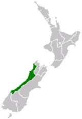
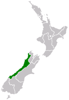
The West Coast is one of the administrative regions of New Zealand, located on the west coast of the South Island
South Island
The South Island is the larger of the two major islands of New Zealand, the other being the more populous North Island. It is bordered to the north by Cook Strait, to the west by the Tasman Sea, to the south and east by the Pacific Ocean...
, and is one of the more remote and most sparsely populated areas of the country. It is made up of three districts: Buller
Buller District
200px|rightBuller District, administered by the Buller District Council is an administrative region in the West Coast Region of New Zealand. It covers Westport, Karamea, Reefton and Inangahua Junction. Its land area is 7,953.12 km²...
, Grey
Grey District
Grey District Council in the West Coast region of New Zealand is a municipality that covers Greymouth, Runanga, Blackball, Cobden and settlements along the Grey River. It has a land area of 3,516.48 km²...
and Westland
Westland District
Westland District is a territorial authority on the west coast of New Zealand's South Island. Its population is - Government :The Westland District is governed by an elected Council, headed by an elected Mayor. The Mayor is elected at large. The current Mayor is Maureen Pugh. Councillors are...
. The principal towns are Westport
Westport, New Zealand
-Economy:Economic activity is based around fishing, coal mining and dairy farming. Historically, gold mining was a major industry, and coal mining was much more extensive than today . However, the region still is home to New Zealand's largest opencast mining operation in Stockton...
, Greymouth
Greymouth
Greymouth is the largest town in the West Coast region in the South Island of New Zealand, and the seat of the Grey District Council. The population of the whole Grey District is , which accounts for % of the West Coast's inhabitants...
and Hokitika
Hokitika, New Zealand
Hokitika is a township in the West Coast Region of New Zealand's South Island, south of Greymouth, and close to the mouth of the Hokitika River. According to the 2006 census, the usually resident population of the Hokitika urban area was 3,078, a decrease of 12 people since 2001. A further 828...
.
Naming
- To New Zealanders, 'The Coast' generally refers to the West Coast of the South IslandSouth IslandThe South Island is the larger of the two major islands of New Zealand, the other being the more populous North Island. It is bordered to the north by Cook Strait, to the west by the Tasman Sea, to the south and east by the Pacific Ocean...
, and 'Coasters' to those that live there.
- 'WestlandWestland DistrictWestland District is a territorial authority on the west coast of New Zealand's South Island. Its population is - Government :The Westland District is governed by an elected Council, headed by an elected Mayor. The Mayor is elected at large. The current Mayor is Maureen Pugh. Councillors are...
' is used by some New Zealanders to refer to the whole of the West Coast, including Grey DistrictGrey DistrictGrey District Council in the West Coast region of New Zealand is a municipality that covers Greymouth, Runanga, Blackball, Cobden and settlements along the Grey River. It has a land area of 3,516.48 km²...
, Buller DistrictBuller District200px|rightBuller District, administered by the Buller District Council is an administrative region in the West Coast Region of New Zealand. It covers Westport, Karamea, Reefton and Inangahua Junction. Its land area is 7,953.12 km²...
, and FiordlandFiordlandFiordland is a geographic region of New Zealand that is situated on the south-western corner of the South Island, comprising the western-most third of Southland. Most of Fiordland is dominated by the steep sides of the snow-capped Southern Alps, deep lakes and its ocean-flooded, steep western valleys...
, and can also refer to the short-lived Westland ProvinceWestland ProvinceThe Westland Province was a province of New Zealand from 1873 until the abolition of provincial government in 1876. The capital was Hokitika.-Area:...
of 1873–76.
- FiordlandFiordlandFiordland is a geographic region of New Zealand that is situated on the south-western corner of the South Island, comprising the western-most third of Southland. Most of Fiordland is dominated by the steep sides of the snow-capped Southern Alps, deep lakes and its ocean-flooded, steep western valleys...
is geographically on the west coast of New Zealand but has no direct road connection, and is in the SouthlandSouthland RegionSouthland is New Zealand's southernmost region and is also a district within that region. It consists mainly of the southwestern portion of the South Island and Stewart Island / Rakiura...
rather than West Coast administrative regionRegions of New ZealandThe region is the top tier of local government in New Zealand. There are 16 regions of New Zealand. Eleven are governed by an elected regional council, while five are governed by territorial authorities which also perform the functions of a regional council and thus are known as unitary authorities...
.
Geography
Kahurangi Point
Kahurangi Point is a headland on the West Coast of New Zealand's South Island, overlooking the Tasman Sea. It is located in Kahurangi National Park between Karamea and Farewell Spit....
in the north to Awarua Point
Awarua Point
Awarua Point is located on the southwestern coast of New Zealand's South Island, 40 kilometres north of Milford Sound, and 15 kilometres north of the mouth of the Hollyford River....
in the south, a distance of 600 km. To the west is the Tasman Sea
Tasman Sea
The Tasman Sea is the large body of water between Australia and New Zealand, approximately across. It extends 2,800 km from north to south. It is a south-western segment of the South Pacific Ocean. The sea was named after the Dutch explorer Abel Janszoon Tasman, the first recorded European...
(which like the Southern Ocean
Southern Ocean
The Southern Ocean comprises the southernmost waters of the World Ocean, generally taken to be south of 60°S latitude and encircling Antarctica. It is usually regarded as the fourth-largest of the five principal oceanic divisions...
is known to be very rough, with 4 metre swells being common), and to the east are the Southern Alps
Southern Alps
The Southern Alps is a mountain range extending along much of the length of New Zealand's South Island, reaching its greatest elevations near the island's western side...
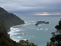
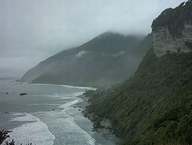
. Much of the land is rugged, although there are coastal plains around which much of the population resides.
The land is very scenic, with wild coastlines, mountains, and a very high proportion of native bush
Forest
A forest, also referred to as a wood or the woods, is an area with a high density of trees. As with cities, depending where you are in the world, what is considered a forest may vary significantly in size and have various classification according to how and what of the forest is composed...
, much of it native temperate rain forest. The West Coast is the only part of New Zealand where significant tracts of lowland forest remain-elsewhere, for instance on the Canterbury Plains
Canterbury Plains
The Canterbury Plains are an area in New Zealand centred to the south of the city of Christchurch in the Canterbury Region. Their northern extremes are at the foot of the Hundalee Hills in the Hurunui District, and in the south they merge into the plains of North Otago beyond the Waitaki...
and in the Firth of Thames
Firth of Thames
The Firth of Thames is a large bay located in the north of the North Island of New Zealand. It is the firth of the rivers Waihou and Piako, the former of which was formerly named the Thames River, and the town of Thames lies on its southeastern coast....
, they have been almost completely destroyed for settlement and agriculture. Scenic areas include the Haast Pass
Haast Pass
Haast Pass is a mountain pass in the Southern Alps of the South Island of New Zealand. It is named for Julius von Haast, a 19th century explorer who was also geologist for the Provincial government of Canterbury...
, Fox
Fox Glacier
The Fox Glacier is a long glacier located in Westland Tai Poutini National Park on the West Coast of New Zealand's South Island...
and Franz Josef Glacier
Franz Josef Glacier
The Franz Josef is a long glacier located in Westland Tai Poutini National Park on the West Coast of New Zealand's South Island...
s, the Pancake Rocks at Punakaiki
Punakaiki
Punakaiki is a small community on the West Coast of the South Island of New Zealand, between Westport and Greymouth. The community lies on the edge of the Paparoa National Park....
and the Heaphy Track
Heaphy Track
The Heaphy Track is a popular tramping track in the north west of the South Island of New Zealand. It is located within the Kahurangi National Park and classified as one of New Zealand's nine Great Walks by the Department of Conservation. Named after Charles Heaphy, the track is 82 km long and...
.
The region has a very high rainfall due to the prevailing northwesterly wind pattern and the location of the Southern Alps – these two elements give rise to heavy orographic precipitation
Precipitation (meteorology)
In meteorology, precipitation In meteorology, precipitation In meteorology, precipitation (also known as one of the classes of hydrometeors, which are atmospheric water phenomena is any product of the condensation of atmospheric water vapor that falls under gravity. The main forms of precipitation...
. The flip side to this is the rain shadow
Rain shadow
A rain shadow is a dry area on the lee side of a mountainous area. The mountains block the passage of rain-producing weather systems, casting a "shadow" of dryness behind them. As shown by the diagram to the right, the warm moist air is "pulled" by the prevailing winds over a mountain...
effect which is responsible for the relatively arid climate of the Canterbury Plains on the other side of the Southern Alps.
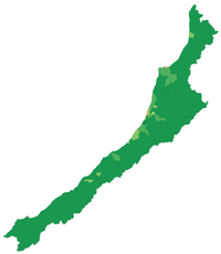
The region's area is 23,000 km². It is divided into the three districts
Territorial authorities of New Zealand
Territorial authorities are the second tier of local government in New Zealand, below regional councils. There are 67 territorial authorities: 13 city councils, 53 district councils, and the Chatham Islands Council...
of Buller, Grey and Westland.
Economy
The sub-national GDP of the West Coast region was estimated at US$779 million in 2003, 1% of New Zealand's national GDP.History
Taonga
A taonga in Māori culture is a treasured thing, whether tangible or intangible. Tangible examples are all sorts of heirlooms and artefacts, land, fisheries, natural resources such as geothermal springs and access to natural resources, such as riparian water rights and access to the riparian zone of...
of greenstone (pounamu) which was found there in abundance.
The West Coast was only occasionally visited by early Europeans until the discovery of gold
Gold
Gold is a chemical element with the symbol Au and an atomic number of 79. Gold is a dense, soft, shiny, malleable and ductile metal. Pure gold has a bright yellow color and luster traditionally considered attractive, which it maintains without oxidizing in air or water. Chemically, gold is a...
near the Taramakau River in 1864 by two Māori, Ihaia Tainui and Haimona Taukau. By the end of the year there were an estimated 1800 prospectors on the West Coast, many of them around the Hokitika area, which, in 1866, became briefly the most populous settlement in New Zealand.
The present-day region of the West Coast was divided between Nelson Province
Nelson Province
The Nelson Province was a province of New Zealand from 1853 until the abolition of provincial government in 1876.-History:The Marlborough Province split away from the Nelson Province on 1 November 1859 because the majority of the income of the Provincial Council came from land sales in the...
and Canterbury Province
Canterbury Province
The Canterbury Province was a province of New Zealand from 1853 until the abolition of provincial government in 1876. On the east coast the province was bounded by the Hurunui River in the north and the Waitaki River in the south...
from 1853, but in 1873 the Canterbury portion of the region formed its own province, the Westland Province
Westland Province
The Westland Province was a province of New Zealand from 1873 until the abolition of provincial government in 1876. The capital was Hokitika.-Area:...
, until the abolition of the provincial system in 1876.
The West Coast Gold Rush
West Coast Gold Rush
The West Coast Gold Rush on the West Coast of New Zealand from 1864 to 1867 populated the area, which up till then had been visited by few Europeans. Gold was found near the Taramakau River in 1864 by two Māori, Ihaia Tainui and Haimona Taukau...
between 1864 and 1867 created numerous gold rush towns such as Okarito which at one time was the largest town on the West Coast but then quickly almost vanished as miners moved on. After that time, the population dwindled, but the main towns that still exist on the coast had become established.
Following pounamu and gold, the next mineral to make the West Coast valuable was coal. Discovered near the Buller River
Buller River
The Buller River is in the South Island of New Zealand. One of the country's longest rivers, it flows for 170 kilometres from Lake Rotoiti through the Buller Gorge and into the Tasman Sea near the town of Westport...
in the mid 1840s, mining began in earnest during the 1860s. By the 1880s, coal had become the region’s main industry, with mines throughout the northern half of the region, especially around Westport
Westport, New Zealand
-Economy:Economic activity is based around fishing, coal mining and dairy farming. Historically, gold mining was a major industry, and coal mining was much more extensive than today . However, the region still is home to New Zealand's largest opencast mining operation in Stockton...
. Many of these continued in operation until the mid 20th century, and several survive today.
Timber has also long been a major industry in the region, although in recent years there has been an uneasy balance between forestry for wood and forestry for conservation. Much of the region is public land administered by the Department of Conservation
New Zealand Department of Conservation
The Department of Conservation , commonly known by its acronym, "DOC", is the state sector organisation which deals with the conservation of New Zealand’s natural and historic heritage...
and the region has some of the best remaining stands of native forest, along with a wealth of rare wildlife. Ecotourism
Ecotourism
Ecotourism is a form of tourism visiting fragile, pristine, and usually protected areas, intended as a low impact and often small scale alternative to standard commercial tourism...
is now an important industry in the region, and this goes hand in hand with the conservation efforts.
Human
Major towns on the West Coast are Greymouth, Westport
Westport, New Zealand
-Economy:Economic activity is based around fishing, coal mining and dairy farming. Historically, gold mining was a major industry, and coal mining was much more extensive than today . However, the region still is home to New Zealand's largest opencast mining operation in Stockton...
, and Hokitika
Hokitika, New Zealand
Hokitika is a township in the West Coast Region of New Zealand's South Island, south of Greymouth, and close to the mouth of the Hokitika River. According to the 2006 census, the usually resident population of the Hokitika urban area was 3,078, a decrease of 12 people since 2001. A further 828...
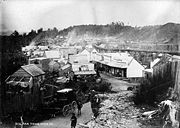
. At one time, during the gold rush days, Hokitika had a population of more than 25,000 and boasted more than 100 pubs. A recreation of an early New Zealand
History of New Zealand
The history of New Zealand dates back at least 700 years to when it was discovered and settled by Polynesians, who developed a distinct Māori culture centred on kinship links and land. The first European explorer to discover New Zealand was Abel Janszoon Tasman on 13 December 1642...
settlement can be found at Shantytown
Shantytown, New Zealand
Shantytown is a tourist attraction in the West Coast Region of the South Island of New Zealand. Located ten kilometres south of Greymouth, the town was constructed and opened in the early 1970s and consists of some thirty re-created historic buildings making up a 19th century gold-mining town...
.
Industries on the West Coast include mining
Mining
Mining is the extraction of valuable minerals or other geological materials from the earth, from an ore body, vein or seam. The term also includes the removal of soil. Materials recovered by mining include base metals, precious metals, iron, uranium, coal, diamonds, limestone, oil shale, rock...
for coal
Coal
Coal is a combustible black or brownish-black sedimentary rock usually occurring in rock strata in layers or veins called coal beds or coal seams. The harder forms, such as anthracite coal, can be regarded as metamorphic rock because of later exposure to elevated temperature and pressure...
and alluvial
Placer deposit
In geology, a placer deposit or placer is an accumulation of valuable minerals formed by gravity separation during sedimentary processes. The name is from the Spanish word placer, meaning "alluvial sand". Placer mining is an important source of gold, and was the main technique used in the early...
gold
Gold
Gold is a chemical element with the symbol Au and an atomic number of 79. Gold is a dense, soft, shiny, malleable and ductile metal. Pure gold has a bright yellow color and luster traditionally considered attractive, which it maintains without oxidizing in air or water. Chemically, gold is a...
, forestry
Forestry
Forestry is the interdisciplinary profession embracing the science, art, and craft of creating, managing, using, and conserving forests and associated resources in a sustainable manner to meet desired goals, needs, and values for human benefit. Forestry is practiced in plantations and natural stands...
and wood processing, and also fishing
Fishing
Fishing is the activity of trying to catch wild fish. Fish are normally caught in the wild. Techniques for catching fish include hand gathering, spearing, netting, angling and trapping....
(including whitebait
Whitebait
Whitebait is a collective term for the immature fry of fish, typically between 25 and 50 millimetres long. Such young fish often travel together in schools along the coast, and move into estuaries and sometimes up rivers where they can be easily caught with fine meshed fishing nets...
ing), tourism
Tourism
Tourism is travel for recreational, leisure or business purposes. The World Tourism Organization defines tourists as people "traveling to and staying in places outside their usual environment for not more than one consecutive year for leisure, business and other purposes".Tourism has become a...
and farming. Dairy farming has grown strongly – the local dairy co-operative Westland Milk Products
Westland Milk Products
Westland Milk Products is the trading name of Westland Co-operative Dairy Company Limited, an independent co-operative dairy company. It is owned by over 340 farmer shareholders, who supply milk to the factory for processing...
remained independent when most others merged to form Fonterra
Fonterra
Fonterra Co-operative Group Limited is a New Zealand multinational dairy co-operative owned by almost 10,500 New Zealand farmers. The company is responsible for approximately 30% of the world's dairy exports and with revenue exceeding NZ$19.87 billion, is New Zealand's largest company.- History :In...
in 2001.
Other industries are the manufacturing and sales of greenstone jewellery, sphagnum moss gathering and stone-collection for garden landscaping. The West Coast also has one of the strongest growing regional economies of New Zealand, as of 2007, though from a rather small base.
The West Coast has been numbered amongst the "Top 10 Coastal Drives of the World" by Lonely Planet
Lonely Planet
Lonely Planet is the largest travel guide book and digital media publisher in the world. The company is owned by BBC Worldwide, which bought a 75% share from the founders Maureen and Tony Wheeler in 2007 and the final 25% in February 2011...
.
Flora and fauna
The West Coast is also notable for being the only New Zealand nesting place of the White Heron / KotukuEastern Great Egret
The Eastern Great Egret is a white heron of the genus Ardea, is considered a subspecies of the Great Egret . Although a study argued for full species status in 2005, most taxonomists consider it to be a subspecies...
, which nests near the Okarito Lagoon
Okarito Lagoon
Okarito Lagoon is a coastal lagoon on the West Coast of New Zealand's South Island. It is located 130 kilometres south of Hokitika, and covers an area of about 12 km², making it the largest unmodified wetland in New Zealand....
and can be visited from tours operating out of the small farming township of Whataroa. This rare bird appears on the New Zealand $2 coin.