

Mosgiel
Encyclopedia
Mosgiel is an urban satellite of Dunedin
in Otago
, New Zealand
, fifteen kilometres west of the city's centre. Since the re-organisation of New Zealand local government
in 1989 it has been inside the Dunedin City Council area, but was physically separate from the contiguous suburbs until developments in the neighbouring suburb of Fairfield joined it to the city. Mosgiel has a population of approximately 10,000.
Mosgiel stands at the north-eastern extremity of the Taieri Plains
. The Silver Stream
, a tributary of the Taieri River
, runs through its north end. The town celebrates its location, calling itself "The pearl of the plain". Its low-lying nature does pose problems, making it prone to flooding after heavy rains.
The place takes its name from Mossgiel
in Ayrshire
, the farm of the poet Robert Burns
, the uncle of the co-founder in 1848 of the Otago
settlement, the Reverend Thomas Burns
. A popular, though probably apocryphal, local theory is that the extra "s" was dropped at a time when the cost of telegrams was calculated by the number of characters. The name of the Dunedin suburb of Roslyn (named for Rosslyn in Scotland) is similarly truncated. These two places were sites of major woollen mills - as was the town of Milton 40 kilometres (24.9 mi) to the south, where name may originally have been Milltown. Whether there is any connection between the location of the mills and name truncation, or whether it is a mere coincidence, is unknown.
Between Mosgiel and the centre of Dunedin stand the rugged Three Mile Hill and Scroggs Hill, which form part of the crater-wall of a long-extinct volcano, the crater being the Otago Harbour
. To the south of the town lies one of the many peaks that formed part of the volcano: Saddle Hill, a prominent landmark, visible from a considerable distance and notable for its distinctive shape, lies east of State Highway One where Kinmont Park, a new housing subdivision is located at the foot of the hill.
The Dunedin Southern Motorway
, upgraded in 2003, links Mosgiel with the centre of Dunedin. State Highway 87
to Kyeburn starts at a junction with State Highway 1 at the southeastern edge of Mosgiel, the first part of the highway being the main street of Mosgiel, Gordon Road.
 The site of Mosgiel figures in Māori legend, but surrounding features of the Taieri Plain and adjacent hills have older mythical associations. Of the canoes of South Island migratory legend the fourth and fifth, Takitimu
and Arai Te Uru, are mentioned in connection with the area. Maungatua
, the large hill to the west of the plain, represents a huge wave which struck the Takitimu, throwing overboard Aonui, who became a pillar on the Tokomairiro
Beach. Another account makes Aonui a female survivor of the wreck of the Arai Te Uru, built by Kahui Tipua, who had arrived earlier but sent this vessel to the Polynesia
n homeland Hawaiki
to get kumara
. On its return the canoe suffered shipwreck at Shag Point
in North Otago
, but its survivors quested about the land in search of supplies. If they failed to get back before dawn they turned into natural landscape-features, and this fate befell Aonui. These ancient traditions suggest that some of the earliest Polynesian settlers in the south knew the Taieri Plain.
W.R. Kirk repeated the later story of a taniwha
(water-monster), the "familiar spirit or guardian of Te Rakitaounere (also given as Te Rakitauneke) a famous chief and warrior" who lost his master about the Dunedin hills, slithered down the Silverstream, 'Whaka-ehu', and 'lay down and left a hollow Te Konika o te Matamata' on the site of Mosgiel. The taniwha (named Matamata) wriggled down the Taieri, making its tortuous course, and when he died became the seaboard hills, including Saddle Hill. This story has associations with Kati Mamoe
, ('Ngati Mamoe' in modern standard Māori) of the late 17th or early 18th century. According to tradition this period also saw the occupation of the kaik (unfortified settlement) near modern Henley
- called Tai-ari like the river - and on the hill above it a pa
, or fortified settlement, called Omoua. Tukiauau built a pa called Whakaraupuka on the west side of Lake Waihola
and his rival, Tuwiriroa, came down from Lake Wakatipu
and built one at Taieri Mouth
on the coast. Māori soon abandoned Whakaraupuka, but the Taiari settlement at Henley endured into modern times. (Anderson, 1998.)
In February 1770 Captain James Cook
described the saddle-shaped hill which became known as Saddle Hill, the landmark east of Mosgiel. The Weller brothers
of the Otago whaling station on Otago Harbour
(modern Otakou
) sent a Mr. Dalziel to inspect the Taieri Plain for a proposed Scottish settlement in 1839, but he gave an unfavourable report. In 1844 Edward Shortland noticed Māori running pigs on the landward slopes of Saddle Hill orMakamaka (as he recorded the hill's Māori name). Charles Kettle
surveyed the plain and coastal hills for the Otago Association in 1846 and 1847. He also climbed the westward hills and saw the raised land beyond, the nearest approach of the Central Otago
plateau to the sea, which he correctly identified as potentially fine pastoral
country.
Following the arrival of the Association's settlers at Dunedin in 1848, a Scots shepherd, Jaffray, brought his wife and dogs along the Māori track from Kaikorai Valley
and settled on Saddle Hill in a whare (a Māori-style house) in 1849, establishing the first European farmstead in the district. In the same year the Reverend Thomas Burns
, spiritual leader of the Association's settlement, selected the land which would become Mosgiel.
In the mid-1850s Arthur John Burns
, a son of Thomas Burns
, settled on some of the land. A large stand of native bush
stood nearby. The richness of the land and the proximity of the main south road, more or less following the route of an old Māori track, led to early close rural settlement.
The 1861 Otago gold rush saw the development of a road — leading west to the interior — which intersected the site. Arthur John Burns
's establishment of the Mosgiel Woollen Company and mill in 1871 brought the settlement of workers in cottages. 1875 saw the north-south road paralleled by a railway, with a branch to the west constructed in 1877. The authorities declared the Mosgiel Town District in 1882 and constituted a Borough
Council in 1885. The town grew and became the most substantial in the district. The surrounding plain became a sort of Home County
to Dunedin, a place of prosperous farms and of the large houses of successful businessmen with rural tastes. Horse-breeding and racing flourished.
 From 1900 to 1997, Mosgiel was the site of Holy Cross College
, the national Roman Catholic seminary for the training of priests. The seminary was located in extensive grounds which included a farm. The seminary was shifted to Auckland
in 1997 but many of its buildings remain and are used for Catholic and other purposes.
The significance of the area for transport grew in the 20th century when the proximity of the plain's flat land to Dunedin saw the establishment of the Taieri Aerodrome, just north of Mosgiel, in the late 1920s and the development of Momona
Airport, now Dunedin International Airport
, further south on the plain in 1962.
After the Second World War some expected Mosgiel might industrialise extensively, like the Hutt Valley, but expansion remained limited. The bankruptcy of the woollen mill in 1980 and its eventual closure has not been offset by other industrial developments.
The late 20th century's increasingly ageing New Zealand population saw the expansion of housing for the elderly, with several retirement villages and communities located in the vicinity. In recent decades the hills above the plain have seen some division into lifestyle blocks. The 2003 completion of the Fairfield bypass shortened commuting-time via the southern motorway (part of State Highway 1
) to the city centre.
Mosgiel's economy until years focused on the manufacture of wool-products and many elderly New Zealanders associate the word "Mosgiel" with the former Mosgiel Woollen Mills. , Mosgiel's income comes from many sources, including local shops, cafés and bars. It remains an important service-centre for the surrounding farming community. It also hosts one of New Zealand's largest agricultural research institutes, Invermay
. Until recently the largest employer was Fisher & Paykel
which manufactured DishDrawer
dishwasher and ranges at their Mosgiel factory. The closure of this plant was announced in early 2008.
 R.A. Lawson's East Taieri Presbyterian Church (1870) stands near the Mosgiel turnoff to State Highway 1.
H.F. Hardy's 1870s and 1880s buildings for the Mosgiel Woollen Mill stand in Factory Road, Mosgiel.
In 1936, while still a schoolboy, the artist Colin McCahon
took part in a family outing, driving from the seaboard over the coastal hills. Looking across the Taieri Plain towards Central Otago he had what he described as a "vision", seeing a pre-Biblical "landscape of splendour order and peace" — which, he said, it became his life's work to communicate. The same view, though seen from a greater distance, had inspired Charles Kettle
in the 1840s.
In 1953 the young Ralph Hotere
, later to become one of New Zealand's best-regarded artists, qualified as a pilot on Tiger Moth
s at the Taieri Aerodrome Training School, Mosgiel.
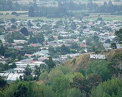
Mosgiel's sign forms an unusual feature. Modelled on the famous Hollywood Sign
, the seven letters of the Mosgiel sign perch on a hillside close to State Highway 1. Because of this sign locals sometimes (though not very often) jokingly refer to Mosgiel as "Mollywood
".
The distinctive outline of Saddle Hill
forms the eastern border of the greater Mosgiel area.
In years Mosgiel has experienced increased urbanisation and a growth in population. The revival has come about in part due to people moving from Dunedin's inner suburbs. Mosgiel has seen the opening or refurbishment of cafés and bars aimed at a younger market, and workers have built stages one and two of a planned larger playground.
Mosgiel has recently become home to the first Warehouse Local store, and a McDonalds restaurant was planned to go next to New World, however due to strict restrictions that would be imposed on the restaurant the idea has been scrapped.
Dunedin
Dunedin is the second-largest city in the South Island of New Zealand, and the principal city of the Otago Region. It is considered to be one of the four main urban centres of New Zealand for historic, cultural, and geographic reasons. Dunedin was the largest city by territorial land area until...
in Otago
Otago
Otago is a region of New Zealand in the south of the South Island. The region covers an area of approximately making it the country's second largest region. The population of Otago is...
, New Zealand
New Zealand
New Zealand is an island country in the south-western Pacific Ocean comprising two main landmasses and numerous smaller islands. The country is situated some east of Australia across the Tasman Sea, and roughly south of the Pacific island nations of New Caledonia, Fiji, and Tonga...
, fifteen kilometres west of the city's centre. Since the re-organisation of New Zealand local government
Local government
Local government refers collectively to administrative authorities over areas that are smaller than a state.The term is used to contrast with offices at nation-state level, which are referred to as the central government, national government, or federal government...
in 1989 it has been inside the Dunedin City Council area, but was physically separate from the contiguous suburbs until developments in the neighbouring suburb of Fairfield joined it to the city. Mosgiel has a population of approximately 10,000.
Mosgiel stands at the north-eastern extremity of the Taieri Plains
Taieri Plains
The Taieri Plains are an area of fertile agricultural land to the southwest of Dunedin, in Otago, New Zealand. The plains cover an area of some 300 square kilometres, with a maximum extent of 30 kilometres....
. The Silver Stream
Silver Stream, New Zealand
The Silver Stream is a small river flowing close to the town of Mosgiel in Otago, New Zealand.The Silver Stream rises in the Silverpeaks hills north of Dunedin, on the southern slope of Silver Peak itself, and flows initially southwards through a steep-sided forested valley before turning west at...
, a tributary of the Taieri River
Taieri River
The Taieri River is the fourth-longest river in New Zealand and is located in Otago in the South Island. Rising in the Lammerlaw ranges, it initially flows north, then east around the Rock and Pillar range before turning southeast, reaching the sea 30 km south of Dunedin.The upper reaches meander...
, runs through its north end. The town celebrates its location, calling itself "The pearl of the plain". Its low-lying nature does pose problems, making it prone to flooding after heavy rains.
The place takes its name from Mossgiel
Mossgiel
Mossgiel can refer to:*Mossgiel Farm, Ayrshire, Scotland - home of poet Robert Burns*Mossgiel, New South Wales, named after Burns's farm...
in Ayrshire
Ayrshire
Ayrshire is a registration county, and former administrative county in south-west Scotland, United Kingdom, located on the shores of the Firth of Clyde. Its principal towns include Ayr, Kilmarnock and Irvine. The town of Troon on the coast has hosted the British Open Golf Championship twice in the...
, the farm of the poet Robert Burns
Robert Burns
Robert Burns was a Scottish poet and a lyricist. He is widely regarded as the national poet of Scotland, and is celebrated worldwide...
, the uncle of the co-founder in 1848 of the Otago
Otago
Otago is a region of New Zealand in the south of the South Island. The region covers an area of approximately making it the country's second largest region. The population of Otago is...
settlement, the Reverend Thomas Burns
Thomas Burns (New Zealand)
Thomas Burns was a prominent early European settler and religious leader of the province of Otago, New Zealand.Burns was baptised at Mauchline, Ayrshire, Scotland in April 1796, the son of estate manager Gilbert Burns, who was the brother of the poet Robert Burns...
. A popular, though probably apocryphal, local theory is that the extra "s" was dropped at a time when the cost of telegrams was calculated by the number of characters. The name of the Dunedin suburb of Roslyn (named for Rosslyn in Scotland) is similarly truncated. These two places were sites of major woollen mills - as was the town of Milton 40 kilometres (24.9 mi) to the south, where name may originally have been Milltown. Whether there is any connection between the location of the mills and name truncation, or whether it is a mere coincidence, is unknown.
Between Mosgiel and the centre of Dunedin stand the rugged Three Mile Hill and Scroggs Hill, which form part of the crater-wall of a long-extinct volcano, the crater being the Otago Harbour
Otago Harbour
Otago Harbour is the natural harbour of Dunedin, New Zealand, consisting of a long, much-indented stretch of generally navigable water separating the Otago Peninsula from the mainland. They join at its southwest end, from the harbour mouth...
. To the south of the town lies one of the many peaks that formed part of the volcano: Saddle Hill, a prominent landmark, visible from a considerable distance and notable for its distinctive shape, lies east of State Highway One where Kinmont Park, a new housing subdivision is located at the foot of the hill.
The Dunedin Southern Motorway
Dunedin Southern Motorway
The Dunedin Southern Motorway is the main arterial route south from the South Island city of Dunedin, part of New Zealand's State Highway 1. It is one of the world's southernmost motorways.-Route:...
, upgraded in 2003, links Mosgiel with the centre of Dunedin. State Highway 87
New Zealand State Highway 87
State Highway 87 is a State Highway in New Zealand servicing the Taieri Plains and the Strath-Taieri Valley in Otago, connecting Mosgiel to Kyeburn on the eastern flank of the Maniototo Plains....
to Kyeburn starts at a junction with State Highway 1 at the southeastern edge of Mosgiel, the first part of the highway being the main street of Mosgiel, Gordon Road.
Legend and early history
Takitimu
In several Māori traditions, the Tākitimu was one of the great Māori migration canoes that brought Polynesian migrants to New Zealand from Hawaiki. It was one of the seven canoes in the "Great Fleet hypothesis" proposed by historian Stephenson Percy Smith .-Māori Traditions:The Tākitimu appears in...
and Arai Te Uru, are mentioned in connection with the area. Maungatua
Maungatua
Often incorrectly called The Maungatuas or The Maungatua Range, Maungatua is a prominent ridge which dominates the skyline of the Taieri Plains in Otago, New Zealand...
, the large hill to the west of the plain, represents a huge wave which struck the Takitimu, throwing overboard Aonui, who became a pillar on the Tokomairiro
Tokomairiro River
The Tokomairiro River is located in Otago, New Zealand. It flows southeast for some 50 kilometres , reaching the Pacific Ocean at Toko Mouth 50 kilometres south of Dunedin...
Beach. Another account makes Aonui a female survivor of the wreck of the Arai Te Uru, built by Kahui Tipua, who had arrived earlier but sent this vessel to the Polynesia
Polynesia
Polynesia is a subregion of Oceania, made up of over 1,000 islands scattered over the central and southern Pacific Ocean. The indigenous people who inhabit the islands of Polynesia are termed Polynesians and they share many similar traits including language, culture and beliefs...
n homeland Hawaiki
Hawaiki
In Māori mythology, Hawaiki is the homeland of the Māori, the original home of the Māori, before they travelled across the sea to New Zealand...
to get kumara
Sweet potato
The sweet potato is a dicotyledonous plant that belongs to the family Convolvulaceae. Its large, starchy, sweet-tasting, tuberous roots are an important root vegetable. The young leaves and shoots are sometimes eaten as greens. Of the approximately 50 genera and more than 1,000 species of...
. On its return the canoe suffered shipwreck at Shag Point
Shag Point
Shag Point is a point between Camp Bay and Sunset Fjord in the Bay of Isles, on the north coast of South Georgia. The name appears to be first used on a 1931 British Admiralty chart....
in North Otago
North Otago
The district of North Otago in New Zealand covers the area of Otago between Shag Point and the Waitaki River, and extends inland to the west as far as the village of Omarama . The large east-coast town of Oamaru serves as North Otago's main centre...
, but its survivors quested about the land in search of supplies. If they failed to get back before dawn they turned into natural landscape-features, and this fate befell Aonui. These ancient traditions suggest that some of the earliest Polynesian settlers in the south knew the Taieri Plain.
W.R. Kirk repeated the later story of a taniwha
Taniwha
In Māori mythology, taniwha are beings that live in deep pools in rivers, dark caves, or in the sea, especially in places with dangerous currents or deceptive breakers...
(water-monster), the "familiar spirit or guardian of Te Rakitaounere (also given as Te Rakitauneke) a famous chief and warrior" who lost his master about the Dunedin hills, slithered down the Silverstream, 'Whaka-ehu', and 'lay down and left a hollow Te Konika o te Matamata' on the site of Mosgiel. The taniwha (named Matamata) wriggled down the Taieri, making its tortuous course, and when he died became the seaboard hills, including Saddle Hill. This story has associations with Kati Mamoe
Kati Mamoe
Kāti Mamoe, or Ngāti Mamoe, is an historic Māori iwi. Originally from the Heretaunga area they moved in the 16th century to the South Island which at the time was occupied by Waitaha....
, ('Ngati Mamoe' in modern standard Māori) of the late 17th or early 18th century. According to tradition this period also saw the occupation of the kaik (unfortified settlement) near modern Henley
Henley, New Zealand
Henley is a township on New Zealand's Taieri Plains, presumably named after the rowing centre Henley-on-Thames in England. It lies close to the confluence of the Taieri and Waipori Rivers at the eastern edge of the plain, at the foot of a low range of coastal hills.Henley is near the south-west...
- called Tai-ari like the river - and on the hill above it a pa
Pa (Maori)
The word pā can refer to any Māori village or settlement, but in traditional use it referred to hillforts fortified with palisades and defensive terraces and also to fortified villages. They first came into being about 1450. They are located mainly in the North Island north of lake Taupo...
, or fortified settlement, called Omoua. Tukiauau built a pa called Whakaraupuka on the west side of Lake Waihola
Lake Waihola
Lake Waihola is a tidal freshwater lake located 15 km north of Milton in Otago, in New Zealand's South Island. Its area is some 9 square kilometres, with a maximum length of 6 kilometres....
and his rival, Tuwiriroa, came down from Lake Wakatipu
Lake Wakatipu
Lake Wakatipu is an inland lake in the South Island of New Zealand. It is in the southwest corner of Otago Region, near its boundary with Southland.With a length of , it is New Zealand's longest lake, and, at , its third largest...
and built one at Taieri Mouth
Taieri Mouth
Taieri Mouth is a small fishing village at the mouth of the Taieri River, New Zealand. Taieri Island lies in the ocean several hundred metres off the river's mouth.It has a white sand beach for swimming and several picnic areas...
on the coast. Māori soon abandoned Whakaraupuka, but the Taiari settlement at Henley endured into modern times. (Anderson, 1998.)
In February 1770 Captain James Cook
James Cook
Captain James Cook, FRS, RN was a British explorer, navigator and cartographer who ultimately rose to the rank of captain in the Royal Navy...
described the saddle-shaped hill which became known as Saddle Hill, the landmark east of Mosgiel. The Weller brothers
Weller brothers
The Weller brothers, Englishmen of Sydney and Otago, New Zealand, were the founders of a whaling station on Otago Harbour and New Zealand’s most substantial merchant traders in the 1830s.-Immigration:...
of the Otago whaling station on Otago Harbour
Otago Harbour
Otago Harbour is the natural harbour of Dunedin, New Zealand, consisting of a long, much-indented stretch of generally navigable water separating the Otago Peninsula from the mainland. They join at its southwest end, from the harbour mouth...
(modern Otakou
Otakou
The settlement of Otakou lies within the boundaries of the city of Dunedin, New Zealand. It is located 25 kilometres from the city centre at the eastern end of Otago Peninsula, close to the entrance of Otago Harbour.-Overview:...
) sent a Mr. Dalziel to inspect the Taieri Plain for a proposed Scottish settlement in 1839, but he gave an unfavourable report. In 1844 Edward Shortland noticed Māori running pigs on the landward slopes of Saddle Hill orMakamaka (as he recorded the hill's Māori name). Charles Kettle
Charles Kettle
Charles Henry Kettle surveyed the city of Dunedin in New Zealand, imposing a bold design on a challenging landscape. He was aiming to create a Romantic effect and incidentally produced the world's steepest street, Baldwin Street....
surveyed the plain and coastal hills for the Otago Association in 1846 and 1847. He also climbed the westward hills and saw the raised land beyond, the nearest approach of the Central Otago
Central Otago
Central Otago is the inland part of the New Zealand region of Otago in the South Island. The area commonly known as Central Otago includes both the Central Otago District and the Queenstown-Lakes District to the west....
plateau to the sea, which he correctly identified as potentially fine pastoral
Pastoralism
Pastoralism or pastoral farming is the branch of agriculture concerned with the raising of livestock. It is animal husbandry: the care, tending and use of animals such as camels, goats, cattle, yaks, llamas, and sheep. It may have a mobile aspect, moving the herds in search of fresh pasture and...
country.
Following the arrival of the Association's settlers at Dunedin in 1848, a Scots shepherd, Jaffray, brought his wife and dogs along the Māori track from Kaikorai Valley
Kaikorai Valley
Kaikorai Valley is a long broad valley which runs through the west of the New Zealand city of Dunedin, to the west of the city centre. It is the valley of a small stream, the Kaikorai Stream,which runs from northeast to southwest down the length of the valley.The valley provides a route into...
and settled on Saddle Hill in a whare (a Māori-style house) in 1849, establishing the first European farmstead in the district. In the same year the Reverend Thomas Burns
Thomas Burns (New Zealand)
Thomas Burns was a prominent early European settler and religious leader of the province of Otago, New Zealand.Burns was baptised at Mauchline, Ayrshire, Scotland in April 1796, the son of estate manager Gilbert Burns, who was the brother of the poet Robert Burns...
, spiritual leader of the Association's settlement, selected the land which would become Mosgiel.
In the mid-1850s Arthur John Burns
Arthur John Burns
Arthur John Burns was a prominent early settler of Otago, New Zealand, a member of the Otago Provincial Council, a member of the New Zealand House of Representatives and founder of the Mosgiel Woollen Company, Dunedin....
, a son of Thomas Burns
Thomas Burns (New Zealand)
Thomas Burns was a prominent early European settler and religious leader of the province of Otago, New Zealand.Burns was baptised at Mauchline, Ayrshire, Scotland in April 1796, the son of estate manager Gilbert Burns, who was the brother of the poet Robert Burns...
, settled on some of the land. A large stand of native bush
Rainforest
Rainforests are forests characterized by high rainfall, with definitions based on a minimum normal annual rainfall of 1750-2000 mm...
stood nearby. The richness of the land and the proximity of the main south road, more or less following the route of an old Māori track, led to early close rural settlement.
The 1861 Otago gold rush saw the development of a road — leading west to the interior — which intersected the site. Arthur John Burns
Arthur John Burns
Arthur John Burns was a prominent early settler of Otago, New Zealand, a member of the Otago Provincial Council, a member of the New Zealand House of Representatives and founder of the Mosgiel Woollen Company, Dunedin....
's establishment of the Mosgiel Woollen Company and mill in 1871 brought the settlement of workers in cottages. 1875 saw the north-south road paralleled by a railway, with a branch to the west constructed in 1877. The authorities declared the Mosgiel Town District in 1882 and constituted a Borough
Borough
A borough is an administrative division in various countries. In principle, the term borough designates a self-governing township although, in practice, official use of the term varies widely....
Council in 1885. The town grew and became the most substantial in the district. The surrounding plain became a sort of Home County
Home Counties
The home counties is a term which refers to the counties of South East England and the East of England which border London, but do not include the capital city itself...
to Dunedin, a place of prosperous farms and of the large houses of successful businessmen with rural tastes. Horse-breeding and racing flourished.
Mosgiel in the twentieth century
Holy Cross College (New Zealand)
Holy Cross College or Holy Cross Seminary is the national Roman Catholic seminary of New Zealand for the training of priests. It was first opened in 1900 in Mosgiel and was relocated to Auckland in 1997.-Establishment:...
, the national Roman Catholic seminary for the training of priests. The seminary was located in extensive grounds which included a farm. The seminary was shifted to Auckland
Auckland
The Auckland metropolitan area , in the North Island of New Zealand, is the largest and most populous urban area in the country with residents, percent of the country's population. Auckland also has the largest Polynesian population of any city in the world...
in 1997 but many of its buildings remain and are used for Catholic and other purposes.
The significance of the area for transport grew in the 20th century when the proximity of the plain's flat land to Dunedin saw the establishment of the Taieri Aerodrome, just north of Mosgiel, in the late 1920s and the development of Momona
Momona
Momona is a small town in New Zealand's South Island. It is located in the centre of the fertile floodplain of the Taieri River ....
Airport, now Dunedin International Airport
Dunedin International Airport
Dunedin International Airport is an international airport in the Otago region of the South Island of New Zealand, serving Dunedin city and the Otago and Southland regions. Dunedin International Airport is one of two international airports in Otago, the other being Queenstown International Airport...
, further south on the plain in 1962.
After the Second World War some expected Mosgiel might industrialise extensively, like the Hutt Valley, but expansion remained limited. The bankruptcy of the woollen mill in 1980 and its eventual closure has not been offset by other industrial developments.
The late 20th century's increasingly ageing New Zealand population saw the expansion of housing for the elderly, with several retirement villages and communities located in the vicinity. In recent decades the hills above the plain have seen some division into lifestyle blocks. The 2003 completion of the Fairfield bypass shortened commuting-time via the southern motorway (part of State Highway 1
State Highway 1 (New Zealand)
State Highway 1 is the longest and most significant road in the New Zealand roading network, running the length of both main islands. It appears on road maps as SH 1 and on road signs as a white number 1 on a red shield, but it has the official designations SH 1N in the North Island, SH 1S in the...
) to the city centre.
Mosgiel's economy until years focused on the manufacture of wool-products and many elderly New Zealanders associate the word "Mosgiel" with the former Mosgiel Woollen Mills. , Mosgiel's income comes from many sources, including local shops, cafés and bars. It remains an important service-centre for the surrounding farming community. It also hosts one of New Zealand's largest agricultural research institutes, Invermay
Invermay Agricultural Centre
Invermay Agricultural Centre is located close to Mosgiel, on the Taieri Plains in Otago, New Zealand. Part of AgResearch, it is a scientific research centre specialising in research into genomics,animal reproduction, land management and biosecurity....
. Until recently the largest employer was Fisher & Paykel
Fisher & Paykel
Fisher & Paykel is a major appliance manufacturing company based in East Tamaki, New Zealand.Originally an importer of domestic refrigerators, Fisher & Paykel now holds over 420 patents and bases its identity on innovative design, particularly in the areas of usability and environmental...
which manufactured DishDrawer
DishDrawer
A Drawer dishwasher is a type of dishwashing machine designed and manufactured by Fisher & Paykel. They are available under several brands depending on geographic location Fisher & Paykel, Kenmore Appliances, KitchenAid, and Bauknecht following a distribution agreement with Whirlpool.In 1987 Fisher...
dishwasher and ranges at their Mosgiel factory. The closure of this plant was announced in early 2008.
Points of interest
H.F. Hardy's 1870s and 1880s buildings for the Mosgiel Woollen Mill stand in Factory Road, Mosgiel.
In 1936, while still a schoolboy, the artist Colin McCahon
Colin McCahon
Colin John McCahon was a prominent New Zealand artist. During his life he also worked in art galleries and as a university lecturer...
took part in a family outing, driving from the seaboard over the coastal hills. Looking across the Taieri Plain towards Central Otago he had what he described as a "vision", seeing a pre-Biblical "landscape of splendour order and peace" — which, he said, it became his life's work to communicate. The same view, though seen from a greater distance, had inspired Charles Kettle
Charles Kettle
Charles Henry Kettle surveyed the city of Dunedin in New Zealand, imposing a bold design on a challenging landscape. He was aiming to create a Romantic effect and incidentally produced the world's steepest street, Baldwin Street....
in the 1840s.
In 1953 the young Ralph Hotere
Ralph Hotere
Hone Papita Raukura "Ralph" Hotere is a New Zealand artist of Māori descent . He was born in Mitimiti, Northland and He is widely regarded as one of New Zealand's most important living artists...
, later to become one of New Zealand's best-regarded artists, qualified as a pilot on Tiger Moth
Tiger moth
Tiger moths are moths of the family Arctiidae.Tiger moth may also refer to:*de Havilland Tiger Moth, an aircraft; an aerobatic and trainer tailwheel biplane*de Havilland DH.71 Tiger Moth, an earlier monoplane produced by de Havilland...
s at the Taieri Aerodrome Training School, Mosgiel.
Mosgiel's sign forms an unusual feature. Modelled on the famous Hollywood Sign
Hollywood Sign
The Hollywood Sign is a landmark and American cultural icon in the Hollywood Hills area of Mount Lee, Santa Monica Mountains, in Los Angeles, California. The sign spells out the name of the area in and white letters. It was created as an advertisement in 1923, but garnered increasing recognition...
, the seven letters of the Mosgiel sign perch on a hillside close to State Highway 1. Because of this sign locals sometimes (though not very often) jokingly refer to Mosgiel as "Mollywood
Hollywood-inspired names
Hollywood is such an iconic name that various other locations associated with the film industry are nicknamed with Hollywood-inspired names. Most starting with the first letter of the location and ending in the letters "-ollywood" or "-wood".-South Asia:...
".
The distinctive outline of Saddle Hill
Saddle Hill, New Zealand
Saddle Hill is a prominent landmark overlooking the northeastern end of the Taieri Plains in Otago, New Zealand. Within the limits of Dunedin city, it is located 18 kilometres to the west of the city centre, between Mosgiel and Green Island, and is clearly visible from many of the city's southern...
forms the eastern border of the greater Mosgiel area.
In years Mosgiel has experienced increased urbanisation and a growth in population. The revival has come about in part due to people moving from Dunedin's inner suburbs. Mosgiel has seen the opening or refurbishment of cafés and bars aimed at a younger market, and workers have built stages one and two of a planned larger playground.
Mosgiel has recently become home to the first Warehouse Local store, and a McDonalds restaurant was planned to go next to New World, however due to strict restrictions that would be imposed on the restaurant the idea has been scrapped.