

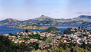
Port Chalmers
Encyclopedia
Dunedin
Dunedin is the second-largest city in the South Island of New Zealand, and the principal city of the Otago Region. It is considered to be one of the four main urban centres of New Zealand for historic, cultural, and geographic reasons. Dunedin was the largest city by territorial land area until...
, New Zealand
New Zealand
New Zealand is an island country in the south-western Pacific Ocean comprising two main landmasses and numerous smaller islands. The country is situated some east of Australia across the Tasman Sea, and roughly south of the Pacific island nations of New Caledonia, Fiji, and Tonga...
, with a population of 3,000. Port Chalmers lies ten kilometres inside Otago Harbour
Otago Harbour
Otago Harbour is the natural harbour of Dunedin, New Zealand, consisting of a long, much-indented stretch of generally navigable water separating the Otago Peninsula from the mainland. They join at its southwest end, from the harbour mouth...
, some 15 kilometres northeast from Dunedin's city centre.
Much of Port Chalmers is located on a small hilly peninsula, at the northern end of which is a large reclaimed area which is now the site of Dunedin's container port. Close to the southeastern shore of this peninsula are a pair of islands, which lie across the harbour between Port Chalmers and the Otago Peninsula
Otago Peninsula
The Otago Peninsula is a long, hilly indented finger of land that forms the easternmost part of Dunedin, New Zealand. Volcanic in origin, it forms one wall of the eroded valley that now forms Otago Harbour. The peninsula lies south-east of Otago Harbour and runs parallel to the mainland for...
. These two islands are Quarantine Island/Kamau Taurua and Goat Island
Goat Island, Otago Harbour
Goat Island / Rakiriri is an island in Otago Harbour in Otago, in the southern South Island of New Zealand. It is located between Port Chalmers and Portobello, to the northeast of Dunedin's city centre....
. Prior to the local body reorganisation in the 1980s Port Chalmers was made up of several suburbs, as well as the central area, Roseneath
Roseneath
Roseneath is the name of several places:*Roseneath, an historical mis-spelling of name of the village of Rosneath, Argyll and Bute, Scotland and from which a number of other place-names derivein Australia*Roseneath, Victoria, in Australia...
, Blanket Bay, Upper Junction, Brick Hill, Sawyers Bay
Sawyers Bay
Sawyers Bay is a suburb of the New Zealand city of Dunedin. It is located to the southwest of Port Chalmers in a wide valley on the shore of Mussel Bay, to the northeast of Dunedin city centre....
, Mussel Bay, Upper Port Chalmers, Dalkeith, Careys Bay, Reynoldstown, Deborah Bay, Hamilton Bay, Waipuna Bay, Te Ngaru, and Aramoana
Aramoana
Aramoana, also known as "The Spit" to locals, is a small coastal settlement, 27 kilometres north of Dunedin city, in the South Island of New Zealand. The settlement's permanent population in 2001 Census was 261. Supplementing this are seasonal visitors from the city who occupy cribs...
, as well as the outlying townships of Long Beach, Purakanui and several other smaller nearby villages and farmsteads.
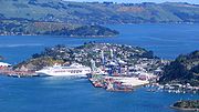
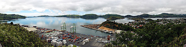
Although the harbour beyond Port Chalmers is regularly dredged, most of the port activity is centred on Port Chalmers rather than on central Dunedin. Part of the reason for this is the narrowness of the Victoria Channel, the one part of the Otago Harbour navigable by large ships, which makes it far easier for berthing to take place at Port Chalmers, closer to the open sea. Any big ships venturing into the upper harbour wharfs need to be piloted in with the help of tugs.
The port was the last visited by Robert Falcon Scott
Robert Falcon Scott
Captain Robert Falcon Scott, CVO was a Royal Navy officer and explorer who led two expeditions to the Antarctic regions: the Discovery Expedition, 1901–04, and the ill-fated Terra Nova Expedition, 1910–13...
before heading south on his final expedition to Antarctica. A large stone monument now stands above the town dedicated to Scott's final expedition.
Most of Port Chalmers' economic activity centres on the container terminal. Fishing, of historic importance, is now only a small part of the economy. The creative arts are also important to the area's economy; Port Chalmers and the surrounding suburbs of Careys Bay, Roseneath and Sawyers Bay have a thriving arts community, and the town is regarded as a haven for alternative lifestyle
Alternative lifestyle
An alternative lifestyle is a lifestyle generally perceived to be outside the cultural norm. Usually, but not always, it implies an affinity or identification within some matching subculture...
rs. Noted residents include Māori artist Ralph Hotere
Ralph Hotere
Hone Papita Raukura "Ralph" Hotere is a New Zealand artist of Māori descent . He was born in Mitimiti, Northland and He is widely regarded as one of New Zealand's most important living artists...
.
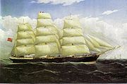
Port Chalmers was also the appellation of a ship which sailed between England, Australia and New Zealand at the beginning of the 20th century. It was torpedoed in mid-October 1940 and sunk, with some crew surviving 14 days at sea on the lifeboat.
History
According to Herries Beattie an old Māori name for Port Chalmers was 'Potakere' or 'Pou-takere' which may have indicated the hill where the tuahu, or altar, was sited. 'Koputai' is a later name and refers to an incident in which the tide rose and beached canoes were set adrift. When a peace was made between Kati Mamoe ('Ngati Mamoe' in modern standard Māori) and Kai Tahu ('Ngai TahuNgai Tahu
Ngāi Tahu, or Kāi Tahu, is the principal Māori iwi of the southern region of New Zealand, with the tribal authority, Te Rūnanga o Ngāi Tahu, being based in Christchurch and Invercargill. The iwi combines three groups, Kāi Tahu itself, and Waitaha and Kāti Mamoe who lived in the South Island prior...
' in modern standard Māori), about 1780, Koputai was one of two southern terminuses of Kai Tahu territory.
By February 1839 the Weller brothers
Weller brothers
The Weller brothers, Englishmen of Sydney and Otago, New Zealand, were the founders of a whaling station on Otago Harbour and New Zealand’s most substantial merchant traders in the 1830s.-Immigration:...
of Otago (modern Otakou
Otakou
The settlement of Otakou lies within the boundaries of the city of Dunedin, New Zealand. It is located 25 kilometres from the city centre at the eastern end of Otago Peninsula, close to the entrance of Otago Harbour.-Overview:...
) on the opposite side of the harbour had set up a saw pit which appears to have been at Sawyers Bay
Sawyers Bay
Sawyers Bay is a suburb of the New Zealand city of Dunedin. It is located to the southwest of Port Chalmers in a wide valley on the shore of Mussel Bay, to the northeast of Dunedin city centre....
. By September the following year a 'big boat', supposedly the schooner Anne, was under construction, apparently there. In 1840 Port Chalmers and the whole western shore of Otago Harbour from about Burkes to Otafelo Point was included in Te Matenga Taiaroa's sale of land to the French whalers Pierre Darmandarits and Edouard DuBern, brothers in law and business partners. The first Christian service at Koputai was held by the Reverend James Watkin, the Wesleyan missionary at Waikouaiti
Waikouaiti
Waikouaiti is a small town in East Otago, New Zealand, within the city limits of Dunedin. The town is close to the coast and the mouth of the Waikouaiti River....
, in 1842. Taiaroa's cousin Kohi was living at Koputai Bay in 1843 but, according to Shortland, allowed himself to be strangled by Taiaroa, over a boat Kohi had burnt at Koputai. By 1844 the place was deserted.
In that year Captain Wing anchored the Deborah in the bay now bearing its name where he was joined by Frederick Tuckett who selected an adjoining block of land (the Otago Block) as the site for the Scottish New Edinburgh
New Edinburgh
New Edinburgh is a small neighbourhood in Ottawa, Canada. It is located to the east of the downtown core. It is bordered on the west by the Rideau River, to the north by the Ottawa River, to the south by Beechwood Avenue, to the east the border is less regular but is marked in part by Springfield...
settlement. He nominated Koputai as its deep water port to be called 'Port Chalmers' after the Presbyterian Free Church leader Thomas Chalmers
Thomas Chalmers
Thomas Chalmers , Scottish mathematician, political economist, divine and a leader of the Free Church of Scotland, was born at Anstruther in Fife.-Overview:...
. The sale of the Otago Block from Māori to the Otago Association was concluded at Port Chalmers 31 July 1844. Already, by June 9th, there were two whares, Māori-style houses, and a pile of bricks waiting to be turned into Tuckett's house. Mr. and Mrs. Lethbridge were in residence, David Scott and several others. In December 1844 Alexander McKay and his wife arrived to open the first public house, the 'Surveyors' Arms'. The town was surveyed by Charles Kettle
Charles Kettle
Charles Henry Kettle surveyed the city of Dunedin in New Zealand, imposing a bold design on a challenging landscape. He was aiming to create a Romantic effect and incidentally produced the world's steepest street, Baldwin Street....
in 1846 and a Town Board was formed in that year. The first ships of Otago Association settlers, the John Wickliffe and the Philip Laing, anchored at Port Chalmers in March and April 1848.
Dunedin
Dunedin is the second-largest city in the South Island of New Zealand, and the principal city of the Otago Region. It is considered to be one of the four main urban centres of New Zealand for historic, cultural, and geographic reasons. Dunedin was the largest city by territorial land area until...
at the head of the harbour, then also by a steep road from North East Valley
North East Valley
North East Valley is a suburb of the New Zealand city of Dunedin.-Geography and demographics:...
to Sawyers Bay, a spur of the main road north. By the 1860s a harbourside road from the central city had been formed. In 1866 the Town Board was superseded by a Borough. On 1 January 1873, the first 1,067 mm narrow gauge
Narrow gauge
A narrow gauge railway is a railway that has a track gauge narrower than the of standard gauge railways. Most existing narrow gauge railways have gauges of between and .- Overview :...
railway in New Zealand opened: the Port Chalmers Branch
Port Chalmers Branch
The Port Chalmers Branch was the first railway line built in Otago, New Zealand, and linked the region's major city of Dunedin with the port in Port Chalmers...
, linking Dunedin and Port Chalmers. It was subsequently incorporated into the national rail network
Rail transport in New Zealand
Rail transport in New Zealand consists of a network of gauge railway lines in both the North and South Islands. Rail services are focused primarily on freight, particularly bulk freight, with limited passenger services on some lines...
through a connection to the Main South Line
Main South Line
The Main South Line, sometimes referred to as part of the South Island Main Trunk Railway, is a railroad line that runs north and south from Lyttelton in New Zealand through Christchurch and along the east coast of the South Island to Invercargill via Dunedin...
, which was opened through to Christchurch
Christchurch
Christchurch is the largest city in the South Island of New Zealand, and the country's second-largest urban area after Auckland. It lies one third of the way down the South Island's east coast, just north of Banks Peninsula which itself, since 2006, lies within the formal limits of...
on 7 September 1878 and Invercargill
Invercargill
Invercargill is the southernmost and westernmost city in New Zealand, and one of the southernmost cities in the world. It is the commercial centre of the Southland region. It lies in the heart of the wide expanse of the Southland Plains on the Oreti or New River some 18 km north of Bluff,...
on 22 January 1879. 1881 saw the opening of the Victoria Ship Channel allowing ocean-going vessels passage up the harbour to central Dunedin. 1882 saw the inauguration of New Zealand's refrigerated meat trade when the ship Dunedin
Dunedin (ship)
The Dunedin was the first ship to complete a truly successful transport of refrigerated meat. In its capacity, it helped set the stage for New Zealand's success as a major provider of agricultural exports, notwithstanding its extreme remoteness from most markets.-Ship origins:The 1,320-ton, ...
left Port Chalmers with the first such cargo.
Ship servicing and building industries developed in the 19th century while the adjacent Carey's Bay became a fishing port. The development of the town reflected the growth of Dunedin and Otago with rivalry between the city and Port Chalmers over which would handle the bulk of shipping. After an early fast start the city and the province declined in relative national importance in the course of the 20th century.
Port Chalmers was a port of call for several notable expeditions during the heroic era of Antarctic exploration. Following the 1923 transfer of the Ross Dependency (Antarctica) to New Zealand, and the New Zealand Government's lease of rights, the giant Norwegian whaler, C.A. Larsen, became the largest vessel serviced in the Otago Dock, Port Chalmers, in April 1928.
A road tunnel linking Sawyers Bay with Waitati
Waitati
Waitati is a small seaside settlement in Otago, New Zealand, within the city limits of Dunedin. It is located close to the tidal mudflats of Blueskin Bay, 19 kilometres north of the Dunedin city centre...
as part of a new north motorway was proposed in the 1930s but never built. A new faster, harbourside road from the city was completed in 1965. Passenger services from the port ended in 1967. However the selection of Port Chalmers as the South Island's first container terminal in 1971 demonstrated its advantages over Lyttelton and gave Dunedin the major South Island container port. In 1979, passenger trains between Port Chalmers and the west harbour suburbs to the city centre ceased after 106 years of operation.
The container traffic has continued to expand and a new expanding trade in timber developed in parallel but the greatly reduced labour needs of these trades saw the town's population contract. Controversial attempts to site an aluminium smelter at Aramoana
Aramoana
Aramoana, also known as "The Spit" to locals, is a small coastal settlement, 27 kilometres north of Dunedin city, in the South Island of New Zealand. The settlement's permanent population in 2001 Census was 261. Supplementing this are seasonal visitors from the city who occupy cribs...
at the mouth of the harbour in 1975 and 1980 didn't succeed. The Otago Harbour Board, established in 1874, was replaced by a quasi-autonomous local government entity, Port Otago Ltd, in 1988. The 1913 Port Chalmers Old Identities Society's collection was transferred to the old Post Office building and reopened as the Port Chalmers Museum in 1987, and has since been renamed the Regional Maritime Museum. In 1989 the borough of Port Chalmers and the whole surrounding district were absorbed into an enlarged City of Dunedin.
From the 1970s an artists' colony grew up in Port Chalmers and Carey's Bay contributing to tensions over the port's continuing industrial development and giving a different flavour to the town. In the 1990s a new trade in visiting cruise ships added another element and continues to expand.