
List of New Zealand railway lines
Encyclopedia
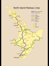
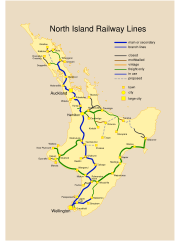
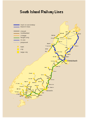
The New Zealand
railway network consists of four main lines, seven secondary lines and numerous short branch line
s in almost every region. It links all major urban centres except Nelson
, Taupo
and Queenstown. The network is owned and managed by the New Zealand Railways Corporation, trading as KiwiRail
. The network was constructed from 1863 onwards, mostly by government bodies, initially by the Provincial
and later by central government (usually the Public Works Department
). In 1993 New Zealand Rail Limited
was privatised (and later renamed Tranz Rail), with the New Zealand Railways Corporation retaining the land (due to Treaty of Waitangi
claims on land taken for railway construction). In 2003 the government renationalised the network. KiwiRail
operates all freight and most passenger services, including Tranz Metro
passenger trains in the Wellington region; Veolia operates MAXX suburban passenger trains in Auckland; the Taieri Gorge Railway
operates tourist passenger trains in Dunedin.
The latter two lines are sometimes referred to as the South Island Main Trunk Railway
, which constructed parts of the Midland, Nelson and some West Coast lines. After the company was dissolved in 1900 the railway lines and their construction were taken over by the government. Some lines were also built by companies for access such as to coal mines, and by local government bodies.
was built). Some significant proposals include:
A prominent example of a bush tramway was the Taupo Totara Timber Company's line between Putaruru and Mokai, and an example of a mineral tramway was the Dun Mountain Railway
.
, Wellington
, Christchurch
and Dunedin
, with smaller operations in Gisborne
, Napier
, New Plymouth
, Wanganui
, Nelson
and Invercargill
. Employing horse, steam or electric power, they operated in most cases until the 1950s when improved buses saw most of the tracks scrapped. Christchurch is the only city still with an urban tram operation, constructed from scratch in the late 1990s as a tourism venture. See Trams in New Zealand
.
in Dunedin, which employs paid staff.
New Zealand
New Zealand is an island country in the south-western Pacific Ocean comprising two main landmasses and numerous smaller islands. The country is situated some east of Australia across the Tasman Sea, and roughly south of the Pacific island nations of New Caledonia, Fiji, and Tonga...
railway network consists of four main lines, seven secondary lines and numerous short branch line
Branch line
A branch line is a secondary railway line which branches off a more important through route, usually a main line. A very short branch line may be called a spur line...
s in almost every region. It links all major urban centres except Nelson
Nelson, New Zealand
Nelson is a city on the eastern shores of Tasman Bay, and is the economic and cultural centre of the Nelson-Tasman region. Established in 1841, it is the second oldest settled city in New Zealand and the oldest in the South Island....
, Taupo
Taupo
Taupo is a town on the shore of Lake Taupo in the centre of the North Island of New Zealand. It is the seat of the Taupo District Council and lies in the southern Waikato Region....
and Queenstown. The network is owned and managed by the New Zealand Railways Corporation, trading as KiwiRail
KiwiRail
KiwiRail Holdings Limited is the rail operations subsidiary of the New Zealand Railways Corporation, which trades as KiwiRail. Headquartered in Wellington, New Zealand, KiwiRail is the largest rail transport operator in New Zealand. Since July 2010 John Spencer has been the Chairman...
. The network was constructed from 1863 onwards, mostly by government bodies, initially by the Provincial
Provinces of New Zealand
The Provinces of New Zealand existed from 1841 until 1876 as a form of sub-national government. They were replaced by counties, which were themselves replaced by districts.Following abolition, the provinces became known as provincial districts...
and later by central government (usually the Public Works Department
New Zealand Ministry of Works
The New Zealand Ministry of Works, formerly the Department of Public Works and sometimes referred to as the Public Works Department or PWD, was founded in 1876 and disestablished and privatised in 1988...
). In 1993 New Zealand Rail Limited
Tranz Rail
Tranz Rail, formally Tranz Rail Holdings Ltd , was the main rail operator in New Zealand from 1991 until it was purchased by Toll Holdings in 2003.- Formation :...
was privatised (and later renamed Tranz Rail), with the New Zealand Railways Corporation retaining the land (due to Treaty of Waitangi
Treaty of Waitangi
The Treaty of Waitangi is a treaty first signed on 6 February 1840 by representatives of the British Crown and various Māori chiefs from the North Island of New Zealand....
claims on land taken for railway construction). In 2003 the government renationalised the network. KiwiRail
KiwiRail
KiwiRail Holdings Limited is the rail operations subsidiary of the New Zealand Railways Corporation, which trades as KiwiRail. Headquartered in Wellington, New Zealand, KiwiRail is the largest rail transport operator in New Zealand. Since July 2010 John Spencer has been the Chairman...
operates all freight and most passenger services, including Tranz Metro
Tranz Metro
Tranz Metro, part of KiwiRail, is the operator of Metlink suburban trains owned by the Greater Wellington Regional Council in the Wellington Region of New Zealand....
passenger trains in the Wellington region; Veolia operates MAXX suburban passenger trains in Auckland; the Taieri Gorge Railway
Taieri Gorge Railway
The Taieri Gorge Railway is a railway line and tourist train operation based at Dunedin Railway Station in the South Island of New Zealand...
operates tourist passenger trains in Dunedin.
New Zealand national rail network
Main trunk lines
| Name | Route | Length | Usage |
|---|---|---|---|
| North Island Main Trunk Railway | Wellington Wellington Wellington is the capital city and third most populous urban area of New Zealand, although it is likely to have surpassed Christchurch due to the exodus following the Canterbury Earthquake. It is at the southwestern tip of the North Island, between Cook Strait and the Rimutaka Range... - Palmerston North Palmerston North Palmerston North is the main city of the Manawatu-Wanganui region of the North Island of New Zealand. It is an inland city with a population of and is the country's seventh largest city and eighth largest urban area. Palmerston North is located in the eastern Manawatu Plains near the north bank... - Taumarunui Taumarunui Taumarunui is a town in the King Country of the central North Island of New Zealand. It is on State Highway 4 and the North Island Main Trunk Railway.... - Hamilton Hamilton, New Zealand Hamilton is the centre of New Zealand's fourth largest urban area, and Hamilton City is the country's fourth largest territorial authority. Hamilton is in the Waikato Region of the North Island, approximately south of Auckland... - Auckland Auckland The Auckland metropolitan area , in the North Island of New Zealand, is the largest and most populous urban area in the country with residents, percent of the country's population. Auckland also has the largest Polynesian population of any city in the world... |
681 km (423 mi) | Freight & Passenger |
| East Coast Main Trunk Railway | Hamilton Hamilton, New Zealand Hamilton is the centre of New Zealand's fourth largest urban area, and Hamilton City is the country's fourth largest territorial authority. Hamilton is in the Waikato Region of the North Island, approximately south of Auckland... - Tauranga Tauranga Tauranga is the most populous city in the Bay of Plenty region, in the North Island of New Zealand.It was settled by Europeans in the early 19th century and was constituted as a city in 1963... - Kawerau |
Freight only | |
| Main North Line | Christchurch Christchurch Christchurch is the largest city in the South Island of New Zealand, and the country's second-largest urban area after Auckland. It lies one third of the way down the South Island's east coast, just north of Banks Peninsula which itself, since 2006, lies within the formal limits of... - Kaikoura Kaikoura Kaikoura is a town on the east coast of the South Island of New Zealand. It is located on State Highway 1 180 km north of Christchurch.Kaikoura became the first local authority to reach the Green Globe tourism certification standard.... - Blenheim Blenheim, New Zealand Blenheim is the most populous town in the region of Marlborough, in the north east of the South Island of New Zealand, and the seat of the regional council. It has a population of The area which surrounds the town is well known as a centre of New Zealand's wine industry... - Picton Picton, New Zealand Picton is a town in the Marlborough region of New Zealand. It is close to the head of Queen Charlotte Sound near the north-east corner of the South Island. The population was 2928 in the 2006 Census, a decrease of 72 from 2001... |
348 km (216 mi) | Freight & Passenger |
| Main South Line Main South Line The Main South Line, sometimes referred to as part of the South Island Main Trunk Railway, is a railroad line that runs north and south from Lyttelton in New Zealand through Christchurch and along the east coast of the South Island to Invercargill via Dunedin... |
Lyttelton Lyttelton, New Zealand Lyttelton is a port town on the north shore of Lyttelton Harbour close to Banks Peninsula, a suburb of Christchurch on the eastern coast of the South Island of New Zealand.... - Christchurch Christchurch Christchurch is the largest city in the South Island of New Zealand, and the country's second-largest urban area after Auckland. It lies one third of the way down the South Island's east coast, just north of Banks Peninsula which itself, since 2006, lies within the formal limits of... - Timaru Timaru TimaruUrban AreaPopulation:27,200Extent:Former Timaru City CouncilTerritorial AuthorityName:Timaru District CouncilPopulation:42,867 Land area:2,736.54 km² Mayor:Janie AnnearWebsite:... - Dunedin Dunedin Dunedin is the second-largest city in the South Island of New Zealand, and the principal city of the Otago Region. It is considered to be one of the four main urban centres of New Zealand for historic, cultural, and geographic reasons. Dunedin was the largest city by territorial land area until... - Invercargill Invercargill Invercargill is the southernmost and westernmost city in New Zealand, and one of the southernmost cities in the world. It is the commercial centre of the Southland region. It lies in the heart of the wide expanse of the Southland Plains on the Oreti or New River some 18 km north of Bluff,... |
601 km (373 mi) | Freight & Passenger (Christchurch - Rolleston) Freight only (Lyttleton - Christchurch, Rolleston - Invercargill) |
The latter two lines are sometimes referred to as the South Island Main Trunk Railway
South Island Main Trunk Railway
The Main North Line between Picton and Christchurch and the Main South Line between Lyttelton and Invercargill, running down the east coast of the South Island of New Zealand, are sometimes together referred to as the South Island Main Trunk Railway...
Secondary main lines
| Name | Route | Length | Usage |
|---|---|---|---|
| Marton - New Plymouth Line | Marton Marton, New Zealand Marton is the hub of the Rangitikei district of the Manawatu-Wanganui region of New Zealand's North Island. It is situated 35 kilometres southeast of Wanganui and 40 kilometres northwest of Palmerston North. The population was 4752 .-History:... - Wanganui Wanganui Whanganui , also spelled Wanganui, is an urban area and district on the west coast of the North Island of New Zealand. It is part of the Manawatu-Wanganui region.... - Hawera Hawera Hawera is the second-largest town in the Taranaki region of New Zealand's North Island, with a population of . It is near the coast of the South Taranaki Bight, 75 kilometres south of New Plymouth on State Highway 3 and 20 minutes' drive from Mount Taranaki/Egmont.It is also on State Highway 45,... - New Plymouth New Plymouth New Plymouth is the major city of the Taranaki Region on the west coast of the North Island of New Zealand. It is named after Plymouth, Devon, England, from where the first English settlers migrated.... |
Freight only | |
| Midland Line Midland Line, New Zealand The Midland line is a 212 km section of railway between Rolleston and Greymouth in the South Island of New Zealand. The line features five major bridges, five viaducts and 17 tunnels, the longest of which is the Otira tunnel.-Freight services:... |
Rolleston Rolleston, New Zealand Rolleston is a town in the Selwyn District of Canterbury, New Zealand.It is located next to State Highway 1, 22 km south-west of Christchurch on the Canterbury Plains in the South Island of New Zealand. The town uses the slogan "The Town of the Future"... - Springfield Springfield, New Zealand Springfield is a small town in the Selwyn District of Canterbury, in the South Island, of New Zealand. In 2001 it had a population of 219. At the foot of the Southern Alps, west of Christchurch, it is the most westerly town of the central Canterbury Plains... - Arthurs Pass - Greymouth Greymouth Greymouth is the largest town in the West Coast region in the South Island of New Zealand, and the seat of the Grey District Council. The population of the whole Grey District is , which accounts for % of the West Coast's inhabitants... |
212 km (132 mi) | Freight & Passenger |
| North Auckland Line | Auckland Auckland The Auckland metropolitan area , in the North Island of New Zealand, is the largest and most populous urban area in the country with residents, percent of the country's population. Auckland also has the largest Polynesian population of any city in the world... - Waitakere Waitakere Waitakere City was the name of a city which existed from 1989 until 2010 in the Auckland region. It was New Zealand's fifth largest city, with an annual growth of about 2%... - Helensville Helensville, New Zealand Helensville is a town in the North Island of New Zealand. It is sited 40 kilometres northwest of Auckland, close to the southern extremity of the Kaipara Harbour. State Highway 16 passes through the town, connecting it to Waimauku 16 km to the south, and Kaukapakapa about 12 km to the... - Wellsford Wellsford Wellsford is a town in the northern North Island of New Zealand. The town is the northernmost major settlement in the Auckland Region, and is 114 kilometres northwest of Auckland City..... - Whangarei Whangarei Whangarei, pronounced , is the northernmost city in New Zealand and the regional capital of Northland Region. Although commonly classified as a city, it is officially part of the Whangarei District, administered by the Whangarei District Council a local body created in 1989 to administer both the... - Otiria Otiria Otiria is a rural locality in the Northland Region of New Zealand's North Island. It neighbours Moerewa to the east, with the nearest major town, Kawakawa a few kilometres further eastwards. Other nearby localities include Pokapu to the south, Orauta to the west, and Hupara to the north.-... |
281 km (175 mi) | Freight and Passenger south of Waitakere Train Station Waitakere Train Station Waitakere Railway Station is located in the Waitakere suburb/village at the end of the Western Line of the Auckland Suburban Network in New Zealand and is currently the terminus for most Western Line services.... Freight only Waitakere to Otiria |
| Palmerston North - Gisborne Line Palmerston North - Gisborne Line The Palmerston North – Gisborne Line is a secondary main line railway in the North Island of New Zealand. It branches from the North Island Main Trunk Railway in Palmerston North and runs east through the Manawatu Gorge to Woodville, where it meets the Wairarapa Line, and then proceeds to... |
Palmerston North Palmerston North Palmerston North is the main city of the Manawatu-Wanganui region of the North Island of New Zealand. It is an inland city with a population of and is the country's seventh largest city and eighth largest urban area. Palmerston North is located in the eastern Manawatu Plains near the north bank... - Woodville Woodville, New Zealand Woodville is a small town in the southern North Island of New Zealand, 75 km north of Masterton and 25 km east of Palmerston North. In the 2006 census 1,398 people are usually resident in Woodville, a decrease of 81 people, or 5.5%, since the 2001 Census.-Early History and Local... - Waipukurau Waipukurau Waipukurau , also known as Ypuk, is the largest town in the Central Hawke's Bay District on the east coast of the North Island of New Zealand. It is located 50 kilometres southwest of Hastings on the banks of the Tukituki River.... - Hastings Hastings, New Zealand The city of Hastings is a major urban settlement in the Hawke's Bay region of the North Island of New Zealand, and it is the largest settlement by population in Hawke's Bay. Hastings city is the administrative centre of the Hastings District... - Napier Napier, New Zealand Napier is a New Zealand city with a seaport, located in Hawke's Bay on the eastern coast of the North Island. The population of Napier is about About 18 kilometres south of Napier is the inland city of Hastings. These two neighboring cities are often called "The Twin Cities" or "The Bay Cities"... - Gisborne Gisborne, New Zealand -Economy:The harbour was host to many ships in the past and had developed as a river port to provide a more secure location for shipping compared with the open roadstead of Poverty Bay which can be exposed to southerly swells. A meat works was sited beside the harbour and meat and wool was shipped... |
Freight only | |
| Stillwater - Westport Line Stillwater - Westport Line The Stillwater Ngakawau Line , formerly the Stillwater - Westport Line and the Ngakawau Branch, is a secondary main line, part of New Zealand's national rail network. It runs between Stillwater and Ngakawau via Westport on the West Coast of the South Island... |
Stillwater - Reefton - Westport Westport, New Zealand -Economy:Economic activity is based around fishing, coal mining and dairy farming. Historically, gold mining was a major industry, and coal mining was much more extensive than today . However, the region still is home to New Zealand's largest opencast mining operation in Stockton... - Ngakawau |
Freight only | |
| Stratford - Okahukura Line | Stratford Stratford, New Zealand Stratford is the only town in the central Taranaki district of Stratford District, New Zealand. It lies beneath the eastern slopes of Mount Taranaki/Egmont, approximately half-way between New Plymouth and Hawera, near the geographic centre of the Taranaki region. The town has a population of... - Whangamomona Whangamomona Whangamomona is a small township in the Stratford District and Manawatu-Wanganui Region in New Zealand. It lies on State Highway 43, the Lost World Highway north-east of Stratford and south-west of Ohura. By rail it is from Stratford on the Stratford-Okahukura railway line.- History :The first... - Okahukura |
144 km (89 mi) | Mothballed |
| Wairarapa Line Wairarapa Line The Wairarapa Line is a secondary railway line in the south-east of the North Island of New Zealand, connecting the capital city of Wellington with the Wairarapa region. The line ends at Woodville, where it joins the Palmerston North - Gisborne Line... |
Wellington - Upper Hutt Upper Hutt Upper Hutt is a satellite city of Wellington. It is New Zealand's smallest city by population, the second largest by land area. It is in Greater Wellington.-Geography:Upper Hutt is 30 km north-east of Wellington... - Masterton Masterton Masterton is a large town and local government district in the Wellington Region of New Zealand. It is the largest town in the Wairarapa, a region separated from Wellington by the Rimutaka ranges... - Woodville Woodville, New Zealand Woodville is a small town in the southern North Island of New Zealand, 75 km north of Masterton and 25 km east of Palmerston North. In the 2006 census 1,398 people are usually resident in Woodville, a decrease of 81 people, or 5.5%, since the 2001 Census.-Early History and Local... |
176 km (109 mi) | Freight & Passenger Wellington to Masterton Freight only Masterton to Woodville |
Northland
| Name | Route | Usage |
|---|---|---|
| Dargaville Branch Dargaville Branch The Dargaville Branch is a branch line railway that leaves the North Auckland Line not far south of Whangarei and runs westward to Dargaville. Construction of this relatively short line took approximately two decades, and when it was completed, it linked the now closed Donnelly's Crossing Section... |
Waiotira - Dargaville | Freight only |
| Donnellys Crossing Section Donnelly's Crossing Section The Donnellys Crossing Section , also known as the Kaihu Valley Railway, was a railway line in Northland, New Zealand. Initially an isolated line, it became a branch line when the Dargaville Branch was opened and connected it with the North Auckland Line and the rest of the national rail network... |
Dargaville - Kaihu - Donnellys Crossing | Closed 1959 |
| Kumeu-Riverhead Section Kumeu-Riverhead Section The Kumeu-Riverhead section was a short-lived railway line north-west of Auckland, New Zealand. It was built as part of the Kaipara-Riverhead Railway, which was isolated from the national railway network until 1881, just before closure of this section.... |
Kumeu - Riverhead | Closed 1885 |
| Okaihau Branch Okaihau Branch The Okaihau Branch, sometimes known as the Kaikohe Branch and rarely the Rangiahua Branch, was a branch line railway that joined the North Auckland Line of the national rail network of New Zealand at Otiria. It was the most northerly line in New Zealand and was intended to run all the way to Kaitaia... |
Otiria - Kaikohe - Okaihau | Closed 1987 |
| Onerahi Branch | Whangarei - Onerahi | Closed 1933 |
| Opua Branch Opua Branch The Opua Branch or Otiria-Opua Industrial Line, partially still operational as the Bay of Islands Vintage Railway, is a former section of the North Auckland Line in the Northland Region of New Zealand, between Otiria and the Bay of Islands township of Opua. The first section was constructed as a... |
Otiria - Kawakawa - Opua | Closed 1985 Kawakawa - Opua section operated by Bay of Islands Vintage Railway Bay of Islands Vintage Railway The Bay of Islands Vintage Railway Trust is a heritage railway in Kawakawa, in Northland in New Zealand. The railway operates on part of the former Opua Branch railway.-History:... |
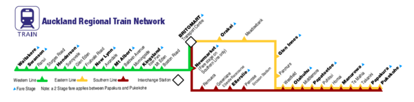
Auckland
| Name | Route | Usage |
|---|---|---|
| Auckland - Newmarket Line | Auckland CBD - Newmarket | Freight & Passenger |
| Southdown Branch | Westfield Junction - Southdown Freight Centre | Freight only |
| Mission Bush Branch Waiuku and Mission Bush Branches The Waiuku and Mission Bush Branches are two branches on the New Zealand railway network which are closely linked. The Mission Bush Branch connects the North Island Main Trunk railway to the Mission Bush Steel Mill.-History:... |
Paerata - Mission Bush | Freight only |
| Onehunga Branch | Penrose - Onehunga | Passenger |
| Waiuku Branch Waiuku and Mission Bush Branches The Waiuku and Mission Bush Branches are two branches on the New Zealand railway network which are closely linked. The Mission Bush Branch connects the North Island Main Trunk railway to the Mission Bush Steel Mill.-History:... |
Glenbrook - Waiuku | Closed 1967 Now Glenbrook Vintage Railway Glenbrook Vintage Railway The Glenbrook Vintage Railway is a steam railway in Glenbrook, New Zealand. One of New Zealand's premiere rail heritage sites, it is not a museum as such, but rather a fully self-supporting, operating steam railway, built almost entirely by volunteer labour... |
Suburban rail lines
| Name | Route |
|---|---|
| Eastern Line Eastern Line, Auckland The Eastern Line in Auckland, New Zealand is the name given to Auckland suburban part of the North Island Main Trunk. Suburban services are operated by Veolia under the MAXX brand... |
Britomart Transport Centre Britomart Transport Centre Britomart Transport Centre is the CBD public transport hub of Auckland, New Zealand, and the northern terminus of the North Island Main Trunk line. It combines a bus interchange with a railway station in a former Edwardian post office, extended with expansive post-modernist architectural elements... - Sylvia Park - Pukekohe Pukekohe Train Station Pukekohe Railway Station is the southern terminus of the Eastern and Southern Lines of the Auckland railway network. It has an island platform between the main lines and an original wooden station building complete with signal panel.... North Island Main Trunk Line |
| Southern Line Southern Line, Auckland The Southern Line in Auckland, New Zealand is the name given to suburban train services that operate between Britomart and Pukekohe via Newmarket.-Routing:... |
Britomart Transport Centre - Newmarket Newmarket Train Station, Auckland Newmarket Train Station is located in the Auckland, New Zealand suburb of Newmarket, on the Southern and Western Lines of the Auckland railway network. Serving the busy commercial centre of Newmarket, the station is the second-busiest train station in Auckland, after Britomart... - Pukekohe Auckland - Newmarket Line, North Auckland Line, North Island Main Trunk Line |
| Western Line Western Line, Auckland The Western Line in Auckland, New Zealand is the name given to suburban services that operate between Britomart and Waitakere via Newmarket.-Routing:... |
Britomart Transport Centre - Newmarket - Waitakere Waitakere Train Station Waitakere Railway Station is located in the Waitakere suburb/village at the end of the Western Line of the Auckland Suburban Network in New Zealand and is currently the terminus for most Western Line services.... Auckland - Newmarket Line, North Auckland Line |
| Onehunga Line | Britomart Transport Centre - Newmarket - Penrose - Onehunga Auckland - Newmarket Line, North Auckland Line, Onehunga Branch Line |
Waikato / Coromandel
| Name | Route | Usage |
|---|---|---|
| East Coast Main Trunk | Frankton Frankton -In New Zealand:*Frankton, Waikato, in the North Island*Frankton, Otago, in the South Island-Other Uses:*Operation Frankton a commando raid on shipping in the German occupied French port of Bordeaux during the Second World War... - Morrinsville Morrinsville Morrinsville is a town in the Waikato region of New Zealand's North Island. The land for the town and surrounding farmland was purchased from Wirimu Tamehana,the king maker prior to the NZ land wars of the 1860s. The land then was very swampy... - Paeroa Paeroa Paeroa is a small town in New Zealand, in the northern Waikato region of the Thames Valley. Located at the foot of the Coromandel Peninsula, it is close to the junction of the Waihou and Ohinemuri Rivers, 20 kilometres from the coast at the Firth of Thames... - Waihi Waihi Waihi is a town in Hauraki District in the North Island of New Zealand, especially notable for its history as a gold mine town. It had a population of 4,503 at the 2006 census.... - Tauranga Tauranga Tauranga is the most populous city in the Bay of Plenty region, in the North Island of New Zealand.It was settled by Europeans in the early 19th century and was constituted as a city in 1963... - Taneatua Taneatua Taneatua is a small town in the Bay of Plenty region of New Zealand's North Island. It is officially defined as a "populated area less than a town". The 2001 New Zealand Census of Population and Dwellings found its population to be 750, a 14.7% decline since the previous census in 1996... |
Closed Paeroa to Apata, September, 1978. Waikino to Waihi reopened 8 November 1980 by Goldfields Railway Goldfields Railway The Goldfields Railway is a heritage railway that operates between Waihi and Waikino in the Bay of Plenty region of New Zealand's North Island. It operates over a section of track that was part of the East Coast Main Trunk Railway until the Kaimai Tunnel deviation made it redundant in 1978... . Hawken's Junction to Taneatua became Taneatua Branch. |
| Cambridge Branch | Ruakura Ruakura Ruakura is a semi-rural suburb of Hamilton City, in the Waikato region of New Zealand. The University of Waikato is nearby. The area lies to the east of urban Hamilton and to the west of State Highway 1B .The Waikato region is a major contributor to New Zealand's agricultural-based economy, and... - Hautapu - Cambridge Cambridge, New Zealand Cambridge is a town in the Waikato region of the North Island of New Zealand. Situated 24 kilometres southeast of Hamilton, on the banks of the Waikato River, Cambridge is known as "The Town of Trees & Champions".In the 1840s Cambridge had a Maori population but in the 1850's missionaries and... |
Freight only. Closed Hautapu - Cambridge 1999 |
| Glen Afton Branch | Closed, partially remains as the Bush Tramway Club's Pukemiro Line. Remainder became Rotowaro Branch | |
| Kimihia Branch | Freight only | |
| Rotowaro Branch | Freight only | |
| Thames Branch/Waitoa Industrial Line Thames Branch The Thames Branch railway line connected Thames, New Zealand, with Hamilton and was originally part of the East Coast Main Trunk Railway. Part of the line between Morrinsville and Waitoa remains open and is in use as the Waitoa Industrial Line, connecting to the Fonterra Dairy Factory at... |
Morrinsville Morrinsville Morrinsville is a town in the Waikato region of New Zealand's North Island. The land for the town and surrounding farmland was purchased from Wirimu Tamehana,the king maker prior to the NZ land wars of the 1860s. The land then was very swampy... - Waitoa Waitoa Waitoa is a settlement in New Zealand. The population in the 2006 census was 318, a decrease of 42 people since 2001.A Fonterra dairy factory is a prominent blue building in the middle of the town.... - Paeroa Paeroa Paeroa is a small town in New Zealand, in the northern Waikato region of the Thames Valley. Located at the foot of the Coromandel Peninsula, it is close to the junction of the Waihou and Ohinemuri Rivers, 20 kilometres from the coast at the Firth of Thames... - Thames Thames, New Zealand Thames is a town at the southwestern end of the Coromandel Peninsula in New Zealand's North Island. It is located on the Firth of Thames close to the mouth of the Waihou River. The town is the seat of the Thames-Coromandel District Council.... |
Morrinsville to Paeroa was a section of East Coast Main Trunk, 1928 to 1978. Freight only. Closed Waitoa - Thames 1991. Mothballed section between Morrinsville and Waitoa reopened 2004 as Waitoa Industrial Line. |
| Wilton Colleries Line | Closed, 1959 |
Bay of Plenty
| Name | Route | Usage |
|---|---|---|
| Kinleith Branch Kinleith Branch The Kinleith Branch railway line is located in the Waikato region of New Zealand. The line was constructed by the Thames Valley and Rotorua Railway Company, Taupo Totara Timber Company and rebuilt by the Public Works Department primarily to serve the Kinleith Mill in 1952... |
Morrinsville - Kinleith Mill Kinleith Mill The Kinleith Mill is a Carter Holt Harvey pulp and paper plant located at Kinleith, Tokoroa, New Zealand. The mill is the largest of four pulp and paper mills operated by Carter Holt Harvey... |
Freight only |
| Mount Maunganui Branch | Freight only | |
| Murupara Branch | Freight only | |
| Rotorua Branch Rotorua Branch The Rotorua Branch is a railway line from Putaruru to Rotorua, in the Waikato and Bay of Plenty regions of the North Island of New Zealand. Construction of the line was commenced by the Thames Valley and Rotorua Railway Company and finished by the Public Works Department... |
Putaruru Putaruru Putaruru is a small town in the Waikato region of New Zealand's North Island. It is on the Oraka River 65 kilometres south-east of Hamilton.... - Rotorua Rotorua Rotorua is a city on the southern shores of the lake of the same name, in the Bay of Plenty region of the North Island of New Zealand. The city is the seat of the Rotorua District, a territorial authority encompassing the city and several other nearby towns... /Koutu |
Mothballed |
| Taneatua Branch | Mothballed | |
| Whakatane Industrial Line | Awakeri - Whakatane mill | Closed |
Gisborne - Hawke's Bay
| Name | Route | Usage |
|---|---|---|
| Napier Port Branch/Ahuriri Branch Ahuriri Branch The Ahuriri Branch, now known as the Napier Port Branch, is a 2km railway branch line off the secondary Palmerston North - Gisborne Line, in Napier, New Zealand. The branch serves the Port of Napier, and terminates in a stockyard.... |
Freight only | |
| Moutohora Branch Moutohora Branch The Moutohora Branch was a branch line railway that formed part of New Zealand's national rail network in Poverty Bay in the North island of New Zealand. The branch ran for 78 km approximately North-West from Gisborne into the rugged and steep Raukumara Range to the terminus at Moutohora... |
Gisborne Gisborne, New Zealand -Economy:The harbour was host to many ships in the past and had developed as a river port to provide a more secure location for shipping compared with the open roadstead of Poverty Bay which can be exposed to southerly swells. A meat works was sited beside the harbour and meat and wool was shipped... - Makaraka Makaraka, New Zealand Makaraka is an outer suburb of Gisborne, in New Zealand's North Island. It is located to the west of the city, and is the home of Gisborne's horse-racing circuit, Makaraka Racecourse.... - Moutohora |
Freight only. Closed Makaraka - Moutohora 1959 |
| Ngatapa Branch Ngatapa Branch The Ngatapa Branch was a secondary branch line railway that for a short time formed part of the national rail network in Poverty Bay in the North Island of New Zealand... |
Gisborne - Ngatapa | Closed 1931 |
Central North Island
| Name | Route | Usage |
|---|---|---|
| Raetihi Branch | Ohakune Ohakune Ohakune is a town in the North Island of New Zealand. It is located at the southern end of the Tongariro National Park, close to the southwestern slopes of the active volcano Mount Ruapehu. Part of the Manawatu-Wanganui region, the town is 70 kilometres northeast of Wanganui, and 25 kilometres west... - Raetihi Raetihi Raetihi is a town in the central North Island of New Zealand. It is located at the junction of State Highways 4 and 49, 11 kilometres west of Ohakune. The 2006 New Zealand Census of Population and Dwellings recorded its population as 1,035. This constitutes a decrease of 3.4% or 36 people since... |
Closed 1968 |
Taranaki
| Name | Route | Usage |
|---|---|---|
| Castlecliff Branch | Wanganui Wanganui Whanganui , also spelled Wanganui, is an urban area and district on the west coast of the North Island of New Zealand. It is part of the Manawatu-Wanganui region.... - Castlecliff |
Freight only. Mothballed 2006. Reopened 2010. |
| Opunake Brance/Kapuni Branch | Eltham Eltham, New Zealand thumb|left|The town center of ElthamEltham is a small inland town in South Taranaki, New Zealand, located 50 km south of the city of New Plymouth and southeast of the volcanic cone of Mount Taranaki/Egmont. Stratford is 11 km north, Kaponga 13 km west, and Hawera 19 km south.... - Kapuni Kapuni Kapuni is a small hydrocarbons field and drilling site in the North Island of New Zealand. It is located within a dairy farming area in Taranaki, south of New Plymouth.... - Opunake Opunake Opunake is a small town on the southwest coast of Taranaki in New Zealand's North Island. It is located 45 kilometres southwest of New Plymouth. Rahotu is 16 km to the northwest. Manaia is 29 km to the southeast. State Highway 45 passes through the town.The population was 1368 in the... |
Freight only. Closed Kapuni - Opunake |
| Mount Egmont Branch | Closed | |
| Waitara Branch | Lepperton Lepperton Lepperton is a small village in north Taranaki, New Zealand. It is approximately 6 km inland from Waitara township, 5 km west of the Waitara River, and 1 km east of State Highway 3A, which connects Inglewood to Waitara.... - Waitara Waitara, New Zealand Waitara is the name of a town and a river in the northern part of the Taranaki Region of the North Island of New Zealand. Waitara is located just off State Highway 3, 15 km northeast of New Plymouth.... |
Closed 1999 Now operated by the Waitara Rail Preservation Society |
| Wanganui Branch | Aramoho - Wanganui Wanganui Whanganui , also spelled Wanganui, is an urban area and district on the west coast of the North Island of New Zealand. It is part of the Manawatu-Wanganui region.... |
Freight only |
Manawatu
| Name | Route | Usage |
|---|---|---|
| Foxton Branch Foxton Branch The Foxton Branch was a railway line in New Zealand. It began life as a tramway, evolved into a railway by 1876, and operated until 1959. At Himatangi there was a junction with the Sanson Tramway, a line operated by the Manawatu County Council that was never upgraded to the status of a... |
Longburn Longburn Longburn is a rural settlement just outside of Palmerston North in the Manawatu-Wanganui area of New Zealand. Made up of large dairy processing plants Longburn is often mistaken to be a small township and not seen as a large satellite town of Palmerston North... - Foxton Foxton, New Zealand Foxton is a town in the Manawatu-Wanganui region of New Zealand. The 2006 census population was 2715.It is located on the lower west coast of the North Island, in the Horowhenua district, 30 kilometres southwest of Palmerston North and 15 kilometres north of Levin. The town is located close to the... |
Closed 1959 |
| Taonui Branch | Taonui - near Colyton | Closed 1895 |
Wairarapa
| Name | Route | Usage |
|---|---|---|
| Greytown Branch Greytown Branch The Greytown Branch was a five-kilometre branch line railway off the Wairarapa Line at Woodside in the Wairarapa district of New Zealand's North Island. It followed an almost straight course over flat terrain... |
Woodside Junction - Greytown Greytown Railway Station Greytown railway station was the terminus of the Greytown Branch railway, which connected the Wairarapa town of Greytown in New Zealand’s North Island to Woodside on the Wairarapa Line.- History :... |
Closed 1953 |
Wellington
| Name | Route | Usage |
|---|---|---|
| Gracefield Branch | Woburn Woburn, New Zealand Woburn is a suburb of Lower Hutt, Wellington situated at the bottom of the North Island of New Zealand.Henry Petre farmed the area in the 1840s and named the area after the Duke of Bedford's estate, Woburn Abbey. Petre's farm was later taken over by Daniel and Harriet Riddiford, whose descendants... - Hutt Workshops Hutt Workshops The Hutt Railway Workshops is a major railway engineering facility in the Lower Hutt suburb of Gracefield in the Wellington region of New Zealand’s North Island... - Gracefield Gracefield, New Zealand Gracefield is an industrial suburb of Lower Hutt City, located at the bottom of the North Island of New Zealand.Up until the 1980s, Gracefield and neighbouring Petone were home to woollen mills, railway workshops, car assembly and meat processing plants... |
Freight only. Hutt Workshops - Gracefield mothballed 2002 |
| Johnsonville Branch | Wellington Wellington Railway Station Wellington Railway Station is the southern terminus of New Zealand's North Island Main Trunk railway, Wairarapa Line and Johnsonville Line. In terms of number of services and in passenger numbers, it is New Zealand's busiest railway station.-Development:... - Johnsonville Johnsonville Railway Station Johnsonville railway station is the terminus of the Johnsonville Line, one of eight stations on the commuter branch railway north of Wellington in New Zealand’s North Island... |
Passenger only. Former North Island Main Trunk Line |
| Melling Branch Melling Branch The Melling Branch is a railway branch line in the Hutt Valley, north of Wellington, New Zealand. It is part of the national rail network and formerly part of the Wairarapa Line... |
Petone Petone Railway Station Petone railway station is a dual platform, suburban railway station serving Petone, a suburb of Hutt City in the Wellington region of New Zealand’s North Island. Facilities at this station include a bus terminal, carpark, ticket office, and cycle storage... - Melling Melling, New Zealand Melling is a suburb of Lower Hutt, to the north of Wellington in the North Island of New Zealand. It is on the west bank of the Hutt River, on State Highway 2, the Wellington-Hutt main road, and directly across the river from the centre of Lower Hutt... |
Passenger only. Former Wairarapa Line |
| Te Aro Branch Te Aro Extension The Te Aro Extension, also known as the Te Aro Branch, was a short branch line railway in Wellington, New Zealand continuing the Wairarapa Line southwards... |
Lambton - Te Aro Te Aro Te Aro is an inner-city suburb of Wellington, New Zealand, 1 km from the centre. It comprises the southern part of the central business district including the majority of the city's entertainment district and covers the mostly flat area of city between The Terrace and Cambridge Terrace at the base... |
Closed 1917 |
Suburban rail lines
| Name | Route |
|---|---|
| Johnsonville Line | Wellington - Johnsonville Johnsonville Branch |
| Kapiti Line | Wellington - Waikanae North Island Main Trunk Line |
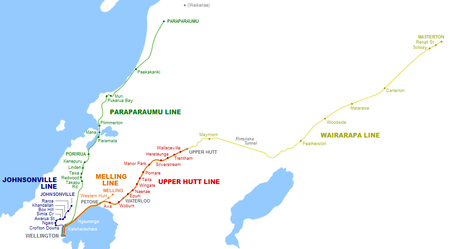
| Hutt Valley Line | Wellington - Upper Hutt Upper Hutt Railway Station Upper Hutt railway station is a two-platform urban railway station serving the city of Upper Hutt in the Wellington region of New Zealand’s North Island. The station lies on the Wairarapa Line, and is on Station Crescent, off Fergusson Drive... Wairarapa Line |
| Melling Line | Wellington - Melling Wairarapa Line, Melling Branch |
| Wairarapa Connection | Wellington - Masterton Masterton Railway Station Masterton railway station is a single-platform, urban railway station serving the town of Masterton in the Wairarapa district of New Zealand. The station lies on the Wairarapa Line, and is located at the end of Perry Street. It is one hour, thirty seven minutes journey time to Wellington. Trains... Wairarapa Line |
Nelson
| Name | Route | Usage |
|---|---|---|
| Nelson Section Nelson Section The Nelson Section was an isolated, gauge, government-owned railway line between Nelson and Glenhope in the Tasman district of New Zealand's South Island. It operated for years between 1876 and 1955... |
Nelson Nelson, New Zealand Nelson is a city on the eastern shores of Tasman Bay, and is the economic and cultural centre of the Nelson-Tasman region. Established in 1841, it is the second oldest settled city in New Zealand and the oldest in the South Island.... - Kawatiri Kawatiri Railway Station Kawatiri railway station was a rural railway station that served the small settlement of Kawatiri in the Tasman District of New Zealand’s South Island. Kawatiri is located on State Highway 6 at the junction with State Highway 63. It was one of 25 stations on the Nelson Section, and marked the... |
Isolated from South Island network. Closed 1955 |
Westland
| Name | Route | Usage |
|---|---|---|
| Blackball Branch Blackball Branch The Blackball Branch was a branch line railway of New Zealand's national rail network on the West Coast of the South Island and worked from the 1900s to 1966. It included the Roa Branch, also known as the Roa Incline... |
Closed 1966 | |
| Cape Foulwind Railway Cape Foulwind Railway The Cape Foulwind Railway was a branch railway line west of Westport to Cape Foulwind. In 1886 the Westport Harbour Board built the line to their quarry to transport rocks to their breakwaters in the Buller River. In 1888 it was linked to Westport by a road-rail bridge over the Buller River. About... |
Westport, New Zealand Westport, New Zealand -Economy:Economic activity is based around fishing, coal mining and dairy farming. Historically, gold mining was a major industry, and coal mining was much more extensive than today . However, the region still is home to New Zealand's largest opencast mining operation in Stockton... - Cape Foulwind Cape Foulwind Cape Foulwind is a prominent headland on the West Coast of New Zealand's South Island, overlooking the Tasman Sea. It is located ten kilometres west of the town of Westport... |
Closed 1930 |
| Conns Creek Branch Conns Creek Branch The Conns Creek Branch was a short branch line railway in the West Coast region of New Zealand's South Island. It diverged from the Seddonville Branch in Waimangaroa and followed the Waimangaroa River to its terminus at the foot of the Denniston Incline... |
Waimangaroa Waimangaroa Waimangaroa is a small town located on the West Coast of New Zealand.The township lies on the south-west bank of the Waimangaroa River, at the western foot of the Mt William Range. It is 17 kilometres to the north east of Westport and 13 km south-east of Granity. The abandoned coaltown of... - Denniston, New Zealand |
Closed 1967 |
| Hokitika Branch/Ross Branch | Greymouth Greymouth Greymouth is the largest town in the West Coast region in the South Island of New Zealand, and the seat of the Grey District Council. The population of the whole Grey District is , which accounts for % of the West Coast's inhabitants... - Hokitika - Ross Ross, New Zealand Ross is a small town located on the West Coast of New Zealand's South Island.It lies 27 kilometres south-west of Hokitika and 46 kilometres north-east of Harihari... |
Freight only. Closed Hokitika - Ross 1980 |
| Ngakawau Branch/Seddonville Branch Seddonville Branch The Seddonville Branch, now truncated and operating as the Ngakawau Branch, is a branch line railway in the West Coast region of New Zealand's South Island. Construction of the line began in 1874 and it reached its final terminus at the Mokihinui Mine just beyond Seddonville in 1895... |
Westport - Ngakawau - Seddonville Seddonville Seddonville is a lightly populated locality on the West Coast of New Zealand's South Island. It is most famous for the historical role it played in New Zealand's coal mining industry.-Geography:... - Mokihinui Mine |
Freight only. Closed Seddonville - Mokihinui Mine 1974, Ngakawau - Seddonville 1981 |
| Rapahoe Branch | Greymouth - Rapahoe | Freight only |
| Rewanui Branch | Greymouth - Rewanui | Closed 1985 |
Canterbury
| Name | Route | Usage |
|---|---|---|
| Eyreton Branch | Kaiapoi Kaiapoi Kaiapoi is a town in the Canterbury region of the South Island of New Zealand, located close to the mouth of the Waimakariri River, and approximately 17 kilometres north of Christchurch.... - Wetheral - Horrelville - Bennetts Junction |
Closed Horrelville - Bennetts Junction 1931, Wetheral - Horrelville 1954, Kaiapoi - Wetheral 1965 |
| Fairlie Branch Fairlie Branch The Fairlie Branch was a branch line railway in southern Canterbury which formed part of New Zealand's national railway network. Construction began in 1874, and at its farthest extent, it terminated just beyond Fairlie in Eversley... |
Washdyke Washdyke Washdyke is an industrial suburb in the north of Timaru, in south Canterbury, New Zealand. State Highway 1 passes through Washdyke on the way north out of the city... - Eversley |
Closed 1968 Pleasant Point section operatred by Pleasant Point Museum and Railway Pleasant Point Museum and Railway thumb|right|Pleasant Point Museum and Railway YardThe Pleasant Point Museum and Railway is a narrow gauge heritage railway located in the small country town of Pleasant Point in southern Canterbury, New Zealand, inland from Timaru. Its main terminal is located at Pleasant Point station, which was... Proposed Fairlie Rail Trail |
| Ferrymead Branch Ferrymead Railway The Ferrymead Railway is a New Zealand heritage railway built upon the formation of New Zealand's first public railway, the line from Ferrymead to Christchurch, which opened in 1863. On the opening of the line to Lyttelton on 9 December 1867, the Ferrymead Railway became the Ferrymead Branch and... |
Christchurch Christchurch Christchurch is the largest city in the South Island of New Zealand, and the country's second-largest urban area after Auckland. It lies one third of the way down the South Island's east coast, just north of Banks Peninsula which itself, since 2006, lies within the formal limits of... - Ferrymead Ferrymead -Geography:Ferrymead is located on the Avon Heathcote Estuary, close to the point where the Heathcote River drains into the estuary, and three km west of the eventual outflow into Pegasus Bay. To the north lie the oxidation ponds from Christchurch's main sewage treatment works, which are within a... |
Closed 1868 Now Ferrymead Railway Ferrymead Railway The Ferrymead Railway is a New Zealand heritage railway built upon the formation of New Zealand's first public railway, the line from Ferrymead to Christchurch, which opened in 1863. On the opening of the line to Lyttelton on 9 December 1867, the Ferrymead Railway became the Ferrymead Branch and... |
| Hornby Industrial Line/Southbridge Branch | Hornby Hornby, New Zealand Hornby is a major residential and retail suburb at the western edge of Christchurch, New Zealand.-Naming and history:Hornby was apparently named by Frederick William Delamain, who came to Christchurch from England in 1852. The name reportedly refers to Hornby-with-Farleton in Lancashire... - Prebbleton Prebbleton Prebbleton is a small town in the Canterbury region of New Zealand. It is 11 km southwest of the centre of Christchurch and about 2 km south of the outlying industrial suburb of Hornby.... - Lincoln Lincoln, New Zealand Lincoln is a town in the Selwyn District of Canterbury, New Zealand. The town has a population of 2,727.-Location:It is located on the Canterbury Plains to the west of Banks Peninsula, 22 kilometres south of Christchurch.-History:... - Southbridge Southbridge, New Zealand Southbridge is a small town with a population of 720 and approximately 260 houses, on the Canterbury Plains in the South Island of New Zealand. It is located southwest of Christchurch, between Leeston, Dunsandel and the Rakaia River... |
Freight only. Closed Lincoln - Southbridge 1962, Prebbleton - Lincoln 1967 |
| Little River Branch | Lincoln - Little River Little River, New Zealand Little River is a town in New Zealand on Banks Peninsula in the Canterbury district.-Location:Little River is approximately 30 minutes drive from Akaroa on Banks Peninsula, a major South Island tourist destination, and 45 minutes drive from Christchurch. It is on State Highway 75, which links... |
Closed 1962 Now Little River Rail Trail Little River Rail Trail The Little River Rail Trail is a cycling and walking track on Banks Peninsula in the Canterbury region of New Zealand's South Island.-Location:... |
| Methven Branch Methven Branch The Methven Branch was a branch line railway that was part of New Zealand's national rail network in Canterbury. It opened in 1880 and operated until 1976.-Construction:... |
Rakaia Rakaia The town of Rakaia is seated close to the southern banks of the Rakaia River on the Canterbury Plains in New Zealand's South Island, on State Highway 1 and the Main South Line. Immediately north of the township are the country's longest road bridge and longest rail bridge, both of which cross the... - Methven Methven, New Zealand Methven is a small town in the Canterbury region of the South Island of New Zealand. It is located near the western edge of the Canterbury Plains, 35 kilometres north of Ashburton. It was originally the railhead of a short branch railway off the Main South Line... |
Closed 1976 |
| Mount Somers Branch/Springburn Branch Mount Somers Branch The Mount Somers Branch, sometimes known as the Springburn Branch, was a branch line railway in the region of Canterbury, New Zealand. The line was built in stages from 1878, reaching Mount Somers in 1885. A further section to Springburn was added in 1889; this closed in 1957, followed by the... |
Tinwald Tinwald, New Zealand Tinwald is a town in Canterbury, New Zealand, now little more than a suburb of Ashburton. It lies to the south of the larger town, separated from it by the Ashburton River... - Mount Somers Mount Somers Mount Somers is a small town in Canterbury, New Zealand, nestled in the foothills of the Southern Alps. The population in the 2001 census was 2,307. Due to its scenic location, it has seen growth in the number of holiday homes.... - Springburn |
Closed Mount Somers - Springburn 1957, Tinwald - Mount Somers 1968 Tinwald - Frasers Road section operated by Plains Vintage Railway Plains Vintage Railway The Plains Vintage Railway is a heritage railway near Ashburton, New Zealand that operates on three kilometres of trackage that was once part of the Mount Somers Branch before it closed... |
| Oxford Branch | Rangiora - Oxford Oxford, New Zealand Oxford is a small town of 1,716 people serving the farming community of North Canterbury, New Zealand. It is part of the Waimakariri District. Oxford is a linear town, approximately two kilometres long. For a time Oxford was serviced by the Oxford Branch railway, and had two stations, East Oxford... - Sheffield |
Closed Oxford - Sheffield 1930, Rangiora - Oxford 1959 |
| Waiau Branch Waiau Branch The Waiau Branch was a branch line railway in the northern Canterbury region of New Zealand's South Island. Known as the Great Northern Railway for its first few decades of life, the Waiau Branch was seen as part of a main line north but was ultimately superseded by a coastal route... |
Waipara Waipara Waipara is a small town in north Canterbury, on the banks of the Waipara River.It is at the junction of State Highways 1 and 7 60 kilometres north of Christchurch... - Waiau |
Closed 1978 Waipara - Waikari Waikari Waikari is a small town in the Canterbury region of New Zealand's South Island. It is located on State Highway 7 near the Weka Pass and was served by the Waiau Branch railway from 6 April 1882 until its closure on 15 January 1978... section operated by Weka Pass Railway Weka Pass Railway The Weka Pass Railway is a New Zealand heritage railway based in Waipara, North Canterbury. It is operated on a 12 km length of the former Waiau Branch railway between Waipara and Waikari. The railway is operated by an incorporated society whose members come from all walks of life and are largely... |
| Waimate Branch/Waimate Gorge Branch Waimate Branch The Waimate Branch was a branch line railway built in southern Canterbury, New Zealand to link the Main South Line with the town of Waimate, the centre of the surrounding rural area. It opened in 1877 and operated until 1966; for some of this time, it included an extension to Waihao Downs that was... |
Studholme Studholme Studholme is a locality in southern Canterbury in New Zealand's South Island. It is named after Michael Studholme, a pioneer European settler who arrived in the area in 1854.- Geography :... - Waimate Waimate WaimateUrban AreaPopulation:2,835 Extent:Territorial AuthorityName:Waimate District CouncilPopulation:7,206 Land area:3,582.19 km² Mayor:John ColesWebsite:... - Waihao Downs |
Closed Waimate - Waihao Downs 1953, Studholme - Waimate 1966 |
| Whitecliffs Branch | Darfield Darfield, New Zealand Darfield is a town in the Selwyn District of the South Island of New Zealand. It is located 35 kilometres west from the outskirts of Christchurch, New Zealand on State Highway 73 and the town is on the Midland railway line, route of the famous TranzAlpine train service... - Whitecliffs Whitecliffs Whitecliffs is a small town with a population of 117 in the Selwyn District of the Canterbury region of New Zealand's South Island. It has also been known as South Malvern , and the name of Whitecliffs comes from terrace cliffs above the Selwyn River... |
Closed 1962 |
Otago / Southland
| Name | Route | Usage |
|---|---|---|
| Balfour Branch/Waimea Plains Railway Waimea Plains Railway The Waimea Plains Railway was a secondary railway line that linked the towns of Lumsden and Gore in northern Southland, New Zealand... |
Gore Gore, New Zealand Gore is a town, surrounding borough, and district in the Southland region of the South Island of New Zealand.-Geography:The Gore District has a land area of 1,251.62 km² and a resident population of... - Balfour Balfour, New Zealand Balfour is a small town located in the Southland Region of New Zealand. According to the 2001 New Zealand Census of Population and Dwellings, it has a usually resident population of 135, unchanged from the previous census in 1996.... - Lumsden Lumsden, New Zealand Lumsden is a town in Southland, New Zealand. Lying in a gap in the surrounding hills, it is the location of a major junction halfway along the north-south road from Queenstown to Invercargill, where it is crossed by the east-west road from Gore to Te Anau. The town had a population of 453 as of the... |
Closed Gore - Balfour 1971, Lumsden - Balfour 1978 |
| Bluff Branch Bluff Branch The Bluff Branch is a railway line in Southland, New Zealand that links Invercargill with the port of Bluff. One of the first railways in New Zealand, it opened in 1867 and is still operating... |
Invercargill Invercargill Invercargill is the southernmost and westernmost city in New Zealand, and one of the southernmost cities in the world. It is the commercial centre of the Southland region. It lies in the heart of the wide expanse of the Southland Plains on the Oreti or New River some 18 km north of Bluff,... - Bluff Bluff, New Zealand Bluff is a town and seaport in the Southland region, on the southern coast of the South Island of New Zealand. It is the southern-most town in New Zealand and, despite Slope Point being further to the south, is colloquially used to refer to the southern extremity of the country... |
Freight only |
| Browns Branch/Hedgehope Branch | Winton Winton, New Zealand Winton is a town in Southland, New Zealand. It is located close to the east bank of the Oreti River, 30 kilometres north of Invercargill and 50 kilometres south of Lumsden. It is named after Thomas Winton, a local stockman who lived in the area in the 1850s... - Browns Browns, New Zealand Browns is a locality in central Southland in New Zealand's South Island. It is just to the east of the town of Winton in the southwestern reaches of the Hokonui Hills. State Highway 96 passes through the town on its route between Winton and Springhills.... - Hedgehope Hedgehope, New Zealand Hedgehope is a locality in the central Southland region of New Zealand's South Island. Located in the Hokonui Hills, Winton is to the west, Mataura to the east, and Mabel Bush to the south .The nearest city is Invercargill, over 25 km to the southwest... |
Closed Browns - Hedgehope 1953, Winton - Browns 1968 |
| Catlins River Branch Catlins River Branch The Catlins River Branch was a branch line railway that formed part of New Zealand's national rail network. It ran through the Catlins region in southwestern Otago and was built in sections between 1879 and 1915. It closed in 1971 except for the first four kilometres, which remain open as the... |
Balclutha Balclutha, New Zealand Balclutha is a town in Otago, it lies towards the end of the Clutha River on the east coast of the South Island of New Zealand. It is about halfway between Dunedin and Invercargill on the Main South Line railway, State Highway 1 and the Southern Scenic Route... - Tahakopa Tahakopa Tahakopa is a small settlement in The Catlins, an area of the southern South Island of New Zealand. It is located 25 kilometres northeast of Waikawa on the Tahakopa River. On 17 February 1915, Tahakopa became the terminus of the Catlins River Branch railway and retained this status until the... |
Closed 1971 |
| Dunback and Makareao Branches Dunback and Makareao Branches The Dunback and Makareao Branches were two connected branch line railways, part of New Zealand's national rail network. Located in the Otago region of the South Island, both lines were 15km in length and shared the first 11km... |
Palmerston Palmerston, New Zealand The town of Palmerston, in New Zealand's South Island lies 50 kilometres to the north of the city of Dunedin. It is the largest town in the Waihemo Ward of the Waitaki District with a population of 890 residents... - Inch Valley Inch Valley Inch Valley is a lightly populated rural locality in the Otago region of New Zealand's South Island. It is northwest of Palmerston and Glenpark, east of Stoneburn, on the banks of the Shag River... - Dunback Dunback Dunback, formerly Waihemo, is a small town in the Otago region of New Zealand. It is located between Palmerston and Ranfurly on Highway 85. It has a population of about 200 people... /Makareao Makareao Makareao is a lightly populated rural locality in the Otago region of New Zealand's South Island. To the west is Dunback and to the south is Inch Valley and the nearest significantly populated town, Palmerston.- Economy :... |
Closed Inch Valley - Dunback 1968, Palmerston - Makareao 1989 |
| Fernhill Branch Fernhill Branch The Fernhill Branch is a railway line in Otago, New Zealand. It was opened in 1883 and a portion of it is technically still open today, but is disused... |
Closed 1930, 1995 | |
| Kingston Branch | Invercargill - Makarewa Makarewa Makarewa is a small community north of Invercargill .Facilities include a primary school with a roll of about 130 children, two abandoned dairies, meeting rooms for clubs, a playcentre, country club, squash courts, lawn bowling club, and an indoor swimming pool on the school grounds.Alliance Group... - Kingston Kingston, New Zealand Kingston is a small town at the southernmost end of Lake Wakatipu on the border of Otago and Southland, in New Zealand's South Island. It is 47 kilometres south of Queenstown by a road which winds between the lake to the west and The Remarkables mountains to the east... |
Closed Kingston - Fairlight section operated by Kingston Flyer Kingston Flyer The Kingston Flyer is a vintage steam train operating in the South Island of New Zealand at the southern end of Lake Wakatipu. It uses 14 kilometres of preserved trackage that once formed a part of the Kingston Branch.-History:... Ltd, Invercargill - Makarewa section now part of Wairio Branch |
| Kurow Branch/Hakataramea Branch Kurow Branch The Kurow Branch was a branch line railway that formed part of New Zealand's national rail network... |
Pukeuri Pukeuri Pukeuri is a settlement to the north of Oamaru in the North Otago region of New Zealand's South Island. It is located near the coast in the Waitaki District that straddles the border of Otago and Canterbury... - Kurow Kurow Kurow is a town in the Waitaki Valley in the South Island of New Zealand, 55 kilometres inland from OamaruThe name of the town is an Anglicised form of the name of the nearby mountain Te Kohurau.... - Hakataramea Hakataramea Hakataramea, spelt Hakateramea in some older sources, is a rural village located in the southern Canterbury region of New Zealand's South Island... |
Closed Kurow - Hakataramea 1930, Pukeuri - Kurow 1983 |
| Moeraki Branch Moeraki Branch The Moeraki Branch was one of the most short-lived railway lines in New Zealand. It left the Main South Line between Oamaru and Dunedin and served Port Moeraki between 1877 and 1879.-Construction and operation:... |
Hillgrove - Moeraki Moeraki Moeraki is a small fishing village on the east coast of the South Island of New Zealand. It was once the location of a whaling station. In the 1870s, local interests believed it could become the main port for the north Otago area and a railway line, the Moeraki Branch, was built to the settlement... |
Closed 1879 |
| Mossburn Branch | Lumsden - Mossburn Mossburn Mossburn is a small town in the northern Southland Region of New Zealand, south of Queenstown and east of Te Anau. In 2001, it had a usually resident population of 240, consisting of 129 males and 111 females. This constituted a 12.1% decrease in population since the previous New Zealand Census of... |
Closed 1982 |
| Ngapara and Tokarahi Branches Ngapara and Tokarahi Branches The Ngapara and Tokarahi Branches were two connected railway branch lines in northern Otago, New Zealand, part of the national rail network. The Ngapara Branch opened in 1877 and almost all of it closed in 1959; the remaining few kilometres, called the Waiareka Industrial Line, were removed in... |
Waiareka Junction - Windsor Junction - Ngapara Ngapara Ngapara is a locality in the north Otago region of New Zealand's South Island. It is located in a rural setting 25 km inland from Oamaru. The name of Ngapara is derived from the Māori word for the "tables" or plateaus of limestone in the area.- Economy :... /Tokarahi Tokarahi Tokarahi is a small village located in the Otago region of the South Island of New Zealand. Its location is a rural setting in the Waiareka Valley, inland from Oamaru... |
Closed Windsor Junction - Tokarahi 1930, Taylor's Siding - Ngapara 1959, Waiareka Junction - Taylor's Siding 1997 |
| Otago Central Railway | Wingatui Wingatui Wingatui is a small settlement almost 15 kilometres west of Dunedin, and two kilometres east of Mosgiel. It has become a suburb of Mosgiel, but continues to maintain its own unique identity and heritage.... - Middlemarch Middlemarch, New Zealand Middlemarch is a small town within the limits of Dunedin city in New Zealand with 300 inhabitants. It lies some 80km to the west of the city centre, at the foot of the Rock and Pillar Range of hills in the broad Strath-Taieri valley, through which flows the middle reaches of the Taieri... - Clyde Clyde, New Zealand Clyde is a small town in Central Otago, New Zealand with a population of 918 in 2006. It is located on the Clutha River, between Cromwell and Alexandra.... - Cromwell Cromwell, New Zealand Cromwell is a town in Central Otago in the Otago region of New Zealand.It is situated between State Highway 6 and State Highway 8 leading to the Lindis Pass, 75 km northeast, and Alexandra, 33 km south. The road to Alexandra winds through the Cromwell Gorge... |
Passenger only. Closed Clyde - Cromwell 1980, Middlemarch - Clyde 1990 Wingatui - Middlemarch section operated by Taieri Gorge Railway Taieri Gorge Railway The Taieri Gorge Railway is a railway line and tourist train operation based at Dunedin Railway Station in the South Island of New Zealand... , Middlemarch - Clyde section now Otago Central Rail Trail Otago Central Rail Trail The Otago Central Rail Trail is a 150-kilometre walking, cycling and horse riding track in the South Island of New Zealand. It runs in an arc between Middlemarch and Clyde, along the route of the former Otago Central Railway... |
| Outram Branch Outram Branch The Outram Branch was a branch line railway near Dunedin, Otago that operated from 1877 to 1953 and formed part of New Zealand's national rail network.-Construction:... |
Mosgiel Mosgiel Mosgiel is an urban satellite of Dunedin in Otago, New Zealand, fifteen kilometres west of the city's centre. Since the re-organisation of New Zealand local government in 1989 it has been inside the Dunedin City Council area, but was physically separate from the contiguous suburbs until... - Outram Outram, New Zealand Outram is a rural suburb of Dunedin, New Zealand, with a population of 642 . It is located 28 kilometres west of the central city at the edge of the Taieri Plains, close to the foot of Maungatua. The Taieri River flows close to the southeast of the town... |
Closed 1953 |
| Port Chalmers Branch Port Chalmers Branch The Port Chalmers Branch was the first railway line built in Otago, New Zealand, and linked the region's major city of Dunedin with the port in Port Chalmers... |
Sawyers Bay Sawyers Bay Sawyers Bay is a suburb of the New Zealand city of Dunedin. It is located to the southwest of Port Chalmers in a wide valley on the shore of Mussel Bay, to the northeast of Dunedin city centre.... - Port Chalmers Port Chalmers Port Chalmers is a suburb and the main port of the city of Dunedin, New Zealand, with a population of 3,000. Port Chalmers lies ten kilometres inside Otago Harbour, some 15 kilometres northeast from Dunedin's city centre.... |
Freight only |
| Riverton Branch/Tuatapere Branch/Orawia Branch Tuatapere Branch The Tuatapere Branch, including the Orawia Branch, was a branch line railway in Southland, New Zealand. Although the Tuatapere and Orawia Branches look like a single line, operationally they were considered separate lines. The first section opened to Riverton in 1879 and reached Tuatapere three... |
Makarewa - Thornbury Thornbury, New Zealand Thornbury is a small township on the east bank of the lower Aparima River, in western Southland, New Zealand. It is approximately 10km northeast of Riverton, and 31km northwest of Invercargill. It is mainly a farming service community... - Riverton Riverton, New Zealand Riverton or Aparima is a small town at the south of the South Island of New Zealand. It is in the Southland region and lies at the western end of Oreti Beach, 30 kilometres west of Invercargill on the Southern Scenic Route. It is approx. 45 km from Stewart Island and provides a safe harbour... - Tuatapere Tuatapere Tuatapere is a small rural town in Southland, New Zealand . It is located eight kilometres from the southern coast. The Waiau River flows through the town before reaching Te Waewae Bay, where it has its outflow into Foveaux Strait... - Orawia |
Closed Tuatapere - Orawia 1970, Riverton - Tuatapere 1976, Thornbury - Riverton 1978 Makarewa - Thornbury section now part of Wairio Branch |
| Roxburgh Branch | Milton Milton, New Zealand Milton is a town of 2,000 people, located on State Highway 1, 50 kilometres to the south of Dunedin in Otago, New Zealand. It lies on the floodplain of the Tokomairiro River, one branch of which loops past the north and south ends of the town... - Lawrence Lawrence, New Zealand Lawrence is a small town of 474 inhabitants in Otago, in New Zealand's South Island. It is located on State Highway 8, the main route from Dunedin to the inland towns of Queenstown and Alexandra... - Roxburgh Roxburgh, New Zealand Roxburgh is a small New Zealand town of about 600 people in Central Otago. It is in Teviot Valley on the banks of the Clutha River, 40 km south of Alexandra in the South Island. State Highway 8, which links Central Otago with Dunedin city, passes through the town... |
Closed 1968 |
| Shag Point Branch Shag Point Branch The Shag Point Branch was a short branch off the Main South Line on the east coast of the South Island of New Zealand. It left the main line about nine kilometres north of Palmerston at the small settlement of Shag Point to provide railway access to a nearby supply of coal... |
Shag Point - Shag Point Coal Mine | Closed 1934 |
| Tapanui Branch Tapanui Branch The Tapanui Branch was a railway line located near the border of the regions of Southland and Otago, New Zealand. Although the name suggests that it terminated in Tapanui, its furthest terminus was actually in Edievale... |
Waipahi - Tapanui Tapanui Tapanui is a picturesque town in West Otago in New Zealand's South Island, close to the boundary with Southland region . A forestry town, it lies between the foot of the Blue Mountains and the Pomahaka River. Deer stalking and trout fishing are popular pastimes of the area... - Heriot Heriot, New Zealand Heriot is a small settlement in West Otago, in the South Island of New Zealand. It is located 20 kilometres southwest of Raes Junction and 15 kilometres north of Tapanui.... - Edievale |
Closed Heriot - Edievale 1968, Waipahi - Heriot 1978 |
| Tokanui (or Seaward Bush) Branch Tokanui Branch The Tokanui Branch, also known as the Seaward Bush Branch, was a branch line railway located in Southland, New Zealand. It diverged from the Bluff Branch south of the main railway station in Invercargill and ran for 54 kilometres in a southeasterly direction... |
Invercargill - Tokanui Tokanui Tokanui is a community in the eastern portion of Southland District Council, located on the Southern Scenic Route about 55 km east of Invercargill and 109 km southwest of Balclutha, New Zealand.... |
Closed 1966 |
| Waikaia Branch Waikaia Branch The Waikaia Branch, also known as the Switzers Branch, was a branch line railway in Southland, New Zealand. Proposed as early as the 1870s, it was not opened until 1909 and was operated by the New Zealand Railways Department for half a century until its closure in 1959.-Construction:In the late... |
Riversdale Riversdale, New Zealand Riversdale is a small town in the Southland region of New Zealand. The population of Riversdale in the 2006 Census was 393, an increase of 30 people, or 8.3%, since the 2001 Census.- Geography :... - Waikaia Waikaia Waikaia, formerly known as Switzers, is a town in the Southland Region of New Zealand's South Island. From 1909 until 1959, it was the terminus of the Waikaia Branch railway.... |
Closed 1959 |
| Waikaka Branch Waikaka Branch The Waikaka Branch was a branch line railway of the Main South Line that ran through agricultural and gold-mining country in Southland, New Zealand... |
McNab - Waikaka | Closed 1962 |
| Wairio Branch/Ohai Industrial Line Wairio Branch The Wairio Branch, now incorporating the Ohai Industrial Line, is a branch line railway in Southland, New Zealand. It opened in 1882 and is the sole remaining branch line in Southland, and one of only a few in the entire country... |
Invercargill - Makarewa - Thornbury - Wairio - Ohai Ohai Ohаi is a town in the Southland Region of New Zealand's South Island. It is located 65 kilometres northwest of Invercargill and 25 kilometres west of Winton. The 2001 New Zealand Census of Population and Dwellings gave its population as 399, a decline of 22.2% or 114 people since the 1996... |
Freight only |
| Walton Park Branch Walton Park Branch The Walton Park Branch was located in Otago, New Zealand and operated from 1874 until 1957, except for the first section, which survived until 1980... |
Burnside Burnside, Otago Burnside is a mainly industrial suburb of the New Zealand city of Dunedin. It is located at the mouth of a long valley, the Kaikorai Valley, through which flows the Kaikorai Stream. This valley stretches to the northeast for . Burnside is to the southwest of the city centre, close to eastern end... - Walton Park |
Closed 1957 |
| Wyndham Branch Wyndham Branch The Wyndham Branch, also known as the Glenham Branch, was a branch line railway in Southland, New Zealand. The first section was opened in 1882 and it operated until 1962. Although its name would imply that it terminated in Wyndham, an extension to a terminus in Glenham operated for forty years... |
Edendale Edendale, New Zealand Edendale is a town in the Southland region of New Zealand's South Island. According to the 2001 New Zealand Census of Population and Dwellings, it has a population of 570 , representing a rise of 0.5% or 3 people since the 1996 census.State Highway 1 passes through Edendale as it runs between... - Wyndham Wyndham, New Zealand Wyndham is a rural town of 550 people in the South Island of New Zealand in the Southland region, 45 km east of Invercargill and 25 km south of Gore. The original Māori name of the locality was Mokoreta .Wyndham was named for General Sir Charles Ashe Windham who fought in the Crimean War... - Glenham |
Closed Wyndham - Glenham 1930, Edendale - Wyndham 1962 |
Private lines
Parts of the network were constructed by private companies, and most were unsuccessful. All except the Whakatane Board Mills line and the Sanson Tramway were later acquired by the government. The most successful was the Wellington and Manawatu Railway, which operated between Wellington and Longburn (near Palmerston North) from 1885 to 1908. After the WMR, perhaps the best-known private railway was the New Zealand Midland Railway CompanyNew Zealand Midland Railway Company
The New Zealand Midland Railway Company partially constructed the Midland line between Christchurch and Greymouth and the Nelson railway in the South Island...
, which constructed parts of the Midland, Nelson and some West Coast lines. After the company was dissolved in 1900 the railway lines and their construction were taken over by the government. Some lines were also built by companies for access such as to coal mines, and by local government bodies.
- Cape Foulwind Branch
- Castlecliff Railway
- Fernhill BranchFernhill BranchThe Fernhill Branch is a railway line in Otago, New Zealand. It was opened in 1883 and a portion of it is technically still open today, but is disused...
- Hutt Park RailwayHutt Park RailwayThe Hutt Park Railway was a private railway in Petone at the southern end of the Hutt Valley in New Zealand's North Island. It operated from 1885 as a branch from the Hutt Valley section of the Wairarapa Line, from 1915 truncated as an industrial siding....
- Kaitangata LineKaitangata LineThe Kaitangata Line, also known as the Kaitangata Branch in its first years of operation, was a railway line in Otago, New Zealand. It was built by a private company and was later acquired by the government's Mines Department, and operated from 1876 until 1970...
- Kurow BranchKurow BranchThe Kurow Branch was a branch line railway that formed part of New Zealand's national rail network...
(DuntroonDuntroon, New ZealandDuntroon is a small farming town in the Waitaki District of New Zealand's South Island. Although traditionally considered a North Otago town, it is presently officially located within the farthest southern reaches of Canterbury...
- HakatarameaHakatarameaHakataramea, spelt Hakateramea in some older sources, is a rural village located in the southern Canterbury region of New Zealand's South Island...
portion) - Methven BranchMethven BranchThe Methven Branch was a branch line railway that was part of New Zealand's national rail network in Canterbury. It opened in 1880 and operated until 1976.-Construction:...
- Mokai Tramway (TTT Co line) (PutaruruPutaruruPutaruru is a small town in the Waikato region of New Zealand's North Island. It is on the Oraka River 65 kilometres south-east of Hamilton....
to Mokai near Lake TaupoLake TaupoLake Taupo is a lake situated in the North Island of New Zealand. With a surface area of , it is the largest lake by surface area in New Zealand, and the second largest freshwater lake by surface area in geopolitical Oceania after Lake Murray ....
) - New Zealand Midland Railway Company LimitedNew Zealand Midland Railway CompanyThe New Zealand Midland Railway Company partially constructed the Midland line between Christchurch and Greymouth and the Nelson railway in the South Island...
- Ohai Railway Board
- Port Chalmers Railway Company LimitedPort Chalmers BranchThe Port Chalmers Branch was the first railway line built in Otago, New Zealand, and linked the region's major city of Dunedin with the port in Port Chalmers...
- Riccarton Racecourse Siding
- Sanson Tramway
- Thames Valley and Rotorua Railway Company
- Wellington and Manawatu Railway Company Limited
- Waimate Gorge BranchWaimate BranchThe Waimate Branch was a branch line railway built in southern Canterbury, New Zealand to link the Main South Line with the town of Waimate, the centre of the surrounding rural area. It opened in 1877 and operated until 1966; for some of this time, it included an extension to Waihao Downs that was...
- Waimea Plains RailwayWaimea Plains RailwayThe Waimea Plains Railway was a secondary railway line that linked the towns of Lumsden and Gore in northern Southland, New Zealand...
- Whakatane Board Mills Line
- Wilton Colleries Line
Significant proposals
Many railway lines have been proposed, especially in the 19th century, but never constructed. Some proposals have been particularly significant due to their extent, publicity, or how close they came to being realised (in some cases, the track bedTrack bed
A track bed or trackbed is the term used to describe the groundwork onto which a railway track is laid. Trackbeds of disused railways are sometimes used for recreational paths or new light rail links....
was built). Some significant proposals include:
- Avondale - Southdown lineAvondale - Southdown LineThe Avondale–Southdown Line is a proposed railway line between Avondale and Southdown in Auckland, New Zealand. One of its main functions would be to remove north–south freight trains from the section of the Auckland rail system that has most passenger traffic...
(land corridor owned by KiwiRail) - Canterbury Interior Main LineCanterbury Interior Main LineThe Canterbury Interior Main Line was a proposed railway line that would have linked many of the branch lines in the Canterbury region of New Zealand's South Island...
- Connection of the Catlins River BranchCatlins River BranchThe Catlins River Branch was a branch line railway that formed part of New Zealand's national rail network. It ran through the Catlins region in southwestern Otago and was built in sections between 1879 and 1915. It closed in 1971 except for the first four kilometres, which remain open as the...
and the Tokanui BranchTokanui BranchThe Tokanui Branch, also known as the Seaward Bush Branch, was a branch line railway located in Southland, New Zealand. It diverged from the Bluff Branch south of the main railway station in Invercargill and ran for 54 kilometres in a southeasterly direction... - Connection of the East Coast Main Trunk with the Palmerston North - Gisborne line
- CulverdenCulverdenCulverden is a small town in the Canterbury region of New Zealand's South Island. The 2006 New Zealand Census of Population and Dwellings had a usually-resident population of 420. This represented an increase of 7% or 27 people from the previous census in 2001.Culverden is located on State Highway...
- Reefton line - CulverdenCulverdenCulverden is a small town in the Canterbury region of New Zealand's South Island. The 2006 New Zealand Census of Population and Dwellings had a usually-resident population of 420. This represented an increase of 7% or 27 people from the previous census in 2001.Culverden is located on State Highway...
to TophouseTophouseTophouse, also known as Tophouse Settlement, is a rural locality in the Tasman District of New Zealand's South Island, some 8 km northeast of Saint Arnaud. It is named after a hotel established in the 19th century to service drovers transporting their sheep between Canterbury and Marlborough...
, with branches from there to Nelson and BlenheimBlenheim, New ZealandBlenheim is the most populous town in the region of Marlborough, in the north east of the South Island of New Zealand, and the seat of the regional council. It has a population of The area which surrounds the town is well known as a centre of New Zealand's wine industry... - Dunedin Peninsula and Ocean Beach railway extension to Portobello and Taiaroa Heads.
- Extension of the Nelson Section through the Buller GorgeBuller GorgeThe Buller Gorge is a gorge located in the northwest of the South Island of New Zealand. The Buller River flows through the deep canyon between Murchison and Westport. Land Information New Zealand lists two sections for the gorge, Upper Buller Gorge and Lower Buller Gorge. State Highway 6 runs...
to the West CoastWest Coast, New ZealandThe West Coast is one of the administrative regions of New Zealand, located on the west coast of the South Island, and is one of the more remote and most sparsely populated areas of the country. It is made up of three districts: Buller, Grey and Westland... - Fairlie BranchFairlie BranchThe Fairlie Branch was a branch line railway in southern Canterbury which formed part of New Zealand's national railway network. Construction began in 1874, and at its farthest extent, it terminated just beyond Fairlie in Eversley...
- extension 27 km beyond Eversley, proposals to terminate the line in Burkes Pass - Gisborne - Rotorua line via Te TekoTe TekoTe Teko is a small inland township in the Bay of Plenty region of New Zealand's North Island. According to the 2001 New Zealand Census of Population and Dwellings, its population is 627, a decrease of 3 from the previous census in 2001...
- HaywardsHaywardsHaywards is the location in Wellington, New Zealand, where the North Island's static inverter plant of the HVDC Inter-Island transmission line is located. Suburbs and towns near Haywards include Belmont, Judgeford, Silverstream, Trentham and Taita....
- PlimmertonPlimmertonThe township of Plimmerton is adjacent to one of the more congenial beaches in the northwest part of the Wellington urban area of Porirua in New Zealand...
line - KakahiKakahiKakahi is a small village about 10 kilometres up the Whanganui River from Taumarunui in New Zealand. It can be accessed from State Highway 4 using access roads Waitea Road or Whakapapa Road....
- PūkawaPukawaPūkawa / Pūkawa Bay is a bay and a small township on the western shores of Lake Taupo in New Zealand. It is off State Highway 41 between Turangi and Taumarunui. It is home of the Ngati Manunui hapu of Ngāti Tūwharetoa and the newly-opened Manunui-a-Ruakapanga marae, which was opened on 18 November...
(Lake TaupoLake TaupoLake Taupo is a lake situated in the North Island of New Zealand. With a surface area of , it is the largest lake by surface area in New Zealand, and the second largest freshwater lake by surface area in geopolitical Oceania after Lake Murray ....
) line - Kingston Branch - extension to QueenstownQueenstown, New ZealandQueenstown is a resort town in Otago in the south-west of New Zealand's South Island. It is built around an inlet called Queenstown Bay on Lake Wakatipu, a long thin Z-shaped lake formed by glacial processes, and has spectacular views of nearby mountains....
- Kirikopuni - KaikoheKaikoheKaikohe is the central service area for the Far North District of New Zealand, about 260 km from Auckland, situated on State Highway 12 at...
line - Kurow BranchKurow BranchThe Kurow Branch was a branch line railway that formed part of New Zealand's national rail network...
- extension beyond HakatarameaHakatarameaHakataramea, spelt Hakateramea in some older sources, is a rural village located in the southern Canterbury region of New Zealand's South Island... - Little River Branch - extension to AkaroaAkaroaAkaroa is a village on Banks Peninsula in the Canterbury region of the South Island of New Zealand, situated within a harbour of the same name—the name Akaroa is Kāi Tahu Māori for 'Long Harbour'.- Overview :...
- Marsden Point BranchMarsden Point BranchThe Marsden Point Branch is a proposed branch line railway in the Northland region of New Zealand's North Island. It would diverge from the North Auckland Line south of Whangarei and serve Northland Port at Marsden Point...
and its Waipu precursor - Manukau Branch - from the NIMT to Manukau City centre (now under construction 2010)
- Martinborough BranchMartinborough BranchThe Martinborough Branch was a proposed railway line that would have connected the south Wairarapa town of Martinborough to the Wairarapa Line in New Zealand’s North Island. It was to have been used by passengers and by goods traffic for a productive agricultural area that was not well served with...
- Mossburn Branch - extension to Te AnauTe AnauTe Anau is a town in the South Island of New Zealand. It is on the eastern shore of Lake Te Anau in Fiordland. Lake Te Anau is the largest lake in the South Island and second only within New Zealand to Lake Taupo. The 2001 census recorded the town's population as 1,857...
- NelsonNelson, New ZealandNelson is a city on the eastern shores of Tasman Bay, and is the economic and cultural centre of the Nelson-Tasman region. Established in 1841, it is the second oldest settled city in New Zealand and the oldest in the South Island....
- Blenheim line - Okaihau BranchOkaihau BranchThe Okaihau Branch, sometimes known as the Kaikohe Branch and rarely the Rangiahua Branch, was a branch line railway that joined the North Auckland Line of the national rail network of New Zealand at Otiria. It was the most northerly line in New Zealand and was intended to run all the way to Kaitaia...
- extension to RangiahuaRangiahuaRangiahua is a small locality near the Hokianga Harbour in the Northland Region of New Zealand. State Highway 1 passes through it. Umawera is to the west, and Okaihau to the east.Rangiahua nearly became New Zealand's most northern railway terminus...
and KaitaiaKaitaiaKaitaia is a town in the far north region of New Zealand, at the base of the Aupouri Peninsula which is about 160 km northwest of Whangarei. It is the last major settlement on the main road north to the capes and bays on the peninsula... - Onehunga Branch - extension to Auckland Airport
- Opunake Branch - sub-branch from KapuniKapuniKapuni is a small hydrocarbons field and drilling site in the North Island of New Zealand. It is located within a dairy farming area in Taranaki, south of New Plymouth....
to Manaia; extension to New PlymouthNew PlymouthNew Plymouth is the major city of the Taranaki Region on the west coast of the North Island of New Zealand. It is named after Plymouth, Devon, England, from where the first English settlers migrated.... - Otago Central Railway - extension to WanakaWanakaWanaka is a town in the Otago region of the South Island of New Zealand. It is situated at the southern end of Lake Wanaka, adjacent to the outflow of the lake to the Clutha River. It is the gateway to Mount Aspiring National Park. Wanaka is primarily a resort town but has both summer and winter...
- Paengaroa - Rotorua line
- Pokeno - Paeroa line
- Sockburn-Styx deviation
- Roxburgh Branch - connection from RoxburghRoxburgh, New ZealandRoxburgh is a small New Zealand town of about 600 people in Central Otago. It is in Teviot Valley on the banks of the Clutha River, 40 km south of Alexandra in the South Island. State Highway 8, which links Central Otago with Dunedin city, passes through the town...
to the Otago Central Railway in AlexandraAlexandra, New ZealandAlexandra is a town in the Central Otago district of the Otago region of New Zealand. It is located on the banks of the Clutha River , on State Highway 8, 188 km by road from Dunedin and 33 km south of Cromwell.At the time of the 2006 census, the permanent population was 4,827, an... - Taupo Railway ProposalsTaupo railway proposalsThere have been a number of proposals to build a Taupo Line as a branch railway linking the township of Taupo in the central North Island of New Zealand to New Zealand's rail network...
- connections from Rotorua, Kinleith or Murupara branches - Te Aro ExtensionTe Aro ExtensionThe Te Aro Extension, also known as the Te Aro Branch, was a short branch line railway in Wellington, New Zealand continuing the Wairarapa Line southwards...
- extension to Island Bay - Waiau BranchWaiau BranchThe Waiau Branch was a branch line railway in the northern Canterbury region of New Zealand's South Island. Known as the Great Northern Railway for its first few decades of life, the Waiau Branch was seen as part of a main line north but was ultimately superseded by a coastal route...
- extension to KaikouraKaikouraKaikoura is a town on the east coast of the South Island of New Zealand. It is located on State Highway 1 180 km north of Christchurch.Kaikoura became the first local authority to reach the Green Globe tourism certification standard.... - Waimate BranchWaimate BranchThe Waimate Branch was a branch line railway built in southern Canterbury, New Zealand to link the Main South Line with the town of Waimate, the centre of the surrounding rural area. It opened in 1877 and operated until 1966; for some of this time, it included an extension to Waihao Downs that was...
- extension of the Waihao Downs line - Wainuiomata BranchWainuiomata Railway ProposalsMultiple proposals have been made for a branch line railway to Wainuiomata. Any such railway would have been part of the Wellington commuter railway network. Despite strong local pressure at times during the 20th century, none of the proposals have come to fruition.- Background :Wainuiomata is in...
- from the Wairarapa Line in the Hutt Valley
Bush tramways
These were lines principally constructed to haul timber or minerals, often in isolated areas. A variety of gauges was used, including the NZ standard 1067 mm (3'6"). Typical bush trams were more lightly constructed than ordinary rail lines and had steeper gradients and sharper curves also. With the low speeds that were commonplace, rolling stock and locomotives were generally built to lighter standards than mainline vehicles. It was not uncommon for road vehicles to be adapted for use on the trams, either as haulage power or rolling stock. As road vehicles became more suited for these operations the trams gradually faded away and none are now operating.A prominent example of a bush tramway was the Taupo Totara Timber Company's line between Putaruru and Mokai, and an example of a mineral tramway was the Dun Mountain Railway
Dun Mountain Railway
The Dun Mountain Railway was a privately owned and operated gauge, 21½ km long horse-drawn tramway from chromite mines in the vicinity of Duppa Lode on the eastern slopes of Wooded Peak to Nelson port in the Tasman District of New Zealand's South Island...
.
Street tramways
Major street tramway networks were constructed in AucklandAuckland
The Auckland metropolitan area , in the North Island of New Zealand, is the largest and most populous urban area in the country with residents, percent of the country's population. Auckland also has the largest Polynesian population of any city in the world...
, Wellington
Wellington
Wellington is the capital city and third most populous urban area of New Zealand, although it is likely to have surpassed Christchurch due to the exodus following the Canterbury Earthquake. It is at the southwestern tip of the North Island, between Cook Strait and the Rimutaka Range...
, Christchurch
Christchurch
Christchurch is the largest city in the South Island of New Zealand, and the country's second-largest urban area after Auckland. It lies one third of the way down the South Island's east coast, just north of Banks Peninsula which itself, since 2006, lies within the formal limits of...
and Dunedin
Dunedin
Dunedin is the second-largest city in the South Island of New Zealand, and the principal city of the Otago Region. It is considered to be one of the four main urban centres of New Zealand for historic, cultural, and geographic reasons. Dunedin was the largest city by territorial land area until...
, with smaller operations in Gisborne
Gisborne, New Zealand
-Economy:The harbour was host to many ships in the past and had developed as a river port to provide a more secure location for shipping compared with the open roadstead of Poverty Bay which can be exposed to southerly swells. A meat works was sited beside the harbour and meat and wool was shipped...
, Napier
Napier, New Zealand
Napier is a New Zealand city with a seaport, located in Hawke's Bay on the eastern coast of the North Island. The population of Napier is about About 18 kilometres south of Napier is the inland city of Hastings. These two neighboring cities are often called "The Twin Cities" or "The Bay Cities"...
, New Plymouth
New Plymouth
New Plymouth is the major city of the Taranaki Region on the west coast of the North Island of New Zealand. It is named after Plymouth, Devon, England, from where the first English settlers migrated....
, Wanganui
Wanganui
Whanganui , also spelled Wanganui, is an urban area and district on the west coast of the North Island of New Zealand. It is part of the Manawatu-Wanganui region....
, Nelson
Nelson, New Zealand
Nelson is a city on the eastern shores of Tasman Bay, and is the economic and cultural centre of the Nelson-Tasman region. Established in 1841, it is the second oldest settled city in New Zealand and the oldest in the South Island....
and Invercargill
Invercargill
Invercargill is the southernmost and westernmost city in New Zealand, and one of the southernmost cities in the world. It is the commercial centre of the Southland region. It lies in the heart of the wide expanse of the Southland Plains on the Oreti or New River some 18 km north of Bluff,...
. Employing horse, steam or electric power, they operated in most cases until the 1950s when improved buses saw most of the tracks scrapped. Christchurch is the only city still with an urban tram operation, constructed from scratch in the late 1990s as a tourism venture. See Trams in New Zealand
Trams in New Zealand
Trams in New Zealand were a major form of transport from the 19th century into the mid 20th century. New Zealand's first tramway was established in 1862 , followed by a steam tramway in 1871 , and the first electric tramway in 1900 . The tram systems in the main centres, and in some smaller towns,...
.
Heritage railways
A large number of societies operate working heritage railway lines and museums. Most of these are run largely or wholly by volunteer labour, except the Taieri Gorge RailwayTaieri Gorge Railway
The Taieri Gorge Railway is a railway line and tourist train operation based at Dunedin Railway Station in the South Island of New Zealand...
in Dunedin, which employs paid staff.