
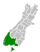
Southland District
Encyclopedia
Southland District is a territorial authority
in the South Island
of New Zealand
. Southland District covers the majority of the land area of Southland Region, although the region also covers Gore District
, Invercargill City
and adjacent territorial waters. It has a land area of 30,400.94 km2, excluding inland waters such as Lake Te Anau
, Lake Manapouri
, and Lake Hauroko
.
Southland District contains the towns of Winton
, Riverton
, Lumsden
and Te Anau
, and the islands south of Foveaux Strait
:
The seat of the District Council is Invercargill
, which, however, is not part of Southland District, but a territorial authority
in its own right.
Two of New Zealand's largest national parks are within the boundaries of Southland District: Fiordland National Park
, and Rakiura National Park
(which covers most of Stewart Island/Rakiura).
Territorial authorities of New Zealand
Territorial authorities are the second tier of local government in New Zealand, below regional councils. There are 67 territorial authorities: 13 city councils, 53 district councils, and the Chatham Islands Council...
in the South Island
South Island
The South Island is the larger of the two major islands of New Zealand, the other being the more populous North Island. It is bordered to the north by Cook Strait, to the west by the Tasman Sea, to the south and east by the Pacific Ocean...
of New Zealand
New Zealand
New Zealand is an island country in the south-western Pacific Ocean comprising two main landmasses and numerous smaller islands. The country is situated some east of Australia across the Tasman Sea, and roughly south of the Pacific island nations of New Caledonia, Fiji, and Tonga...
. Southland District covers the majority of the land area of Southland Region, although the region also covers Gore District
Gore, New Zealand
Gore is a town, surrounding borough, and district in the Southland region of the South Island of New Zealand.-Geography:The Gore District has a land area of 1,251.62 km² and a resident population of...
, Invercargill City
Invercargill
Invercargill is the southernmost and westernmost city in New Zealand, and one of the southernmost cities in the world. It is the commercial centre of the Southland region. It lies in the heart of the wide expanse of the Southland Plains on the Oreti or New River some 18 km north of Bluff,...
and adjacent territorial waters. It has a land area of 30,400.94 km2, excluding inland waters such as Lake Te Anau
Lake Te Anau
Lake Te Anau is in the southwestern corner of the South Island of New Zealand. Its name was originally Te Ana-au, Maori for 'The cave of swirling water'. The lake covers an area of 344 km², making it the second-largest lake by surface area in New Zealand and the largest in the South Island...
, Lake Manapouri
Lake Manapouri
Lake Manapouri is a lake in the South Island of New Zealand. Its name is Maori for "sorrowful heart", though this name is misapplied due to an early cartographical error...
, and Lake Hauroko
Lake Hauroko
Lake Hauroko is located in a mountain valley in Fiordland National Park in the South Island of New Zealand. The long S-shaped lake is 30 kilometres in length and covers an area of 63 km². The surface is at an altitude of 150 metres above sea level, and the lake is 463 metres deep...
.
Southland District contains the towns of Winton
Winton, New Zealand
Winton is a town in Southland, New Zealand. It is located close to the east bank of the Oreti River, 30 kilometres north of Invercargill and 50 kilometres south of Lumsden. It is named after Thomas Winton, a local stockman who lived in the area in the 1850s...
, Riverton
Riverton, New Zealand
Riverton or Aparima is a small town at the south of the South Island of New Zealand. It is in the Southland region and lies at the western end of Oreti Beach, 30 kilometres west of Invercargill on the Southern Scenic Route. It is approx. 45 km from Stewart Island and provides a safe harbour...
, Lumsden
Lumsden, New Zealand
Lumsden is a town in Southland, New Zealand. Lying in a gap in the surrounding hills, it is the location of a major junction halfway along the north-south road from Queenstown to Invercargill, where it is crossed by the east-west road from Gore to Te Anau. The town had a population of 453 as of the...
and Te Anau
Te Anau
Te Anau is a town in the South Island of New Zealand. It is on the eastern shore of Lake Te Anau in Fiordland. Lake Te Anau is the largest lake in the South Island and second only within New Zealand to Lake Taupo. The 2001 census recorded the town's population as 1,857...
, and the islands south of Foveaux Strait
Foveaux Strait
Foveaux Strait separates Stewart Island/Rakiura, New Zealand's third largest island, from the South Island. Three large bays, Te Waewae Bay, Oreti Beach and Toetoes Bay, sweep along the strait's northern coast, which also hosts Bluff township and harbour. Across the strait lie the Solander...
:
- Solander IslandsSolander IslandsThe Solander Islands are a small chain of uninhabited volcanic islets lying at , close to the western end of the Foveaux Strait in southern New Zealand...
- Stewart Island/RakiuraStewart Island/RakiuraStewart Island/Rakiura is the third-largest island of New Zealand. It lies south of the South Island, across Foveaux Strait. Its permanent population is slightly over 400 people, most of whom live in the settlement of Oban.- History and naming :...
- Ruapuke IslandRuapuke IslandRuapuke Island is one of the southernmost islands in New Zealand's main chain of islands. It lies to the southeast of Bluff and northeast of Oban on Stewart Island/Rakiura. The island covers an area of about . It guards the eastern end of Foveaux Strait...
The seat of the District Council is Invercargill
Invercargill
Invercargill is the southernmost and westernmost city in New Zealand, and one of the southernmost cities in the world. It is the commercial centre of the Southland region. It lies in the heart of the wide expanse of the Southland Plains on the Oreti or New River some 18 km north of Bluff,...
, which, however, is not part of Southland District, but a territorial authority
Territorial authorities of New Zealand
Territorial authorities are the second tier of local government in New Zealand, below regional councils. There are 67 territorial authorities: 13 city councils, 53 district councils, and the Chatham Islands Council...
in its own right.
Two of New Zealand's largest national parks are within the boundaries of Southland District: Fiordland National Park
Fiordland National Park
Fiordland National Park occupies the southwest corner of the South Island of New Zealand. It is the largest of the 14 national parks in New Zealand, with an area of 12,500 km², and a major part of the Te Wahipounamu World Heritage site...
, and Rakiura National Park
Rakiura National Park
Rakiura National Park is a nature reserve park located on Stewart Island/Rakiura, New Zealand. It is the 14th of New Zealand's national parks and was officially opened on 9 March 2002. It covers 1,570 km², which is about 85% of Stewart Island, New Zealand's third-largest island...
(which covers most of Stewart Island/Rakiura).