

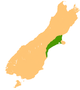
Canterbury Plains
Encyclopedia
Christchurch
Christchurch is the largest city in the South Island of New Zealand, and the country's second-largest urban area after Auckland. It lies one third of the way down the South Island's east coast, just north of Banks Peninsula which itself, since 2006, lies within the formal limits of...
in the Canterbury Region. Their northern extremes are at the foot of the Hundalee Hills
Hundalee Hills
The Hundalee Hills are located close to the borders of Hurunui District and Kaikoura District in Canterbury in the South Island of New Zealand....
in the Hurunui District
Hurunui District
The Hurunui District is a political district on the east coast of New Zealand's South Island, north of Christchurch, New Zealand. It forms part of the Canterbury region and stretches from the east coast to the main divide. Its land area is ....
, and in the south they merge into the plains of North Otago
North Otago
The district of North Otago in New Zealand covers the area of Otago between Shag Point and the Waitaki River, and extends inland to the west as far as the village of Omarama . The large east-coast town of Oamaru serves as North Otago's main centre...
beyond the Waitaki River
Waitaki River
The Waitaki River is a large river in the South Island of New Zealand, some 110 km long. It is the major river of the Mackenzie Basin.It is a braided river which flows through Lake Benmore, Lake Aviemore and Lake Waitaki. These are ultimately fed by three large glacial lakes, Pukaki, Tekapo,...
.
Geography
The Canterbury Plains were formed from quaternaryQuaternary
The Quaternary Period is the most recent of the three periods of the Cenozoic Era in the geologic time scale of the ICS. It follows the Neogene Period, spanning 2.588 ± 0.005 million years ago to the present...
moraine
Moraine
A moraine is any glacially formed accumulation of unconsolidated glacial debris which can occur in currently glaciated and formerly glaciated regions, such as those areas acted upon by a past glacial maximum. This debris may have been plucked off a valley floor as a glacier advanced or it may have...
gravels deposited during glacial periods in the late pleistocene approximately 3 million years to 10,000 years ago. The alluvial
Alluvial plain
An alluvial plain is a relatively flat landform created by the deposition of sediment over a long period of time by one or more rivers coming from highland regions, from which alluvial soil forms...
gravels were then reworked as shingle fans of several of the larger rivers, notably the Waimakariri
Waimakariri River
The Waimakariri River is the largest of the North Canterbury rivers, in the South Island of New Zealand. It flows for 151 kilometres in a generally southeastward direction from the Southern Alps across the Canterbury Plains to the Pacific Ocean....
, the Rakaia
Rakaia River
The Rakaia River is in the Canterbury Plains in New Zealand's South Island. The Rakaia River is one of the largest braided rivers in New Zealand...
, the Selwyn, and the Rangitata
Rangitata River
The Rangitata River is one of the braided rivers that helped form the Canterbury Plains in southern New Zealand. It flows southeast for 120 kilometres from the Southern Alps, entering the Pacific Ocean 30 kilometres northeast of Timaru...
. Part of the Canterbury-Otago tussock grasslands
Canterbury-Otago tussock grasslands
The Canterbury-Otago tussock grasslands are an ecoregion of South Island, New Zealand.-Location and description:This ecoregion is a large area of dry grassy plains between the east coast and the Southern Alps that form the spine of South Island, in the regions of Canterbury and Otago...
the land is suitable for moderately intensive livestock farming, but is prone to droughts, especially when the prevailing wind is from the northwest. At these times, the weather phenomenon known as the Nor'west arch
Nor'west arch
The Nor'west arch is a weather pattern peculiar to the east coast of New Zealand's South Island. For this reason, it is also often referred to as the Canterbury arch. It is shown in an apparent arch of high white cloud in an otherwise clear blue sky over the Southern Alps, and is accompanied by a...
can be seen across much of the plain.
A major earthquake on 4 September 2010
2010 Canterbury earthquake
The 2010 Canterbury earthquake was a 7.1 magnitude earthquake, which struck the South Island of New Zealand at 4:35 am on local time ....
revealed a previously unknown geological fault beneath the Canterbury Plains and created a surface rift that offset features by as much as four meters in places.
Rivers
The rivers of the Canterbury Plains have a distinctive braidedBraided river
A braided river is one of a number of channel types and has a channel that consists of a network of small channels separated by small and often temporary islands called braid bars or, in British usage, aits or eyots. Braided streams occur in rivers with high slope and/or large sediment load...
appearance, which differentiates this area from the plains of North Otago to the south - beyond the Waitaki, the rivers typically have narrower, well-formed channels, rather than spreading across wide shingle depressions, as in Canterbury.
Most of the population of Canterbury lives in a series of large and small towns arranged northeast to southwest along the plains, connected by State Highway 1
New Zealand State Highway network
The New Zealand State Highway network is the major national highway network in New Zealand. Just under 100 roads in both the North and South Islands are State Highways...
and the Main South railway line
Main South Line
The Main South Line, sometimes referred to as part of the South Island Main Trunk Railway, is a railroad line that runs north and south from Lyttelton in New Zealand through Christchurch and along the east coast of the South Island to Invercargill via Dunedin...
. These include Christchurch, Ashburton
Ashburton, New Zealand
Ashburton is a town and district in the Canterbury Region on the east coast of the South Island of New Zealand. It is the third-largest centre in Canterbury, after Christchurch and Timaru. The area around Ashburton is frequently referred to as Mid Canterbury, which is also the name of the...
and Timaru
Timaru
TimaruUrban AreaPopulation:27,200Extent:Former Timaru City CouncilTerritorial AuthorityName:Timaru District CouncilPopulation:42,867 Land area:2,736.54 km² Mayor:Janie AnnearWebsite:...
, and the smaller Kaiapoi
Kaiapoi
Kaiapoi is a town in the Canterbury region of the South Island of New Zealand, located close to the mouth of the Waimakariri River, and approximately 17 kilometres north of Christchurch....
, Dunsandel
Dunsandel
Dunsandel is a small rural township in the Canterbury Region of the South Island, New Zealand. The town is located on the Canterbury Plains just south of the Selwyn River and about 40 km south of Christchurch. Dunsandel is a junction town on SH1, halfway between Christchurch and Ashburton,...
, Rakaia
Rakaia
The town of Rakaia is seated close to the southern banks of the Rakaia River on the Canterbury Plains in New Zealand's South Island, on State Highway 1 and the Main South Line. Immediately north of the township are the country's longest road bridge and longest rail bridge, both of which cross the...
, Temuka
Temuka
Temuka is a town on New Zealand's Canterbury Plains, 15 kilometres north of Timaru and 142 km south of Christchurch. It is located at the centre of a rich sheep and dairy farming region, for which it is a service town.-History:...
, and Glenavy
Glenavy, New Zealand
Glenavy is a locality in the South Island of New Zealand. It is located at the southern extreme of the Canterbury region on the alluvial fan of the Waitaki River, three kilometres from the river's outflow into the Pacific Ocean....
. Other towns on the plains include Rangiora, Leeston
Leeston
Leeston is a small town on the Canterbury Plains in the South Island of New Zealand. It is located 40 kilometres southwest of Christchurch, between the shore of Lake Ellesmere and the mouth of the Rakaia River...
, Lincoln
Lincoln, New Zealand
Lincoln is a town in the Selwyn District of Canterbury, New Zealand. The town has a population of 2,727.-Location:It is located on the Canterbury Plains to the west of Banks Peninsula, 22 kilometres south of Christchurch.-History:...
, Darfield
Darfield, New Zealand
Darfield is a town in the Selwyn District of the South Island of New Zealand. It is located 35 kilometres west from the outskirts of Christchurch, New Zealand on State Highway 73 and the town is on the Midland railway line, route of the famous TranzAlpine train service...
, Geraldine
Geraldine, New Zealand
Geraldine is a town in the Canterbury Region on the South Island of New Zealand. It is about 140 km south of Christchurch, and inland from Timaru, which is 35 km to the south...
, Methven
Methven, New Zealand
Methven is a small town in the Canterbury region of the South Island of New Zealand. It is located near the western edge of the Canterbury Plains, 35 kilometres north of Ashburton. It was originally the railhead of a short branch railway off the Main South Line...
and Waimate
Waimate
WaimateUrban AreaPopulation:2,835 Extent:Territorial AuthorityName:Waimate District CouncilPopulation:7,206 Land area:3,582.19 km² Mayor:John ColesWebsite:...
.