

Lake Pukaki
Encyclopedia
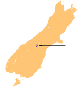
Lake Pukaki is the largest of three roughly parallel alpine lake
s running north-south along the northern edge of the Mackenzie Basin
on New Zealand
's South Island
. The others are Lakes Tekapo and Ohau. All three lakes were created when the terminal moraine
s of receding glaciers blocked their respective valleys, forming moraine-dammed lakes.
The glacial feed to the lakes gives them a distinctive blue colour, created by glacial flour, the extremely finely ground rock particles from the glaciers.
Lake Pukaki covers an area of 178.7 km², and the surface elevation of the lake normally ranges from 518.2 to 532 metres above sea level.
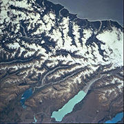
 The lake is fed at its northern end by the braided Tasman River
, which has its source in the Tasman
and Hooker Glacier
s, close to Aoraki/Mount Cook
. Good views of the mountain, 70 kilometres to the north, can be had from the southern shore of the lake.
The lake is now part of the Waitaki hydroelectric scheme.
The lake's original outflow was at its southern end, into the Pukaki River
.
The outflow has been dammed, and canals carry water from Lake Pukaki and Lake Ohau
through the Ohau A power station to Lake Ruataniwha
.
Pukaki is also fed by the waters of Lake Tekapo
, which are diverted through a canal to a power station on Pukaki's eastern shore (Tekapo B station). The lake has been raised twice to increase storage capacity (9m in the 1940s, 37m in the 1970s), submerging Five Pound Note Island, which once appeared on New Zealand's five pound note. The current lake has an operating range of 13.8 m (the level within which it can be artificially raised or lowered), giving it an energy storage capacity of 1,595 GWh). Along with Lake Tekapo's 770 GWh storage, it provides over half New Zealand's hydroelectricity storage capacity.
Lake
A lake is a body of relatively still fresh or salt water of considerable size, localized in a basin, that is surrounded by land. Lakes are inland and not part of the ocean and therefore are distinct from lagoons, and are larger and deeper than ponds. Lakes can be contrasted with rivers or streams,...
s running north-south along the northern edge of the Mackenzie Basin
Mackenzie Basin
The Mackenzie Basin , is an elliptical intermontane basin, located in the Mackenzie and Waitaki Districts, near the centre of the South Island of New Zealand. It is the largest such basin in New Zealand...
on New Zealand
New Zealand
New Zealand is an island country in the south-western Pacific Ocean comprising two main landmasses and numerous smaller islands. The country is situated some east of Australia across the Tasman Sea, and roughly south of the Pacific island nations of New Caledonia, Fiji, and Tonga...
's South Island
South Island
The South Island is the larger of the two major islands of New Zealand, the other being the more populous North Island. It is bordered to the north by Cook Strait, to the west by the Tasman Sea, to the south and east by the Pacific Ocean...
. The others are Lakes Tekapo and Ohau. All three lakes were created when the terminal moraine
Moraine
A moraine is any glacially formed accumulation of unconsolidated glacial debris which can occur in currently glaciated and formerly glaciated regions, such as those areas acted upon by a past glacial maximum. This debris may have been plucked off a valley floor as a glacier advanced or it may have...
s of receding glaciers blocked their respective valleys, forming moraine-dammed lakes.
The glacial feed to the lakes gives them a distinctive blue colour, created by glacial flour, the extremely finely ground rock particles from the glaciers.
Lake Pukaki covers an area of 178.7 km², and the surface elevation of the lake normally ranges from 518.2 to 532 metres above sea level.
Tasman River
The Tasman River is an alpine braided river flowing through Canterbury, in New Zealand's South Island.The river's headwaters are in Aoraki/Mount Cook National Park, where it is the outflow of the Tasman and Murchison Glaciers and also, via a short tributary, of the Hooker and Mueller Glaciers.It...
, which has its source in the Tasman
Tasman Glacier
The Tasman Glacier is the largest of several glaciers which flow south and east towards the Mackenzie Basin from the Southern Alps in New Zealand's South Island. It is New Zealand's longest glacier.-Geography:...
and Hooker Glacier
Hooker Glacier
Hooker Glacier is one of several glaciers close to the slopes of Aoraki/Mount Cook in the Southern Alps of New Zealand. Though not as large as its neighbour, the Tasman Glacier, it is still impressive, and is some 11 kilometres in length...
s, close to Aoraki/Mount Cook
Aoraki/Mount Cook
Aoraki / Mount Cook is the highest mountain in New Zealand, reaching .It lies in the Southern Alps, the mountain range which runs the length of the South Island. A popular tourist destination, it is also a favourite challenge for mountain climbers...
. Good views of the mountain, 70 kilometres to the north, can be had from the southern shore of the lake.
The lake is now part of the Waitaki hydroelectric scheme.
The lake's original outflow was at its southern end, into the Pukaki River
Pukaki River
The Pukaki River flows through the Mackenzie Basin, Canterbury, in New Zealand's South Island.Originally, the river flowed southwest for 15 kilometres from the southern end of Lake Pukaki before joining with the Tekapo River and flowing into the northern end of Lake Benmore...
.
The outflow has been dammed, and canals carry water from Lake Pukaki and Lake Ohau
Lake Ohau
Lake Ohau is a glacial lake in the Mackenzie Basin of New Zealand's South Island. It is fed by the Hopkins and Dobson rivers, which have their headwaters in the Southern Alps, and has its outflow in the Ohau River, which itself feeds into the Waitaki River hydroelectric project.Ohau is the smallest...
through the Ohau A power station to Lake Ruataniwha
Lake Ruataniwha
Lake Ruataniwha is located in the Mackenzie Basin in New Zealand's South Island. An artificial lake, it was formed as part of the Waitaki hydroelectric project....
.
Pukaki is also fed by the waters of Lake Tekapo
Lake Tekapo
Lake Tekapo is the second-largest of three roughly parallel lakes running north–south along the northern edge of the Mackenzie Basin in the South Island of New Zealand...
, which are diverted through a canal to a power station on Pukaki's eastern shore (Tekapo B station). The lake has been raised twice to increase storage capacity (9m in the 1940s, 37m in the 1970s), submerging Five Pound Note Island, which once appeared on New Zealand's five pound note. The current lake has an operating range of 13.8 m (the level within which it can be artificially raised or lowered), giving it an energy storage capacity of 1,595 GWh). Along with Lake Tekapo's 770 GWh storage, it provides over half New Zealand's hydroelectricity storage capacity.
Further reading
- J. Irwin, 1971
External links
- Department of Conservation - recreational opportunites