
Lake Tekapo
Encyclopedia
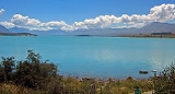
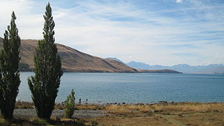
Lake Tekapo is the second-largest of three roughly parallel lake
s running north–south along the northern edge of the Mackenzie Basin
in the South Island
of New Zealand
(the others are Lake Pukaki and Lake Ohau). It covers an area of 83 square kilometres (32 sq mi), and is at an altitude of 700 metres (2,296.6 ft) above sea level.
The lake is fed at its northern end by the braided Godley River
, which has its source in the Southern Alps
to the north. The lake is a popular tourist destination, and several resort hotels are located at the township of Lake Tekapo
at the lake's southern end. The Lake Tekapo Regional Park, administered by Environment Canterbury, is located on the southern shore of the lake.
An astronomical observatory is located at Mount John
, which is to the north of the town, and south of the small Lake Alexandrina
.
. In 1938 construction commenced on a power station, originally due to be finished in 1943 but halted by the war in 1942. At the same time, control gates were constructed to regulate outflows to the Waitaki Dam downstream. Work restarted in 1944, and the power station now known as "Tekapo A" came online in 1951.
Water from the lake is diverted through a 1.4 kilometres (4,593.2 ft) tunnel under the town to the power station, with the water originally being returned to the river. With development of the Upper Waitaki hydroelectric scheme in the 1970s, water is now fed into a 26 kilometres (16.2 mi) canal
which leads to Tekapo B on the shores of Lake Pukaki
.
Following a turbine failure in 1986, a new Kaplan turbine
was installed, with a more efficient design and higher output (42 000 HP) than the original. Today, the power station produces an average of 160 GWh annually, from a 25.2 MW capacity generator. The net head of the station is 30.5 m.
Both Tekapo A and Tekapo B hydro stations are to be refurbished following the upgrade of Benmore
and Waitaki
.
Since 1 June 2011, Tekapo A and B stations are owned by Genesis Energy.
architect R.S.D. Harman, based on sketches by a local artist, Esther Hope. The church is arguably one of the most photographed in New Zealand, and features an altar window that frames stunning views of the lake and mountains.
Lake
A lake is a body of relatively still fresh or salt water of considerable size, localized in a basin, that is surrounded by land. Lakes are inland and not part of the ocean and therefore are distinct from lagoons, and are larger and deeper than ponds. Lakes can be contrasted with rivers or streams,...
s running north–south along the northern edge of the Mackenzie Basin
Mackenzie Basin
The Mackenzie Basin , is an elliptical intermontane basin, located in the Mackenzie and Waitaki Districts, near the centre of the South Island of New Zealand. It is the largest such basin in New Zealand...
in the South Island
South Island
The South Island is the larger of the two major islands of New Zealand, the other being the more populous North Island. It is bordered to the north by Cook Strait, to the west by the Tasman Sea, to the south and east by the Pacific Ocean...
of New Zealand
New Zealand
New Zealand is an island country in the south-western Pacific Ocean comprising two main landmasses and numerous smaller islands. The country is situated some east of Australia across the Tasman Sea, and roughly south of the Pacific island nations of New Caledonia, Fiji, and Tonga...
(the others are Lake Pukaki and Lake Ohau). It covers an area of 83 square kilometres (32 sq mi), and is at an altitude of 700 metres (2,296.6 ft) above sea level.
The lake is fed at its northern end by the braided Godley River
Godley River
The Godley River is an alpine braided river flowing through Canterbury, in New Zealand's South Island.The river's headwaters are in Aoraki/Mount Cook National Park. It flows south for 30 kilometres from the Southern Alps into the top end of the glacial lake Tekapo, this forming part of the ultimate...
, which has its source in the Southern Alps
Southern Alps
The Southern Alps is a mountain range extending along much of the length of New Zealand's South Island, reaching its greatest elevations near the island's western side...
to the north. The lake is a popular tourist destination, and several resort hotels are located at the township of Lake Tekapo
Lake Tekapo (town)
TekapoUrban AreaPopulation:Extent:Territorial AuthorityName:Mackenzie District CouncilPopulation:Mayor:Website:Extent:Regional councilName:Environment Canterbury...
at the lake's southern end. The Lake Tekapo Regional Park, administered by Environment Canterbury, is located on the southern shore of the lake.
An astronomical observatory is located at Mount John
Mount John University Observatory
Mount John University Observatory , is New Zealand's premier astronomical research observatory. It is situated at ASL atop Mount John at the northern end of the Mackenzie Basin in the South Island, and was established in 1965...
, which is to the north of the town, and south of the small Lake Alexandrina
Lake Alexandrina, New Zealand
Lake Alexandrina is a lake located in the Mackenzie Basin of New Zealand's South Island. It lies immediately to the west of the much larger Lake Tekapo and further to the east of Lake Pukaki, located to the north of Lake Tekapo township...
.
Hydroelectricity
The lake's original outflow was at its southern end, into the Tekapo RiverTekapo River
The Tekapo River flows occasionally through the Mackenzie Basin, Canterbury, in New Zealand's South Island, although the riverbed is now often dry in the upper reaches it maintains a constant flow below the confluence of several tributaries notably the Merryburn, Forks, and Greys streams...
. In 1938 construction commenced on a power station, originally due to be finished in 1943 but halted by the war in 1942. At the same time, control gates were constructed to regulate outflows to the Waitaki Dam downstream. Work restarted in 1944, and the power station now known as "Tekapo A" came online in 1951.
Water from the lake is diverted through a 1.4 kilometres (4,593.2 ft) tunnel under the town to the power station, with the water originally being returned to the river. With development of the Upper Waitaki hydroelectric scheme in the 1970s, water is now fed into a 26 kilometres (16.2 mi) canal
Canal
Canals are man-made channels for water. There are two types of canal:#Waterways: navigable transportation canals used for carrying ships and boats shipping goods and conveying people, further subdivided into two kinds:...
which leads to Tekapo B on the shores of Lake Pukaki
Lake Pukaki
Lake Pukaki is the largest of three roughly parallel alpine lakes running north-south along the northern edge of the Mackenzie Basin on New Zealand's South Island. The others are Lakes Tekapo and Ohau...
.
Following a turbine failure in 1986, a new Kaplan turbine
Kaplan turbine
The Kaplan turbine is a propeller-type water turbine which has adjustable blades. It was developed in 1913 by the Austrian professor Viktor Kaplan, who combined automatically adjusted propeller blades with automatically adjusted wicket gates to achieve efficiency over a wide range of flow and...
was installed, with a more efficient design and higher output (42 000 HP) than the original. Today, the power station produces an average of 160 GWh annually, from a 25.2 MW capacity generator. The net head of the station is 30.5 m.
Both Tekapo A and Tekapo B hydro stations are to be refurbished following the upgrade of Benmore
Benmore Dam
Benmore Dam is the largest dam within the Waitaki power scheme, located in the Canterbury Region of New Zealand's South Island. There are eight other power stations in the valley....
and Waitaki
Lake Waitaki
Lake Waitaki is the smallest, oldest and farthest downstream of the three man-made lakes of the Waitaki hydroelectric project in New Zealand's South Island. It lies below lakes Aviemore and Benmore on the Waitaki River, close to the town of Kurow...
.
Since 1 June 2011, Tekapo A and B stations are owned by Genesis Energy.
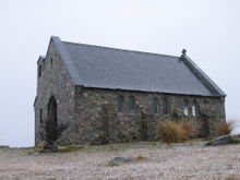
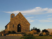
Church of the Good Shepherd
Situated on the shores of Lake Tekapo is the Church of the Good Shepherd, which, in 1935, was the first church built in the Mackenzie Basin. The church at Burkes Pass, St Patrick's built in 1872 was the first church built by pioneers as a joint community effort, by Anglicans Presbyterian and Catholic settlers. Also a joint venture between Presbyterians and Anglicans, St Columba in Fairlie was built in 1879. The church at Lake Tekapo was designed by ChristchurchChristchurch
Christchurch is the largest city in the South Island of New Zealand, and the country's second-largest urban area after Auckland. It lies one third of the way down the South Island's east coast, just north of Banks Peninsula which itself, since 2006, lies within the formal limits of...
architect R.S.D. Harman, based on sketches by a local artist, Esther Hope. The church is arguably one of the most photographed in New Zealand, and features an altar window that frames stunning views of the lake and mountains.
Bronze sheepdog
Close to the Church of the Good Shepherd is one of New Zealand's best known public monuments, a bronze statue of a New Zealand Collie sheepdog.Gallery
 |
 |
 |