

Southland Region
Encyclopedia
New Zealand
New Zealand is an island country in the south-western Pacific Ocean comprising two main landmasses and numerous smaller islands. The country is situated some east of Australia across the Tasman Sea, and roughly south of the Pacific island nations of New Caledonia, Fiji, and Tonga...
's southernmost region
Regions of New Zealand
The region is the top tier of local government in New Zealand. There are 16 regions of New Zealand. Eleven are governed by an elected regional council, while five are governed by territorial authorities which also perform the functions of a regional council and thus are known as unitary authorities...
and is also a district
Territorial authorities of New Zealand
Territorial authorities are the second tier of local government in New Zealand, below regional councils. There are 67 territorial authorities: 13 city councils, 53 district councils, and the Chatham Islands Council...
within that region. It consists mainly of the southwestern portion of the South Island
South Island
The South Island is the larger of the two major islands of New Zealand, the other being the more populous North Island. It is bordered to the north by Cook Strait, to the west by the Tasman Sea, to the south and east by the Pacific Ocean...
and Stewart Island / Rakiura. The region covers over 3.1 million hectare
Hectare
The hectare is a metric unit of area defined as 10,000 square metres , and primarily used in the measurement of land. In 1795, when the metric system was introduced, the are was defined as being 100 square metres and the hectare was thus 100 ares or 1/100 km2...
s and spans over 3,400 km of coastal stretch.
History
Southland was a scene of early extended contact between Europeans and Maori, in this case sealers, whalers and missionaries - Wohlers at RuapukeRuapuke
Ruapuke is a small farming community in the Waikato region on the slopes of rocky mountains, between Raglan and Kawhia in New Zealand. It comprises a handful of families, some of whom have lived there for many generations. The residents, predominantly sheep and cattle farmers, all traverse Ruapuke...
. In 1853, Walter Mantell
Walter Mantell
Walter Baldock Durrant Mantell was a 19th century New Zealand scientist, politician, and Land Purchase Commissioner. He was a founder and first secretary of the New Zealand Institute, and discovered and collected Moa remains....
purchased Murihiku from local Maori iwi, claiming the land for European settlement. Over successive decades, present-day Southland and Otago were settled by large numbers of Scottish
Scottish people
The Scottish people , or Scots, are a nation and ethnic group native to Scotland. Historically they emerged from an amalgamation of the Picts and Gaels, incorporating neighbouring Britons to the south as well as invading Germanic peoples such as the Anglo-Saxons and the Norse.In modern use,...
settlers. Immigration to New Zealand had been precipitated by an economic depression in Scotland and a schism
Schism (religion)
A schism , from Greek σχίσμα, skhísma , is a division between people, usually belonging to an organization or movement religious denomination. The word is most frequently applied to a break of communion between two sections of Christianity that were previously a single body, or to a division within...
between the Church of Scotland
Church of Scotland
The Church of Scotland, known informally by its Scots language name, the Kirk, is a Presbyterian church, decisively shaped by the Scottish Reformation....
and the Free Church of Scotland.
In 1852, James Menzies
James Alexander Robertson Menzies
James Alexander Robertson Menzies was the first Superintendent of the Southland Province in New Zealand from 3 August 1861 to November 1864 during its breakaway from Otago Province...
, leader of the Southland separatist movement, became the first Superintendent of the tiny Southland electorate which was still part of the large Otago Region. Under the influence of Menzies, Southland Province
Southland Province
The Southland Province was a province of New Zealand from March 1861 until the province rejoined with Otago Province in 1870.-History:When provinces were formed in 1853, the southern part of New Zealand belonged to Otago Province...
(a small part of the present Region, centred on Invercargill
Invercargill
Invercargill is the southernmost and westernmost city in New Zealand, and one of the southernmost cities in the world. It is the commercial centre of the Southland region. It lies in the heart of the wide expanse of the Southland Plains on the Oreti or New River some 18 km north of Bluff,...
) seceded from Otago in 1861 following the escalation of political tensions.
However, rising debt forced Southland to rejoin Otago in 1870 and the province was abolished entirely, when the Abolition of the Provinces Act came into force on 1 Nov 1876. In the 1880s, the development of an export industry based on butter
Butter
Butter is a dairy product made by churning fresh or fermented cream or milk. It is generally used as a spread and a condiment, as well as in cooking applications, such as baking, sauce making, and pan frying...
and cheese
Cheese
Cheese is a generic term for a diverse group of milk-based food products. Cheese is produced throughout the world in wide-ranging flavors, textures, and forms....
encouraged the growth of dairy farming
Dairy farming
Dairy farming is a class of agricultural, or an animal husbandry, enterprise, for long-term production of milk, usually from dairy cows but also from goats and sheep, which may be either processed on-site or transported to a dairy factory for processing and eventual retail sale.Most dairy farms...
in Southland. Consequently, the colony's first dairy factory was established at Edendale
Edendale, New Zealand
Edendale is a town in the Southland region of New Zealand's South Island. According to the 2001 New Zealand Census of Population and Dwellings, it has a population of 570 , representing a rise of 0.5% or 3 people since the 1996 census.State Highway 1 passes through Edendale as it runs between...
in 1882. Much of this export went to the United Kingdom
United Kingdom
The United Kingdom of Great Britain and Northern IrelandIn the United Kingdom and Dependencies, other languages have been officially recognised as legitimate autochthonous languages under the European Charter for Regional or Minority Languages...
.
The region's largest flood on 27 January 1984 led to a state of emergency being declared, evacuation of 4,000 people, and damage exceeding $100 million (in 1984 dollars).
Structure

Settlements
Southland's two principal urban settlementUrban settlement
Urban settlement may refer to:*Urban area, area with high density of human-created structures*Municipal urban settlement, a type of municipal formation in Russia*Urban settlement, a synonym for urban localities in Russia...
s are the city of Invercargill and the town of Gore
Gore, New Zealand
Gore is a town, surrounding borough, and district in the Southland region of the South Island of New Zealand.-Geography:The Gore District has a land area of 1,251.62 km² and a resident population of...
. Southland covers an area of 28,681 square kilometres. In the it had a population of , making it one of New Zealand's most sparsely populated areas. The sizable western part Fiordland
Fiordland
Fiordland is a geographic region of New Zealand that is situated on the south-western corner of the South Island, comprising the western-most third of Southland. Most of Fiordland is dominated by the steep sides of the snow-capped Southern Alps, deep lakes and its ocean-flooded, steep western valleys...
is almost empty of permanent human inhabitation.
Representation
Southland is divided into two parliamentary electorateElectoral district
An electoral district is a distinct territorial subdivision for holding a separate election for one or more seats in a legislative body...
s. The large rural electorate of Clutha-Southland, held by Bill English
Bill English
Simon William "Bill" English is the Deputy Prime Minister, Minister of Finance and Minister of Infrastructure of New Zealand.English entered parliament in 1990 as a National party MP representing the Wallace electorate...
, also includes some of the neighbouring Otago
Otago
Otago is a region of New Zealand in the south of the South Island. The region covers an area of approximately making it the country's second largest region. The population of Otago is...
Region. The seat of Invercargill
Invercargill (New Zealand electorate)
Invercargill is an electorate of the Parliament of New Zealand that has existed since 1866. The current representative is Eric Roy.-Population centres:The electorate covers Invercargill city and the surrounding rural area, including Stewart Island / Rakiura...
is held by Eric Roy
Eric Roy
Eric Wilbur Roy is a New Zealand politician. He is a National Party Member of Parliament , being first elected in 1993.-Early years:...
. Both are members of the governing National Party
New Zealand National Party
The New Zealand National Party is the largest party in the New Zealand House of Representatives and in November 2008 formed a minority government with support from three minor parties.-Policies:...
. Under the Maori seats
Maori seats
In New Zealand politics, Māori electorates, colloquially also called Māori seats, are a special category of electorate that gives reserved positions to representatives of Māori in the New Zealand Parliament...
system, Southland is part of the large Te Tai Tonga election which covers the entire South Island and the surrounding islands, and is currently held by the Maori Party
Maori Party
The Māori Party, a political party in New Zealand, was formed on 7 July 2004. The Party is guided by eight constitutional "kaupapa", or Party objectives. Tariana Turia formed the Māori Party after resigning from the Labour Party where she had been a Cabinet Minister in the Fifth Labour-led...
MP Rahui Katene
Rahui Katene
Rahui Katene is a New Zealand politician. She was elected to the 49th New Zealand Parliament at the 2008 general election representing the Māori Party in the seat of Te Tai Tonga, but lost in the 2011 general election to Labour's Rino Tirikatene.- Ancestry :...
.
Local government
Regional responsibilities are handled by the Southland Regional CouncilSouthland Regional Council
The Southland Regional Council is the southernmost regional council in New Zealand. In 2006, it had an operating revenue of NZ$19.6 million, NZ$7.1 million of this from rates revenue....
(Environment Southland). Three Territorial Authorities
Territorial authorities of New Zealand
Territorial authorities are the second tier of local government in New Zealand, below regional councils. There are 67 territorial authorities: 13 city councils, 53 district councils, and the Chatham Islands Council...
fall entirely within Southland. The Invercargill City Council governs Invercargill itself, together with some adjoining rural areas. Much of the remaining area of Southland, including all of Stewart Island/Rakiura
Stewart Island/Rakiura
Stewart Island/Rakiura is the third-largest island of New Zealand. It lies south of the South Island, across Foveaux Strait. Its permanent population is slightly over 400 people, most of whom live in the settlement of Oban.- History and naming :...
, falls within the Southland District, which is administered by its own Council, also based in Invercargill. The Gore District Council administers the town of the same name and its rural hinterland.
National parks
The region is home to two national parks: Fiordland National ParkFiordland
Fiordland is a geographic region of New Zealand that is situated on the south-western corner of the South Island, comprising the western-most third of Southland. Most of Fiordland is dominated by the steep sides of the snow-capped Southern Alps, deep lakes and its ocean-flooded, steep western valleys...
and Rakiura National Park
Rakiura National Park
Rakiura National Park is a nature reserve park located on Stewart Island/Rakiura, New Zealand. It is the 14th of New Zealand's national parks and was officially opened on 9 March 2002. It covers 1,570 km², which is about 85% of Stewart Island, New Zealand's third-largest island...
. The former which covers 7,860 square kilometres; making it New Zealand's largest national park
National park
A national park is a reserve of natural, semi-natural, or developed land that a sovereign state declares or owns. Although individual nations designate their own national parks differently A national park is a reserve of natural, semi-natural, or developed land that a sovereign state declares or...
. Southland also includes Stewart Island, 85% of which is covered by Rakiura National Park
Rakiura National Park
Rakiura National Park is a nature reserve park located on Stewart Island/Rakiura, New Zealand. It is the 14th of New Zealand's national parks and was officially opened on 9 March 2002. It covers 1,570 km², which is about 85% of Stewart Island, New Zealand's third-largest island...
. Both parks are administrated by the Department of Conservation.
Geography
Politically, Southland proper extends from FiordlandFiordland
Fiordland is a geographic region of New Zealand that is situated on the south-western corner of the South Island, comprising the western-most third of Southland. Most of Fiordland is dominated by the steep sides of the snow-capped Southern Alps, deep lakes and its ocean-flooded, steep western valleys...
in the west past the Mataura River
Mataura River
The Mataura River is in the Southland Region of the South Island of New Zealand. It is 190 kilometres in length.The river's headwaters are located in mountains to the south of Lake Wakatipu. From there it flows southeast towards Gore, where it turns southward...
to the Catlins
The Catlins
The Catlins comprises an area in the southeastern corner of the South Island of New Zealand. The area lies between Balclutha and Invercargill, straddling the boundary between the Otago and Southland regions...
the east. To the north, Southland is framed by the Darran and Eyre Mountains. Farther south lies Stewart Island which is separated from the mainland by the Foveaux Strait
Foveaux Strait
Foveaux Strait separates Stewart Island/Rakiura, New Zealand's third largest island, from the South Island. Three large bays, Te Waewae Bay, Oreti Beach and Toetoes Bay, sweep along the strait's northern coast, which also hosts Bluff township and harbour. Across the strait lie the Solander...
.
Southland contains New Zealand's highest waterfall—the Browne Falls
Browne Falls
Browne Falls is a waterfall above Doubtful Sound, which is located in Fiordland National Park, New Zealand. In breathtaking scenery amidst temperate rain forest, the falls cascade down to the fiord near Hall Arm...
. Lake Hauroko
Lake Hauroko
Lake Hauroko is located in a mountain valley in Fiordland National Park in the South Island of New Zealand. The long S-shaped lake is 30 kilometres in length and covers an area of 63 km². The surface is at an altitude of 150 metres above sea level, and the lake is 463 metres deep...
is the deepest lake
Lake
A lake is a body of relatively still fresh or salt water of considerable size, localized in a basin, that is surrounded by land. Lakes are inland and not part of the ocean and therefore are distinct from lagoons, and are larger and deeper than ponds. Lakes can be contrasted with rivers or streams,...
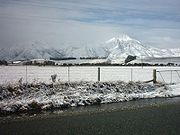
in the country. The highest peak in Southland is Mount Tutoko
Mount Tutoko
Mount Tutoko is the highest peak in Fiordland National Park, in southwest New Zealand. It lies between the Hollyford Valley and Milford Sound, 15 kilometres due north of the Homer Tunnel, and rises to a height of 2756 m...
, which is part of the Darran mountains. The largest lake in Southland is Lake Te Anau
Lake Te Anau
Lake Te Anau is in the southwestern corner of the South Island of New Zealand. Its name was originally Te Ana-au, Maori for 'The cave of swirling water'. The lake covers an area of 344 km², making it the second-largest lake by surface area in New Zealand and the largest in the South Island...
followed by Lake Manapouri
Lake Manapouri
Lake Manapouri is a lake in the South Island of New Zealand. Its name is Maori for "sorrowful heart", though this name is misapplied due to an early cartographical error...
which both lie within the boundaries of Fiordland National Park
Fiordland National Park
Fiordland National Park occupies the southwest corner of the South Island of New Zealand. It is the largest of the 14 national parks in New Zealand, with an area of 12,500 km², and a major part of the Te Wahipounamu World Heritage site...
. Established on 20 February 1905, it is the largest national park in New Zealand—covering much of Fiordland which is devoid of human settlement.
Fiordland's terrain is dominated by mountains, fjord
Fjord
Geologically, a fjord is a long, narrow inlet with steep sides or cliffs, created in a valley carved by glacial activity.-Formation:A fjord is formed when a glacier cuts a U-shaped valley by abrasion of the surrounding bedrock. Glacial melting is accompanied by rebound of Earth's crust as the ice...
s and glacial lake
Glacial lake
A glacial lake is a lake with origins in a melted glacier. Near the end of the last glacial period, roughly 10,000 years ago, glaciers began to retreat. A retreating glacier often left behind large deposits of ice in hollows between drumlins or hills. As the ice age ended, these melted to create...
s carved up by glaciations during the last ice age, between 75,000 to 15,000 years ago. The region's coast is dotted by several fjords and other sea inlets which stretch from Milford Sound
Milford Sound
Milford Sound is a fjord in the south west of New Zealand's South Island, within Fiordland National Park, Piopiotahi Marine Reserve, and the Te Wahipounamu World Heritage site...
in the north to Preservation Inlet
Preservation Inlet
Preservation Inlet is the southernmost fjord in Fiordland National Park and lies on the southwest corner of the South Island of New Zealand.-Geography:...
to the south. Farther north and east of Fiordland lie the Darran and Eyre Mountains which are part of the block of schist
Schist
The schists constitute a group of medium-grade metamorphic rocks, chiefly notable for the preponderance of lamellar minerals such as micas, chlorite, talc, hornblende, graphite, and others. Quartz often occurs in drawn-out grains to such an extent that a particular form called quartz schist is...
that extends into neighboring Central Otago
Central Otago
Central Otago is the inland part of the New Zealand region of Otago in the South Island. The area commonly known as Central Otago includes both the Central Otago District and the Queenstown-Lakes District to the west....
.
Farther east of the Waiau River
Waiau River, Southland
Waiau River is the largest river in the Southland Region of New Zealand. It is the outflow of Lake Te Anau, flowing from it into Lake Manapouri 10 kilometres to the south, and from there flows south for 70 kilometres before reaching the Foveaux Strait eight kilometres south of Tuatapere...
, the Southland Plains
Southland Plains
The Southland Plains is a general name given to several areas of low-lying land in the South Island of New Zealand, separated by the rise of the Hokonui Hills in the north. It forms a sizeable area of Southland Region and encompasses its two principal settlements the city of Invercargill and the...
predominate which include some of New Zealand's most fertile farmlands. The region's two principal settlements Invercargill
Invercargill
Invercargill is the southernmost and westernmost city in New Zealand, and one of the southernmost cities in the world. It is the commercial centre of the Southland region. It lies in the heart of the wide expanse of the Southland Plains on the Oreti or New River some 18 km north of Bluff,...
and Gore
Gore, New Zealand
Gore is a town, surrounding borough, and district in the Southland region of the South Island of New Zealand.-Geography:The Gore District has a land area of 1,251.62 km² and a resident population of...
are located on the plains. The Plains extend from the Waiau River
Waiau River, Southland
Waiau River is the largest river in the Southland Region of New Zealand. It is the outflow of Lake Te Anau, flowing from it into Lake Manapouri 10 kilometres to the south, and from there flows south for 70 kilometres before reaching the Foveaux Strait eight kilometres south of Tuatapere...
in the west to the Mataura River
Mataura River
The Mataura River is in the Southland Region of the South Island of New Zealand. It is 190 kilometres in length.The river's headwaters are located in mountains to the south of Lake Wakatipu. From there it flows southeast towards Gore, where it turns southward...
to the east. It can be divided into three broad areas: the Southland plain proper, the Waimea Plains
Waimea Plains
The Waimea Plains is the name of two areas of land at opposite ends of the South Island of New Zealand.-Waimea Plains, Tasman:The northern area with this name is a small but fertile area of low-lying land south of the city of Nelson...
and the lower Waiau plain to the west near the Waiau river. Off the coast of Southland lies the Great South Basin
Great South Basin
The Great South Basin is an area of mainly sea to the south of the South Island of New Zealand.Starting in the 1960s, the area was explored and drilled for oil deposits by various minerals companies, mostly international, but by 1984 all of these companies had left empty-handed...
which stretches over 500,000 km2 (covering an area 1.5 times New Zealand’s land mass). It is one of the country's largest undeveloped offshore petroleum basins with prospects for both oil and gas.
Climate
Weather conditions in Southland are cooler and wetter than the other regions of New Zealand due to its distance from the EquatorEquator
An equator is the intersection of a sphere's surface with the plane perpendicular to the sphere's axis of rotation and containing the sphere's center of mass....
. However, they can be broken down into three types: the temperate oceanic climate of the coastal regions, the continental climate of the interior and the wetter mountain climate of Fiordland
Fiordland
Fiordland is a geographic region of New Zealand that is situated on the south-western corner of the South Island, comprising the western-most third of Southland. Most of Fiordland is dominated by the steep sides of the snow-capped Southern Alps, deep lakes and its ocean-flooded, steep western valleys...
to the west. Due to its closer proximity to the South Pole
South Pole
The South Pole, also known as the Geographic South Pole or Terrestrial South Pole, is one of the two points where the Earth's axis of rotation intersects its surface. It is the southernmost point on the surface of the Earth and lies on the opposite side of the Earth from the North Pole...
, the Aurora Australis or "Southern Lights" are more commonly seen than in other regions.
The coastal regions have cool summers and mild winters. The mean daily temperature varies from 5.2°C in July to 14.9°C in January. Rainfall varies from 900mm to 1300 mm annually with rainfall being more frequent in coastal areas and rainbows being a regular occurrence in the region. Summers are temperable with downpours and cold snaps not being uncommon. On 8 January 2010, Invercargill
Invercargill
Invercargill is the southernmost and westernmost city in New Zealand, and one of the southernmost cities in the world. It is the commercial centre of the Southland region. It lies in the heart of the wide expanse of the Southland Plains on the Oreti or New River some 18 km north of Bluff,...
was hit by a hail storm with temperatures plummeting rapidly from 15°C to 8°C in the afternoon. Occasionally, temperatures exceed 25 °C with an extreme temperature of 32.2°C having been reached before in Invercargill.
Winters are colder and more severe than other regions. The mean maximum temperature in July is 9.5°C and Southland’s lowest recorded temperature was -18°C in July 1946. Snow and frost also frequently occur in inland areas but are less common and extreme in coastal areas where the oceans act as a moderating factor. The long-lasting cool and wet conditions are influenced by the presence of a stationary low-pressure zone to the southeast of the country.
Fiordland has a wet mountain climate though conditions vary due to altitude and exposure. Rainfall is the highest in the country and varies between 6,500 to 7,500mm annually. The farthest coastal reaches of Fiordland are characterized by a limited temperature range with increasing rainfall at higher altitudes. The moist wet climate is influenced by approaching low-pressure systems which sweep across the country entering Fiordland.
Population
Southland is one of New Zealand’s most sparsely populated regions with its population of Due to a “drift north” between 1996 to 2001, Southland’s population declined by 6.3% though this has since dropped to 0.1% as of 2006. InvercargillInvercargill
Invercargill is the southernmost and westernmost city in New Zealand, and one of the southernmost cities in the world. It is the commercial centre of the Southland region. It lies in the heart of the wide expanse of the Southland Plains on the Oreti or New River some 18 km north of Bluff,...
, the region’s main centre and seat of local government, makes up half of Southland’s population with a population of 52,000. Six other centres have populations over 1,000: Gore
Gore, New Zealand
Gore is a town, surrounding borough, and district in the Southland region of the South Island of New Zealand.-Geography:The Gore District has a land area of 1,251.62 km² and a resident population of...
, Mataura
Mataura
Mataura is a town in the Southland region of the South Island of New Zealand. Mataura has a meat processing plant, and until 2000 it was the site of a large pulp and paper mill....
, Winton
Winton, New Zealand
Winton is a town in Southland, New Zealand. It is located close to the east bank of the Oreti River, 30 kilometres north of Invercargill and 50 kilometres south of Lumsden. It is named after Thomas Winton, a local stockman who lived in the area in the 1850s...
, Riverton
Riverton, New Zealand
Riverton or Aparima is a small town at the south of the South Island of New Zealand. It is in the Southland region and lies at the western end of Oreti Beach, 30 kilometres west of Invercargill on the Southern Scenic Route. It is approx. 45 km from Stewart Island and provides a safe harbour...
, Bluff
Bluff, New Zealand
Bluff is a town and seaport in the Southland region, on the southern coast of the South Island of New Zealand. It is the southern-most town in New Zealand and, despite Slope Point being further to the south, is colloquially used to refer to the southern extremity of the country...
and Te Anau
Te Anau
Te Anau is a town in the South Island of New Zealand. It is on the eastern shore of Lake Te Anau in Fiordland. Lake Te Anau is the largest lake in the South Island and second only within New Zealand to Lake Taupo. The 2001 census recorded the town's population as 1,857...
. Most of Southland’s population is concentrated on the eastern Southland Plains
Southland Plains
The Southland Plains is a general name given to several areas of low-lying land in the South Island of New Zealand, separated by the rise of the Hokonui Hills in the north. It forms a sizeable area of Southland Region and encompasses its two principal settlements the city of Invercargill and the...
with Fiordland
Fiordland
Fiordland is a geographic region of New Zealand that is situated on the south-western corner of the South Island, comprising the western-most third of Southland. Most of Fiordland is dominated by the steep sides of the snow-capped Southern Alps, deep lakes and its ocean-flooded, steep western valleys...
almost totally devoid of permanent human settlement.
Approximately 94.3% of population has European lineage with most being of Scottish stock due to the longtime Scottish presence in the early 19th century. Māori comprise about 10% of the population and are largely concentrated around the port of Bluff. During the 1940s, the development of the freezing works boosted a short-term immigration to the region by North Island Māori. Compared to other parts of New Zealand, Pacific Islanders and Asians are under-represented.
Economy
The region’s economy is based on agricultureAgriculture
Agriculture is the cultivation of animals, plants, fungi and other life forms for food, fiber, and other products used to sustain life. Agriculture was the key implement in the rise of sedentary human civilization, whereby farming of domesticated species created food surpluses that nurtured the...
, fishing
Fishing
Fishing is the activity of trying to catch wild fish. Fish are normally caught in the wild. Techniques for catching fish include hand gathering, spearing, netting, angling and trapping....
, forestry
Forestry
Forestry is the interdisciplinary profession embracing the science, art, and craft of creating, managing, using, and conserving forests and associated resources in a sustainable manner to meet desired goals, needs, and values for human benefit. Forestry is practiced in plantations and natural stands...
and energy resources like coal
Coal
Coal is a combustible black or brownish-black sedimentary rock usually occurring in rock strata in layers or veins called coal beds or coal seams. The harder forms, such as anthracite coal, can be regarded as metamorphic rock because of later exposure to elevated temperature and pressure...
and hydropower
Hydropower
Hydropower, hydraulic power, hydrokinetic power or water power is power that is derived from the force or energy of falling water, which may be harnessed for useful purposes. Since ancient times, hydropower has been used for irrigation and the operation of various mechanical devices, such as...
. The agriculture industry includes both sheep
Sheep husbandry
Sheep husbandry is a subcategory of animal husbandry specifically dealing with the raising and breeding of domestic sheep. Sheep farming is primarily based on raising lambs for meat, or raising sheep for wool. Sheep may also be raised for milk or to sell to other farmers.-Shelter and...
and dairy farming
Dairy farming
Dairy farming is a class of agricultural, or an animal husbandry, enterprise, for long-term production of milk, usually from dairy cows but also from goats and sheep, which may be either processed on-site or transported to a dairy factory for processing and eventual retail sale.Most dairy farms...
which both account for a significant proportion of the region’s revenue and export receipts. Much of this farming occurs on the Southland Plains
Southland Plains
The Southland Plains is a general name given to several areas of low-lying land in the South Island of New Zealand, separated by the rise of the Hokonui Hills in the north. It forms a sizeable area of Southland Region and encompasses its two principal settlements the city of Invercargill and the...
though there has been expansion into the more remote western regions since the 1950s and 60s. Southland also has the world’s largest raw milk-processing plant at the town of Edendale
Edendale, New Zealand
Edendale is a town in the Southland region of New Zealand's South Island. According to the 2001 New Zealand Census of Population and Dwellings, it has a population of 570 , representing a rise of 0.5% or 3 people since the 1996 census.State Highway 1 passes through Edendale as it runs between...
which was established by Fonterra
Fonterra
Fonterra Co-operative Group Limited is a New Zealand multinational dairy co-operative owned by almost 10,500 New Zealand farmers. The company is responsible for approximately 30% of the world's dairy exports and with revenue exceeding NZ$19.87 billion, is New Zealand's largest company.- History :In...
.
Other sizeable industries in Southland include coal
Coal
Coal is a combustible black or brownish-black sedimentary rock usually occurring in rock strata in layers or veins called coal beds or coal seams. The harder forms, such as anthracite coal, can be regarded as metamorphic rock because of later exposure to elevated temperature and pressure...
and hydroelectric
Hydroelectricity
Hydroelectricity is the term referring to electricity generated by hydropower; the production of electrical power through the use of the gravitational force of falling or flowing water. It is the most widely used form of renewable energy...
power. Eastern Southland has significant deposits of lignite which are considered to be New Zealand's biggest fossil fuel energy resource. Solid Energy
Solid Energy
Solid Energy is the largest coal mining company in New Zealand and is a state owned enterprise of the New Zealand Government.The company was formed from the former government department State Coal Mines. It was then established as a state owned enterprise called Coal Corporation in 1987, and...
operates open cast lignite mines at Newvale and Ohai.
Southland contains the nation’s largest hydroelectric power station at Manapouri which is owned by Meridian Energy
Meridian Energy
Meridian Energy Limited is a New Zealand state-owned electricity generator and retailer. The company generates the largest proportion of New Zealand's electricity, generating 32 percent of the country's electricity in the year ending 31 December 2009, and is the fourth-equal largest retailer, with...
and powers the Tiwai Point Aluminium Smelter. The Manapouri project has generated much controversy from environmental groups which initiated the Save Manapouri Campaign
Save Manapouri Campaign
The Save Manapouri Campaign was an environmental campaign waged between 1959 and 1972 in New Zealand to prevent the raising of the levels of lakes Manapouri and Te Anau as part of the construction of the Manapouri Power Project....
in opposition to rising water levels in nearby lakes. The sub-national GDP of the Southland region was estimated at US$3.023 billion in 2003, 2% of New Zealand's national GDP
Gross domestic product
Gross domestic product refers to the market value of all final goods and services produced within a country in a given period. GDP per capita is often considered an indicator of a country's standard of living....
.
Tourism spending is a major factor of the Southland economy, with NZ$ 368 million being spent by visitors in 2003, of which NZ$ 92 million was spent in the Fiordland area. In July, 2007 the New Zealand Government awarded oil and gas exploration permits for four areas of the Great South Basin
Great South Basin
The Great South Basin is an area of mainly sea to the south of the South Island of New Zealand.Starting in the 1960s, the area was explored and drilled for oil deposits by various minerals companies, mostly international, but by 1984 all of these companies had left empty-handed...
. The three successful permit holders were ExxonMobil
ExxonMobil
Exxon Mobil Corporation or ExxonMobil, is an American multinational oil and gas corporation. It is a direct descendant of John D. Rockefeller's Standard Oil company, and was formed on November 30, 1999, by the merger of Exxon and Mobil. Its headquarters are in Irving, Texas...
New Zealand, OMV
OMV
OMV is Austria's largest oil-producing, refining and gas station operating company with important activities in other Central European countries...
and Greymouth Petroleum
Greymouth Petroleum
Greymouth Petroleum is an energy company in New Zealand, established 2000. It owns gas and oil fields.-External links:*...
.
See also
- FiordlandFiordlandFiordland is a geographic region of New Zealand that is situated on the south-western corner of the South Island, comprising the western-most third of Southland. Most of Fiordland is dominated by the steep sides of the snow-capped Southern Alps, deep lakes and its ocean-flooded, steep western valleys...
- Southland RugbySouthland RugbyThe Southland Rugby Football Union is a provincial rugby union who govern the Southland Region founded in 1886. The headquarters of Southland Rugby are in Invercargill, New Zealand however the Southland Union also covers country teams such as Midlands of Winton and Excelsior Rugby Club of Gore.The...
- Stewart Island/RakiuraStewart Island/RakiuraStewart Island/Rakiura is the third-largest island of New Zealand. It lies south of the South Island, across Foveaux Strait. Its permanent population is slightly over 400 people, most of whom live in the settlement of Oban.- History and naming :...
- Southland museum and art gallerySouthland museum and art galleryThe Southland Museum and Art Gallery is located in Gala Street, Invercargill, New Zealand. It is Southland's largest cultural and heritage institution, and contains a wide variety of the region's art, history and natural history collections.-Observatory:...