

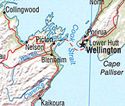
Cook Strait
Encyclopedia
Strait
A strait or straits is a narrow, typically navigable channel of water that connects two larger, navigable bodies of water. It most commonly refers to a channel of water that lies between two land masses, but it may also refer to a navigable channel through a body of water that is otherwise not...
between the North
North Island
The North Island is one of the two main islands of New Zealand, separated from the much less populous South Island by Cook Strait. The island is in area, making it the world's 14th-largest island...
and South Island
South Island
The South Island is the larger of the two major islands of New Zealand, the other being the more populous North Island. It is bordered to the north by Cook Strait, to the west by the Tasman Sea, to the south and east by the Pacific Ocean...
s of New Zealand
New Zealand
New Zealand is an island country in the south-western Pacific Ocean comprising two main landmasses and numerous smaller islands. The country is situated some east of Australia across the Tasman Sea, and roughly south of the Pacific island nations of New Caledonia, Fiji, and Tonga...
. It connects the Tasman Sea
Tasman Sea
The Tasman Sea is the large body of water between Australia and New Zealand, approximately across. It extends 2,800 km from north to south. It is a south-western segment of the South Pacific Ocean. The sea was named after the Dutch explorer Abel Janszoon Tasman, the first recorded European...
on the west with the South Pacific Ocean on the east.
To the south the coast runs runs 30 kilometres (18.6 mi) along Cloudy Bay
Cloudy Bay
Cloudy Bay is located at the northeast of New Zealand's South Island, to the south of the Marlborough Sounds. The area lends its name to one of the best known New World white wines although the grapes used in production of that wine are grown in the Marlborough wine region further inland.The bay...
and past the islands and entrances to the Marlborough Sounds
Marlborough Sounds
The Marlborough Sounds are an extensive network of sea-drowned valleys created by a combination of land subsidence and rising sea levels at the north of the South Island of New Zealand...
. To the north the coast runs 40 kilometres (24.9 mi) along Palliser Bay
Palliser Bay
Palliser Bay is located at the southern end of the North Island of New Zealand, to the southeast of Wellington. It runs for 40 kilometres along the Cook Strait coast from Turakirae Head at the southern end of the Rimutaka Ranges to Cape Palliser, the North Island's southernmost point.Inland from...
, crosses the entrance to Wellington harbour
Wellington Harbour
Wellington Harbour is the large natural harbour at the southern tip of New Zealand's North Island. New Zealand's capital, Wellington, is on the western side of Wellington Harbour. The harbour was officially named Port Nicholson until it assumed its current name in the 1980s.In Māori the harbour is...
, past some Wellington suburbs and continues another 15 kilometres (9.3 mi) to Makara beach
Makara, New Zealand
Makara is a locality located at the western edge of Wellington, New Zealand, close to the shore of the Tasman Sea.With road access over passes from either Karori or Johnsonville/Ohariu, Makara is a rural area with sparse development....
.
The strait is named after James Cook
James Cook
Captain James Cook, FRS, RN was a British explorer, navigator and cartographer who ultimately rose to the rank of captain in the Royal Navy...
, the first Europe
Europe
Europe is, by convention, one of the world's seven continents. Comprising the westernmost peninsula of Eurasia, Europe is generally 'divided' from Asia to its east by the watershed divides of the Ural and Caucasus Mountains, the Ural River, the Caspian and Black Seas, and the waterways connecting...
an commander to sail through it, in 1770. In Māori
Maori language
Māori or te reo Māori , commonly te reo , is the language of the indigenous population of New Zealand, the Māori. It has the status of an official language in New Zealand...
it has the name Raukawa or Raukawa Moana. Raukawa may mean "bitter leaves".
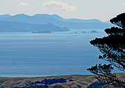
Cook Strait is one of the most dangerous and unpredictable waters in the world. In good weather one can see clearly across the strait. At its narrowest point 22 kilometres (13.7 mi) separate Cape Terawhiti
Cape Terawhiti
Cape Terawhiti is the southwesternmost point of the North Island of New Zealand.The cape is located 16 kilometres to the west of Wellington, the capital city of New Zealand...
in the North Island from Perano Head on Arapawa Island
Arapawa Island
Arapawa Island is a small island located in the Marlborough Sounds, at the north east tip of the South Island of New Zealand.The island has a land area of...
in the Marlborough Sounds
Marlborough Sounds
The Marlborough Sounds are an extensive network of sea-drowned valleys created by a combination of land subsidence and rising sea levels at the north of the South Island of New Zealand...
. Perano Head (South Island) actually lies further north than Cape Terawhiti (North Island).
History
In Māori legend
Maori mythology
Māori mythology and Māori traditions are the two major categories into which the legends of the Māori of New Zealand may usefully be divided...
, Cook Strait was discovered by Kupe
Kupe
In the Māori mythology of some tribes, Kupe was involved in the Polynesian discovery of New Zealand.-Contention:There is contention concerning the status of Kupe. The contention turns on the authenticity of later versions of the legends, the so-called 'orthodox' versions closely associated with S....
the navigator. Kupe followed in his canoe a monstrous octopus called Te Wheke-a-Muturangi
Te Wheke-a-Muturangi
In Māori mythology, Te Wheke-a-Muturangi is a monstrous octopus destroyed in Tory Channel or at Pātea by Kupe the navigator.The octopus was a pet or familiar of Muturangi a powerful tohunga of Hawaiki. The wheke was nonetheless a wild creature and a guardian....
across Cook Strait and destroyed it in Tory Channel
Tory Channel
Tory Channel is one of the drowned valleys that form the Marlborough Sounds in New Zealand.Tory Channel is named after the "Tory", a pioneer ship that brought British colonists to Wellington in 1840. It lies to the south of Arapawa Island, separating it from the mainland. At its western end it...
or at Pātea.
When Dutch explorer Abel Tasman
Abel Tasman
Abel Janszoon Tasman was a Dutch seafarer, explorer, and merchant, best known for his voyages of 1642 and 1644 in the service of the VOC . His was the first known European expedition to reach the islands of Van Diemen's Land and New Zealand and to sight the Fiji islands...
first saw New Zealand in 1642, he thought Cook Strait was a bight
Bight (geography)
In geography, bight has two meanings. A bight can be simply a bend or curve in any geographical feature—usually a bend or curve in the line between land and water....
closed to the east. He named it Zeehaen's Bight, after the Zeehaen, one of the two ships in his expedition. In 1769 James Cook established that it was a strait
Strait
A strait or straits is a narrow, typically navigable channel of water that connects two larger, navigable bodies of water. It most commonly refers to a channel of water that lies between two land masses, but it may also refer to a navigable channel through a body of water that is otherwise not...
, which formed a navigable waterway.
Cook Strait attracted European settlers in the early 19th century. Because of its use as a whale
Whale
Whale is the common name for various marine mammals of the order Cetacea. The term whale sometimes refers to all cetaceans, but more often it excludes dolphins and porpoises, which belong to suborder Odontoceti . This suborder also includes the sperm whale, killer whale, pilot whale, and beluga...
migration route, whaler
Whaler
A whaler is a specialized ship, designed for whaling, the catching and/or processing of whales. The former included the whale catcher, a steam or diesel-driven vessel with a harpoon gun mounted at its bows. The latter included such vessels as the sail or steam-driven whaleship of the 16th to early...
s established bases in the Marlborough Sounds
Marlborough Sounds
The Marlborough Sounds are an extensive network of sea-drowned valleys created by a combination of land subsidence and rising sea levels at the north of the South Island of New Zealand...
and in the Kapiti
Kapiti Coast
The Kapiti Coast is the name of the section of the coast of the south-western North Island of New Zealand that is north of Wellington and opposite Kapiti Island. It falls under the jurisdiction of the Wellington Regional Council...
area. From the late 1820s until the mid 1960s Arapawa Island
Arapawa Island
Arapawa Island is a small island located in the Marlborough Sounds, at the north east tip of the South Island of New Zealand.The island has a land area of...
was a base for whaling in the Sounds. Perano Head on the east coast of the island was the principal whaling station for the area. The houses built by the Perano family are now operated as tourist accommodation.
During the 1820s Te Rauparaha
Te Rauparaha
Te Rauparaha was a Māori rangatira and war leader of the Ngāti Toa tribe who took a leading part in the Musket Wars. He was influential in the original sale of conquered Rangitane land to the New Zealand Company and was a participant in the Wairau Incident in Marlborough...
lead a Māori migration to, and the conquest and settlement of, the Cook Strait region.
From 1840 more permanent settlements sprang up, first at Wellington, then at Nelson
Nelson, New Zealand
Nelson is a city on the eastern shores of Tasman Bay, and is the economic and cultural centre of the Nelson-Tasman region. Established in 1841, it is the second oldest settled city in New Zealand and the oldest in the South Island....
and at Wanganui
Wanganui
Whanganui , also spelled Wanganui, is an urban area and district on the west coast of the North Island of New Zealand. It is part of the Manawatu-Wanganui region....
(Petre). At this period the settlers saw Cook Strait in a broader sense than today's ferry-oriented New Zealanders: for them the strait stretched from Taranaki to Cape Campbell
Cape Campbell
Cape Campbell , Te Karaka in Māori language, is located in Marlborough, New Zealand, on the northeastern coast of the South Island. It lies at the southern end of Clifford Bay, 15 km northeast of Ward, and 42 km southeast of Blenheim....
, so these early towns all clustered around "Cook Strait" (or "Cook's Strait", in the pre-Geographic Board usage of the times) as the central feature and central waterway of the new colony.
Between 1888 and 1912 a dolphin named Pelorus Jack
Pelorus Jack
Pelorus Jack was a Risso's dolphin that was famous for meeting and escorting ships through a stretch of water in Cook Strait, New Zealand, between 1888 and 1912...
became famous for meeting and escorting ships around the Cook Strait. Pelorus Jack was usually spotted in Admiralty Bay between Cape Francis and Collinet Point, near French Pass
D'Urville Island, New Zealand
D'Urville Island is an island in the Marlborough Sounds along the northern coast of the South Island of New Zealand. It was named after the French explorer Jules Dumont d'Urville. With an area of approximately , it is the eighth-largest island of New Zealand, and has around 52 permanent...
, a channel used by ships travelling between Wellington
Wellington
Wellington is the capital city and third most populous urban area of New Zealand, although it is likely to have surpassed Christchurch due to the exodus following the Canterbury Earthquake. It is at the southwestern tip of the North Island, between Cook Strait and the Rimutaka Range...
and Nelson
Nelson, New Zealand
Nelson is a city on the eastern shores of Tasman Bay, and is the economic and cultural centre of the Nelson-Tasman region. Established in 1841, it is the second oldest settled city in New Zealand and the oldest in the South Island....
. Pelorus Jack is also remembered after he was the subject of a failed assassination attempt. He was later protected by a 1904 New Zealand law.
At times when New Zealand feared invasion, various coastal fortifications
Coastal fortifications of New Zealand
Coastal fortifications were constructed in New Zealand in two main waves. The first wave occurred around 1885 and was a response to fears of an attack by Russia. The second wave occurred during World War II and was due to fears of invasion by the Japanese....
were constructed to defend Cook Strait. During the Second World War, two 9.2 inch (23 cm) gun installations were constructed on Wrights Hill
Wrights Hill Fortress
Wrights Hill Fortress is a counter bombardment coastal artillery battery in the Karori suburb of Wellington, New Zealand. It was built between 1942 and 1947 and is predominantly underground, with numerous tunnels linking the war shelters, gun emplacements, magazines, plotting rooms and engine room...
behind Wellington. These gun could range 18 miles (29 km) across Cook Strait. In addition thirteen 6-inch (15 cm) gun installations were constructed around Wellington, along the Makara coast, and at entrances to the Marlborough Sounds. The remains of most of these fortifications can still be seen.
The Pencarrow Head Lighthouse
Pencarrow Head Lighthouse
Pencarrow Head Lighthouse is a decommissioned Lighthouse at Pencarrow Head in the Wellington Region of the North Island of New Zealand.It was the first permanent lighthouse built in New Zealand and was constructed from sections of cast iron that were shipped from England...
was the first permanent lighthouse built in New Zealand. Its first keeper, Mary Jane Bennett, was the first and only female lighthouse keeper in New Zealand. The light was decommissioned in 1935 when it was replaced by the Baring Head Lighthouse
Baring Head Lighthouse
Baring Head Lighthouse is a Lighthouse at Baring Head in the Wellington Region of the North Island of New Zealand. It is owned and operated by Maritime New Zealand....
.
A number of ships have been wrecked with significant loss of life, such as the Maria in 1851, the City of Dunedin in 1865, the St Vincent in 1869, the Lastingham in 1884, the SS Penguin
SS Penguin
SS Penguin was a New Zealand 824 ton inter-island ferry steamer that sank off Cape Terawhiti near the entrance to Wellington Harbour in poor weather on 12 February 1909, and subsequently exploded as cold sea water flooded into the red-hot boiler room. Of the 105 passengers and crew on board, only...
in 1909 and the Wahine
Wahine disaster
The Wahine disaster occurred on 10 April 1968 when the TEV Wahine, a New Zealand inter-island ferry of the Union Company, foundered on Barrett Reef at the entrance to Wellington Harbour and capsized near Steeple Rock...
in 1968.
Geology

Cloudy Bay
Cloudy Bay is located at the northeast of New Zealand's South Island, to the south of the Marlborough Sounds. The area lends its name to one of the best known New World white wines although the grapes used in production of that wine are grown in the Marlborough wine region further inland.The bay...
, Clifford Bay
Clifford Bay, New Zealand
Clifford Bay is a bay in the northeast of the South Island of New Zealand, in the Marlborough Region. It lies between Cloudy Bay to the northwest, and Cape Campbell, the easternmost point of the South Island...
, and Palliser Bay
Palliser Bay
Palliser Bay is located at the southern end of the North Island of New Zealand, to the southeast of Wellington. It runs for 40 kilometres along the Cook Strait coast from Turakirae Head at the southern end of the Rimutaka Ranges to Cape Palliser, the North Island's southernmost point.Inland from...
shoal gently down to 140 metres, where there is a more or less extensive submarine plateau. The rest of the bottom topography is complex. To the east is the Cook Strait Canyon with steep walls descending eastwards into the bathyal depths of the Hikurangi Trench
Hikurangi Trench
The Hikurangi Trench is a linear deep in the Pacific Ocean off the east coast of the North Island of New Zealand, lying between the southern end of the Cook Strait and the Chatham Rise. Though much shallower, it is the southward continuation of the Kermadec Trench and forms part of the...
. To the north-west lies the Narrows Basin, where water is 300 and 400 metres deep. Fisherman's Rock in the north end of the Narrows Basin rises to within a few metres of low tide, and is marked by waves breaking in rough weather. A relatively shallow submarine valley lies across the northern end of the Marlborough Sounds. The bottom topography is particularly irregular around the coast of the South Island where the presence of islands, underwater rocks, and the entrances to the sounds, create violent eddies. The strait has an average depth of 128 metres (420 feet).
The South and North Islands were joined during the last ice age.
Islands
The Brothers is a group of tiny islands in Cook Strait off the east coast of Arapawa IslandArapawa Island
Arapawa Island is a small island located in the Marlborough Sounds, at the north east tip of the South Island of New Zealand.The island has a land area of...
. North Brother island in this small chain is a sanctuary for the rare Brothers Island tuatara, while the largest of the islands is the site of the Brothers Island Lighthouse.
Tidal flow
The tidal flow through Cook Strait is unusual. On each side of the strait the tide is almost exactly out of phase, so high water on one side meets low water on the other. Strong currents result, with almost zero tidal height change in the centre of the strait. Although the tidal surge should flow in one direction for six hours and then the reverse direction for six hours, a particular surge might last eight or ten hours with the reverse surge enfeebled. In especially boisterous weather conditions the reverse surge can be negated, and the flow can remain in the same direction through three surge periods and longer. This is indicated on marine charts for the region.There are numerous computer model representations of the tidal flow through Cook Strait. While the tidal components are readily realizable, the residual flow is more difficult to model.
Tidal power
In April 2008, a resource consent was granted to Neptune Power for the installation of a $10 million experimental underwater tidal stream turbineTidal stream generator
A tidal stream generator, often referred to as a tidal energy converter is a machine that extracts energy from moving masses of water, in particular tides, although the term is often used in reference to machines designed to extract energy from run of river or tidal estuarine sites...
capable of producing one megawatt. The turbine has been designed in Britain, and will be built in New Zealand. It will be 14 metres in diameter and constructed of carbon fibre. It will be placed in eighty metres of water, 4.5 kilometres due south of Sinclair Head, in waters known as the “Karori rip”. Power from the turbine will be brought ashore at Vector's
Vector Limited
Vector Limited is a multi-network infrastructure company in New Zealand. It is the national number one provider of electricity distribution, number one provider of gas transmission and distribution, number one provider of electricity and gas metering, number two wholesaler of LPG and number three...
Island Bay substation. The turbine is a pilot, and will be sited in slower tides for testing. Neptune hopes to generate power from the unit by 2010. The company claims there is enough tidal movement in Cook Strait to generate 12 GW of power, more than one-and-a-half times New Zealand's current requirements. In practice, only some of this energy could be harnessed.
On the other side of the strait, Energy Pacifica has applied for resource consent to install up to 10 marine turbines, each able to produce up to 1.2 MW, near the Cook Strait entrance to Tory Channel
Tory Channel
Tory Channel is one of the drowned valleys that form the Marlborough Sounds in New Zealand.Tory Channel is named after the "Tory", a pioneer ship that brought British colonists to Wellington in 1840. It lies to the south of Arapawa Island, separating it from the mainland. At its western end it...
. They claim Tory Channel is an optimal site with a tidal current speed of 3.6 metres a second and the best combination of bathymetry
Bathymetry
Bathymetry is the study of underwater depth of lake or ocean floors. In other words, bathymetry is the underwater equivalent to hypsometry. The name comes from Greek βαθύς , "deep", and μέτρον , "measure"...
and accessibility to the electricity network.
The power generated by tidal marine turbines varies as the cube of the tidal speed. Because the tidal speed doubles, eight times more tidal power is produced during spring tides than at neaps.
Cables
Electric-power and communication cables link the North and South Islands across Cook Strait. These cables are currently operated by TranspowerTranspower New Zealand Limited
Transpower New Zealand Limited is the state-owned enterprise responsible for electric power transmission in New Zealand. Transpower performs two major functions in the New Zealand Electricity Market...
.
- Power cables: A high-voltage direct currentHigh-voltage direct currentA high-voltage, direct current electric power transmission system uses direct current for the bulk transmission of electrical power, in contrast with the more common alternating current systems. For long-distance transmission, HVDC systems may be less expensive and suffer lower electrical losses...
(HVDC) system uses three undersea cables. During dry periods, this gives the South Island access to gas and coal power generated in the North Island. Likewise, during peak winter periods, it gives the North Island access to power from the large hydroelectric installations in the South Island. The submarine cables are laid on the seabed within a legally defined zone called the cable protection zone (CPZ). The CPZ is about seven kilometres wide for most of its length. It narrows where the cables enter the water at Fighting Bay on the South Island and at Oteranga Bay, Cape TerawhitiCape TerawhitiCape Terawhiti is the southwesternmost point of the North Island of New Zealand.The cape is located 16 kilometres to the west of Wellington, the capital city of New Zealand...
, in the North Island. Fishing activities and anchoring boats are prohibited within the CPZ. Transpower has a current proposal to spend nearly $700 million upgrading the electricity link. If implemented, this will have a capacity of 1200 MW by 2014.
- Communication cables: Fibre optic cables carry telecommunications across Cook Strait, used by New Zealand’s main telecommunication companies for domestic and commercial traffic and by Transpower for control of the HVDC link.
Marine life
Giant squid specimens have been washed ashore on Cook Strait or found in the stomachs of sperm whales off KaikouraKaikoura
Kaikoura is a town on the east coast of the South Island of New Zealand. It is located on State Highway 1 180 km north of Christchurch.Kaikoura became the first local authority to reach the Green Globe tourism certification standard....
.
A colony of male fur seals has long been established near Red Rocks on the Makara Coast, west of Wellington.
Cook Strait offers important habitats to many cetacean species. Several dolphins (Bottlenose
Bottlenose Dolphin
Bottlenose dolphins, the genus Tursiops, are the most common and well-known members of the family Delphinidae, the family of oceanic dolphins. Recent molecular studies show the genus contains two species, the common bottlenose dolphin and the Indo-Pacific bottlenose dolphin , instead of one...
, Common
Common dolphin
The common dolphin is the name given to two species of dolphin making up the genus Delphinus.Prior to the mid-1990s, most taxonomists only recognised one species in this genus, the common dolphin Delphinus delphis...
, Dusky
Dusky Dolphin
The dusky dolphin is a dolphin found in coastal waters in the Southern Hemisphere. Its specific epithet is Latin for "dark" or "dim". It is very closely genetically related to the Pacific white-sided dolphin, but current scientific consensus is that they are distinct species...
) frequent the area along with Killer Whales and the endemic Hector's Dolphin
Hector's Dolphin
Hector's dolphin is the best-known of the four dolphins in the genus Cephalorhynchus and is found only in New Zealand. At about 1.4 m in length, it is one of the smallest cetaceans....
s. Long-Finned Pilot Whale
Long-finned Pilot Whale
The long-finned pilot whale is one of the two species of cetacean in the genus Globicephala. It belongs to the oceanic dolphin family , though its behavior is closer to that of the larger whales.-Description:...
s often strand en masse at Golden Bay
Golden Bay
Golden Bay lies at the edge of the junction between the Tasman Sea and Cook Strait. It stretches for 45 kilometres from the long sand spit of Farewell Spit in the north to Separation Point in Abel Tasman National Park at its southern extremity...
. The famous Pelorus Jack
Pelorus Jack
Pelorus Jack was a Risso's dolphin that was famous for meeting and escorting ships through a stretch of water in Cook Strait, New Zealand, between 1888 and 1912...
was a Risso's Dolphin
Risso's Dolphin
Risso's dolphin is the only species of dolphin in the genus Grampus.-Taxonomy:Risso's dolphin is named after Antoine Risso, whose description formed the basis of the first public description of the animal, by Georges Cuvier, in 1812...
being observed escorting the ships between 1888 and 1912, though this species is not a common visitor to the New Zealand's waters.
Migratory large whales attracted many whaler
Whaler
A whaler is a specialized ship, designed for whaling, the catching and/or processing of whales. The former included the whale catcher, a steam or diesel-driven vessel with a harpoon gun mounted at its bows. The latter included such vessels as the sail or steam-driven whaleship of the 16th to early...
s to the area in the winter. Currently, an annual survey of counting Humpback Whale
Humpback Whale
The humpback whale is a species of baleen whale. One of the larger rorqual species, adults range in length from and weigh approximately . The humpback has a distinctive body shape, with unusually long pectoral fins and a knobbly head. It is an acrobatic animal, often breaching and slapping the...
s is taken by Department of Conservation and former whalers help DOC to spot animals. Other occasional visitors include Southern Right Whale
Southern Right Whale
The southern right whale is a baleen whale, one of three species classified as right whales belonging to the genus Eubalaena. Like other right whales, the southern right whale is readily distinguished from others by the callosities on its head, a broad back without a dorsal fin, and a long arching...
s, Blue Whale
Blue Whale
The blue whale is a marine mammal belonging to the suborder of baleen whales . At in length and or more in weight, it is the largest known animal to have ever existed....
s, Sei Whale
Sei Whale
The sei whale , Balaenoptera borealis, is a baleen whale, the third-largest rorqual after the blue whale and the fin whale. It inhabits most oceans and adjoining seas, and prefers deep offshore waters. It avoids polar and tropical waters and semi-enclosed bodies of water...
s and Sperm Whale
Sperm Whale
The sperm whale, Physeter macrocephalus, is a marine mammal species, order Cetacea, a toothed whale having the largest brain of any animal. The name comes from the milky-white waxy substance, spermaceti, found in the animal's head. The sperm whale is the only living member of genus Physeter...
s.
Game fishing
Cook Strait offers good game fishingBig-game fishing
Big-game fishing, often referred to as offshore sportfishing, offshore gamefishing, or blue-water fishing is a form of recreational fishing, targeting large fish renowned for their sporting qualities, such as tuna and marlin.-History:...
. Albacore tuna can be caught from January to May. Broadbill swordfish
Swordfish
Swordfish , also known as broadbill in some countries, are large, highly migratory, predatory fish characterized by a long, flat bill. They are a popular sport fish of the billfish category, though elusive. Swordfish are elongated, round-bodied, and lose all teeth and scales by adulthood...
, bluenose, mako sharks
Isurus
Isurus is a genus of mackerel sharks in the family Lamnidae, commonly known as the mako sharks. There are two living species, the common shortfin mako shark and the rare longfin mako shark , and several extinct species known from fossils. They range in length from 9 to 15 feet, and have an...
and the occasional marlin
Marlin
Marlin, family Istiophoridae, are fish with an elongated body, a spear-like snout or bill, and a long rigid dorsal fin, which extends forward to form a crest. Its common name is thought to derive from its resemblance to a sailor's marlinspike...
and white shark can also be caught.
Transport
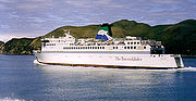
Ferry
Regular ferryFerry
A ferry is a form of transportation, usually a boat, but sometimes a ship, used to carry primarily passengers, and sometimes vehicles and cargo as well, across a body of water. Most ferries operate on regular, frequent, return services...
services run between Picton
Picton, New Zealand
Picton is a town in the Marlborough region of New Zealand. It is close to the head of Queen Charlotte Sound near the north-east corner of the South Island. The population was 2928 in the 2006 Census, a decrease of 72 from 2001...
in the Sounds and Wellington
Wellington
Wellington is the capital city and third most populous urban area of New Zealand, although it is likely to have surpassed Christchurch due to the exodus following the Canterbury Earthquake. It is at the southwestern tip of the North Island, between Cook Strait and the Rimutaka Range...
. Although Cook Strait is only 24 kilometres wide at its narrowest point, the ferry journey covers 70 kilometres. The strait
Strait
A strait or straits is a narrow, typically navigable channel of water that connects two larger, navigable bodies of water. It most commonly refers to a channel of water that lies between two land masses, but it may also refer to a navigable channel through a body of water that is otherwise not...
often experiences rough water and heavy swells from strong winds, especially from the south. New Zealand's position directly athwart the roaring forties
Roaring Forties
The Roaring Forties is the name given to strong westerly winds found in the Southern Hemisphere, generally between the latitudes of 40 and 49 degrees. Air displaced from the Equator towards the South Pole, which travels close to the surface between the latitudes of 30 and 60 degrees south, combines...
means that the strait funnels westerly winds and deflects them into northerlies. Due to this the Cook Strait is regarded as one of the most dangerous and unpredictable waters in the world.
Swimming
According to oral traditionMaori mythology
Māori mythology and Māori traditions are the two major categories into which the legends of the Māori of New Zealand may usefully be divided...
, the first woman to swim Cook Strait was Hine Poupou. She swam from Kapiti Island
Kapiti Island
-External links:* , Department of Conservation* * , Nature Coast Enterprise *...
to Dürville Island with the help of a dolphin. Other Māori accounts tell of at least one swimmer who conquered the strait in 1831.
In modern times, the strait was first swum by Barrie Devenport
Barrie Devenport
Barrie Devenport was a New Zealand swimmer and lifesaver who was the first person in modern history to swim Cook Strait....
in 1962. Lynne Cox
Lynne Cox
Lynne Cox is an American long-distance open-water swimmer and writer. In 1971, she and her teammates were the first group of teenagers to complete the crossing of the Catalina Island Channel in California. She was always the slowest swimmer in her swim classes...
was the first woman to swim it, in 1975. The most prolific swimmer of the strait is Philip Rush
Philip Rush
Philip Rush is a firefighter and long distance swimmer who is the current world record holder for the fastest two and three way swim of the English Channel which he completed in 1987 in a time of 28 h 21 mins -Biography:To date...
, who has crossed eight times, including two double crossings. Aditya Raut
Aditya Raut
Aditya Raut is a record breaking long distance swimmer. He is barely 14 year as on 2007 and has a distinction of swimming across the five continental channels and is the youngest in the world do so and only third Indian to accomplish it. He many holds world records for swimming. He was born to...
was the youngest swimmer at 11 years. Stephanie Bennington was the youngest female swimmer at 13 years. Pam Dickson was the oldest swimmer at 55 years.
By 2010, 74 single crossings had been made by 65 individuals, and three double crossings had been made by two individuals (Philip Rush and Meda McKenzie). Crossing times are largely determined by the strong and sometimes unpredictable currents that operate in the strait.
Timeline
- Mists of time: The mythical navigator KupeKupeIn the Māori mythology of some tribes, Kupe was involved in the Polynesian discovery of New Zealand.-Contention:There is contention concerning the status of Kupe. The contention turns on the authenticity of later versions of the legends, the so-called 'orthodox' versions closely associated with S....
follows, in his canoe, the octopus Te Wheke-a-MuturangiTe Wheke-a-MuturangiIn Māori mythology, Te Wheke-a-Muturangi is a monstrous octopus destroyed in Tory Channel or at Pātea by Kupe the navigator.The octopus was a pet or familiar of Muturangi a powerful tohunga of Hawaiki. The wheke was nonetheless a wild creature and a guardian....
across Cook Strait. - 1642: Abel TasmanAbel TasmanAbel Janszoon Tasman was a Dutch seafarer, explorer, and merchant, best known for his voyages of 1642 and 1644 in the service of the VOC . His was the first known European expedition to reach the islands of Van Diemen's Land and New Zealand and to sight the Fiji islands...
mistakes Cook Strait for a bightBight (geography)In geography, bight has two meanings. A bight can be simply a bend or curve in any geographical feature—usually a bend or curve in the line between land and water....
. - 1769: James CookJames CookCaptain James Cook, FRS, RN was a British explorer, navigator and cartographer who ultimately rose to the rank of captain in the Royal Navy...
establishes it is a straitStraitA strait or straits is a narrow, typically navigable channel of water that connects two larger, navigable bodies of water. It most commonly refers to a channel of water that lies between two land masses, but it may also refer to a navigable channel through a body of water that is otherwise not... - 1822: Ngati ToaNgati ToaNgāti Toa , an iwi , traces its descent from the eponymous ancestor Toarangatira. The Ngāti Toa region extends from Miria-te-kakara at Rangitikei to Wellington, and across Cook Strait to Wairau and Nelson....
migrates to Cook Strait region, led by Te RauparahaTe RauparahaTe Rauparaha was a Māori rangatira and war leader of the Ngāti Toa tribe who took a leading part in the Musket Wars. He was influential in the original sale of conquered Rangitane land to the New Zealand Company and was a participant in the Wairau Incident in Marlborough...
. - 1831: Whaling station established in Tory ChannelTory ChannelTory Channel is one of the drowned valleys that form the Marlborough Sounds in New Zealand.Tory Channel is named after the "Tory", a pioneer ship that brought British colonists to Wellington in 1840. It lies to the south of Arapawa Island, separating it from the mainland. At its western end it...
. - 1851: Maria wrecked in on rocks at Cape TerawhitiCape TerawhitiCape Terawhiti is the southwesternmost point of the North Island of New Zealand.The cape is located 16 kilometres to the west of Wellington, the capital city of New Zealand...
, 26 people die. - 1855: Severe earthquake on both sides of Cook Strait.
- 1865: Paddle steamer City of Dunedin sinks in Cook Strait, 39 people die.
- 1866: Cook Strait submarine telegraph cable laid.
- 1869: St Vincent wrecked in Palliser BayPalliser BayPalliser Bay is located at the southern end of the North Island of New Zealand, to the southeast of Wellington. It runs for 40 kilometres along the Cook Strait coast from Turakirae Head at the southern end of the Rimutaka Ranges to Cape Palliser, the North Island's southernmost point.Inland from...
, 20 people die. - 1879: Kangaroo lays the first Telegraph cable across Cook Strait.
- 1884: Lastingham wrecked at Cape JacksonCape Jackson, New ZealandCape Jackson is a peninsula in Marlborough, in the South Island of New Zealand. It lies between Queen Charlotte Sound and Cook Strait.Cape Jackson's history involves gold mining, sheep farming, and more recently carbon farming .Cape Jackson is privately owned...
, 18 people die. - 1904: Pelorus JackPelorus JackPelorus Jack was a Risso's dolphin that was famous for meeting and escorting ships through a stretch of water in Cook Strait, New Zealand, between 1888 and 1912...
is protected by New Zealand law - 1909: SS PenguinSS PenguinSS Penguin was a New Zealand 824 ton inter-island ferry steamer that sank off Cape Terawhiti near the entrance to Wellington Harbour in poor weather on 12 February 1909, and subsequently exploded as cold sea water flooded into the red-hot boiler room. Of the 105 passengers and crew on board, only...
wrecked in Cook Strait, 75 people die. - 1920: First aeroplane flight across Cook Strait.
- 1935: Air services begin across Cook Strait.
- 1962: Cook Strait rail ferry service begins.
- 1962: Barrie DevenportBarrie DevenportBarrie Devenport was a New Zealand swimmer and lifesaver who was the first person in modern history to swim Cook Strait....
swims the strait. - 1964: Cook Strait power cables laid.
- 1968: TEV WahineWahine disasterThe Wahine disaster occurred on 10 April 1968 when the TEV Wahine, a New Zealand inter-island ferry of the Union Company, foundered on Barrett Reef at the entrance to Wellington Harbour and capsized near Steeple Rock...
wrecked at entrance to Wellington harbour, 53 people die. - 1975: Lynne CoxLynne CoxLynne Cox is an American long-distance open-water swimmer and writer. In 1971, she and her teammates were the first group of teenagers to complete the crossing of the Catalina Island Channel in California. She was always the slowest swimmer in her swim classes...
is the first woman to swim the strait. - 1979: Paul CaffynPaul CaffynPaul Caffyn is a well renowned sea kayaker based on the west coast of New Zealand. He has completed a number of supported, unsupported, solo and group expeditions by sea kayak in various locations around the world...
crosses the strait in a sea kayakSea kayakA sea kayak or touring kayak is a kayak developed for the sport of paddling on open waters of lakes, bays, and the ocean. Sea kayaks are seaworthy small boats with a covered deck and the ability to incorporate a spraydeck...
. - 1984: Philip RushPhilip RushPhilip Rush is a firefighter and long distance swimmer who is the current world record holder for the fastest two and three way swim of the English Channel which he completed in 1987 in a time of 28 h 21 mins -Biography:To date...
swims the strait both ways (13 March). - 1984: Meda McKenzie swims the strait both ways (26 March).
- 1988: Philip RushPhilip RushPhilip Rush is a firefighter and long distance swimmer who is the current world record holder for the fastest two and three way swim of the English Channel which he completed in 1987 in a time of 28 h 21 mins -Biography:To date...
swims the strait both ways (9 February). - 1991: Five new power and communication cables laid
- 1994: First fast-ferry service begins operation across Cook Strait.
- 2002: Two further communications cables laid.
- 2005: The retired frigate HMNZS Wellington is sunk off Wellington as an artificial reef.
- 2008: A resource consent is granted to Neptune Power to install a $10 million experimental underwater tidal stream turbine capable of producing one megawatt.
- 2008: Energy Pacifica applies for resource consent to install up to 10 marine turbines, each able to produce up to 1.2 MW, near the Cook Strait entrance to Tory Channel.
External links
- Cook Strait: Ship Wrecks, Swells and Gales
- New Zealand's Cook Strait Rail Ferries
- Cook Strait Swim
- NZ: Chance to turn the tide of power supply EnergyBulletin.net
- Lewis, Keith Submarine cables Te Ara - the Encyclopedia of New Zealand, updated 21-Sep-2007.
- History of Cable Bay Station
- A Powerful link: The Cook Strait Cable
- NZ Documentary Film (2007) Fish & Ships The Island Bay fishing fleet.