
Clutha River
Encyclopedia
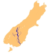
The Clutha River / Mata-Au is the second longest river
in New Zealand
flowing south-southeast 338 kilometres (210 mi) through Central
and South Otago
from Lake Wanaka
in the Southern Alps
to the Pacific Ocean
, 75 kilometres (46.6 mi) south west of Dunedin
. It is the highest volume river in New Zealand, and the swiftest, with a catchment of 21960 square kilometres (8,478.8 sq mi), discharging a mean flow of 614 m3/s. The Clutha River is known for its scenery, gold-rush history, and swift turquoise waters. A river conservation group, the Clutha Mata-Au River Parkway Group
, is working to establish a regional river parkway, with a trail, along the entire river corridor. The name of the river was changed to a dual name by the Ngai Tahu Claims Settlement Act 1998.
 The ultimate source of the river is at the head of the Makarora River
, close to the saddle of the Haast Pass
, which flows into the northern end of Lake Wanaka
. The southern end of the lake drains into the nascent Clutha close to Albert Town
, where it is met by its first main tributary, the Hawea River
the outflow of Lake Wanaka's twin, Lake Hawea
. It is also met here by the Cardrona River
.
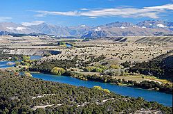
From here the river flows swiftly through the Upper Clutha Valley between ancient glacial terraces, negotiating a long section called the 'Snake' before reaching a rare switchback feature called the Devil's Nook near the town of Luggate
. The river soon narrows as it passes through the Maori Gorge at Queensberry. Shortly thereafter it is joined by another tributary, the Lindis
, before widening as it enters Lake Dunstan
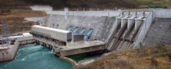
, an artificial lake created behind the massive hydroelectric
dam at Clyde.
Fifty kilometres south of Lake Wanaka, the Clutha reaches the town of Cromwell
, which was substantially altered when the Clyde Dam
project was commissioned in 1992. Here the river is joined by the waters of the Kawarau
, which flows from Lake Wakatipu
. Prior to the construction of the Clyde Dam, this river junction, known as the Cromwell Junction , was renowned for the difference in colour between the two rivers’ waters.
The river then flows southeast through the inundated Cromwell Gorge
to Clyde
, and nearby Alexandra
, where it is joined by the waters of the Manuherikia River
. South of Alexandra the river widens again to form Lake Roxburgh
, another artificial lake, behind the Roxburgh Dam
, which was commissioned in 1956. The hydro reservoir flooded the Roxburgh Gorge and several large rapids including the Molyneux Falls and the Golden Falls. The town of Roxburgh
sits close to the river, 120 kilometres (74.6 mi) downstream from Lake Wanaka.
From here the river continues southeast past the towns of Ettrick
, Millers Flat
, and Beaumont
, before flowing through the Rongahere Gorge admired for its native bush corridor and for the Birch Island native reserve. Beyond here, the river is met by the Tuapeka River
at Tuapeka Mouth. At this point the river turns southward, before being met by its last major tributary, the Pomahaka River
, which joins the Clutha 30 kilometres (18.6 mi) from the coast. The river passes the town of Balclutha
before widening into the Clutha delta which contains the large flat island of Inch Clutha
. Here the river divides into two branches, the Matau (northern), which flows past Kaitangata
, and Koau (southern). Both branches flow into the Pacific Ocean at Molyneux Bay.
The Clutha's average discharge is estimated at 614 m3/s, comparable to many much larger rivers. This heavy flow, combined with the relatively small size of the river in global terms, makes the Clutha notoriously fast-flowing, and it is often listed as one of the world's most swiftly flowing rivers, alongside Australia's Macleay
and Fitzroy River
s, the Amazon
and Atrato River
s in South America, and the Teesta River
in the Himalaya.
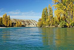
The waters of the Upper Clutha are clear turquoise, the result of glacial and snow-melt filtering when the water flows through Lake Wanaka. This is a rare characteristic for a high volume river. Below Cromwell, where the silt-laden Kawarau
enters, the waters are less turquoise.
, Taieri
, Waikouaiti
, Shag
, and even the Waitaki
.
, predated upon by the Haast's Eagle
. The river was known by the Māori as Mata-au, meaning current or eddy in an expanse of water. This name, now more frequently rendered as Matau, is still used for one of the two main channels of the Clutha delta. In the early days of European exploration there was at least one settlement of some 250-300 Māori close to the river's banks. The river takes its European name from Cluaidh, the Scots Gaelic name for the River Clyde
in Scotland
which runs through Glasgow
. During New Zealand's early colonial history it was known as the Molyneux, that name given to it by Captain Cook
. During early European settlement, a whaling station was established close to the river's mouth, and during this period the sea was the source of almost all of the area's economy.
deposits in Otago were discovered around the Tuapeka River
at Gabriel's Gully
by Gabriel Read
in 1861, and the following year large amounts of the precious metal were discovered close to the site of modern Cromwell
.
By Christmas
1861, 14,000 prospectors were on the Tuapeka and Waipori fields. The gold rush was short-lived, with most of the alluvial gold played out by 1863, but prospectors continued to arrive, swelling to a maximum of 18,000 miners in February 1864.
 Several major flood
s have occurred on the Clutha, most notably the “Hundred year floods” of 14–16 October 1878 and 13–15 October 1978. The 1878 flood is regarded as New Zealand's greatest known flood. During this, a bridge at Clydevale was washed downstream, where it collided with the Balclutha Road Bridge, destroying the latter.
The 1978 flood, in which rivers from the Oreti
in the south to the Tokomairiro
in the north breached their banks, led to the inundation of over 12000 hectares (29,652.6 acre) of land and the loss of over 21,000 livestock. Towns and areas affected stretched from Makarora
in the north to Invercargill
in the south. The town of Wyndham
was completely evacuated, and the towns of Balclutha
, Milton
and Mataura
were seriously affected with many residents moved. The small settlement of Kelso
on the banks of the Pomahaka River
was completely abandoned and was not rebuilt once the waters subsided. At its peak, at 6.00 a.m. on the 15th, the Clutha's flow was measured at just over 4500 m3/s.
A major flood in 1999 caused serious damage to river communities, especially Alexandra
. The flooding in Alexandra was attributed to a rise in the riverbed, resulting from silt loading in the Roxburgh reservoir behind the Roxburgh Dam
downriver from the town. The 1878 flood had not flooded the town, but the 1999 did, despite being only 80% of the volume of the 1878 flood. http://www.alexfloods.org.nz.
and the Roxburgh Dam
, located on the river providing electricity to the New Zealand power grid.
 The Clutha also provides irrigation for stone fruit orchards around Cromwell, Alexandra, and Roxburgh, which provide apple
s, apricot
s, nectarines, cherries
, and peach
es. Several small vineyards
are also found in the upper reaches of the river.
The spectacular scenery of Central Otago makes the upper Clutha a popular holiday destination, especially for adventure tourism. Jetboat
ing, kayaking
, rafting
, riverboarding
, and guided fishing
occurs on the river, and waterskiing, tandem parachuting
and parapenting operators are all to be found in the area. The upper Clutha is also used for multi-sports events, and Lake Dunstan is an important rowing
venue. Several major ski courses
are found close to the river. Curling
is also played close to the Clutha in the harsh Central Otago winters.
River
A river is a natural watercourse, usually freshwater, flowing towards an ocean, a lake, a sea, or another river. In a few cases, a river simply flows into the ground or dries up completely before reaching another body of water. Small rivers may also be called by several other names, including...
in New Zealand
New Zealand
New Zealand is an island country in the south-western Pacific Ocean comprising two main landmasses and numerous smaller islands. The country is situated some east of Australia across the Tasman Sea, and roughly south of the Pacific island nations of New Caledonia, Fiji, and Tonga...
flowing south-southeast 338 kilometres (210 mi) through Central
Central Otago
Central Otago is the inland part of the New Zealand region of Otago in the South Island. The area commonly known as Central Otago includes both the Central Otago District and the Queenstown-Lakes District to the west....
and South Otago
South Otago
South Otago lies in the south east of the South Island of New Zealand. As the name suggests, it forms the southernmost part of the geographical region of Otago....
from Lake Wanaka
Lake Wanaka
Lake Wanaka is located in the Otago region of New Zealand, at an altitude of 300 metres. Covering an area of , it is New Zealand's fourth largest lake, and estimated to be more than deep...
in the Southern Alps
Southern Alps
The Southern Alps is a mountain range extending along much of the length of New Zealand's South Island, reaching its greatest elevations near the island's western side...
to the Pacific Ocean
Pacific Ocean
The Pacific Ocean is the largest of the Earth's oceanic divisions. It extends from the Arctic in the north to the Southern Ocean in the south, bounded by Asia and Australia in the west, and the Americas in the east.At 165.2 million square kilometres in area, this largest division of the World...
, 75 kilometres (46.6 mi) south west of Dunedin
Dunedin
Dunedin is the second-largest city in the South Island of New Zealand, and the principal city of the Otago Region. It is considered to be one of the four main urban centres of New Zealand for historic, cultural, and geographic reasons. Dunedin was the largest city by territorial land area until...
. It is the highest volume river in New Zealand, and the swiftest, with a catchment of 21960 square kilometres (8,478.8 sq mi), discharging a mean flow of 614 m3/s. The Clutha River is known for its scenery, gold-rush history, and swift turquoise waters. A river conservation group, the Clutha Mata-Au River Parkway Group
Clutha Mata-Au River Parkway Group
The Clutha Mata-Au River Parkway Group, New Zealand, was formed in October 2003, and is an Incorporated Society, with Charitable and Donee Status. The Group was set up in response to land development issues along the Clutha Mata-Au River corridor, much of which has high scenic and recreational values...
, is working to establish a regional river parkway, with a trail, along the entire river corridor. The name of the river was changed to a dual name by the Ngai Tahu Claims Settlement Act 1998.
Geography
Makarora River
-Geography:The headwaters are in Mount Aspiring National Park, on the eastern flanks of the Southern Alps near Haast Pass, which is the saddle between the Makarora and Haast River valleys. The Makarora flows south into the northern end of Lake Wanaka after passing the small community of Makarora...
, close to the saddle of the Haast Pass
Haast Pass
Haast Pass is a mountain pass in the Southern Alps of the South Island of New Zealand. It is named for Julius von Haast, a 19th century explorer who was also geologist for the Provincial government of Canterbury...
, which flows into the northern end of Lake Wanaka
Lake Wanaka
Lake Wanaka is located in the Otago region of New Zealand, at an altitude of 300 metres. Covering an area of , it is New Zealand's fourth largest lake, and estimated to be more than deep...
. The southern end of the lake drains into the nascent Clutha close to Albert Town
Albert Town, New Zealand
Albert Town is located to the east of Wanaka in Otago, New Zealand. Until recently only a farming settlement, the population boom in this area has led to much new development. The confluence of the Clutha and Cardrona Rivers is located here. The town was named after Prince Albert of Saxe-Coburg and...
, where it is met by its first main tributary, the Hawea River
Hawea River
The Hawea River is a river of New Zealand, draining Lake Hawea into the Clutha River.-References:...
the outflow of Lake Wanaka's twin, Lake Hawea
Lake Hawea
Lake Hawea is located in the Otago Region of New Zealand, at an altitude of 348 metres. It covers an area of some 141 km² and is, at its deepest, 392 metres deep...
. It is also met here by the Cardrona River
Cardrona River
The Cardrona River is found in Otago in the South Island of New Zealand. It is one of the first tributaries of the Clutha River, which it meets only five kilometres from the latter's origin at the outflow of Lake Wanaka....
.
From here the river flows swiftly through the Upper Clutha Valley between ancient glacial terraces, negotiating a long section called the 'Snake' before reaching a rare switchback feature called the Devil's Nook near the town of Luggate
Luggate
Luggate is a small township in the South Island of New Zealand. It is located on State Highway 6 between Wanaka and Cromwell, near the junction with State Highway 8A, approximately 15 km from the Wanaka township, just past Wanaka Airport....
. The river soon narrows as it passes through the Maori Gorge at Queensberry. Shortly thereafter it is joined by another tributary, the Lindis
Lindis River
The Lindis River is found in Otago in the South Island of New Zealand. It is a tributary of the Clutha River, flowing south for 55 kilometres through the Lindis Pass, site of the main inland road route between Otago and the Mackenzie Basin in Canterbury....
, before widening as it enters Lake Dunstan
Lake Dunstan
Lake Dunstan is a man-made lake and reservoir in the South Island of New Zealand.The lake was formed on the Clutha River as a result of the construction of the Clyde Dam, filling in four controlled stages beginning in April 1992 and completed the next year...
, an artificial lake created behind the massive hydroelectric
Hydroelectricity
Hydroelectricity is the term referring to electricity generated by hydropower; the production of electrical power through the use of the gravitational force of falling or flowing water. It is the most widely used form of renewable energy...
dam at Clyde.
Fifty kilometres south of Lake Wanaka, the Clutha reaches the town of Cromwell
Cromwell, New Zealand
Cromwell is a town in Central Otago in the Otago region of New Zealand.It is situated between State Highway 6 and State Highway 8 leading to the Lindis Pass, 75 km northeast, and Alexandra, 33 km south. The road to Alexandra winds through the Cromwell Gorge...
, which was substantially altered when the Clyde Dam
Clyde Dam
The Clyde Dam, New Zealand's third largest hydroelectric dam, is built on the Clutha River near the town of Clyde. It is owned and operated by Contact Energy.-History:...
project was commissioned in 1992. Here the river is joined by the waters of the Kawarau
Kawarau River
Kawarau River drains Lake Wakatipu, in northwestern Otago, New Zealand. The river flows generally eastwards for about 60 km and passes through the steep Kawarau Gorge until it joins Lake Dunstan near Cromwell. The Shotover River enters it from the north; the Nevis River enters it from the south...
, which flows from Lake Wakatipu
Lake Wakatipu
Lake Wakatipu is an inland lake in the South Island of New Zealand. It is in the southwest corner of Otago Region, near its boundary with Southland.With a length of , it is New Zealand's longest lake, and, at , its third largest...
. Prior to the construction of the Clyde Dam, this river junction, known as the Cromwell Junction , was renowned for the difference in colour between the two rivers’ waters.
The river then flows southeast through the inundated Cromwell Gorge
Cromwell Gorge
The Cromwell Gorge is a deep gorge on the Clutha River in the Otago region of New Zealand's South Island. It stretches for 20 km south of the town of Cromwell towards Alexandra....
to Clyde
Clyde, New Zealand
Clyde is a small town in Central Otago, New Zealand with a population of 918 in 2006. It is located on the Clutha River, between Cromwell and Alexandra....
, and nearby Alexandra
Alexandra, New Zealand
Alexandra is a town in the Central Otago district of the Otago region of New Zealand. It is located on the banks of the Clutha River , on State Highway 8, 188 km by road from Dunedin and 33 km south of Cromwell.At the time of the 2006 census, the permanent population was 4,827, an...
, where it is joined by the waters of the Manuherikia River
Manuherikia River
The Manuherikia River is located in Otago in the South Island of New Zealand. It rises in the far north of the Maniototo, flowing southwest for 85 kilometres before its confluence with the Clutha River at Alexandra. During the 1860s the Manuherikia was one of the centres of the Central Otago Gold...
. South of Alexandra the river widens again to form Lake Roxburgh
Lake Roxburgh
Lake Roxburgh is an artificial lake, created by the Roxburgh Dam, the earliest of the large hydroelectric projects in the southern South Island of New Zealand. It lies on the Clutha River, some 160 kilometres from Dunedin. It covers an area of some 6 km², and extends for nearly 30 kilometres...
, another artificial lake, behind the Roxburgh Dam
Roxburgh Dam
The Roxburgh Dam is the earliest of the large hydroelectric projects in the southern South Island of New Zealand. It lies across the Clutha River / Mata-Au, some from Dunedin, some to the north of the town of Roxburgh...
, which was commissioned in 1956. The hydro reservoir flooded the Roxburgh Gorge and several large rapids including the Molyneux Falls and the Golden Falls. The town of Roxburgh
Roxburgh, New Zealand
Roxburgh is a small New Zealand town of about 600 people in Central Otago. It is in Teviot Valley on the banks of the Clutha River, 40 km south of Alexandra in the South Island. State Highway 8, which links Central Otago with Dunedin city, passes through the town...
sits close to the river, 120 kilometres (74.6 mi) downstream from Lake Wanaka.
From here the river continues southeast past the towns of Ettrick
Ettrick, New Zealand
Ettrick is a small town in inland Otago, in the South Island of New Zealand.-Geography:Ettrick is located on the Clutha River and State Highway 8 south of Roxburgh and five kilometres northwest of the small settlement of Millers Flat...
, Millers Flat
Millers Flat, New Zealand
Millers Flat is a small town in inland Otago, in the South Island of New Zealand. It is located on the Clutha River, 17 kilometres south of Roxburgh. Fruit growing is the main industry in the area. Most of the town lies on the north bank of the Clutha; the main road - State Highway 8 passes close...
, and Beaumont
Beaumont, New Zealand
Beaumont is a small town in inland Otago, in the South Island of New Zealand. It is located on the Clutha River six kilometres southeast of Raes Junction, between Roxburgh and Balclutha...
, before flowing through the Rongahere Gorge admired for its native bush corridor and for the Birch Island native reserve. Beyond here, the river is met by the Tuapeka River
Tuapeka River
The Tuapeka River is located in Otago in the South Island of New Zealand. It is a tributary of the Clutha River, which it joins at Tuapeka Mouth between Roxburgh and Balclutha....
at Tuapeka Mouth. At this point the river turns southward, before being met by its last major tributary, the Pomahaka River
Pomahaka River
The Pomahaka River is located in South Otago in New Zealand's South Island. It is a tributary of the Clutha River, flowing south for 80 kilometres from the Old Man Range of mountains to join the Clutha just north of Balclutha...
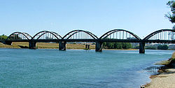
, which joins the Clutha 30 kilometres (18.6 mi) from the coast. The river passes the town of Balclutha
Balclutha, New Zealand
Balclutha is a town in Otago, it lies towards the end of the Clutha River on the east coast of the South Island of New Zealand. It is about halfway between Dunedin and Invercargill on the Main South Line railway, State Highway 1 and the Southern Scenic Route...
before widening into the Clutha delta which contains the large flat island of Inch Clutha
Inch Clutha
Inch Clutha is a large, flat island sitting in the delta between the Matau and Koau branches of the Clutha River, downstream from the town of Balclutha in the South Island of New Zealand...
. Here the river divides into two branches, the Matau (northern), which flows past Kaitangata
Kaitangata, New Zealand
Kaitangata is a town near the coast of South Otago, New Zealand, on the left bank of the Clutha River ten kilometres south east of Balclutha. The town is known to its residents simply as Kai....
, and Koau (southern). Both branches flow into the Pacific Ocean at Molyneux Bay.
The Clutha's average discharge is estimated at 614 m3/s, comparable to many much larger rivers. This heavy flow, combined with the relatively small size of the river in global terms, makes the Clutha notoriously fast-flowing, and it is often listed as one of the world's most swiftly flowing rivers, alongside Australia's Macleay
Macleay River
The Macleay River is a major river on the Mid North Coast , Australia.The headwaters of the Macleay River rise as the Gara River on the eastern side of the Northern Tablelands near Armidale and Walcha, New South Wales. From here the Chandler River, Styx River and Apsley Rivers are important...
and Fitzroy River
Fitzroy River (Western Australia)
The Fitzroy River is located in the West Kimberley region of Western Australia.-Discovery:The Fitzroy River was discovered by the West in 1837 by George Grey in the H.M.S. Beagle. The river was subsequently named by Lt J L Stokes on 26/2/1838 after Captain Robert FitzRoy R.N...
s, the Amazon
Amazon River
The Amazon of South America is the second longest river in the world and by far the largest by waterflow with an average discharge greater than the next seven largest rivers combined...
and Atrato River
Atrato River
The Río Atrato is a river of northwestern Colombia. It rises in the slopes of the Western Cordillera and flows almost due north to the Gulf of Urabá , where it forms a large, swampy delta....
s in South America, and the Teesta River
Teesta River
River Teesta or Tista is said to be the lifeline of the Indian state of Sikkim, flowing for almost the entire length of the state and carving out verdant Himalayan temperate and tropical river valleys. The emerald-coloured river then forms the border between Sikkim and West Bengal before joining...
in the Himalaya.
The waters of the Upper Clutha are clear turquoise, the result of glacial and snow-melt filtering when the water flows through Lake Wanaka. This is a rare characteristic for a high volume river. Below Cromwell, where the silt-laden Kawarau
Kawarau River
Kawarau River drains Lake Wakatipu, in northwestern Otago, New Zealand. The river flows generally eastwards for about 60 km and passes through the steep Kawarau Gorge until it joins Lake Dunstan near Cromwell. The Shotover River enters it from the north; the Nevis River enters it from the south...
enters, the waters are less turquoise.
Beyond the river's mouth
Such is the nature of the geology of the New Zealand region that the true river tells only half the story of the Clutha's course. Beyond its mouth, a submarine canyon system extends for over 100 kilometres into the South Pacific Ocean, eventually becoming the Bounty Trough. The canyon system bears a remarkable resemblance to the pattern of river and tributaries visible on land, so much so that many of the rivers which empty into the sea along the Otago coast can virtually be considered tributaries of the Clutha's submarine system. These rivers include the TokomairiroTokomairiro River
The Tokomairiro River is located in Otago, New Zealand. It flows southeast for some 50 kilometres , reaching the Pacific Ocean at Toko Mouth 50 kilometres south of Dunedin...
, Taieri
Taieri River
The Taieri River is the fourth-longest river in New Zealand and is located in Otago in the South Island. Rising in the Lammerlaw ranges, it initially flows north, then east around the Rock and Pillar range before turning southeast, reaching the sea 30 km south of Dunedin.The upper reaches meander...
, Waikouaiti
Waikouaiti River
240px|thumb|Waikouaiti River estuary at [[Karitane]]; fishing wharf and channel to the [[Pacific Ocean]] at right, [[Matanaka]] headland at left background....
, Shag
Shag River
Shag River is located in Otago in the South Island of New Zealand. It rises in the Kakanui Range, flowing southeast for 50 kilometres before reaching the Pacific Ocean near the town of Palmerston...
, and even the Waitaki
Waitaki River
The Waitaki River is a large river in the South Island of New Zealand, some 110 km long. It is the major river of the Mackenzie Basin.It is a braided river which flows through Lake Benmore, Lake Aviemore and Lake Waitaki. These are ultimately fed by three large glacial lakes, Pukaki, Tekapo,...
.
History
The upper reaches of the river once abounded in flightless MoaMoa
The moa were eleven species of flightless birds endemic to New Zealand. The two largest species, Dinornis robustus and Dinornis novaezelandiae, reached about in height with neck outstretched, and weighed about ....
, predated upon by the Haast's Eagle
Haast's Eagle
Haast's Eagle was a species of massive eagles that once lived on the South Island of New Zealand. The species was the largest eagle known to have existed. Its prey consisted mainly of gigantic flightless birds that were unable to defend themselves from the striking force and speed of these eagles,...
. The river was known by the Māori as Mata-au, meaning current or eddy in an expanse of water. This name, now more frequently rendered as Matau, is still used for one of the two main channels of the Clutha delta. In the early days of European exploration there was at least one settlement of some 250-300 Māori close to the river's banks. The river takes its European name from Cluaidh, the Scots Gaelic name for the River Clyde
River Clyde
The River Clyde is a major river in Scotland. It is the ninth longest river in the United Kingdom, and the third longest in Scotland. Flowing through the major city of Glasgow, it was an important river for shipbuilding and trade in the British Empire....
in Scotland
Scotland
Scotland is a country that is part of the United Kingdom. Occupying the northern third of the island of Great Britain, it shares a border with England to the south and is bounded by the North Sea to the east, the Atlantic Ocean to the north and west, and the North Channel and Irish Sea to the...
which runs through Glasgow
Glasgow
Glasgow is the largest city in Scotland and third most populous in the United Kingdom. The city is situated on the River Clyde in the country's west central lowlands...
. During New Zealand's early colonial history it was known as the Molyneux, that name given to it by Captain Cook
James Cook
Captain James Cook, FRS, RN was a British explorer, navigator and cartographer who ultimately rose to the rank of captain in the Royal Navy...
. During early European settlement, a whaling station was established close to the river's mouth, and during this period the sea was the source of almost all of the area's economy.
Gold rush
The river featured greatly in the Central Otago goldrush. The first major goldGold
Gold is a chemical element with the symbol Au and an atomic number of 79. Gold is a dense, soft, shiny, malleable and ductile metal. Pure gold has a bright yellow color and luster traditionally considered attractive, which it maintains without oxidizing in air or water. Chemically, gold is a...
deposits in Otago were discovered around the Tuapeka River
Tuapeka River
The Tuapeka River is located in Otago in the South Island of New Zealand. It is a tributary of the Clutha River, which it joins at Tuapeka Mouth between Roxburgh and Balclutha....
at Gabriel's Gully
Gabriel's Gully
Gabriel's Gully is a locality in Otago, New Zealand, three kilometres from Lawrence township and close to the Tuapeka River.The discovery of gold at Gabriel's Gully by Gabriel Read in May 1861 led to the Central Otago goldrush...
by Gabriel Read
Gabriel Read
Gabriel Read was an Australian gold prospector who, after working on the goldfields of California and Victoria, Australia travelled to New Zealand, having heard rumours of gold being found in Mataura, Southland. On 20 May 1861, he discovered gold close to the banks of the Tuapeka River in Otago,...
in 1861, and the following year large amounts of the precious metal were discovered close to the site of modern Cromwell
Cromwell, New Zealand
Cromwell is a town in Central Otago in the Otago region of New Zealand.It is situated between State Highway 6 and State Highway 8 leading to the Lindis Pass, 75 km northeast, and Alexandra, 33 km south. The road to Alexandra winds through the Cromwell Gorge...
.
By Christmas
Christmas
Christmas or Christmas Day is an annual holiday generally celebrated on December 25 by billions of people around the world. It is a Christian feast that commemorates the birth of Jesus Christ, liturgically closing the Advent season and initiating the season of Christmastide, which lasts twelve days...
1861, 14,000 prospectors were on the Tuapeka and Waipori fields. The gold rush was short-lived, with most of the alluvial gold played out by 1863, but prospectors continued to arrive, swelling to a maximum of 18,000 miners in February 1864.
Floods
Flood
A flood is an overflow of an expanse of water that submerges land. The EU Floods directive defines a flood as a temporary covering by water of land not normally covered by water...
s have occurred on the Clutha, most notably the “Hundred year floods” of 14–16 October 1878 and 13–15 October 1978. The 1878 flood is regarded as New Zealand's greatest known flood. During this, a bridge at Clydevale was washed downstream, where it collided with the Balclutha Road Bridge, destroying the latter.
The 1978 flood, in which rivers from the Oreti
Oreti River
The Oreti River is one of the main rivers of Southland, New Zealand, and is 170 kilometres in length.The Oreti has its headwaters close to the Mavora Lakes between Lake Te Anau and Lake Wakatipu, and flows south across the Southland Plains to its outflow into Foveaux Strait at the southeastern end...
in the south to the Tokomairiro
Tokomairiro River
The Tokomairiro River is located in Otago, New Zealand. It flows southeast for some 50 kilometres , reaching the Pacific Ocean at Toko Mouth 50 kilometres south of Dunedin...
in the north breached their banks, led to the inundation of over 12000 hectares (29,652.6 acre) of land and the loss of over 21,000 livestock. Towns and areas affected stretched from Makarora
Makarora
Makarora is a small community within the Queenstown-Lakes District of the Otago region of the South Island of New Zealand.It is situated on State Highway 6 on the eastern side of the Haast Pass and adjacent to the Makarora River....
in the north to Invercargill
Invercargill
Invercargill is the southernmost and westernmost city in New Zealand, and one of the southernmost cities in the world. It is the commercial centre of the Southland region. It lies in the heart of the wide expanse of the Southland Plains on the Oreti or New River some 18 km north of Bluff,...
in the south. The town of Wyndham
Wyndham, New Zealand
Wyndham is a rural town of 550 people in the South Island of New Zealand in the Southland region, 45 km east of Invercargill and 25 km south of Gore. The original Māori name of the locality was Mokoreta .Wyndham was named for General Sir Charles Ashe Windham who fought in the Crimean War...
was completely evacuated, and the towns of Balclutha
Balclutha, New Zealand
Balclutha is a town in Otago, it lies towards the end of the Clutha River on the east coast of the South Island of New Zealand. It is about halfway between Dunedin and Invercargill on the Main South Line railway, State Highway 1 and the Southern Scenic Route...
, Milton
Milton, New Zealand
Milton is a town of 2,000 people, located on State Highway 1, 50 kilometres to the south of Dunedin in Otago, New Zealand. It lies on the floodplain of the Tokomairiro River, one branch of which loops past the north and south ends of the town...
and Mataura
Mataura
Mataura is a town in the Southland region of the South Island of New Zealand. Mataura has a meat processing plant, and until 2000 it was the site of a large pulp and paper mill....
were seriously affected with many residents moved. The small settlement of Kelso
Kelso, New Zealand
Kelso was a small settlement in Otago, New Zealand, located ten kilometres north of Tapanui on the Kelso River, close to its junction with the larger Pomahaka River...
on the banks of the Pomahaka River
Pomahaka River
The Pomahaka River is located in South Otago in New Zealand's South Island. It is a tributary of the Clutha River, flowing south for 80 kilometres from the Old Man Range of mountains to join the Clutha just north of Balclutha...
was completely abandoned and was not rebuilt once the waters subsided. At its peak, at 6.00 a.m. on the 15th, the Clutha's flow was measured at just over 4500 m3/s.
A major flood in 1999 caused serious damage to river communities, especially Alexandra
Alexandra, New Zealand
Alexandra is a town in the Central Otago district of the Otago region of New Zealand. It is located on the banks of the Clutha River , on State Highway 8, 188 km by road from Dunedin and 33 km south of Cromwell.At the time of the 2006 census, the permanent population was 4,827, an...
. The flooding in Alexandra was attributed to a rise in the riverbed, resulting from silt loading in the Roxburgh reservoir behind the Roxburgh Dam
Roxburgh Dam
The Roxburgh Dam is the earliest of the large hydroelectric projects in the southern South Island of New Zealand. It lies across the Clutha River / Mata-Au, some from Dunedin, some to the north of the town of Roxburgh...
downriver from the town. The 1878 flood had not flooded the town, but the 1999 did, despite being only 80% of the volume of the 1878 flood. http://www.alexfloods.org.nz.
Water usage
There are two hydroelectric power stations, the Clyde DamClyde Dam
The Clyde Dam, New Zealand's third largest hydroelectric dam, is built on the Clutha River near the town of Clyde. It is owned and operated by Contact Energy.-History:...
and the Roxburgh Dam
Roxburgh Dam
The Roxburgh Dam is the earliest of the large hydroelectric projects in the southern South Island of New Zealand. It lies across the Clutha River / Mata-Au, some from Dunedin, some to the north of the town of Roxburgh...
, located on the river providing electricity to the New Zealand power grid.
Apple
The apple is the pomaceous fruit of the apple tree, species Malus domestica in the rose family . It is one of the most widely cultivated tree fruits, and the most widely known of the many members of genus Malus that are used by humans. Apple grow on small, deciduous trees that blossom in the spring...
s, apricot
Apricot
The apricot, Prunus armeniaca, is a species of Prunus, classified with the plum in the subgenus Prunus. The native range is somewhat uncertain due to its extensive prehistoric cultivation.- Description :...
s, nectarines, cherries
Cherry
The cherry is the fruit of many plants of the genus Prunus, and is a fleshy stone fruit. The cherry fruits of commerce are usually obtained from a limited number of species, including especially cultivars of the wild cherry, Prunus avium....
, and peach
Peach
The peach tree is a deciduous tree growing to tall and 6 in. in diameter, belonging to the subfamily Prunoideae of the family Rosaceae. It bears an edible juicy fruit called a peach...
es. Several small vineyards
Viticulture
Viticulture is the science, production and study of grapes which deals with the series of events that occur in the vineyard. When the grapes are used for winemaking, it is also known as viniculture...
are also found in the upper reaches of the river.
The spectacular scenery of Central Otago makes the upper Clutha a popular holiday destination, especially for adventure tourism. Jetboat
Jetboat
A jetboat is a boat propelled by a jet of water ejected from the back of the craft. Unlike a powerboat or motorboat that uses a propeller in the water below or behind the boat, a jetboat draws the water from under the boat into a pump inside the boat, then expels it through a nozzle at the...
ing, kayaking
Kayaking
Kayaking is the use of a kayak for moving across water. Kayaking and canoeing are also known as paddling. Kayaking is distinguished from canoeing by the sitting position of the paddler and the number of blades on the paddle...
, rafting
Rafting
Rafting or white water rafting is a challenging recreational outdoor activity using an inflatable raft to navigate a river or other bodies of water. This is usually done on white water or different degrees of rough water, in order to thrill and excite the raft passengers. The development of this...
, riverboarding
Riverboarding
Riverboarding is a boardsport in which the participant lies prone on their board with fins on their feet for propulsion and steering. This sport is also known as hydrospeed in Europe and as riverboarding or white-water sledging in New Zealand, depending on the type of board used...
, and guided fishing
Fishing
Fishing is the activity of trying to catch wild fish. Fish are normally caught in the wild. Techniques for catching fish include hand gathering, spearing, netting, angling and trapping....
occurs on the river, and waterskiing, tandem parachuting
Parachuting
Parachuting, also known as skydiving, is the action of exiting an aircraft and returning to earth with the aid of a parachute. It may or may not involve a certain amount of free-fall, a time during which the parachute has not been deployed and the body gradually accelerates to terminal...
and parapenting operators are all to be found in the area. The upper Clutha is also used for multi-sports events, and Lake Dunstan is an important rowing
Watercraft rowing
Watercraft rowing is the act of propelling a boat using the motion of oars in the water. The difference between paddling and rowing is that with rowing the oars have a mechanical connection with the boat whereas with paddling the paddles are hand-held with no mechanical connection.This article...
venue. Several major ski courses
Skiing
Skiing is a recreational activity using skis as equipment for traveling over snow. Skis are used in conjunction with boots that connect to the ski with use of a binding....
are found close to the river. Curling
Curling
Curling is a sport in which players slide stones across a sheet of ice towards a target area. It is related to bowls, boule and shuffleboard. Two teams, each of four players, take turns sliding heavy, polished granite stones, also called "rocks", across the ice curling sheet towards the house, a...
is also played close to the Clutha in the harsh Central Otago winters.