
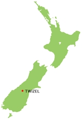
Twizel
Encyclopedia
| Twizel | |
| Urban Area | |
|---|---|
| Population: | 1,000 |
| Extent: | |
| Territorial Authority | |
| Name: | Mackenzie District Council |
| Population: | |
| Mayor: | |
| Website: | Mackenzie District Council |
| Extent: | |
| Regional council | |
| Name: | Environment Canterbury |
- There is also a TwizellTwizell CastleTwizell Castle is a Grade II* listed building and a Scheduled Ancient Monument which stands on a bend of the River Till at Tillmouth Park, Northumberland, northern England. Below it, the medieval Twizell bridge spans the river. It is located south-west of Berwick Upon Tweed. The site is visible...
in NorthumberlandNorthumberlandNorthumberland is the northernmost ceremonial county and a unitary district in North East England. For Eurostat purposes Northumberland is a NUTS 3 region and is one of three boroughs or unitary districts that comprise the "Northumberland and Tyne and Wear" NUTS 2 region...
, EnglandEnglandEngland is a country that is part of the United Kingdom. It shares land borders with Scotland to the north and Wales to the west; the Irish Sea is to the north west, the Celtic Sea to the south west, with the North Sea to the east and the English Channel to the south separating it from continental...
Twizel is a town
Town
A town is a human settlement larger than a village but smaller than a city. The size a settlement must be in order to be called a "town" varies considerably in different parts of the world, so that, for example, many American "small towns" seem to British people to be no more than villages, while...
in the Mackenzie Basin
Mackenzie Basin
The Mackenzie Basin , is an elliptical intermontane basin, located in the Mackenzie and Waitaki Districts, near the centre of the South Island of New Zealand. It is the largest such basin in New Zealand...
, part of the Mackenzie District
Mackenzie District
Mackenzie District is a political district in New Zealand's South Island. It is part of the larger Canterbury Region.-Principal settlements:*Fairlie*Twizel*Cave*Mount Cook Village*Albury*TekapoAlso*Burkes Pass-Geography:See Mackenzie Basin,...
of the Canterbury
Canterbury, New Zealand
The New Zealand region of Canterbury is mainly composed of the Canterbury Plains and the surrounding mountains. Its main city, Christchurch, hosts the main office of the Christchurch City Council, the Canterbury Regional Council - called Environment Canterbury - and the University of Canterbury.-...
region of New Zealand
New Zealand
New Zealand is an island country in the south-western Pacific Ocean comprising two main landmasses and numerous smaller islands. The country is situated some east of Australia across the Tasman Sea, and roughly south of the Pacific island nations of New Caledonia, Fiji, and Tonga...
's South Island
South Island
The South Island is the larger of the two major islands of New Zealand, the other being the more populous North Island. It is bordered to the north by Cook Strait, to the west by the Tasman Sea, to the south and east by the Pacific Ocean...
. Its residential population is 1,017, but in summer the population more than triples. It also is the venue for the maadi rowing cup.
History
Twizel was built in 1968 as a greenfields project to service the Upper Waitaki HydroelectricityHydroelectricity
Hydroelectricity is the term referring to electricity generated by hydropower; the production of electrical power through the use of the gravitational force of falling or flowing water. It is the most widely used form of renewable energy...
Scheme and was intended to be removed once the project had been completed. However, in 1983 its residents successfully fought to save the town. At the height of the project in the 1970s, the population peaked at around 6,000.
Prior to 1968, where Twizel now stands was farmland. The town was laid out in a 'Scandinavian' fashion, where the shops, school, and recreational parkland formed a hub in the centre of the town, around which the residential area lay. This design style features looping roads and pedestrian ways, making it usually far more direct to walk than use a car. A previous version of this layout had been tried at Otematata. It was intended that the houses for the engineers would be built near Lake Pukaki
Lake Pukaki
Lake Pukaki is the largest of three roughly parallel alpine lakes running north-south along the northern edge of the Mackenzie Basin on New Zealand's South Island. The others are Lakes Tekapo and Ohau...
but they were built in Twizel. Accommodation was highly segregated: in addition to singlemen's quarters in the middle of town, there was a series of different houses available, with the smallest for workers, staff houses for teachers and professionals, and the largest for engineers and other high-status residents. Most houses were prefabricated, and intended to be portable. Some were brought from Otematata, and some were moved to Clyde
Clyde, New Zealand
Clyde is a small town in Central Otago, New Zealand with a population of 918 in 2006. It is located on the Clutha River, between Cromwell and Alexandra....
for the next hydroelectricity project.
Because the intention was for the town to be reverted to farmland, there were many 'temporary' features. For example, instead of putting in kerbing, channels, and footpaths at the edge of the road, a single expanse of seal was contoured in a very flat 'W' shape: the seal was highest at the outer edge (footpath) and in the middle (centreline), with a lower area serving as a channel and delineation between the roadway and footpath.
Industries
Twizel is a now a service and tourist town for visitors. Nearby Lake RuataniwhaLake Ruataniwha
Lake Ruataniwha is located in the Mackenzie Basin in New Zealand's South Island. An artificial lake, it was formed as part of the Waitaki hydroelectric project....
supports sailing
Sailing
Sailing is the propulsion of a vehicle and the control of its movement with large foils called sails. By changing the rigging, rudder, and sometimes the keel or centre board, a sailor manages the force of the wind on the sails in order to move the boat relative to its surrounding medium and...
, water skiing
Water skiing
thumb|right|A slalom skier making a turn on a slalom waterski.Waterskiing is a sport where an individual is pulled behind a boat or a cable ski installation on a body of water, skimming the surface.-History:...
and prominent rowing
Sport rowing
Rowing is a sport in which athletes race against each other on rivers, on lakes or on the ocean, depending upon the type of race and the discipline. The boats are propelled by the reaction forces on the oar blades as they are pushed against the water...
events, such as the Maadi Cup
Maadi Cup
The Maadi Cup is the prize for the New Zealand Secondary Schools Boys' Under 18 Rowing Eights. More colloquially, it is the name given to the New Zealand Secondary Schools Rowing Regatta, at which the Maadi Cup is raced...
, while the Ohau Skifield
Ohau (skifield)
Ohau is a small commercial skifield in the foothills of New Zealand's Southern Alps, near the boundary between the Otago and Canterbury regions, and close to the southwestern shore of the lake of the same name.- Details :...
and the Round Hill Ski Area
Roundhill Ski Area
Roundhill Ski Area is a family run skifield in Canterbury, New Zealand, near the town of Tekapo, 3 hours from both Christchurch and Queenstown....
attract winter tourists.
The area boasts one of the world's cleanest, driest and darkest skies, and has long drawn astronomer
Astronomer
An astronomer is a scientist who studies celestial bodies such as planets, stars and galaxies.Historically, astronomy was more concerned with the classification and description of phenomena in the sky, while astrophysics attempted to explain these phenomena and the differences between them using...
s to Twizel and the surrounding area
Mackenzie Basin
The Mackenzie Basin , is an elliptical intermontane basin, located in the Mackenzie and Waitaki Districts, near the centre of the South Island of New Zealand. It is the largest such basin in New Zealand...
, with several existing astro-tourism ventures, such as at Lake Tekapo
Lake Tekapo
Lake Tekapo is the second-largest of three roughly parallel lakes running north–south along the northern edge of the Mackenzie Basin in the South Island of New Zealand...
and Omarama
Omarama
Omarama is a small township at the junction of State Highways 8 and 83, near the southern end of the Mackenzie Basin, in the South Island of New Zealand. Omarama is in the Waitaki District, in the historic Province of Otago...
catering to their needs, while two additional observatories are under development, in Twizel and at Mount Cook Village
Mount Cook Village
Mount Cook VillageUrban AreaPopulation:Extent:Territorial AuthorityName:Mackenzie District CouncilPopulation:Mayor:Website:Extent:Regional councilName:Environment Canterbury...
.
Transport
Twizel will be on the route of the Alps to Ocean Cycle TrailAlps to Ocean Cycle Trail
The Alps to Ocean Cycle Trail is a cycle trail funded as one of the projects of the New Zealand Cycle Trail system in Otago and Canterbury, New Zealand...
, to be constructed in the following years after approval in 2010.