

Historic tsunamis
Encyclopedia
Tsunami
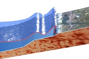
A tsunami is a series of water waves caused by the displacement of a large volume of a body of water, typically an ocean or a large lake...
occurred, the earthquake
Earthquake
An earthquake is the result of a sudden release of energy in the Earth's crust that creates seismic waves. The seismicity, seismism or seismic activity of an area refers to the frequency, type and size of earthquakes experienced over a period of time...
that generated it, or both.
Because of seismic and volcanic activity at tectonic plate boundaries along the Pacific Ring of Fire
Pacific Ring of Fire
The Pacific Ring of Fire is an area where large numbers of earthquakes and volcanic eruptions occur in the basin of the Pacific Ocean. In a horseshoe shape, it is associated with a nearly continuous series of oceanic trenches, volcanic arcs, and volcanic belts and/or plate movements...
, tsunamis occur most frequently in the Pacific Ocean
Pacific Ocean
The Pacific Ocean is the largest of the Earth's oceanic divisions. It extends from the Arctic in the north to the Southern Ocean in the south, bounded by Asia and Australia in the west, and the Americas in the east.At 165.2 million square kilometres in area, this largest division of the World...
, but are worldwide natural phenomena. They are possible wherever large bodies of water are found, including inland lakes, where they can be caused by landslides and glacier calving. Very small tsunamis, non-destructive and undetectable without specialized equipment, occur frequently as a result of minor earthquakes and other events.
As early as 426 BC, the Greek
Ancient Greece
Ancient Greece is a civilization belonging to a period of Greek history that lasted from the Archaic period of the 8th to 6th centuries BC to the end of antiquity. Immediately following this period was the beginning of the Early Middle Ages and the Byzantine era. Included in Ancient Greece is the...
historian Thucydides
Thucydides
Thucydides was a Greek historian and author from Alimos. His History of the Peloponnesian War recounts the 5th century BC war between Sparta and Athens to the year 411 BC...
inquired in his book History of the Peloponnesian War
History of the Peloponnesian War
The History of the Peloponnesian War is an account of the Peloponnesian War in Ancient Greece, fought between the Peloponnesian League and the Delian League . It was written by Thucydides, an Athenian general who served in the war. It is widely considered a classic and regarded as one of the...
(3.89.1-6) about the causes of tsunamis. He argued rightly that it could only be explained as a consequence of ocean earthquakes, and could see no other possible causes for the phenomenon.
Crete
Crete
Crete is the largest and most populous of the Greek islands, the fifth largest island in the Mediterranean Sea, and one of the thirteen administrative regions of Greece. It forms a significant part of the economy and cultural heritage of Greece while retaining its own local cultural traits...
and the Argolid and other locations were destroyed by a tsunami caused by the eruption of Thira, which destroyed Minoan civilization
Minoan civilization
The Minoan civilization was a Bronze Age civilization that arose on the island of Crete and flourished from approximately the 27th century BC to the 15th century BC. It was rediscovered at the beginning of the 20th century through the work of the British archaeologist Arthur Evans...
on Crete
Crete
Crete is the largest and most populous of the Greek islands, the fifth largest island in the Mediterranean Sea, and one of the thirteen administrative regions of Greece. It forms a significant part of the economy and cultural heritage of Greece while retaining its own local cultural traits...
and related cultures in the Cyclades
Cyclades
The Cyclades is a Greek island group in the Aegean Sea, south-east of the mainland of Greece; and a former administrative prefecture of Greece. They are one of the island groups which constitute the Aegean archipelago. The name refers to the islands around the sacred island of Delos...
and in areas facing the eruption on the Greek mainland such as the Argolid.
During the Persian siege of the sea town Potidaea
Potidaea
Potidaea was a colony founded by the Corinthians around 600 BC in the narrowest point of the peninsula of Pallene, the westernmost of three peninsulas at the southern end of Chalcidice in northern Greece....
, Greece
Greece
Greece , officially the Hellenic Republic , and historically Hellas or the Republic of Greece in English, is a country in southeastern Europe....
, in 479 BC, the Greek
Ancient Greece
Ancient Greece is a civilization belonging to a period of Greek history that lasted from the Archaic period of the 8th to 6th centuries BC to the end of antiquity. Immediately following this period was the beginning of the Early Middle Ages and the Byzantine era. Included in Ancient Greece is the...
historian Herodotus
Herodotus
Herodotus was an ancient Greek historian who was born in Halicarnassus, Caria and lived in the 5th century BC . He has been called the "Father of History", and was the first historian known to collect his materials systematically, test their accuracy to a certain extent and arrange them in a...
reports how the Persian attackers who tried to exploit an unusual retreat of the water were suddenly surprised by "a great flood-tide, higher, as the people of the place say, than any one of the many that had been before". Herodotus attributes the cause of the sudden flood to the wrath of Poseidon
Poseidon
Poseidon was the god of the sea, and, as "Earth-Shaker," of the earthquakes in Greek mythology. The name of the sea-god Nethuns in Etruscan was adopted in Latin for Neptune in Roman mythology: both were sea gods analogous to Poseidon...
.
≈6100 BC: Norwegian Sea
The Storegga Slides occurred 100 km north-west of the MøreMøre og Romsdal
is a county in the northernmost part of Western Norway. It borders the counties of Sør-Trøndelag, Oppland and Sogn og Fjordane. The county administration is located in Molde, while Ålesund is the largest city.-The name:...
coast in the Norwegian Sea
Norwegian Sea
The Norwegian Sea is a marginal sea in the North Atlantic Ocean, northwest of Norway. It is located between the North Sea and the Greenland Sea and adjoins the North Atlantic Ocean to the west and the Barents Sea to the northeast. In the southwest, it is separated from the Atlantic Ocean by a...
, causing a very large tsunami
Tsunami
A tsunami is a series of water waves caused by the displacement of a large volume of a body of water, typically an ocean or a large lake...
in the North Atlantic Ocean. This collapse involved an estimated 290 km length of coastal shelf, with a total volume of 3,500 km3 of debris. Based on carbon dating of plant material recovered from sediment deposited by the tsunami, the latest incident occurred around 6100 BC. In Scotland
Scotland
Scotland is a country that is part of the United Kingdom. Occupying the northern third of the island of Great Britain, it shares a border with England to the south and is bounded by the North Sea to the east, the Atlantic Ocean to the north and west, and the North Channel and Irish Sea to the...
, traces of the subsequent tsunami have been recorded, with deposited sediment being discovered in Montrose Basin
Montrose Basin
The Montrose Basin is part of the estuary of the South Esk forming a tidal basin near to the town of Montrose, Angus, on the north-east coast of Scotland....
, the Firth of Forth
Firth of Forth
The Firth of Forth is the estuary or firth of Scotland's River Forth, where it flows into the North Sea, between Fife to the north, and West Lothian, the City of Edinburgh and East Lothian to the south...
, up to 80 km inland and 4 metres above current normal tide levels.
≈1600 BC: Santorini, Greece
The volcanic eruption on Santorini, Greece is assumed to have caused severe damage to cities around it, most notably the Minoan civilizationMinoan civilization
The Minoan civilization was a Bronze Age civilization that arose on the island of Crete and flourished from approximately the 27th century BC to the 15th century BC. It was rediscovered at the beginning of the 20th century through the work of the British archaeologist Arthur Evans...
on Crete
Crete
Crete is the largest and most populous of the Greek islands, the fifth largest island in the Mediterranean Sea, and one of the thirteen administrative regions of Greece. It forms a significant part of the economy and cultural heritage of Greece while retaining its own local cultural traits...
. A tsunami is assumed to be the factor that caused the most damage.
426 BC: Malian Gulf, Greece
In the summer of 426 BC, a tsunami hit the Malian GulfMalian Gulf
The Malian or Maliac Gulf is a gulf of the Aegean Sea in the region of Phthiotis in eastern Central Greece. The gulf is named after the ancient Malians who lived on its shores....
between the northwest tip of Euboea
Euboea
Euboea is the second largest Greek island in area and population, after Crete. The narrow Euripus Strait separates it from Boeotia in mainland Greece. In general outline it is a long and narrow, seahorse-shaped island; it is about long, and varies in breadth from to...
and Lamia
Lamia
Lamia may refer to:* Lamia , a Greek mythological female creature* Lamia of Athens courtesan* Lamia , a magical beast in Dungeons & Dragons* Lamia , a city in Greece* Lamia , a genus of longhorn beetles...
. The Greek historian Thucydides
Thucydides
Thucydides was a Greek historian and author from Alimos. His History of the Peloponnesian War recounts the 5th century BC war between Sparta and Athens to the year 411 BC...
(3.89.1-6) described how the tsunami and a series of earthquakes intervened with the events of the raging Peloponnesian War
Peloponnesian War
The Peloponnesian War, 431 to 404 BC, was an ancient Greek war fought by Athens and its empire against the Peloponnesian League led by Sparta. Historians have traditionally divided the war into three phases...
(431-404 BC) and correlated for the first time in the history of natural science
Natural science
The natural sciences are branches of science that seek to elucidate the rules that govern the natural world by using empirical and scientific methods...
quakes and waves in terms of cause and effect.
373 BC: Helike, Greece
An earthquake and a tsunami destroyed the prosperous Greek city HelikeHelike
Helike was an ancient Greek city that sank at night in the winter of 373 BC. The city was located in Achaea, Northern Peloponnesos, two kilometres from the Corinthian Gulf...
, lying 2 km away from the sea. The fate of the city, which remained permanently submerged, was often commented upon by ancient writers and may have inspired the contemporary Plato
Plato
Plato , was a Classical Greek philosopher, mathematician, student of Socrates, writer of philosophical dialogues, and founder of the Academy in Athens, the first institution of higher learning in the Western world. Along with his mentor, Socrates, and his student, Aristotle, Plato helped to lay the...
to the myth of Atlantis
Atlantis
Atlantis is a legendary island first mentioned in Plato's dialogues Timaeus and Critias, written about 360 BC....
.
79 AD: Gulf of Naples, Italy
A smaller tsunami was witnessed in the Bay of NaplesGulf of Naples
The Gulf of Naples is a c. 15 km wide gulf located in the south western coast of Italy, . It opens to the west into the Mediterranean Sea. It is bordered on the north by the cities of Naples and Pozzuoli, on the east by Mount Vesuvius, and on the south by the Sorrentine Peninsula and the main...
by Pliny the Younger
Pliny the Younger
Gaius Plinius Caecilius Secundus, born Gaius Caecilius or Gaius Caecilius Cilo , better known as Pliny the Younger, was a lawyer, author, and magistrate of Ancient Rome. Pliny's uncle, Pliny the Elder, helped raise and educate him...
during the eruption
Eruption of Mount Vesuvius in AD 79
In the year of AD 79, Mount Vesuvius erupted in one of the most catastrophic and famous eruptions of all time. The Roman vicinities of Pompeii, Herculaneum and Stabiae were affected, and Pompeii and Herculaneum were obliterated...
of Mount Vesuvius.
365 AD: Alexandria, Eastern Mediterranean
In the morning of July 21, 365 AD, an earthquake of great magnitude caused a huge tsunami more than 100 feet (30.5 m) high. It devastated AlexandriaAlexandria
Alexandria is the second-largest city of Egypt, with a population of 4.1 million, extending about along the coast of the Mediterranean Sea in the north central part of the country; it is also the largest city lying directly on the Mediterranean coast. It is Egypt's largest seaport, serving...
and the eastern shores of the Mediterranean, killing thousands and hurling ships nearly two miles inland. The Roman
Ancient Rome
Ancient Rome was a thriving civilization that grew on the Italian Peninsula as early as the 8th century BC. Located along the Mediterranean Sea and centered on the city of Rome, it expanded to one of the largest empires in the ancient world....
historian Ammianus Marcellinus
Ammianus Marcellinus
Ammianus Marcellinus was a fourth-century Roman historian. He wrote the penultimate major historical account surviving from Antiquity...
(Res Gestae 26.10.15-19) describes in his vivid account the typical sequence of the tsunami including an incipient earthquake, the sudden retreat of the sea and a following gigantic wave:
The tsunami in 365 AD was so devastating that the anniversary of the disaster was still commemorated annually at the end of the 6th century in Alexandria as a "day of horror."
Researchers at the University of Cambridge
University of Cambridge
The University of Cambridge is a public research university located in Cambridge, United Kingdom. It is the second-oldest university in both the United Kingdom and the English-speaking world , and the seventh-oldest globally...
recently carbon dated corals on the coast of Crete
Crete
Crete is the largest and most populous of the Greek islands, the fifth largest island in the Mediterranean Sea, and one of the thirteen administrative regions of Greece. It forms a significant part of the economy and cultural heritage of Greece while retaining its own local cultural traits...
which were lifted 10 metres and clear of the water in one massive push. This indicates that the tsunami of 365 AD was generated by an earthquake in a steep fault in the Hellenic trench near Crete. The scientists estimate that such a large uplift is only likely to occur once in 5,000 years, however the other segments of the fault could slip on a similar scale - and could happen every 800 years or so. It is unsure whether "one of the contiguous patches might slip in the future."
684 AD: Hakuho, Japan (白鳳大地震)
JapanJapan
Japan is an island nation in East Asia. Located in the Pacific Ocean, it lies to the east of the Sea of Japan, China, North Korea, South Korea and Russia, stretching from the Sea of Okhotsk in the north to the East China Sea and Taiwan in the south...
is the nation with the most recorded tsunamis in the world. The number of tsunamis in Japan totals 195 over a 1,313 year period (thru 1997), averaging one event every 6.73 years, the highest rate of occurrence in the world.
The Great Hakuho Earthquake was the first recorded tsunami in Japan. It hit in Japan on November 29, 684. It occurred off the shore of the Kii Peninsula
Kii Peninsula
The is the largest peninsula on the island of Honshū in Japan. The area south of the “Central Tectonic Line” is called Nankii , and includes the most poleward living coral reefs in the world due to the presence of the warm Kuroshio Current, though these are threatened by global warming and human...
, Nankaido
Nankaido
The , literally meaning "southern sea road," is a Japanese term denoting both an ancient division of the country and the main road running through it. The road connected provincial capitals in this region...
, Shikoku
Shikoku
is the smallest and least populous of the four main islands of Japan, located south of Honshū and east of the island of Kyūshū. Its ancient names include Iyo-no-futana-shima , Iyo-shima , and Futana-shima...
, Kii
Kii Province
, or , was a province of Japan in the part of Honshū that is today Wakayama Prefecture, as well as the southern part of Mie Prefecture. Kii bordered Ise, Izumi, Kawachi, Shima, and Yamato Provinces. The Kii Peninsula takes its name from this province....
, and Awaji
Awaji Province
was an old province of Japan covering Awaji Island, between Honshū and Shikoku. Today it is part of Hyōgo Prefecture. It is sometimes called . Awaji is divided into three municipal sections: Awaji is the northernmost section, Sumoto is the most urban and central section, and four southern towns...
region. It has been estimated to be a magnitude 8.4 It was followed by a huge tsunami, but no estimates on how many deaths.
869 AD: Sendai, Japan
The Sendai region was struck by a major tsunami that caused flooding extending 4 km inland from the coast. The town of TagajōTagajo, Miyagi
is a city located in Miyagi Prefecture, Japan.The city was named after Taga Castle, the capital of Mutsu Province.As of 2010, the city has an estimated population of 63,256 and the population density of 3,220 persons per km². The total area is 19.64 km²....
was destroyed, with an estimated 1,000 casualties.
887 AD: Ninna Nankai, Japan (仁和南海地震)
On August 26 of the NinnaNinna
was a after Gangyō and before Kanpyō. This period spanned the years from February 885 through April 889. The reigning emperors were and .-Change of era:* January 20, 885 : The new era name was created to mark an event or series of events...
era, there was a strong shock in the Kyoto
Kyoto
is a city in the central part of the island of Honshū, Japan. It has a population close to 1.5 million. Formerly the imperial capital of Japan, it is now the capital of Kyoto Prefecture, as well as a major part of the Osaka-Kobe-Kyoto metropolitan area.-History:...
region, causing great destruction and some victims. At the same time, there was a strong earthquake in Osaka
Osaka Prefecture
is a prefecture located in the Kansai region on Honshū, the main island of Japan. The capital is the city of Osaka. It is the center of Osaka-Kobe-Kyoto area.- History :...
, Shiga
Shiga Prefecture
is a prefecture of Japan, which forms part of the Kansai region on Honshu Island. The capital is the city of Ōtsu.- History :Shiga was known as Ōmi Province or Gōshū before the prefectural system was established...
, Gifu
Gifu Prefecture
is a prefecture located in the Chūbu region of central Japan. Its capital is the city of Gifu.Located in the center of Japan, it has long played an important part as the crossroads of Japan, connecting the east to the west through such routes as the Nakasendō...
, and Nagano
Nagano Prefecture
is a prefecture of Japan located in the Chūbu region of the island of Honshū. The capital is the city of Nagano.- History :Nagano was formerly known as the province of Shinano...
prefectures. A tsunami flooded the coastal locality, and some people died. The coast of Osaka and primarily Osaka Bay
Osaka Bay
Osaka Bay is a bay in western Japan. As an eastern part of the Inland Sea, it is separated from the Pacific Ocean by the Kii Channel and from the neighbor western part of the Inland Sea by the Akashi Strait...
suffered especially heavily from the tsunami. The tsunami was also observed on the coast of Hyuga
Hyuga
Hyūga can refer to:* Hyūga, Miyazaki, a city in Japan* Hyūga Province, an old province of Japan* Japanese battleship Hyūga, a battleship of the Imperial Japanese Navy...
-Nada.
1293: Kamakura, Japan (鎌倉大地震)
Magnitude 7.1 Quake and tsunami hit KamakuraKamakura, Kanagawa
is a city located in Kanagawa Prefecture, Japan, about south-south-west of Tokyo. It used to be also called .Although Kamakura proper is today rather small, it is often described in history books as a former de facto capital of Japan as the seat of the Shogunate and of the Regency during the...
, Japan's de facto capital, killing 23,000 after resulting fires.
1303: Eastern Mediterranean
A team from Southern Cross UniversitySouthern Cross University
Southern Cross University is a university based on the North and Mid North Coast of New South Wales, Australia. It is a regional University with more than 14,000 students. The University's primary campus is in Lismore, with other campuses located at Coffs Harbour and Tweed Heads.The University is...
in Lismore, New South Wales
Lismore, New South Wales
Lismore is a subtropical town in northeastern New South Wales, Australia. Lismore is the main population centre in the City of Lismore local government area. Lismore is a regional centre in the Northern Rivers region of the State.-History:...
, Australia, has found geological evidence of five tsunamis that have hit Greece over the past 2000 years. "Most were small and local, but in 1303 a larger one hit Crete, Rhodes, Alexandria and Acre in Israel."
1361: Shōhei Nankai, Japan (正平 & 康安)南海地震)
On Aug 3 of the ShōheiShohei
was a Japanese era name of the Southern Court during the Era of Northern and Southern Courts after Kōkoku and before Kentoku. This period spanned the years from December 1346 to July 1370. The Southern Court emperors in Yoshino were and...
era, a 8.4 Nankaido
Nankaido
The , literally meaning "southern sea road," is a Japanese term denoting both an ancient division of the country and the main road running through it. The road connected provincial capitals in this region...
quake and tsunami hit, with 660 deaths, 1700 houses destroyed. There was a strong earthquake in Tokushima
Tokushima Prefecture
is a prefecture of Japan located on Shikoku island. The capital is the city of Tokushima.- Tokushima Prefecture and Myodo Prefecture :Long ago, Tokushima City belonged to a region known as Myōdō-gun...
, Osaka, Wakayama
Wakayama Prefecture
is a prefecture of Japan located on the Kii Peninsula in the Kansai region on Honshū island. The capital is the city of Wakayama.- History :Present-day Wakayama is mostly the western part of the province of Kii.- 1953 Wakayama Prefecture flood disaster :...
, and Nara
Nara Prefecture
is a prefecture in the Kansai region on Honshū Island, Japan. The capital is the city of Nara.-History:The present-day Nara Prefecture was created in 1887, making it independent of Osaka Prefecture....
Prefectures and on Awaji Island
Awaji Island
is an island in Hyōgo Prefecture, Japan, in the eastern part of the Seto Inland Sea between the islands of Honshū and Shikoku. The island has an area of 592.17 km²...
. A tsunami was observed on the coast of Tokushima and Kochi
Kochi Prefecture
is a prefecture of Japan located on the south coast of Shikoku. The capital is the city of Kōchi.- History :Prior to the Meiji Restoration, Kōchi was known as Tosa Province and was controlled by the Chosokabe clan in the Sengoku period and the Yamauchi family during the Edo period.- Geography...
Prefectures, in Kii Strait and in Osaka Bay.Yunomine Hot Spring (Wakayama Prefecture) stopped. Yukiminato, Awa
Awá
The Awá or Guajá are an endangered indigenous group of people living in the eastern Amazon forests of Brazil. Their language is in the Tupi–Guarani family. Originally living in settlements, they adopted a nomadic lifestyle about 1800 to escape incursions by Europeans...
completely destroyed by tsunami and more than 1,700 houses washed away. 60 persons drowned at Awa.
1498: Meiō Nankai, Japan (明応地震)
Sep 20 7.5 Quake and tsunami hit in the MeiōMeio
, also known as Mei-ō, was a after Entoku and before Bunki. This period spanned the years from July 1492 through February 1501. Reigning emperors were and .-Change of era:...
era. Port in Wakayama damaged by tsunami of several meters in height. 30-40 thousand deaths estimated. The building around great Buddha of Kamakura
Kotoku-in
is a Buddhist temple of the Jōdo-shū sect in the city of Kamakura in Kanagawa Prefecture, Japan.The temple is renowned for its , a monumental outdoor bronze statue of Amida Buddha which is one of the most famous icons of Japan.- The Great Buddha :...
(altitude 7m) was swept away by the tsunami.
1541: Nueva Cadiz, Venezuela
In 1528, Cristóbal Guerra founded Nueva CádizNueva Cádiz
Nueva Cádiz is an archaeological site and former port town on Cubagua, off the coast of Venezuela. Established around 1515, it was one of the first settlements in the Americas....
on the island of Cubagua
Cubagua
Cubagua or Isla de Cubagua is the smallest and least populated of the three islands constituting the Venezuelan state of Nueva Esparta, after Isla Margarita and Coche. It is located 16 km north of Araya Peninsula, the closest mainland area....
, the first Spanish settlement in Venezuela, and one of the first ones in the Americas. Nueva Cádiz, which reached a population between 1000 and 1500, was possibly destroyed in an earthquake followed by tsunami in 1541—it also could have been a major hurricane. The ruins were declared a National Monument of Venezuela in 1979.
1605: Keichō Nankaido, Japan
On Feb 3 of the KeichōKeicho
was a after Bunroku and before Genna. This period spanned from October 1596 to July 1615. The reigning emperors were and .-Change of era:* 1596 : The era name was changed to Keichō to mark the passing of various natural disasters...
era, a 8.1 Quake and tsunami hit 700 houses (41%) at Hiro, Wakayama Prefecture
Wakayama Prefecture
is a prefecture of Japan located on the Kii Peninsula in the Kansai region on Honshū island. The capital is the city of Wakayama.- History :Present-day Wakayama is mostly the western part of the province of Kii.- 1953 Wakayama Prefecture flood disaster :...
washed away. 3,600 drowned in Shishikui area. Awa
Awá
The Awá or Guajá are an endangered indigenous group of people living in the eastern Amazon forests of Brazil. Their language is in the Tupi–Guarani family. Originally living in settlements, they adopted a nomadic lifestyle about 1800 to escape incursions by Europeans...
, wave height 6-7m. 350 at Kannoura 60 at Sakihama drowned, wave height 5–6 m and 8–10 m, respectively. Total more than 5,000 drowned.
An enormous tsunami with a maximum known rise of water of 30 m was observed on the coast from the Boso Peninsula
Boso Peninsula
thumb|Locationthumb|Landsat image with high-resolution data from Space Shuttle is a peninsula in Chiba prefecture on Honshū, the largest island of Japan. It forms the eastern edge of Tokyo Bay, separating it from the Pacific Ocean....
to the eastern part of Kyushu Island. The eastern part of the Boso Peninsula, the coast of Tokyo Bay, the coast of the prefectures of Kanagawa and Shizuoka
Shizuoka Prefecture
is a prefecture of Japan located in the Chūbu region on Honshu island. The capital is the city of Shizuoka.- History :Shizuoka prefecture was formed from the former Tōtōmi, Suruga and Izu provinces.The area was the home of the first Tokugawa Shogun...
, and the southeastern coast of Kochi Prefecture
Kochi Prefecture
is a prefecture of Japan located on the south coast of Shikoku. The capital is the city of Kōchi.- History :Prior to the Meiji Restoration, Kōchi was known as Tosa Province and was controlled by the Chosokabe clan in the Sengoku period and the Yamauchi family during the Edo period.- Geography...
suffered especially heavily.
1607: Bristol Channel, Great Britain
On 30 January 1607, approximately 2,000 or more people were drowned, houses and villages swept away and an estimated 200 square miles (518 km²) was inundated. Until the 1990s, it was undisputed that the flooding was caused by a storm surge aggravated by other factors, but recent research indicates a tsunami. The probable cause is postulated as a submarine earthquake off the Irish coast.1698: Seikaido-Nankaido, Japan
On December 22, 1698, a large tsunami struck Seikaido-Nankaido, Japan.1700: Vancouver Island, Canada
On January 26, 1700, the Cascadia earthquakeCascadia earthquake
The 1700 Cascadia earthquake was a magnitude 8.7 to 9.2 megathrust earthquake that occurred in the Cascadia subduction zone on January 26, 1700. The earthquake involved the Juan de Fuca Plate underlying the Pacific Ocean, from mid-Vancouver Island in British Columbia, Canada, south along the...
, one of the largest earthquakes on record (estimated MW 9 magnitude), ruptured the Cascadia subduction zone
Cascadia subduction zone
The Cascadia subduction zone is a subduction zone, a type of convergent plate boundary that stretches from northern Vancouver Island to northern California. It is a very long sloping fault that separates the Juan de Fuca and North America plates.New ocean floor is being created offshore of...
(C
Cascadia subduction zone
The Cascadia subduction zone is a subduction zone, a type of convergent plate boundary that stretches from northern Vancouver Island to northern California. It is a very long sloping fault that separates the Juan de Fuca and North America plates.New ocean floor is being created offshore of...
SZ) offshore from Vancouver Island
Vancouver Island
Vancouver Island is a large island in British Columbia, Canada. It is one of several North American locations named after George Vancouver, the British Royal Navy officer who explored the Pacific Northwest coast of North America between 1791 and 1794...
to northern California, and caused a massive tsunami across the Pacific Northwest
Pacific Northwest
The Pacific Northwest is a region in northwestern North America, bounded by the Pacific Ocean to the west and, loosely, by the Rocky Mountains on the east. Definitions of the region vary and there is no commonly agreed upon boundary, even among Pacific Northwesterners. A common concept of the...
logged in Japan and oral traditions of the indigenous peoples of the Pacific Northwest
Indigenous peoples of the Pacific Northwest Coast
The Indigenous peoples of the Pacific Northwest Coast are the pre-Columbian inhabitants of the Pacific Northwest Coast, their descendants, and many ethnic groups who identify with those historical peoples. They are now situated within the Canadian Province of British Columbia and the U.S...
.
1707: Hōei, Japan (宝永大地震)
On October 28, 1707, during the HōeiHoei
was a after Genroku and before Shōtoku. This period spanned the years from March 1704 through April 1711. The reigning emperors were and .-Change of era:...
era, an 8.4 earthquake and a tsunami up to 10 m in height
struck at the Kochi Prefecture
Kochi Prefecture
is a prefecture of Japan located on the south coast of Shikoku. The capital is the city of Kōchi.- History :Prior to the Meiji Restoration, Kōchi was known as Tosa Province and was controlled by the Chosokabe clan in the Sengoku period and the Yamauchi family during the Edo period.- Geography...
. More than 29,000 houses in total wrecked and washed away and about 30,000 deaths. In Tosa
Tosa Province
is the name of a former province of Japan in the area that is today Kōchi Prefecture on Shikoku. Tosa was bordered by Iyo and Awa Provinces. It was sometimes called .-History:The ancient capital was near modern Nankoku...
, 11,170 houses washed away and 18,441 people drowned. About 700 drowned and 603 houses washed away in Osaka. 20 m high at Tanezaki, Tosa, 6.58 at Muroto. Hot springs at Yunomine, Sanji, Ryujin, Seto-Kanayana (Kii) and Dogo (Iyo,145 days) stopped.
1741: W. Hokkaido, Japan
On 29 August 1741 the western side of Hokkaido was hit by a tsunami associated with the eruption of the volcano on Oshima island. The cause of the tsunami is thought to have been a large landslide, partly submarine, triggered by the eruption. 1,467 people were killed on Hokkaido and another 8 in Aomori PrefectureAomori Prefecture
is a prefecture of Japan located in the Tōhoku Region. The capital is the city of Aomori.- History :Until the Meiji Restoration, the area of Aomori prefecture was known as Mutsu Province....
.
1755: Lisbon, Portugal
Tens of thousands of Portuguese people who survived the Great Lisbon Earthquake on November 1, 1755 were killed by a tsunami which followed 40 minutes later. Many townspeople fled to the waterfront, believing the area safe from fires and from falling debris from aftershocks. When at the waterfront, they saw that the sea was rapidly receding, revealing a sea floor littered with lost cargo and forgotten shipwreckShipwreck
A shipwreck is what remains of a ship that has wrecked, either sunk or beached. Whatever the cause, a sunken ship or a wrecked ship is a physical example of the event: this explains why the two concepts are often overlapping in English....
s. The tsunami struck with a maximum height of 15 metres (49 ft), and went far inland.
The earthquake, tsunami, and many fires killed between 60,000 and 100,000 in Lisbon alone, making it one of the deadliest natural disasters in recorded history. Historical records of explorations by Vasco da Gama
Vasco da Gama
Vasco da Gama, 1st Count of Vidigueira was a Portuguese explorer, one of the most successful in the Age of Discovery and the commander of the first ships to sail directly from Europe to India...
and other early navigators were lost, and countless buildings were destroyed (including most examples of Portugal's Manueline architecture)
Manueline
The Manueline, or Portuguese late Gothic, is the sumptuous, composite Portuguese style of architectural ornamentation of the first decades of the 16th century, incorporating maritime elements and representations of the discoveries brought from the voyages of Vasco da Gama and Pedro Álvares Cabral...
. Europeans of the 18th century struggled to understand the disaster within religious
Religion
Religion is a collection of cultural systems, belief systems, and worldviews that establishes symbols that relate humanity to spirituality and, sometimes, to moral values. Many religions have narratives, symbols, traditions and sacred histories that are intended to give meaning to life or to...
and rational
Rationality
In philosophy, rationality is the exercise of reason. It is the manner in which people derive conclusions when considering things deliberately. It also refers to the conformity of one's beliefs with one's reasons for belief, or with one's actions with one's reasons for action...
belief systems. Philosophers of the Enlightenment, notably Voltaire
Voltaire
François-Marie Arouet , better known by the pen name Voltaire , was a French Enlightenment writer, historian and philosopher famous for his wit and for his advocacy of civil liberties, including freedom of religion, free trade and separation of church and state...
, wrote about the event. The philosophical
Philosophy
Philosophy is the study of general and fundamental problems, such as those connected with existence, knowledge, values, reason, mind, and language. Philosophy is distinguished from other ways of addressing such problems by its critical, generally systematic approach and its reliance on rational...
concept of the sublime
Sublime (philosophy)
In aesthetics, the sublime is the quality of greatness, whether physical, moral, intellectual, metaphysical, aesthetic, spiritual or artistic...
, as described by philosopher Immanuel Kant
Immanuel Kant
Immanuel Kant was a German philosopher from Königsberg , researching, lecturing and writing on philosophy and anthropology at the end of the 18th Century Enlightenment....
in the Observations on the Feeling of the Beautiful and Sublime
Observations on the Feeling of the Beautiful and Sublime
Observations on the Feeling of the Beautiful and Sublime is a 1764 book by Immanuel Kant.The first complete translation into English was published in 1799...
, took inspiration in part from attempts to comprehend the enormity of the Lisbon quake and tsunami.
The tsunami took just over 4 hours to travel over 1000 miles (1,609.3 km) to Cornwall in the United Kingdom
United Kingdom
The United Kingdom of Great Britain and Northern IrelandIn the United Kingdom and Dependencies, other languages have been officially recognised as legitimate autochthonous languages under the European Charter for Regional or Minority Languages...
. An account by Arnold Boscowitz claimed "great loss of life." It also hit Galway
Galway
Galway or City of Galway is a city in County Galway, Republic of Ireland. It is the sixth largest and the fastest-growing city in Ireland. It is also the third largest city within the Republic and the only city in the Province of Connacht. Located on the west coast of Ireland, it sits on the...
in Ireland
Ireland
Ireland is an island to the northwest of continental Europe. It is the third-largest island in Europe and the twentieth-largest island on Earth...
, and caused some serious damage to the Spanish Arch
Spanish Arch
The Spanish Arch in Galway city, Ireland was originally an extension of the city wall from Martin's Tower to the bank of the Corrib, as a measure to protect the city's quays, which were located in the area once known as the Fish Market...
section of the city wall.
1771: Yaeyama Islands, Okinawa, Japan (八重山地震)
An undersea earthquake of estimated magnitude 7.4 occurred near Yaeyama IslandsYaeyama Islands
The Yaeyama Islands are a group of islands in Okinawa Prefecture, Japan.The isles are the remotest part of Japan from the main islands and contains Japan's most southern and most western inhabited islands.The islands form the southern part of the volcanic Nansei Islands...
in Okinawa, Japan
Japan
Japan is an island nation in East Asia. Located in the Pacific Ocean, it lies to the east of the Sea of Japan, China, North Korea, South Korea and Russia, stretching from the Sea of Okhotsk in the north to the East China Sea and Taiwan in the south...
on 4 April 1771 at about 8 A.M.
12-hour clock
The 12-hour clock is a time conversion convention in which the 24 hours of the day are divided into two periods called ante meridiem and post meridiem...
. The earthquake is not believed to have directly resulted in any deaths, but a resulting tsunami is thought to have killed about 12,000 people (9313 on the Yaeyama Islands and 2548 on Miyako Islands according to one source ). Estimates of the highest seawater runup on Ishigaki Island, range between 30 meters and 85.4 meters. The tsunami put an abrupt stop to population growth on the islands, and was followed by malaria
Malaria
Malaria is a mosquito-borne infectious disease of humans and other animals caused by eukaryotic protists of the genus Plasmodium. The disease results from the multiplication of Plasmodium parasites within red blood cells, causing symptoms that typically include fever and headache, in severe cases...
epidemics and crop failures which decreased the population further. It was to be another 148 years before population returned to its pre-tsunami level. :ja:八重山地震
1792: Mount Unzen, Nagasaki Prefecture, Kyūshū, Japan (島原大変肥後迷惑)
Tsunamis were the main cause of death for Japan's worst-ever volcanic disaster, due to an eruption of Mount UnzenMount Unzen
is an active volcanic group of several overlapping stratovolcanoes, near the city of Shimabara, Nagasaki Prefecture, on the island of Kyūshū, Japan’s southernmost main island....
in Nagasaki Prefecture
Nagasaki Prefecture
is a prefecture of Japan located on the island of Kyūshū. The capital is the city of Nagasaki.- History :Nagasaki Prefecture was created by merging of the western half of the former province of Hizen with the island provinces of Tsushima and Iki...
, Kyūshū
Kyushu
is the third largest island of Japan and most southwesterly of its four main islands. Its alternate ancient names include , , and . The historical regional name is referred to Kyushu and its surrounding islands....
, Japan
Japan
Japan is an island nation in East Asia. Located in the Pacific Ocean, it lies to the east of the Sea of Japan, China, North Korea, South Korea and Russia, stretching from the Sea of Okhotsk in the north to the East China Sea and Taiwan in the south...
. It began towards the end of 1791 as a series of earthquakes on the western flank of Mount Unzen which gradually moved towards Fugen-daké, one of Mount Unzen's peaks. In February 1792, Fugen-daké started to erupt, triggering a lava flow which continued for two months. Meanwhile, the earthquakes continued, shifting nearer to the city of Shimabara
Shimabara, Nagasaki
is a city located on the north-eastern tip of the Shimabara Peninsula, facing Ariake Bay in the east and Mount Unzen in the west, in Nagasaki Prefecture, Kyūshū, Japan.-History:...
. On the night of 21 May, two large earthquakes were followed by a collapse of the eastern flank of Mount Unzen's Mayuyama dome, causing an avalanche which swept through Shimabara and into Ariake Bay, triggering a tsunami. It is not known to this day whether the collapse occurred as a result of an eruption of the dome or as a result of the earthquakes. The tsunami struck Higo Province
Higo Province
Higo Province was an old province of Japan in the area that is today Kumamoto Prefecture on the island of Kyūshū. It was sometimes called , with Hizen Province. Higo bordered on Chikugo, Bungo, Hyūga, Ōsumi, and Satsuma Provinces....
on the other side of Ariake Bay before bouncing back and hitting Shimabara again. Out of an estimated total of 15,000 fatalities, around 5,000 is thought to have been killed by the landslide, around 5,000 by the tsunami across the bay in Higo Province, and a further 5,000 by the tsunami returning to strike Shimabara. The waves reached a height of 330 ft (100.6 m), classing this tsunami as a small megatsunami
Megatsunami
Megatsunami is an informal term to describe a tsunami that has initial wave heights that are much larger than normal tsunamis...
.
1833: Sumatra, Indonesia
On 25 November 1833, a massive earthquake estimated to have been between 8.8-9.2 on the moment magnitude scaleMoment magnitude scale
The moment magnitude scale is used by seismologists to measure the size of earthquakes in terms of the energy released. The magnitude is based on the seismic moment of the earthquake, which is equal to the rigidity of the Earth multiplied by the average amount of slip on the fault and the size of...
, struck Sumatra
Sumatra
Sumatra is an island in western Indonesia, westernmost of the Sunda Islands. It is the largest island entirely in Indonesia , and the sixth largest island in the world at 473,481 km2 with a population of 50,365,538...
in Indonesia
Indonesia
Indonesia , officially the Republic of Indonesia , is a country in Southeast Asia and Oceania. Indonesia is an archipelago comprising approximately 13,000 islands. It has 33 provinces with over 238 million people, and is the world's fourth most populous country. Indonesia is a republic, with an...
. The coast of Sumatra near the quake's epicentre was hardest hit by the resulting tsunami.
1854: Nankai, Tokai, and Kyushu Japan (安政南海地震)
The Ansei Quake which hit the south coast of Japan, was actually set of 3 quakes, two magnitude 8.4 quakes and a 7.4 quake all in 3 days.- The first on Nov 4, 1854 near what is today Aichi PrefectureAichi Prefectureis a prefecture of Japan located in the Chūbu region. The region of Aichi is also known as the Tōkai region. The capital is Nagoya. It is the focus of the Chūkyō Metropolitan Area.- History :...
and Shizuoka PrefectureShizuoka Prefectureis a prefecture of Japan located in the Chūbu region on Honshu island. The capital is the city of Shizuoka.- History :Shizuoka prefecture was formed from the former Tōtōmi, Suruga and Izu provinces.The area was the home of the first Tokugawa Shogun...
with tsunami heights of 4–6 m (though with localized run-ups up to 16.5 m, thought to be due to harbor shape). - It was followed by another 8.4 the next day in Wakayama PrefectureWakayama Prefectureis a prefecture of Japan located on the Kii Peninsula in the Kansai region on Honshū island. The capital is the city of Wakayama.- History :Present-day Wakayama is mostly the western part of the province of Kii.- 1953 Wakayama Prefecture flood disaster :...
. The resulting tsunami generated waves as high as 8.4 m. The tsunami washed 15,000 homes away. The number of homes destroyed directly by the earthquake was 2,598; 1,443 people died. - The third was a 7.4 quake on Nov 7, 1854 in Ehime PrefectureEhime Prefectureis a prefecture in northwestern Shikoku, Japan. The capital is Matsuyama.-History:Until the Meiji Restoration, Ehime prefecture was known as Iyo Province...
and Oita PrefectureOita Prefectureis a prefecture of Japan on Kyūshū Island. The prefectural capital is the city of Ōita.- History :Around the 6th century Kyushu consisted of four regions: Tsukushi-no-kuni 筑紫国, Hi-no-kuni 肥国, and Toyo no kuni...
.
The total result was 80,000-100,000 deaths.
1855: Edo, Japan (安政江戸大地震)
The following year, the 1855 Great Ansei Edo Quake hit (TokyoTokyo
, ; officially , is one of the 47 prefectures of Japan. Tokyo is the capital of Japan, the center of the Greater Tokyo Area, and the largest metropolitan area of Japan. It is the seat of the Japanese government and the Imperial Palace, and the home of the Japanese Imperial Family...
region), killing 4,500 to 10,000 people. Popular stories of the time blamed the quakes and tsunamis on giant catfish
Catfish
Catfishes are a diverse group of ray-finned fish. Named for their prominent barbels, which resemble a cat's whiskers, catfish range in size and behavior from the heaviest and longest, the Mekong giant catfish from Southeast Asia and the second longest, the wels catfish of Eurasia, to detritivores...
called Namazu thrashing about. The Japanese era name
Japanese era name
The Japanese era calendar scheme is a common calendar scheme used in Japan, which identifies a year by the combination of the and the year number within the era...
was changed to bring good luck after 4 menacing quake/tsunamis in 2 years.
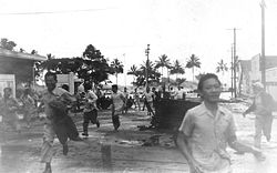
1868: Hawaiian Islands
On April 2, 1868, a local earthquake1868 Hawaii earthquake
The 1868 Hawaii earthquake is the largest recorded in the history of Hawaii island, causing a landslide and tsunami that led to 77 deaths. The earthquake occurred at 4 p.m. local time on April 2, 1868...
with a magnitude estimated between 7.5 and 8.0 rocked the southeast coast of the Big Island
Hawaii (island)
The Island of Hawaii, also called the Big Island or Hawaii Island , is a volcanic island in the North Pacific Ocean...
of Hawaii. It triggered a landslide on the slopes of the Mauna Loa
Mauna Loa
Mauna Loa is one of five volcanoes that form the Island of Hawaii in the U.S. state of Hawaii in the Pacific Ocean, and the largest on Earth in terms of volume and area covered. It is an active shield volcano, with a volume estimated at approximately , although its peak is about lower than that...
volcano, five miles (8 km) north of Pahala, killing 31 people. A tsunami then claimed 46 additional lives. The villages of Punaluu, Ninole, Kawaa, Honuapo, and Keauhou Landing were severely damaged and the village of Āpua
Apua, Hawaii
Āpua was an ancient village in the Puna district on the southern coast of the Island of Hawaii in the Hawaiian Islands. A small fishing village was located at about , an elevation about above sea level....
was destroyed. According to one account, the tsunami "rolled in over the tops of the coconut trees, probably 60 feet high .... inland a distance of a quarter of a mile in some places, taking out to sea when it returned, houses, men, women, and almost everything movable." This was reported in the 1988 edition of Walter C. Dudley's book "Tsunami!" (ISBN 0-8248-1125-9).
1868: Arica, Chile
On August 16, 1868, an earthquake1868 Arica earthquake
The 1868 Arica earthquake was an earthquake that occurred on August 13, 1868, near Arica, then part of Peru, now part of Chile, at 21:30 UTC. It had an estimated magnitude between 8.5 and 9.0...
with a magnitude estimated at 8.5 struck the oceanic trench
Oceanic trench
The oceanic trenches are hemispheric-scale long but narrow topographic depressions of the sea floor. They are also the deepest parts of the ocean floor....
currently known as the Peru-Chile Trench
Peru-Chile Trench
The Peru-Chile Trench, also known as the Atacama Trench, is an oceanic trench in the eastern Pacific Ocean, about 160 kilometres off the coast of Peru and Chile...
. A resulting tsunami struck the port of Arica
Arica, Chile
Arica is a commune and a port city with a population of 185,269 in the Arica Province of northern Chile's Arica and Parinacota Region, located only south of the border with Peru. The city is the capital of both the Arica Province and the Arica and Parinacota Region...
, then part of Peru
Peru
Peru , officially the Republic of Peru , is a country in western South America. It is bordered on the north by Ecuador and Colombia, on the east by Brazil, on the southeast by Bolivia, on the south by Chile, and on the west by the Pacific Ocean....
, killing an estimated 25,000 in Arica and 70,000 in all. Three military vessels anchored at Arica, the US
United States Navy
The United States Navy is the naval warfare service branch of the United States Armed Forces and one of the seven uniformed services of the United States. The U.S. Navy is the largest in the world; its battle fleet tonnage is greater than that of the next 13 largest navies combined. The U.S...
warship Wateree and the storeship Fredonia, and the Peruvian
Peruvian Navy
The Peruvian Navy is the branch of the Peruvian Armed Forces tasked with surveillance, patrol and defense on lakes, rivers and the Pacific Ocean up to 200 nautical miles from the Peruvian littoral...
warship America, were swept up by the tsunami.
1883: Krakatoa, Sunda Strait, Indonesia
The island volcanoVolcano
2. Bedrock3. Conduit 4. Base5. Sill6. Dike7. Layers of ash emitted by the volcano8. Flank| 9. Layers of lava emitted by the volcano10. Throat11. Parasitic cone12. Lava flow13. Vent14. Crater15...
of Krakatoa
Krakatoa
Krakatoa is a volcanic island made of a'a lava in the Sunda Strait between the islands of Java and Sumatra in Indonesia. The name is used for the island group, the main island , and the volcano as a whole. The island exploded in 1883, killing approximately 40,000 people, although some estimates...
in Indonesia
Indonesia
Indonesia , officially the Republic of Indonesia , is a country in Southeast Asia and Oceania. Indonesia is an archipelago comprising approximately 13,000 islands. It has 33 provinces with over 238 million people, and is the world's fourth most populous country. Indonesia is a republic, with an...
exploded with devastating fury on August 26–27, 1883, blowing its underground magma
Magma
Magma is a mixture of molten rock, volatiles and solids that is found beneath the surface of the Earth, and is expected to exist on other terrestrial planets. Besides molten rock, magma may also contain suspended crystals and dissolved gas and sometimes also gas bubbles. Magma often collects in...
chamber partly empty so that much overlying land and seabed collapsed into it. A series of large tsunami waves was generated from the collapse, some reaching a height of over 40 meters above sea level. Tsunami waves were observed throughout the Indian Ocean
Indian Ocean
The Indian Ocean is the third largest of the world's oceanic divisions, covering approximately 20% of the water on the Earth's surface. It is bounded on the north by the Indian Subcontinent and Arabian Peninsula ; on the west by eastern Africa; on the east by Indochina, the Sunda Islands, and...
, the Pacific Ocean
Pacific Ocean
The Pacific Ocean is the largest of the Earth's oceanic divisions. It extends from the Arctic in the north to the Southern Ocean in the south, bounded by Asia and Australia in the west, and the Americas in the east.At 165.2 million square kilometres in area, this largest division of the World...
, and even as far away as the American West Coast, and South America
South America
South America is a continent situated in the Western Hemisphere, mostly in the Southern Hemisphere, with a relatively small portion in the Northern Hemisphere. The continent is also considered a subcontinent of the Americas. It is bordered on the west by the Pacific Ocean and on the north and east...
. On the facing coasts of Java and Sumatra
Sumatra
Sumatra is an island in western Indonesia, westernmost of the Sunda Islands. It is the largest island entirely in Indonesia , and the sixth largest island in the world at 473,481 km2 with a population of 50,365,538...
the sea flood went many miles inland and caused such vast loss of life that one area was never resettled but reverted to the jungle
Jungle
A Jungle is an area of land in the tropics overgrown with dense vegetation.The word jungle originates from the Sanskrit word jangala which referred to uncultivated land. Although the Sanskrit word refers to "dry land", it has been suggested that an Anglo-Indian interpretation led to its...
and is now the Ujung Kulon nature reserve
Nature reserve
A nature reserve is a protected area of importance for wildlife, flora, fauna or features of geological or other special interest, which is reserved and managed for conservation and to provide special opportunities for study or research...
.
1896: Meiji Sanriku, Japan (明治三陸地震)
On 15 June 1896, at around 19:36 local time, a large undersea earthquake off the Sanriku coast of northeastern HonshūHonshu
is the largest island of Japan. The nation's main island, it is south of Hokkaido across the Tsugaru Strait, north of Shikoku across the Inland Sea, and northeast of Kyushu across the Kanmon Strait...
, Japan
Japan
Japan is an island nation in East Asia. Located in the Pacific Ocean, it lies to the east of the Sea of Japan, China, North Korea, South Korea and Russia, stretching from the Sea of Okhotsk in the north to the East China Sea and Taiwan in the south...
, triggered tsunami waves which struck the coast about half an hour later. Although the earthquake itself is not thought to have resulted in any fatalities, the waves, which reached a height of 100 feet (30.5 m), killed approximately 27,000 people. In 2005 the same general area was hit by the 2005 Sanriku Japan Earthquake
2005 Sanriku Japan Earthquake
The seismicity of the Sanriku coast identifies and describes the seismic activity of an area of Japan. Seismicity refers to the frequency, type and size of earthquakes experienced over a period of time...
, but with no major tsunami.
1908: Messina, Italy
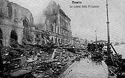
1908 Messina earthquake
The 1908 Messina earthquake and tsunami took some 100,000–200,000 lives on December 28, 1908 in Sicily and Calabria, southern Italy.-Quake:On December 28, 1908 from about 05:20 to 05:21 an earthquake of 7.2 on the moment magnitude scale occurred centered on the of city Messina, in Sicily. Reggio...
in Italy
Italy
Italy , officially the Italian Republic languages]] under the European Charter for Regional or Minority Languages. In each of these, Italy's official name is as follows:;;;;;;;;), is a unitary parliamentary republic in South-Central Europe. To the north it borders France, Switzerland, Austria and...
, triggered a large tsunami that took more than 70,000 lives.
1923: Kanto, Japan (関東大震災)
The Great Kanto Earthquake, which occurred in eastern JapanJapan
Japan is an island nation in East Asia. Located in the Pacific Ocean, it lies to the east of the Sea of Japan, China, North Korea, South Korea and Russia, stretching from the Sea of Okhotsk in the north to the East China Sea and Taiwan in the south...
on 1 September 1923, and devastated Tokyo
Tokyo
, ; officially , is one of the 47 prefectures of Japan. Tokyo is the capital of Japan, the center of the Greater Tokyo Area, and the largest metropolitan area of Japan. It is the seat of the Japanese government and the Imperial Palace, and the home of the Japanese Imperial Family...
, Yokohama
Yokohama
is the capital city of Kanagawa Prefecture and the second largest city in Japan by population after Tokyo and most populous municipality of Japan. It lies on Tokyo Bay, south of Tokyo, in the Kantō region of the main island of Honshu...
and the surrounding areas, caused tsunamis which struck the Shonan
Shonan
is the name of a region along the coast of Sagami Bay in central Japan. Centered on Enoshima, an island about 50 kilometers southwest of Tokyo, the Shōnan region stretches from Ōiso in the west to Hayama in the east, including Chigasaki, Kamakura and Hiratsuka...
coast, Boso Peninsula
Boso Peninsula
thumb|Locationthumb|Landsat image with high-resolution data from Space Shuttle is a peninsula in Chiba prefecture on Honshū, the largest island of Japan. It forms the eastern edge of Tokyo Bay, separating it from the Pacific Ocean....
, Izu Islands
Izu Islands
The are a group of volcanic islands stretching south and east from the Izu Peninsula of Honshū, Japan. Administratively, they form two towns and six villages; all part of Tokyo. The largest is Izu Ōshima, usually called simply Ōshima....
and the east coast of Izu Peninsula
Izu Peninsula
The is a large mountainous peninsula with deeply indented coasts to the west of Tokyo on the Pacific coast of the island of Honshū, Japan. Formerly the eponymous Izu Province, Izu peninsula is now a part of Shizuoka Prefecture...
, within minutes in some cases. In Atami, waves reaching 12 meters were recorded. Examples of tsunami damage include about 100 people killed along Yuigahama
Yuigahama
is a beach near Kamakura, a city in Kanagawa Prefecture, Japan. The relation between the beach and its neighboring areas is complex. Although Yuigahama is in fact the entire 3.2 km beach that goes from Inamuragasaki, which separates it from Shichirigahama, to Zaimokuza's Iijima cape, which...
beach in Kamakura
Kamakura, Kanagawa
is a city located in Kanagawa Prefecture, Japan, about south-south-west of Tokyo. It used to be also called .Although Kamakura proper is today rather small, it is often described in history books as a former de facto capital of Japan as the seat of the Shogunate and of the Regency during the...
and an estimated 50 people on the Enoshima
Enoshima
is a small island, about 4 km in circumference, at the mouth of the Katase River, which flows into Sagami Bay in Japan. Part of the city of Fujisawa, it is linked to the Katase section of the same city on the mainland by a 600 meter-long bridge...
causeway. However, tsunamis only accounted for a small proportion of the final death toll of over 100,000, most of whom were killed in fire.
1929: Newfoundland
1929 Grand Banks earthquake
The 1929 Grand Banks earthquake, also called the Laurentian Slope earthquake and the South Shore Disaster, was a magnitude 7.2 earthquake that occurred on November 18, 1929 in the Atlantic Ocean off the south coast of Newfoundland in the Laurentian Slope Seismic Zone.The earthquake was centred on...
occurred beneath the Laurentian Slope
Laurentian Slope Seismic Zone
The Laurentian Slope Seismic Zone is a seismically active area in Atlantic Canada located on the Grand Banks of Newfoundland. It was the epicenter of the magnitude 7.2 1929 Grand Banks earthquake. Since then, more than 20 relatively minor earthquakes have occurred....
on the Grand Banks
Grand Banks
The Grand Banks of Newfoundland are a group of underwater plateaus southeast of Newfoundland on the North American continental shelf. These areas are relatively shallow, ranging from in depth. The cold Labrador Current mixes with the warm waters of the Gulf Stream here.The mixing of these waters...
. The quake was felt throughout the Atlantic Provinces of Canada
Canada
Canada is a North American country consisting of ten provinces and three territories. Located in the northern part of the continent, it extends from the Atlantic Ocean in the east to the Pacific Ocean in the west, and northward into the Arctic Ocean...
and as far west as Ottawa
Ottawa
Ottawa is the capital of Canada, the second largest city in the Province of Ontario, and the fourth largest city in the country. The city is located on the south bank of the Ottawa River in the eastern portion of Southern Ontario...
and as far south as Claymont, Delaware
Claymont, Delaware
Claymont is a census-designated place in New Castle County, Delaware, United States. The population was 9,220 at the 2000 census.-History:...
. The resulting tsunami measured over 7 meters in height and took about 2½ hours to reach the Burin Peninsula
Burin Peninsula
The Burin Peninsula is a Canadian peninsula located on the south coast of the island of Newfoundland in the province of Newfoundland and Labrador....
on the south coast of Newfoundland
Newfoundland and Labrador
Newfoundland and Labrador is the easternmost province of Canada. Situated in the country's Atlantic region, it incorporates the island of Newfoundland and mainland Labrador with a combined area of . As of April 2011, the province's estimated population is 508,400...
, where 28 people lost their lives in various communities. It also snapped telegraph lines laid under the Atlantic.
1933: Showa Sanriku, Japan (昭和三陸地震)
On March 3, 1933, the SanrikuSanriku
is a historical region of Japan on the northeastern side of the island of Honshu, corresponding to today's Aomori, Iwate and parts of Miyagi Prefecture...
coast of northeastern Honshū
Honshu
is the largest island of Japan. The nation's main island, it is south of Hokkaido across the Tsugaru Strait, north of Shikoku across the Inland Sea, and northeast of Kyushu across the Kanmon Strait...
, Japan
Japan
Japan is an island nation in East Asia. Located in the Pacific Ocean, it lies to the east of the Sea of Japan, China, North Korea, South Korea and Russia, stretching from the Sea of Okhotsk in the north to the East China Sea and Taiwan in the south...
which had already suffered a devastating tsunami in 1896 (see above) was again stuck by tsunami waves as a result of an offshore magnitude 8.1 earthquake. The quake destroyed about 5,000 homes and killed 3,068 people, the vast majority as a result of tsunami waves. Especially hard hit was the coastal village of Taro (now part of Miyako city
Miyako, Iwate
is a city located in Iwate, Japan.It was founded on February 11, 1941.The city lies along the coast where the flows into the Pacific Ocean. It is connected to Morioka by an east-west train line and highway and the coastal highway also goes through the town...
) in Iwate Prefecture
Iwate Prefecture
is the second largest prefecture of Japan after Hokkaido. It is located in the Tōhoku region of Honshū island and contains the island's easternmost point. The capital is Morioka. Iwate has the lowest population density of any prefecture outside Hokkaido...
, which lost 42% of its total population and 98% of its buildings. Taro is now protected by an enormous tsunami wall, currently 10 meters in height and over 2 kilometers long. The original wall
Seawall
A seawall is a form of coastal defence constructed where the sea, and associated coastal processes, impact directly upon the landforms of the coast. The purpose of a seawall is to protect areas of human habitation, conservation and leisure activities from the action of tides and waves...
, constructed in 1958, saved Taro from destruction of the 1960 Chilean tsunami (see below). However it failed to protect Taro from the 2011 Tōhoku earthquake and tsunami
2011 Tōhoku earthquake and tsunami
The 2011 earthquake off the Pacific coast of Tohoku, also known as the 2011 Tohoku earthquake, or the Great East Japan Earthquake, was a magnitude 9.0 undersea megathrust earthquake off the coast of Japan that occurred at 14:46 JST on Friday, 11 March 2011, with the epicenter approximately east...
which inundated the village with 12–15 meters of water.
1944: Tonankai, Japan (東南海地震)
A magnitude 8.0 earthquake on 7 December 1944, about 20 km off the Shima Peninsula in JapanJapan
Japan is an island nation in East Asia. Located in the Pacific Ocean, it lies to the east of the Sea of Japan, China, North Korea, South Korea and Russia, stretching from the Sea of Okhotsk in the north to the East China Sea and Taiwan in the south...
, which struck the Pacific
Pacific Ocean
The Pacific Ocean is the largest of the Earth's oceanic divisions. It extends from the Arctic in the north to the Southern Ocean in the south, bounded by Asia and Australia in the west, and the Americas in the east.At 165.2 million square kilometres in area, this largest division of the World...
coast of central Japan, mainly Mie
Mie Prefecture
is a prefecture of Japan which is part of the Kansai regions on Honshū island. The capital is the city of Tsu.- History :Until the Meiji Restoration, Mie prefecture was known as Ise Province and Iga Province....
, Aichi
Aichi Prefecture
is a prefecture of Japan located in the Chūbu region. The region of Aichi is also known as the Tōkai region. The capital is Nagoya. It is the focus of the Chūkyō Metropolitan Area.- History :...
, and Shizuoka Prefecture
Shizuoka Prefecture
is a prefecture of Japan located in the Chūbu region on Honshu island. The capital is the city of Shizuoka.- History :Shizuoka prefecture was formed from the former Tōtōmi, Suruga and Izu provinces.The area was the home of the first Tokugawa Shogun...
s. News of the event was downplayed by the authorities in order to protect wartime
World War II
World War II, or the Second World War , was a global conflict lasting from 1939 to 1945, involving most of the world's nations—including all of the great powers—eventually forming two opposing military alliances: the Allies and the Axis...
morale
Morale
Morale, also known as esprit de corps when discussing the morale of a group, is an intangible term used to describe the capacity of people to maintain belief in an institution or a goal, or even in oneself and others...
, and as a result the full extent of the damage is not known, but the quake is estimated to have killed 1223 people, the tsunami being the leading cause of the fatalities. :ja:東南海地震
1946: Nankaidō, Japan (南海地震)
The Nankai earthquake on 21 December 1946 had a magnitude of 8.4 and hit at 4:19 [local time]. There was a catastrophic earthquake on the southwest of Japan in the Nankai TroughNankai Trough
The Nankai Trough is a submarine trough located south of Japan's island of Honshū, extending approximately 900 km offshore. In plate tectonics, the Nankai Trough marks a subduction zone that is caused by subduction of the Philippine Sea Plate beneath Japan, part of the Eurasian plate...
. It was felt almost everywhere in the central and western parts of the country. The tsunami that washed away 1451 houses and caused 1500 deaths in Japan. It was observed on tide gauges in California, Hawaii, and Peru.
The Nankai megathrust earthquakes are periodic earthquakes occurring off the southern coast of Kii Peninsula
Kii Peninsula
The is the largest peninsula on the island of Honshū in Japan. The area south of the “Central Tectonic Line” is called Nankii , and includes the most poleward living coral reefs in the world due to the presence of the warm Kuroshio Current, though these are threatened by global warming and human...
and Shikoku
Shikoku
is the smallest and least populous of the four main islands of Japan, located south of Honshū and east of the island of Kyūshū. Its ancient names include Iyo-no-futana-shima , Iyo-shima , and Futana-shima...
, Japan every 100 to 150 years. Particularly hard hit were the coastal towns of Kushimoto
Kushimoto, Wakayama
-Demographics:The population of Kushimoto is 20,618, consisting of 9,561 men and 11,057 women. There are a total of 9,397 families.-Junior high schools:*Kushimoto Junior High School*Kushimoto-Nishi Junior High School*Nishi-Mukai Junior High School...
and Kainan
Kainan, Wakayama
is a city located in Wakayama, Japan.As of 2008, the city has an estimated population of 55,763. The total area is 101.18 km².The city was founded on May 1, 1934.On April 1, 2005 the town of Shimotsu, from Kaisō District, was merged into Kainan....
on the Kii Peninsula. The quake led to more than 1400 deaths, tsunami being the leading cause. measuring 8.4.
1946: Aleutian Islands
Hawaii (island)
The Island of Hawaii, also called the Big Island or Hawaii Island , is a volcanic island in the North Pacific Ocean...
and five in Alaska
Alaska
Alaska is the largest state in the United States by area. It is situated in the northwest extremity of the North American continent, with Canada to the east, the Arctic Ocean to the north, and the Pacific Ocean to the west and south, with Russia further west across the Bering Strait...
(the lighthouse
Lighthouse
A lighthouse is a tower, building, or other type of structure designed to emit light from a system of lamps and lenses or, in older times, from a fire, and used as an aid to navigation for maritime pilots at sea or on inland waterways....
keepers at the Scotch Cap Light
Scotch Cap Light
The Scotch Cap Light is a lighthouse located on the southwest corner of Unimak Island in Alaska. It was the first station established on the outside coast of Alaska.-History:...
in the Aleutians). It resulted in the creation of a tsunami warning system
Tsunami warning system
A Tsunami warning system is used to detect tsunamis in advance and issue warnings to prevent loss of life and damage. It consists of two equally important components: a network of sensors to detect tsunamis and a communications infrastructure to issue timely alarms to permit evacuation of coastal...
known as the Pacific Tsunami Warning Center
Pacific Tsunami Warning Center
The Pacific Tsunami Warning Center is one of two tsunami warning centers that are operated by NOAA in the United States. Headquartered in Ewa Beach, Hawaii, the PTWC is part of an international tsunami warning system program and serves as the operational center for TWS of the Pacific issuing...
(PTWC), established in 1949 for Oceania
Oceania
Oceania is a region centered on the islands of the tropical Pacific Ocean. Conceptions of what constitutes Oceania range from the coral atolls and volcanic islands of the South Pacific to the entire insular region between Asia and the Americas, including Australasia and the Malay Archipelago...
countries. The tsunami is known as the April Fools Day Tsunami in Hawaii due to people thinking the warnings were an April Fools prank.
1952: Severo-Kurilsk, Kuril Islands, USSR
The November 5, 1952 tsunami killed 2,336 on the Kuril IslandsKuril Islands
The Kuril Islands , in Russia's Sakhalin Oblast region, form a volcanic archipelago that stretches approximately northeast from Hokkaidō, Japan, to Kamchatka, Russia, separating the Sea of Okhotsk from the North Pacific Ocean. There are 56 islands and many more minor rocks. It consists of Greater...
, USSR.
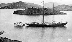
1958: Lituya Bay, Alaska, USA
On July 9, 1958, an earthquake caused a landslide which caused a megatsunamiMegatsunami
Megatsunami is an informal term to describe a tsunami that has initial wave heights that are much larger than normal tsunamis...
to reaching a height taller than the Empire State Building, measuring over 520 metres (1,706 ft), killing two.
1960: Valdivia, Chile
The magnitude-9.5 Great Chilean EarthquakeGreat Chilean Earthquake
The 1960 Valdivia earthquake or Great Chilean Earthquake of Sunday, 22 May 1960 is to date the most powerful earthquake ever recorded on Earth, rating 9.5 on the moment magnitude scale...
of May 22, 1960 is the strongest earthquake ever recorded. Its epicenter
Epicenter
The epicenter or epicentre is the point on the Earth's surface that is directly above the hypocenter or focus, the point where an earthquake or underground explosion originates...
, off the coast of South Central Chile
Chile
Chile ,officially the Republic of Chile , is a country in South America occupying a long, narrow coastal strip between the Andes mountains to the east and the Pacific Ocean to the west. It borders Peru to the north, Bolivia to the northeast, Argentina to the east, and the Drake Passage in the far...
, generated one of the most destructive tsunami of the 20th Century. It also caused a volcanic eruption.
It spread across the entire Pacific Ocean, with waves measuring up to 25 meters high. The first tsunami arrived at Hilo
Hilo, Hawai'i
Hilo is the largest census-designated place and the largest settlement on the Island of Hawaii, also known as the County of Hawaii. The population was 40,759 at the 2000 census. The population increased by 6.1% to 43,263 at the 2010 census....
approximately 14.8 hrs after it originated off the coast of South Central Chile. The highest wave at Hilo Bay was measured at around 10.7 m (35 ft). 61 lives were lost allegedly due to people's failure to heed warning sirens.
Almost 22 hours after the quake, the waves hit the ill-fated Sanriku coast of Japan, reaching up to 3 m above high tide, and killed 142 people. Up to 6,000 people died in total worldwide due to the earthquake and tsunami.
1963: Vajont Dam, Monte Toc, Italy
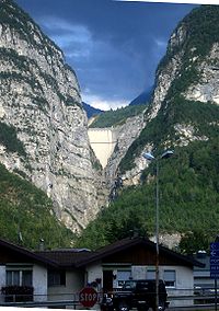
Vajont Dam
The Vajont Dam is a disused dam, completed in 1959 in the valley of the Vajont river under Monte Toc, 100 km north of Venice, Italy...
was completed in 1961 under Monte Toc
Monte Toc
Monte Toc is a mountain on the border between Veneto and Friuli-Venezia Giulia in Northern Italy best known for the Vajont Dam, which was built at the mountain's base in 1960....
, 100 km north of Venice
Venice
Venice is a city in northern Italy which is renowned for the beauty of its setting, its architecture and its artworks. It is the capital of the Veneto region...
, Italy
Italy
Italy , officially the Italian Republic languages]] under the European Charter for Regional or Minority Languages. In each of these, Italy's official name is as follows:;;;;;;;;), is a unitary parliamentary republic in South-Central Europe. To the north it borders France, Switzerland, Austria and...
. At 262 metres, it was one of the highest dams in the world. On October 9, 1963 an enormous landslide of about 260 million cubic metres of forest, earth, and rock, fell into the reservoir at up to 110 km per hour (68 mph). The resulting displacement of water caused 50 million cubic metres of water to overtop the dam in a 250-metre high megatsunami
Megatsunami
Megatsunami is an informal term to describe a tsunami that has initial wave heights that are much larger than normal tsunamis...
wave. The flooding destroyed the villages of Longarone
Longarone
Longarone is a town and comune on the banks of the Piave in the province of Belluno, in North-East Italy. It is situated 35 kilometers from Belluno....
, Pirago, Rivalta, Villanova
Villanova
Villanova may refer to:In botany:*Villanova, a genus of plants in the family Phyllanthaceae, an invalid name replaced by Flueggea, or bushweed*Villanova , a genus of plants in the family Asteraceae.In education:*St...
and Faè
FAE
The acronym FAE may refer to:In the arts:* The 'F-A-E' Sonata, jointly written by Robert Schumann, Johannes Brahms, and Albert Dietrich* First Among Equals , a 1984 novel by Jeffrey Archer...
, killing 1,450 people. Almost 2,000 people (some sources report 1,909) perished in total.
1964: Niigata, Japan (新潟地震)
The 1964 Niigata earthquake1964 Niigata earthquake
The 1964 Niigata earthquake struck at 13:01 local time on 16 June. The epicenter was on the continental shelf off the northwest coast of Honshu in Niigata Prefecture, about 50 km north of the city of Niigata...
in Japan
Japan
Japan is an island nation in East Asia. Located in the Pacific Ocean, it lies to the east of the Sea of Japan, China, North Korea, South Korea and Russia, stretching from the Sea of Okhotsk in the north to the East China Sea and Taiwan in the south...
killed 28 people, and liquefacted whole apartment buildings. A subsequent tsunami destroyed the port of Niigata
Niigata, Niigata
is the capital and the most populous city of Niigata Prefecture, Japan. It lies on the northwest coast of Honshu, the largest island of Japan, and faces the Sea of Japan and Sado Island....
city. :ja:新潟地震
1964: Alaska, USA
After the magnitude 9.2 Good Friday EarthquakeGood Friday Earthquake
The 1964 Alaska earthquake, also known as the Great Alaskan Earthquake, the Portage Earthquake and the Good Friday Earthquake, was a megathrust earthquake that began at 5:36 P.M. AST on Good Friday, March 27, 1964...
, tsunamis struck Alaska
Alaska
Alaska is the largest state in the United States by area. It is situated in the northwest extremity of the North American continent, with Canada to the east, the Arctic Ocean to the north, and the Pacific Ocean to the west and south, with Russia further west across the Bering Strait...
, British Columbia
British Columbia
British Columbia is the westernmost of Canada's provinces and is known for its natural beauty, as reflected in its Latin motto, Splendor sine occasu . Its name was chosen by Queen Victoria in 1858...
, California
California
California is a state located on the West Coast of the United States. It is by far the most populous U.S. state, and the third-largest by land area...
, and coastal Pacific Northwest
Pacific Northwest
The Pacific Northwest is a region in northwestern North America, bounded by the Pacific Ocean to the west and, loosely, by the Rocky Mountains on the east. Definitions of the region vary and there is no commonly agreed upon boundary, even among Pacific Northwesterners. A common concept of the...
towns, killing 121 people. The waves were up to 100 feet (30.5 m) tall, and killed 11 people as far away as Crescent City, California
Crescent City, California
Crescent City is the county seat and only incorporated city in Del Norte County, California. Named for the crescent-shaped stretch of sandy beach south of the city, Crescent City had a total population of 7,643 in the 2010 census, up from 4,006 in the 2000 census...
. This happened on March 27, 1964.
The incident was covered in Dennis Powers' The Raging Sea: The Powerful Account of the Worst Tsunami in U.S. History (ISBN 0806526823).
1976: Moro Gulf, Mindanao, Philippines
On August 16, 1976 at 12:11 A.M., a devastating earthquake of 7.9 hit the island of MindanaoMindanao
Mindanao is the second largest and easternmost island in the Philippines. It is also the name of one of the three island groups in the country, which consists of the island of Mindanao and smaller surrounding islands. The other two are Luzon and the Visayas. The island of Mindanao is called The...
, Philippines
Philippines
The Philippines , officially known as the Republic of the Philippines , is a country in Southeast Asia in the western Pacific Ocean. To its north across the Luzon Strait lies Taiwan. West across the South China Sea sits Vietnam...
. It created a tsunami that devastated more than 700 km of coastline bordering Moro Gulf in the North Celebes Sea. An estimated number of victims for this tragedy left 5,000 dead, 2,200 missing or presumed dead, more than 9,500 injured and a total of 93,500 people were left homeless. It devastated the cities of Cotabato
Cotabato City
The City of Cotabato is one of the cities of the Philippines located in Mindanao. Cotabato City is an exclave of the SOCCSKSARGEN region found within the boundaries of Maguindanao province, but is independent of that province...
, Pagadian
Pagadian City
The City of Pagadian is the provincial capital of Zamboanga del Sur in the island of Mindanao, Republic of the Philippines.-Overview:The city had its beginnings as a...
, and Zamboanga
Zamboanga City
The City of Zamboanga : is a highly urbanized, independent and a chartered city located in Mindanao, Philippines....
, and the and provinces of Basilan
Basilan
The Province of Basilan is an island province of the Philippines within the Autonomous Region in Muslim Mindanao . Basilan is the largest and northernmost of the major islands of the Sulu Archipelago and is located just off the southern coast of Zamboanga Peninsula...
, Lanao del Norte
Lanao del Norte
Lanao del Norte is a province of the Philippines located in the Northern Mindanao region. Its capital is Tubod. The province borders Lanao del Sur to the southeast, Zamboanga del Sur to the west, Illana Bay to the southwest, Iligan Bay to the north, Iligan City to the northeast, and is separated...
, Lanao del Sur
Lanao del Sur
Lanao del Sur is a province of the Philippines located in the Autonomous Region in Muslim Mindanao . Its capital is Marawi City and borders Lanao del Norte to the north, Bukidnon to the east, and Maguindanao and Cotabato to the south. To the southwest lies Illana Bay, an arm of the Moro Gulf...
, Maguindanao
Maguindanao
Maguindanao is a province of the Philippines located in the Autonomous Region in Muslim Mindanao . Its capital is Shariff Aguak. It borders Lanao del Sur to the north, Cotabato to the east, and Sultan Kudarat to the south....
, Sultan Kudarat, Sulu, and Zamboanga del Sur
Zamboanga del Sur
Zamboanga del Sur is a province of the Philippines located in the Zamboanga Peninsula region in Mindanao. Pagadian City is the capital...
.
1979: Tumaco, Colombia
A magnitude 7.9 earthquake occurred on December 12, 1979 at 7:59:4.3 UTC along the Pacific coast of ColombiaColombia
Colombia, officially the Republic of Colombia , is a unitary constitutional republic comprising thirty-two departments. The country is located in northwestern South America, bordered to the east by Venezuela and Brazil; to the south by Ecuador and Peru; to the north by the Caribbean Sea; to the...
and Ecuador
Ecuador
Ecuador , officially the Republic of Ecuador is a representative democratic republic in South America, bordered by Colombia on the north, Peru on the east and south, and by the Pacific Ocean to the west. It is one of only two countries in South America, along with Chile, that do not have a border...
. The earthquake and the resulting tsunami caused the destruction of at least six fishing villages and the death of hundreds of people in the Colombian Department of Nariño
Nariño Department
Nariño is a department of Colombia named after Antonio Nariño. It is in the west of the country, bordering Ecuador and the Pacific Ocean.Its capital is Pasto, other important cities include Tumaco, Ipiales.-Municipalities:# Albán# Aldana# Ancuya...
. The earthquake was felt in Bogotá
Bogotá
Bogotá, Distrito Capital , from 1991 to 2000 called Santa Fé de Bogotá, is the capital, and largest city, of Colombia. It is also designated by the national constitution as the capital of the department of Cundinamarca, even though the city of Bogotá now comprises an independent Capital district...
, Cali
Calì
Calì, also written in English as Cali, is an Italian surname, widespread mainly in the Ionian side of Sicily.For the surname Calì is assumed the origin of the Greek word kalos , or from its Sanskrit root kali, "time."The surname refers to:...
, Popayán
Popayán
Popayán is the capital of the Colombian department of Cauca. It is located in southwestern Colombia between Colombia's Western Mountain Range and Central Mountain Range...
, Buenaventura, and several other cities and towns in Colombia and in Guayaquil
Guayaquil
Guayaquil , officially Santiago de Guayaquil , is the largest and the most populous city in Ecuador,with about 2.3 million inhabitants in the city and nearly 3.1 million in the metropolitan area, as well as that nation's main port...
, Esmeraldas, Quito
Quito
San Francisco de Quito, most often called Quito , is the capital city of Ecuador in northwestern South America. It is located in north-central Ecuador in the Guayllabamba river basin, on the eastern slopes of Pichincha, an active stratovolcano in the Andes mountains...
, and other parts of Ecuador. When the tsunami hit the coast, it caused huge destruction in the city of Tumaco
Tumaco
Tumaco is a port city and municipality in the Nariño Department, Colombia, by the Pacific Ocean. It is located on the southwestern of Colombia, near to border with Ecuador, and enjoys of hot tropical climate...
, as well as in the small towns of El Charco, San Juan, Mosquera, and Salahonda on the Pacific coast of Colombia. The total number of victims of this tragedy was 259 dead, 798 wounded and 95 missing or presumed dead.
1980: Spirit Lake, Washington, USA
On May 18, 1980, the upper 460 m (1400 ft) of Mount St. Helens had failed, in the course of a major eruption of that volcano, causing a major landslide. One lobe of the landslide surged onto the nearby Spirit LakeSpirit Lake (Washington)
Spirit Lake is a lake north of Mount St. Helens in Washington State. The lake was a popular tourist destination for many years until the 1980 eruption of Mount St. Helens. With the eruption and resulting megatsunami, thousands of trees were torn from the surrounding hillside after lake water was...
, creating a megatsunami
Megatsunami
Megatsunami is an informal term to describe a tsunami that has initial wave heights that are much larger than normal tsunamis...
of 260 meters high.
1983: Sea of Japan (日本海中部地震)
On May 26, 1983 at 11:59:57 local time, a magnitude-7.7 earthquake occurred in the Sea of JapanSea of Japan
The Sea of Japan is a marginal sea of the western Pacific Ocean, between the Asian mainland, the Japanese archipelago and Sakhalin. It is bordered by Japan, North Korea, Russia and South Korea. Like the Mediterranean Sea, it has almost no tides due to its nearly complete enclosure from the Pacific...
, about 100 km west of the coast of Noshiro
Noshiro, Akita
is a city located in Akita, Japan.The city is known within Japan for the basketball team of . The city merged with the town of Futatsui on March 21, 2006 to become the new city of Noshiro. Noshiro was the site in 770 AD where Imperial Navies arrived and established Japan's first settlement in Oshu...
in Akita Prefecture
Akita Prefecture
is a prefecture of Japan located in the Tōhoku Region of northern Honshu, the main island of Japan. The capital is the city of Akita.- History :The area of Akita has been created from the ancient provinces of Dewa and Mutsu....
, Japan
Japan
Japan is an island nation in East Asia. Located in the Pacific Ocean, it lies to the east of the Sea of Japan, China, North Korea, South Korea and Russia, stretching from the Sea of Okhotsk in the north to the East China Sea and Taiwan in the south...
. Out of the 107 fatalities, all but four were killed by the resulting tsunami, which struck communities along the coast, especially Aomori
Aomori Prefecture
is a prefecture of Japan located in the Tōhoku Region. The capital is the city of Aomori.- History :Until the Meiji Restoration, the area of Aomori prefecture was known as Mutsu Province....
and Akita Prefecture
Akita Prefecture
is a prefecture of Japan located in the Tōhoku Region of northern Honshu, the main island of Japan. The capital is the city of Akita.- History :The area of Akita has been created from the ancient provinces of Dewa and Mutsu....
s and the east coast of Noto Peninsula
Noto Peninsula
thumb|right|240px|Landsat image with high-resolution data from Space Shuttle.Noto Peninsula is a peninsula that projects north into the Sea of Japan from the coast of Ishikawa prefecture in central Honshū, the main island of Japan...
. Footage of the tsunami hitting the fishing harbor of Wajima on Noto Peninsula was broadcast on TV. The waves exceeded 10 meters in some areas. Three of the fatalities were along the east coast of South Korea
South Korea
The Republic of Korea , , is a sovereign state in East Asia, located on the southern portion of the Korean Peninsula. It is neighbored by the People's Republic of China to the west, Japan to the east, North Korea to the north, and the East China Sea and Republic of China to the south...
(whether North Korea
North Korea
The Democratic People’s Republic of Korea , , is a country in East Asia, occupying the northern half of the Korean Peninsula. Its capital and largest city is Pyongyang. The Korean Demilitarized Zone serves as the buffer zone between North Korea and South Korea...
was affected is not known). The tsunami also hit Okushiri Island, the site of a more deadly tsunami 10 years later. :ja:日本海中部地震
1993: Okushiri, Hokkaido, Japan (北海道南西沖地震)
A devastating tsunami wave occurred along the coasts of HokkaidōHokkaido
, formerly known as Ezo, Yezo, Yeso, or Yesso, is Japan's second largest island; it is also the largest and northernmost of Japan's 47 prefectural-level subdivisions. The Tsugaru Strait separates Hokkaido from Honshu, although the two islands are connected by the underwater railway Seikan Tunnel...
in Japan as a result of a magnitude 7.8 earthquake, 80 miles (128.7 km) offshore, on July 12, 1993.
Within minutes, the Japan Meteorological Agency
Japan Meteorological Agency
The or JMA, is the Japanese government's weather service. Charged with gathering and reporting weather data and forecasts in Japan, it is a semi-autonomous part of the Ministry of Land, Infrastructure and Transport...
issued a tsunami warning that was broadcast on NHK
NHK
NHK is Japan's national public broadcasting organization. NHK, which has always identified itself to its audiences by the English pronunciation of its initials, is a publicly owned corporation funded by viewers' payments of a television license fee....
in English and Japanese (archived at NHK library). However, it was too late for Okushiri
Okushiri, Hokkaido
is a town encompassing all of Okushiri Island, located in Okushiri District, Hiyama, Hokkaidō, Japan.As of 2008, the town has an estimated population of 3,442 and a density of 24.5 persons per km²...
, a small island near the epicenter, which was struck with extremely big waves, some reaching 30 meters, within two to five minutes of the quake. Aonae, a village on a low-lying peninsula at the southern tip of the island, was devastated over the course of the following hour by 13 waves of over two meters’ height arriving from multiple directions, including waves that had bounced back off Hokkaidō—despite being surrounded by tsunami barriers. Of 250 people killed as a result of the quake, 197 were victims of the series of tsunamis that hit Okushiri; the waves also caused deaths on the coast of Hokkaidō. While many residents, remembering the 1983 tsunami (see above), survived by quickly evacuating on foot to higher ground, it is thought that many others underestimated how soon the waves would arrive (the 1983 tsunami took 17 minute
Minute
A minute is a unit of measurement of time or of angle. The minute is a unit of time equal to 1/60th of an hour or 60 seconds. In the UTC time scale, a minute on rare occasions has 59 or 61 seconds; see leap second. The minute is not an SI unit; however, it is accepted for use with SI units...
s to hit Okushiri) and were killed as they attempted to evacuate by car along the village’s narrow lanes. The highest wave of the tsunami was a staggering 31 meters (102 ft) high. :ja:北海道南西沖地震
1998: Papua New Guinea
On 17 July 1998, a Papua New GuineaPapua New Guinea
Papua New Guinea , officially the Independent State of Papua New Guinea, is a country in Oceania, occupying the eastern half of the island of New Guinea and numerous offshore islands...
tsunami killed approximately 2,200 people. A 7.1-magnitude earthquake 24 km offshore was followed within 11 minutes by a tsunami about 15 metres tall. The tsunami was generated by an undersea landslide
Landslide
A landslide or landslip is a geological phenomenon which includes a wide range of ground movement, such as rockfalls, deep failure of slopes and shallow debris flows, which can occur in offshore, coastal and onshore environments...
, which was triggered by the earthquake
Earthquake
An earthquake is the result of a sudden release of energy in the Earth's crust that creates seismic waves. The seismicity, seismism or seismic activity of an area refers to the frequency, type and size of earthquakes experienced over a period of time...
. The magnitude of the earthquake was too low to generate a tsunami. The villages of Arop and Warapu were destroyed.
2004: Indian Ocean
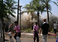
2004 Indian Ocean earthquake
The 2004 Indian Ocean earthquake was an undersea megathrust earthquake that occurred at 00:58:53 UTC on Sunday, December 26, 2004, with an epicentre off the west coast of Sumatra, Indonesia. The quake itself is known by the scientific community as the Sumatra-Andaman earthquake...
, which had a moment magnitude of 9.1–9.3, triggered a series of lethal tsunamis on December 26, 2004, that killed approximately 230,210 people (including 168,000 in Indonesia
Indonesia
Indonesia , officially the Republic of Indonesia , is a country in Southeast Asia and Oceania. Indonesia is an archipelago comprising approximately 13,000 islands. It has 33 provinces with over 238 million people, and is the world's fourth most populous country. Indonesia is a republic, with an...
alone), making it the deadliest tsunami as well as one of the deadliest natural disasters in recorded history
Recorded history
Recorded history is the period in history of the world after prehistory. It has been written down using language, or recorded using other means of communication. It starts around the 4th millennium BC, with the invention of writing.-Historical accounts:...
. It was also caused by the third largest earthquake in recorded history. The initial surge was measured at a height of approximately 33 metres (108.3 ft), making it the largest earthquake-generated tsunami in recorded history. The tsunami killed people over an area ranging from the immediate vicinity of the quake
Epicenter
The epicenter or epicentre is the point on the Earth's surface that is directly above the hypocenter or focus, the point where an earthquake or underground explosion originates...
in Indonesia, Thailand
Thailand
Thailand , officially the Kingdom of Thailand , formerly known as Siam , is a country located at the centre of the Indochina peninsula and Southeast Asia. It is bordered to the north by Burma and Laos, to the east by Laos and Cambodia, to the south by the Gulf of Thailand and Malaysia, and to the...
, and the north-western coast of Malaysia, to thousands of kilometres away in Bangladesh
Bangladesh
Bangladesh , officially the People's Republic of Bangladesh is a sovereign state located in South Asia. It is bordered by India on all sides except for a small border with Burma to the far southeast and by the Bay of Bengal to the south...
, India
India
India , officially the Republic of India , is a country in South Asia. It is the seventh-largest country by geographical area, the second-most populous country with over 1.2 billion people, and the most populous democracy in the world...
, Sri Lanka
Sri Lanka
Sri Lanka, officially the Democratic Socialist Republic of Sri Lanka is a country off the southern coast of the Indian subcontinent. Known until 1972 as Ceylon , Sri Lanka is an island surrounded by the Indian Ocean, the Gulf of Mannar and the Palk Strait, and lies in the vicinity of India and the...
, the Maldives
Maldives
The Maldives , , officially Republic of Maldives , also referred to as the Maldive Islands, is an island nation in the Indian Ocean formed by a double chain of twenty-six atolls oriented north-south off India's Lakshadweep islands, between Minicoy Island and...
, and even as far away as Somalia
Somalia
Somalia , officially the Somali Republic and formerly known as the Somali Democratic Republic under Socialist rule, is a country located in the Horn of Africa. Since the outbreak of the Somali Civil War in 1991 there has been no central government control over most of the country's territory...
, Kenya
Kenya
Kenya , officially known as the Republic of Kenya, is a country in East Africa that lies on the equator, with the Indian Ocean to its south-east...
, and Tanzania
Tanzania
The United Republic of Tanzania is a country in East Africa bordered by Kenya and Uganda to the north, Rwanda, Burundi, and the Democratic Republic of the Congo to the west, and Zambia, Malawi, and Mozambique to the south. The country's eastern borders lie on the Indian Ocean.Tanzania is a state...
in eastern Africa
Africa
Africa is the world's second largest and second most populous continent, after Asia. At about 30.2 million km² including adjacent islands, it covers 6% of the Earth's total surface area and 20.4% of the total land area...
. This trans-Indian Ocean tsunami is an example of a teletsunami
Teletsunami
A teletsunami is a tsunami that originates from a distant source, which is more than 1,000 km away from the area of interest . A teletsunami can travel across an entire ocean...
, which can travel vast distances across the open ocean. In this case, it is an ocean-wide tsunami.
Unlike in the Pacific Ocean
Pacific Ocean
The Pacific Ocean is the largest of the Earth's oceanic divisions. It extends from the Arctic in the north to the Southern Ocean in the south, bounded by Asia and Australia in the west, and the Americas in the east.At 165.2 million square kilometres in area, this largest division of the World...
, there was no organized alert service covering the Indian Ocean
Indian Ocean
The Indian Ocean is the third largest of the world's oceanic divisions, covering approximately 20% of the water on the Earth's surface. It is bounded on the north by the Indian Subcontinent and Arabian Peninsula ; on the west by eastern Africa; on the east by Indochina, the Sunda Islands, and...
. This was in part due to the absence of major tsunami events since 1883 (the Krakatoa
Krakatoa
Krakatoa is a volcanic island made of a'a lava in the Sunda Strait between the islands of Java and Sumatra in Indonesia. The name is used for the island group, the main island , and the volcano as a whole. The island exploded in 1883, killing approximately 40,000 people, although some estimates...
eruption, which killed 36,000 people). In light of the 2004 Indian Ocean tsunami, UNESCO
UNESCO
The United Nations Educational, Scientific and Cultural Organization is a specialized agency of the United Nations...
and other world bodies have called for an international tsunami monitoring system
Tsunami warning system
A Tsunami warning system is used to detect tsunamis in advance and issue warnings to prevent loss of life and damage. It consists of two equally important components: a network of sensors to detect tsunamis and a communications infrastructure to issue timely alarms to permit evacuation of coastal...
.
2006: South of Java Island
A 7.7 magnitudeMoment magnitude scale
The moment magnitude scale is used by seismologists to measure the size of earthquakes in terms of the energy released. The magnitude is based on the seismic moment of the earthquake, which is equal to the rigidity of the Earth multiplied by the average amount of slip on the fault and the size of...
earthquake rocked the Indian Ocean seabed on July 17, 2006, 200 km south of Pangandaran
Pangandaran
Pangandaran is a small town and a subdistrict in southern Ciamis regency, West Java, Indonesia. It is located on the southern coast of Java. Pangandaran is a popular tourist destination, having a beach which is considered to be one of the finest in Java and which offers excellent surfing.A...
, a beautiful beach famous to surfers for its perfect waves. This earthquake triggered tsunamis which height varied from 2 meters at Cilacap
Cilacap
Cilacap is a regency in the southwestern part of Central Java province in Indonesia. Its capital is Cilacap, which is an municipality in its own right....
to 6 meters at Cimerak beach, where it swept away and flattened buildings as far as 400 meters away from the coastline. More than 800 people were reported missing or dead.
2006: Kuril Islands
On 15 November 2006, a magnitude 8.3 earthquake occurred off the coast near the Kuril Islands. In spite of the quake's large 8.3 magnitude, a relatively small tsunami was generated. The small tsunami was recorded or observed in Japan and at distant locations throughout the Pacific.2007: Solomon Islands
On April 24, 2007, a powerful magnitude 8.1 (initially 7.6) earthquake hit the East Pacific region about 40 km (24.9 mi), south of Ghizo Island in the western Solomon IslandsSolomon Islands
Solomon Islands is a sovereign state in Oceania, east of Papua New Guinea, consisting of nearly one thousand islands. It covers a land mass of . The capital, Honiara, is located on the island of Guadalcanal...
at 7:39 a.m., resulting in a tsunami that was up to 12 m (36 feet) tall. The wave, which struck the coast of Solomon Islands (mainly Choiseul
Choiseul
-People:*Choiseul . Holders include:-** Caesar, duc de Choiseul , French marshal and diplomat, generally known for the best part of his life as marshal du Plessis-Praslin** Claude de Choiseul , marshal of France in 1693...
, Ghizo Island, Ranongga
Ranongga
Ranongga is an island located in the New Georgia Islands group of Western Province, Solomon Islands.-History:Ranongga was sighted in 1787 by sailors Read and Dale....
, and Simbo
Simbo
Simbo is an island in the Solomon Islands; it is located in the Western Province. It was known to early Europeans as Eddystone Island. Simbo is actually two main islands, one small island called Nusa Simbo separated by a saltwater lagoon from a larger one...
), triggered region-wide tsunami warnings and watches extending from Japan to New Zealand to Hawaii and the eastern seaboard of Australia. The tsunami that followed the earthquake killed 52 people. Dozens more have been injured with entire towns inundated by the sweeping water which traveled 300 meters inland in some places. A state of national emergency was declared for the Solomon Islands. On the island of Choiseul
Choiseul
-People:*Choiseul . Holders include:-** Caesar, duc de Choiseul , French marshal and diplomat, generally known for the best part of his life as marshal du Plessis-Praslin** Claude de Choiseul , marshal of France in 1693...
, a wall of water reported to be 9.1 m (30 feet) high swept almost 400 meters inland destroying everything in its path. The largest waves hit the northern tip of Simbo
Simbo
Simbo is an island in the Solomon Islands; it is located in the Western Province. It was known to early Europeans as Eddystone Island. Simbo is actually two main islands, one small island called Nusa Simbo separated by a saltwater lagoon from a larger one...
Island. There two villages, Tapurai and Riquru, were completely destroyed by a 12 m wave, killing 10 people. Officials estimate that the tsunami displaced more than 5000 residents all over the archipelago.
2007: Niigata, Japan (新潟県中越沖地震)
On 16 July 2007, a strong earthquake struck northwestern Japan, causing a fire and minor radioactive water leak at one of the world's most powerful nuclear power plants. At least seven people were killed and hundreds injured. Japan's Meteorological Agency measured the quake at 6.8 on the richter scale and sending aftershocks of 6.6. The U.S. Geological Survey, which monitors quakes around the world, said the initial quake registered 6.7. A tsunami watch was issued along the Sea of Japan. The predicted height of the tsunami was estimated to be 50 cm (20 inches). That earthquake sparked only a few small tsunamis, growing to be no more than about 20 cm (8 inches) tall. However, the 1964 quake and tsunami north of the current one destroyed the port of the city of NiigataNiigata, Niigata
is the capital and the most populous city of Niigata Prefecture, Japan. It lies on the northwest coast of Honshu, the largest island of Japan, and faces the Sea of Japan and Sado Island....
. :ja:新潟県中越沖地震
2009: Samoa
The 2009 Samoa earthquake was an 8.1 Mw submarine earthquake that took place in the Samoan Islands region at 06:48:11 local time on September 29, 2009 (17:48:11 UTC, September 29).[3] At a magnitude of 8.1, it was the largest earthquake of 2009.A tsunami was generated which caused substantial damage and loss of life in Samoa, American Samoa, and Tonga. The Pacific Tsunami Warning Center recorded a 3-inch (76 mm) rise in sea levels near the epicenter, and New Zealand scientists determined that the waves measured 14 metres (46 ft) at their highest on the Samoan coast.[4] The quake occurred on the outer rise of the Kermadec-Tonga Subduction Zone. This is part of the Pacific Ring of Fire, where tectonic plates in the Earth's lithosphere meet and earthquakes and volcanic activity are common.
Countries affected by the tsunami in the areas that were hit are American Samoa, Samoa and Tonga (Niuatoputapu) where more than 189 people were killed, especially children, most of them in Samoa.[5] Large waves with no major damage were reported on the coasts of Fiji, the northern coast of New Zealand[6] and Rarotonga in the Cook Islands. People took precautions in the low-lying atolls of Tokelau and moved to higher ground. Niue was reported as reasonably safe because it is high. There were no reports of high waves from Vanuatu, Kiribati, New Caledonia and the Solomon Islands.[7]
2010: Chile
The seismic event in the southern Pacific produced waves measuring 1.8–9 meters along the Sanriku Coastline of northeastern HonshuHonshu
is the largest island of Japan. The nation's main island, it is south of Hokkaido across the Tsugaru Strait, north of Shikoku across the Inland Sea, and northeast of Kyushu across the Kanmon Strait...
in Japan.
2011: New Zealand
On February 22, 2011, a 6.3 magnitude earthquake hit the Canterbury Region of the South Island, New Zealand. Some 200 kilometres (124.3 mi) away from the earthquake's epicenter, around 30 million tonnes of ice tumbled off the Tasman GlacierTasman Glacier
The Tasman Glacier is the largest of several glaciers which flow south and east towards the Mackenzie Basin from the Southern Alps in New Zealand's South Island. It is New Zealand's longest glacier.-Geography:...
into Tasman Lake
Tasman Lake
Tasman Lake is a proglacial lake formed by the recent retreat of the Tasman Glacier in New Zealand's South Island.In the early 1970s, there were several small meltwater ponds on the Tasman Glacier. By 1990, these ponds had merged into Tasman Lake....
, producing a series of 3.5 m (11 ft) high tsunami waves, which hit tourist boats in the lake.
2011: Pacific coast of Japan
On March 11, 2011, off the Pacific coastPacific Coast
A country's Pacific coast is the part of its coast bordering the Pacific Ocean.-The Americas:Countries on the western side of the Americas have a Pacific coast as their western border.* Geography of Canada* Geography of Chile* Geography of Colombia...
of Japan, a 9.0 magnitude earthquake produced a tsunami 33 feet (10.1 m) high along Japan's northeastern coast. The wave caused widespread devastation, with an official count of around 20,000 people confirmed to be killed/missing. The highest tsunami which was recorded at Ryōri Bay, Ōfunato, reached a total height of 97 feet (29.6 m). In addition the tsunami precipitated multiple hydrogen explosions and nuclear meltdown
Nuclear meltdown
Nuclear meltdown is an informal term for a severe nuclear reactor accident that results in core damage from overheating. The term is not officially defined by the International Atomic Energy Agency or by the U.S. Nuclear Regulatory Commission...
at the Fukushima I Nuclear Power Plant
Fukushima I Nuclear Power Plant
The , also known as Fukushima Dai-ichi , is a disabled nuclear power plant located on a site in the towns of Okuma and Futaba in the Futaba District of Fukushima Prefecture, Japan. First commissioned in 1971, the plant consists of six boiling water reactors...
. Tsunami warnings were issued to the entire Pacific Rim
Pacific Rim
The Pacific Rim refers to places around the edge of the Pacific Ocean. The term "Pacific Basin" includes the Pacific Rim and islands in the Pacific Ocean...
.
Highest or tallest
- The tallest tsunamiTsunamiA tsunami is a series of water waves caused by the displacement of a large volume of a body of water, typically an ocean or a large lake...
ever recorded so far is the 1958 Lituya Bay megatsunami1958 Lituya Bay megatsunamiThe 1958 Lituya Bay megatsunami occurred on July 9, 1958, when an earthquake triggered a landslide that caused 30 million cubic meters of rock and ice to fall into the narrow inlet of Lituya Bay, Alaska...
, which had a record height of 524 m (1742 ft). - The only other recent megatsunamiMegatsunamiMegatsunami is an informal term to describe a tsunami that has initial wave heights that are much larger than normal tsunamis...
s are the 1980 Spirit Lake megatsunamiMegatsunamiMegatsunami is an informal term to describe a tsunami that has initial wave heights that are much larger than normal tsunamis...
, which measured 260 m (780 ft) tall and the 1963 Vajont Dam megatsunami which had an initial height of 250 m (750 ft)
Deadliest
The deadliest tsunamiTsunami
A tsunami is a series of water waves caused by the displacement of a large volume of a body of water, typically an ocean or a large lake...
in recorded history
Recorded history
Recorded history is the period in history of the world after prehistory. It has been written down using language, or recorded using other means of communication. It starts around the 4th millennium BC, with the invention of writing.-Historical accounts:...
was the 2004 Asian tsunami
2004 Indian Ocean earthquake
The 2004 Indian Ocean earthquake was an undersea megathrust earthquake that occurred at 00:58:53 UTC on Sunday, December 26, 2004, with an epicentre off the west coast of Sumatra, Indonesia. The quake itself is known by the scientific community as the Sumatra-Andaman earthquake...
, which killed almost 230,000 people in eleven countries across the Indian Ocean
Indian Ocean
The Indian Ocean is the third largest of the world's oceanic divisions, covering approximately 20% of the water on the Earth's surface. It is bounded on the north by the Indian Subcontinent and Arabian Peninsula ; on the west by eastern Africa; on the east by Indochina, the Sunda Islands, and...
.
Other historic tsunamis
Other tsunamis that have occurred include the following:- ca. 500 BC: Poompuhar, Tamil NaduTamil NaduTamil Nadu is one of the 28 states of India. Its capital and largest city is Chennai. Tamil Nadu lies in the southernmost part of the Indian Peninsula and is bordered by the union territory of Pondicherry, and the states of Kerala, Karnataka, and Andhra Pradesh...
, IndiaIndiaIndia , officially the Republic of India , is a country in South Asia. It is the seventh-largest country by geographical area, the second-most populous country with over 1.2 billion people, and the most populous democracy in the world...
, MaldivesMaldivesThe Maldives , , officially Republic of Maldives , also referred to as the Maldive Islands, is an island nation in the Indian Ocean formed by a double chain of twenty-six atolls oriented north-south off India's Lakshadweep islands, between Minicoy Island and... - 1541: a tsunami struck the earliest European settlement in Brazil, São VicenteSão Vicente, São PauloSão Vicente is a coastal city of southern São Paulo, Brazil. Its estimated population in 2006 was 329,370 inhabitants.It was the first Portuguese permanent settlement in the Americas and the first capital of the Captaincy of São Vicente, now the state of São Paulo...
. There is no record of deaths or injuries, but the town was almost completely destroyed.
South Asia
| Tsunamis in South Asia South Asia South Asia, also known as Southern Asia, is the southern region of the Asian continent, which comprises the sub-Himalayan countries and, for some authorities , also includes the adjoining countries to the west and the east... Source: Amateur Seismic Centre, India |
||||||
|---|---|---|---|---|---|---|
| Date | Location | |||||
| 1524 | Near Dabhol Dabhol Dabhol is a small seaport town in the Ratnagiri district of Maharashtra in India. •- History :Hardly a trace remains of the once-flourishing port of Dabhol , on the north bank of the mouth of the Vashishti River in the Konkan region of India.In the 15th and 16th C., Dabul was an opulent Muslim trade... , Maharashtra Maharashtra Maharashtra is a state located in India. It is the second most populous after Uttar Pradesh and third largest state by area in India... |
|||||
| 2 April 1762 | Arakan Coast, Myanmar Myanmar Burma , officially the Republic of the Union of Myanmar , is a country in Southeast Asia. Burma is bordered by China on the northeast, Laos on the east, Thailand on the southeast, Bangladesh on the west, India on the northwest, the Bay of Bengal to the southwest, and the Andaman Sea on the south.... |
|||||
| 16 June 1819 | Rann of Kachchh, Gujarat, India India India , officially the Republic of India , is a country in South Asia. It is the seventh-largest country by geographical area, the second-most populous country with over 1.2 billion people, and the most populous democracy in the world... |
|||||
| 31 October 1847 | Great Nicobar Great Nicobar Great Nicobar is the largest of the Nicobar Islands of India, north of Sumatra. Indira Point, its southernmost tip, is also the southernmost point of India. The island of Sumatra is located to the south of Great Nicobar... Island, India |
|||||
| 31 December 1881 | Car Nicobar Island, India 1881 Nicobar Islands earthquake The 1881 Nicobar Islands earthquake occurred at about 07:49 local time on 31 December, with an epicentre beneath Car Nicobar. It occurred as two separate ruptures, the largest of which had an estimated magnitude of 7.9 on the moment magnitude scale and triggered a tsunami that was observed around... |
|||||
| 26 August 1883 | Krakatoa Krakatoa Krakatoa is a volcanic island made of a'a lava in the Sunda Strait between the islands of Java and Sumatra in Indonesia. The name is used for the island group, the main island , and the volcano as a whole. The island exploded in 1883, killing approximately 40,000 people, although some estimates... , Sunda Strait Sunda Strait The Sunda Strait is the strait between the Indonesian islands of Java and Sumatra. It connects the Java Sea to the Indian Ocean... , Indonesia Indonesia Indonesia , officially the Republic of Indonesia , is a country in Southeast Asia and Oceania. Indonesia is an archipelago comprising approximately 13,000 islands. It has 33 provinces with over 238 million people, and is the world's fourth most populous country. Indonesia is a republic, with an... |
|||||
| 28 November 1945 | Mekran coast, Balochistan | |||||
North America and the Caribbean
- 1690 - NevisNevisNevis is an island in the Caribbean Sea, located near the northern end of the Lesser Antilles archipelago, about 350 km east-southeast of Puerto Rico and 80 km west of Antigua. The 93 km² island is part of the inner arc of the Leeward Islands chain of the West Indies...
- 14 November 1840 - Great Swell on the Delaware RiverDelaware RiverThe Delaware River is a major river on the Atlantic coast of the United States.A Dutch expedition led by Henry Hudson in 1609 first mapped the river. The river was christened the South River in the New Netherland colony that followed, in contrast to the North River, as the Hudson River was then...
- 18 November 1867 - Virgin IslandsVirgin IslandsThe Virgin Islands are the western island group of the Leeward Islands, which are the northern part of the Lesser Antilles, which form the border between the Caribbean Sea and the Atlantic Ocean...
- 17 November 1872 - MaineMaineMaine is a state in the New England region of the northeastern United States, bordered by the Atlantic Ocean to the east and south, New Hampshire to the west, and the Canadian provinces of Quebec to the northwest and New Brunswick to the northeast. Maine is both the northernmost and easternmost...
- 11 October 1918 - Puerto RicoPuerto RicoPuerto Rico , officially the Commonwealth of Puerto Rico , is an unincorporated territory of the United States, located in the northeastern Caribbean, east of the Dominican Republic and west of both the United States Virgin Islands and the British Virgin Islands.Puerto Rico comprises an...
- 9 January 1926 - MaineMaineMaine is a state in the New England region of the northeastern United States, bordered by the Atlantic Ocean to the east and south, New Hampshire to the west, and the Canadian provinces of Quebec to the northwest and New Brunswick to the northeast. Maine is both the northernmost and easternmost...
- 4 August 1946 - Dominican RepublicDominican RepublicThe Dominican Republic is a nation on the island of La Hispaniola, part of the Greater Antilles archipelago in the Caribbean region. The western third of the island is occupied by the nation of Haiti, making Hispaniola one of two Caribbean islands that are shared by two countries...
- 18 August 1946 - Dominican RepublicDominican RepublicThe Dominican Republic is a nation on the island of La Hispaniola, part of the Greater Antilles archipelago in the Caribbean region. The western third of the island is occupied by the nation of Haiti, making Hispaniola one of two Caribbean islands that are shared by two countries...
- 15 November 2006 - Crescent CityCrescent City, CaliforniaCrescent City is the county seat and only incorporated city in Del Norte County, California. Named for the crescent-shaped stretch of sandy beach south of the city, Crescent City had a total population of 7,643 in the 2010 census, up from 4,006 in the 2000 census...
, CACaliforniaCalifornia is a state located on the West Coast of the United States. It is by far the most populous U.S. state, and the third-largest by land area...
Possible
- 35 million years ago - Chesapeake Bay impact craterChesapeake Bay impact craterThe Chesapeake Bay impact crater was formed by a bolide that impacted the eastern shore of North America about 35 million years ago, in the late Eocene epoch. It is one of the best-preserved "wet-target" or marine impact craters, and the largest known impact crater in the U.S...
, Chesapeake BayChesapeake BayThe Chesapeake Bay is the largest estuary in the United States. It lies off the Atlantic Ocean, surrounded by Maryland and Virginia. The Chesapeake Bay's drainage basin covers in the District of Columbia and parts of six states: New York, Pennsylvania, Delaware, Maryland, Virginia, and West... - 9 June 1913 - Longport, NJNew JerseyNew Jersey is a state in the Northeastern and Middle Atlantic regions of the United States. , its population was 8,791,894. It is bordered on the north and east by the state of New York, on the southeast and south by the Atlantic Ocean, on the west by Pennsylvania and on the southwest by Delaware...
- 6 August 1923 - Rockaway Park, QueensQueensQueens is the easternmost of the five boroughs of New York City. The largest borough in area and the second-largest in population, it is coextensive with Queens County, an administrative division of New York state, in the United States....
, NYNew YorkNew York is a state in the Northeastern region of the United States. It is the nation's third most populous state. New York is bordered by New Jersey and Pennsylvania to the south, and by Connecticut, Massachusetts and Vermont to the east...
. - 8 August 1924 - Coney IslandConey IslandConey Island is a peninsula and beach on the Atlantic Ocean in southern Brooklyn, New York, United States. The site was formerly an outer barrier island, but became partially connected to the mainland by landfill....
, NYNew YorkNew York is a state in the Northeastern region of the United States. It is the nation's third most populous state. New York is bordered by New Jersey and Pennsylvania to the south, and by Connecticut, Massachusetts and Vermont to the east...
. - 19 August 1931 - Atlantic City, NJNew JerseyNew Jersey is a state in the Northeastern and Middle Atlantic regions of the United States. , its population was 8,791,894. It is bordered on the north and east by the state of New York, on the southeast and south by the Atlantic Ocean, on the west by Pennsylvania and on the southwest by Delaware...
- 22 June 1932 - CuyutlánCuyutlánCuyutlán is a town in the Mexican state of Colima, on the Pacific Ocean. Cuyutlán belongs to the municipality of Armería. There is also a Lagoon of Cuyutlán, which belongs to Armería and Manzanillo, the main Mexican harbour on the Pacific Ocean. Sea salt is produced there and has been since pre...
, ColimaColimaColima is one of the 31 states which, with the Federal District, make up the 32 Federal Entities of Mexico. It shares its name with its capital and main city, Colima....
, MexicoMexicoThe United Mexican States , commonly known as Mexico , is a federal constitutional republic in North America. It is bordered on the north by the United States; on the south and west by the Pacific Ocean; on the southeast by Guatemala, Belize, and the Caribbean Sea; and on the east by the Gulf of... - 19 May 1964 - Northeast USAUnited StatesThe United States of America is a federal constitutional republic comprising fifty states and a federal district...
- 4 July 1992 - Daytona Beach, FLFloridaFlorida is a state in the southeastern United States, located on the nation's Atlantic and Gulf coasts. It is bordered to the west by the Gulf of Mexico, to the north by Alabama and Georgia and to the east by the Atlantic Ocean. With a population of 18,801,310 as measured by the 2010 census, it...
Source: NOAA National Weather Service Forecast Office,
Europe
- 6100 BC - Storegga SlideStoregga SlideThe three Storegga Slides are considered to be amongst the largest known landslides. They occurred under water, at the edge of Norway's continental shelf , in the Norwegian Sea, 100 km north-west of the Møre coast, causing a very large tsunami in the North Atlantic Ocean...
, NorwayNorwayNorway , officially the Kingdom of Norway, is a Nordic unitary constitutional monarchy whose territory comprises the western portion of the Scandinavian Peninsula, Jan Mayen, and the Arctic archipelago of Svalbard and Bouvet Island. Norway has a total area of and a population of about 4.9 million...
- The Storegga slide generated a huge tsunami that washed through the North Atlantic Ocean, hitting NorwayNorwayNorway , officially the Kingdom of Norway, is a Nordic unitary constitutional monarchy whose territory comprises the western portion of the Scandinavian Peninsula, Jan Mayen, and the Arctic archipelago of Svalbard and Bouvet Island. Norway has a total area of and a population of about 4.9 million...
, IcelandIcelandIceland , described as the Republic of Iceland, is a Nordic and European island country in the North Atlantic Ocean, on the Mid-Atlantic Ridge. Iceland also refers to the main island of the country, which contains almost all the population and almost all the land area. The country has a population...
and the east coast of ScotlandScotlandScotland is a country that is part of the United Kingdom. Occupying the northern third of the island of Great Britain, it shares a border with England to the south and is bounded by the North Sea to the east, the Atlantic Ocean to the north and west, and the North Channel and Irish Sea to the...
, where it reached a height of 21 metres, and even washed over some of the Shetland IslandsShetland IslandsShetland is a subarctic archipelago of Scotland that lies north and east of mainland Great Britain. The islands lie some to the northeast of Orkney and southeast of the Faroe Islands and form part of the division between the Atlantic Ocean to the west and the North Sea to the east. The total...
. - 11 January 1683 - An earthquake in ItalyItalyItaly , officially the Italian Republic languages]] under the European Charter for Regional or Minority Languages. In each of these, Italy's official name is as follows:;;;;;;;;), is a unitary parliamentary republic in South-Central Europe. To the north it borders France, Switzerland, Austria and...
triggered a tsunami that killed more than 1000 people. - 6 February 1783 - An offshore earthquake1783 Calabrian earthquakesThe 1783 Calabrian earthquakes were a sequence of five strong earthquakes that hit the region of Calabria in southern Italy , the first two of which produced significant tsunamis. The epicenters form a clear alignment extending nearly 100 km from the Straits of Messina to about 18 km SSW...
in Southern Italy caused a tsunami that killed around 1500 people. - 20 September 1867 - An earthquake in GreeceGreeceGreece , officially the Hellenic Republic , and historically Hellas or the Republic of Greece in English, is a country in southeastern Europe....
caused a tsunami that killed 12 people. - 11 September 1930 - 2 people were killed by a tsunami in Italy, caused by an undersea earthquake measuring 7.7 on the Richter Scale.
- 9 July 1956 - An earthquake in Greece generated a tsunami that drowned 4 people.
- 28 February 1969 - A submarine earthquake measuring 7.3 on the Richter Scale, with its epicentre of the coast of PortugalPortugalPortugal , officially the Portuguese Republic is a country situated in southwestern Europe on the Iberian Peninsula. Portugal is the westernmost country of Europe, and is bordered by the Atlantic Ocean to the West and South and by Spain to the North and East. The Atlantic archipelagos of the...
, caused a tsunami that hit Northern Portugal, parts of SpainSpainSpain , officially the Kingdom of Spain languages]] under the European Charter for Regional or Minority Languages. In each of these, Spain's official name is as follows:;;;;;;), is a country and member state of the European Union located in southwestern Europe on the Iberian Peninsula...
, and MoroccoMoroccoMorocco , officially the Kingdom of Morocco , is a country located in North Africa. It has a population of more than 32 million and an area of 710,850 km², and also primarily administers the disputed region of the Western Sahara...
. No lives were lost. - 16 October 1979 - 23 people died when the coast of NiceNiceNice is the fifth most populous city in France, after Paris, Marseille, Lyon and Toulouse, with a population of 348,721 within its administrative limits on a land area of . The urban area of Nice extends beyond the administrative city limits with a population of more than 955,000 on an area of...
, FranceFranceThe French Republic , The French Republic , The French Republic , (commonly known as France , is a unitary semi-presidential republic in Western Europe with several overseas territories and islands located on other continents and in the Indian, Pacific, and Atlantic oceans. Metropolitan France...
, was hit by a tsunami, caused by an undersea landslide. The sea suddenly receded from the shore and returned in two huge waves, hitting a 36 miles (57.9 km)-long coastal stretch. Hundreds of boats were overturned, and 11 people working in a shipyard were drowned. - 13 December 1990 - 6 people died when an undersea earthquake in Italy caused a tsunami.
Possible
- ≈43 BC: a massive and widespread oceanic flood with large-scale destruction was reported by multiple ancient writers for the Western MediterraneanMediterranean SeaThe Mediterranean Sea is a sea connected to the Atlantic Ocean surrounded by the Mediterranean region and almost completely enclosed by land: on the north by Anatolia and Europe, on the south by North Africa, and on the east by the Levant...
regions of the Tyrrhenian CoastTyrrhenian SeaThe Tyrrhenian Sea is part of the Mediterranean Sea off the western coast of Italy.-Geography:The sea is bounded by Corsica and Sardinia , Tuscany, Lazio, Campania, Basilicata and Calabria and Sicily ....
, most notably near OstiaOstia AnticaOstia Antica is a large archeological site, close to the modern suburb of Ostia , that was the location of the harbour city of ancient Rome, which is approximately 30 km to the northeast. "Ostia" in Latin means "mouth". At the mouth of the River Tiber, Ostia was Rome's seaport, but, due to...
, and for GibraltarStrait of GibraltarThe Strait of Gibraltar is a narrow strait that connects the Atlantic Ocean to the Mediterranean Sea and separates Spain in Europe from Morocco in Africa. The name comes from Gibraltar, which in turn originates from the Arabic Jebel Tariq , albeit the Arab name for the Strait is Bab el-Zakat or...
and the Atlas regionTell AtlasThe Tell Atlas is a mountain chain over 1,500 kilometers in length, belonging to the Atlas mountain ranges in North Africa, stretching from Morocco, through Algeria to Tunisia. It parallels the Mediterranean coast...
, while the possible tsunami also created a flood of the Tiber in the city of RomeRomeRome is the capital of Italy and the country's largest and most populated city and comune, with over 2.7 million residents in . The city is located in the central-western portion of the Italian Peninsula, on the Tiber River within the Lazio region of Italy.Rome's history spans two and a half...
. - The 1607 Bristol Channel floods, which were traditionally believed to be a massive storm surge, could possibly have been a tsunami, caused by an earthquake or landslide off the coast of Southern IrelandSouthern IrelandSouthern Ireland was a short-lived autonomous region of the United Kingdom established on 3 May 1921 and dissolved on 6 December 1922.Southern Ireland was established under the Government of Ireland Act 1920 together with its sister region, Northern Ireland...
. There is some evidence suggesting it was a tsunami, but not enough to confirm. It was the deadliest natural disaster in the history of the United KingdomUnited KingdomThe United Kingdom of Great Britain and Northern IrelandIn the United Kingdom and Dependencies, other languages have been officially recognised as legitimate autochthonous languages under the European Charter for Regional or Minority Languages...
, and killed around 2000 people from SomersetSomersetThe ceremonial and non-metropolitan county of Somerset in South West England borders Bristol and Gloucestershire to the north, Wiltshire to the east, Dorset to the south-east, and Devon to the south-west. It is partly bounded to the north and west by the Bristol Channel and the estuary of the...
to CardiffCardiffCardiff is the capital, largest city and most populous county of Wales and the 10th largest city in the United Kingdom. The city is Wales' chief commercial centre, the base for most national cultural and sporting institutions, the Welsh national media, and the seat of the National Assembly for...
.
Asia
- 17 August 1999 - The 1999 İzmit earthquake1999 Izmit earthquakeThe 1999 İzmit earthquake was a 7.6 magnitude earthquake that struck northwestern Turkey on August 17, 1999, at about 3:02am local time. The event lasted for 37 seconds, killing around 17,000 people and leaving approximately half a million people homeless...
in Northwest TurkeyTurkeyTurkey , known officially as the Republic of Turkey , is a Eurasian country located in Western Asia and in East Thrace in Southeastern Europe...
triggered a 2 metre high tsunami in the Sea of MarmaraSea of MarmaraThe Sea of Marmara , also known as the Sea of Marmora or the Marmara Sea, and in the context of classical antiquity as the Propontis , is the inland sea that connects the Black Sea to the Aegean Sea, thus separating Turkey's Asian and European parts. The Bosphorus strait connects it to the Black...
and reached the Asian shore of Turkey.
See also
- TsunamiTsunamiA tsunami is a series of water waves caused by the displacement of a large volume of a body of water, typically an ocean or a large lake...
- Tsunamis in the United KingdomTsunamis in the United KingdomTsunamis affecting the British Isles are rare, and there have only been two confirmed cases in recorded history. However, meteotsunamis are somewhat more common, especially on the southern coasts of England around the English and Bristol Channels....
- List of deadly earthquakes since 1900
- List of earthquakes
- List of natural disasters by death toll
External links
- Tinti S., Maramai A., Graziani L. (2007). The Italian Tsunami Catalogue (ITC), Version 2 (Windows software database)