

Aomori Prefecture
Encyclopedia
is a prefecture
of Japan
located in the Tōhoku Region
. The capital is the city of Aomori
.
, the area of Aomori prefecture was known as Mutsu Province
.
The prefecture came into existence in 1871. Aomori Town was established in 1889. The town was incorporated as a city in 1898 with a population of 28,000. On May 3, 1910 a fire broke out in the Yasukata district. Fanned by strong winds, the fire quickly devastated the whole city. The conflagration claimed 26 lives and injured a further 160 residents. It destroyed 5,246 houses and burnt 19 storage sheds and 157 warehouses. At 10:30 p.m. on July 28, 1945 a squadron of American B29 bomber
s bombed over 90% of the city.
Radio Aomori (RAB) made its first broadcast in 1951. Four years later, the first fish auction
s were held. 1958 saw the completion of the Municipal Fish Market as well as the opening of the Citizen's Hospital. In the same year, the Tsugaru Line established a rail connection with Minmaya Village at the tip of the peninsula.
Various outlying towns and villages were incorporated into the growing city and with the absorption of Nonai Village in 1962, Aomori became the largest city in the prefecture.
In March 1985, after 23 years of labor and a financial investment of 700 billion yen, the Seikan Tunnel
finally linked the islands of Honshū
and Hokkaidō
, thereby becoming the longest tunnel of its kind in the world. Almost exactly three years later, on March 13, railroad service was inaugurated on the Tsugaru Kaikyo Line.
That same day saw the end of the Seikan Ferry
service. During their 80 years of service, the familiar ferries of the Seikan line sailed between Aomori and Hakodate some 720,000 times, carrying 160 million passengers.
In April 1993, Aomori Public College
opened. In August 1994, Aomori City made an "Education, Culture and Friendship Exchange Pact" with Kecskemet
in Hungary
. One year later a similar treaty was signed with Pyongtaek in South Korea, and cultural exchange activities began with exchanges of woodblock print
s and paintings.
In April 1995, Aomori Airport
began offering regular international air service to Seoul, South Korea, and Khabarovsk, Russia.
In June 2007, four North Korean defectors
reached Aomori Prefecture, after having been at sea for six days, marking the second known case ever where defectors have successfully reached Japan by boat.
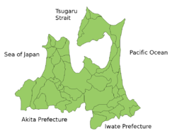
 Aomori Prefecture is the northernmost prefecture
on Honshū
and faces Hokkaidō
across the Tsugaru Strait
. It borders Akita
and Iwate
in the south. Oma
, at the northwestern tip of the axe-shaped Shimokita Peninsula
, is the northernmost point of Honshū. The Shimokita
and Tsugaru Peninsula
s enclose Mutsu Bay
. Between those peninsulas lies the Natsudomari Peninsula, the northern end of the Ōu Mountains
. The three peninsulas are prominently visible in the prefecture's symbol, a stylized map.
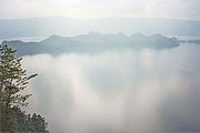
Lake Towada
, a crater
lake, straddles Aomori's boundary with Akita.

 These are the towns and villages in each district
.
, the only combined, joint U.S. service installation in the western Pacific servicing Army
, Navy
, and Air Force
, as well as the Japan Self-Defense Forces
.
, the Aomori region remains dominated by traditional industries such as farming, forestry, and fishing.
or Sendai
, looking for jobs, entertainment, and husbands. Aomori records its population as having peaked in 1983.
, a virtuosic style of shamisen
playing.
 Aomori is especially famous for its apple
orchards.
Lake Towada
, a caldera
, lies on the boundary between Akita
and Aomori Prefectures. The Oirase river
drains Lake Towada; in the summer it is refreshing and in the autumn the leaves are breathtaking.
Mount Osore
, the Mountain of Dread, is near Mutsu on the Shimokita Peninsula.
The Hakkōda Mountains in Aomori provide excellent hiking in the warmer seasons. However, the winter of 1902 proved disastrous to 199 of 210 soldiers who died during a military maneuver in the area in deep snow.
where he became a rice farmer, married, and had a family. The legend owes its existence to a supposed 1930s discovery of what were claimed to be "ancient Hebrew documents detailing Jesus' life and death in Japan". The legend also claims that his grave is located in Aomori.
: the Tsugaru
, Natsudomari and Shimokita Peninsula
s.
s of Japanese spoken in Aomori Prefecture are Tsugaru-ben
(津軽弁) and Nambu-ben (南部弁). The former is prevalent in the area around Hirosaki City
, and the latter is heard in and around the city of Hachinohe. There is also the dialect Shimokita-ben (下北弁), which was used in the early Russian–Japanese Dictionary made by a Japanese Russian man whose father came from the Shimokita Peninsula.
Prefectures of Japan
The prefectures of Japan are the country's 47 subnational jurisdictions: one "metropolis" , Tokyo; one "circuit" , Hokkaidō; two urban prefectures , Osaka and Kyoto; and 43 other prefectures . In Japanese, they are commonly referred to as...
of Japan
Japan
Japan is an island nation in East Asia. Located in the Pacific Ocean, it lies to the east of the Sea of Japan, China, North Korea, South Korea and Russia, stretching from the Sea of Okhotsk in the north to the East China Sea and Taiwan in the south...
located in the Tōhoku Region
Tohoku region
The is a geographical area of Japan. The region occupies the northeastern portion of Honshu, the largest island of Japan. The region consists of six prefectures : Akita, Aomori, Fukushima, Iwate, Miyagi and Yamagata....
. The capital is the city of Aomori
Aomori, Aomori
is the capital city of Aomori Prefecture, in the northern Tōhoku region of Japan. As of 2009, the city had an estimated population of 302,068 and a density of 366 persons per km². Its total area was 824.52 km².- History :...
.
History
Until the Meiji RestorationMeiji Restoration
The , also known as the Meiji Ishin, Revolution, Reform or Renewal, was a chain of events that restored imperial rule to Japan in 1868...
, the area of Aomori prefecture was known as Mutsu Province
Mutsu Province
was an old province of Japan in the area of Fukushima, Miyagi, Iwate and Aomori prefecture and the municipalities of Kazuno and Kosaka in Akita Prefecture...
.
The prefecture came into existence in 1871. Aomori Town was established in 1889. The town was incorporated as a city in 1898 with a population of 28,000. On May 3, 1910 a fire broke out in the Yasukata district. Fanned by strong winds, the fire quickly devastated the whole city. The conflagration claimed 26 lives and injured a further 160 residents. It destroyed 5,246 houses and burnt 19 storage sheds and 157 warehouses. At 10:30 p.m. on July 28, 1945 a squadron of American B29 bomber
B-29 Superfortress
The B-29 Superfortress is a four-engine propeller-driven heavy bomber designed by Boeing that was flown primarily by the United States Air Forces in late-World War II and through the Korean War. The B-29 was one of the largest aircraft to see service during World War II...
s bombed over 90% of the city.
Radio Aomori (RAB) made its first broadcast in 1951. Four years later, the first fish auction
Auction
An auction is a process of buying and selling goods or services by offering them up for bid, taking bids, and then selling the item to the highest bidder...
s were held. 1958 saw the completion of the Municipal Fish Market as well as the opening of the Citizen's Hospital. In the same year, the Tsugaru Line established a rail connection with Minmaya Village at the tip of the peninsula.
Various outlying towns and villages were incorporated into the growing city and with the absorption of Nonai Village in 1962, Aomori became the largest city in the prefecture.
In March 1985, after 23 years of labor and a financial investment of 700 billion yen, the Seikan Tunnel
Seikan Tunnel
The Seikan Tunnel is a railway tunnel in Japan, with a long portion under the seabed. Track level is about below seabed and below sea level. It travels beneath the Tsugaru Strait—connecting Aomori Prefecture on the Japanese island of Honshu and the island of Hokkaido—as part of the Kaikyo Line...
finally linked the islands of Honshū
Honshu
is the largest island of Japan. The nation's main island, it is south of Hokkaido across the Tsugaru Strait, north of Shikoku across the Inland Sea, and northeast of Kyushu across the Kanmon Strait...
and Hokkaidō
Hokkaido
, formerly known as Ezo, Yezo, Yeso, or Yesso, is Japan's second largest island; it is also the largest and northernmost of Japan's 47 prefectural-level subdivisions. The Tsugaru Strait separates Hokkaido from Honshu, although the two islands are connected by the underwater railway Seikan Tunnel...
, thereby becoming the longest tunnel of its kind in the world. Almost exactly three years later, on March 13, railroad service was inaugurated on the Tsugaru Kaikyo Line.
That same day saw the end of the Seikan Ferry
Ferry
A ferry is a form of transportation, usually a boat, but sometimes a ship, used to carry primarily passengers, and sometimes vehicles and cargo as well, across a body of water. Most ferries operate on regular, frequent, return services...
service. During their 80 years of service, the familiar ferries of the Seikan line sailed between Aomori and Hakodate some 720,000 times, carrying 160 million passengers.
In April 1993, Aomori Public College
Aomori Public College
is a public university in the city of Aomori, Aomori Prefecture, Japan. The school was established in 1993.-Faculty of Management and Economics:This Faculty includes the following departments:*Department of Management*Department of Economics...
opened. In August 1994, Aomori City made an "Education, Culture and Friendship Exchange Pact" with Kecskemet
Kecskemét
Kecskemét is a city in the central part of Hungary. It is the 8th largest city of the country, and the county seat of Bács-Kiskun.Kecskemét lies halfway between the capital Budapest and the country's third-largest city, Szeged, 86 kilometres from both of them and almost equal distance from the two...
in Hungary
Hungary
Hungary , officially the Republic of Hungary , is a landlocked country in Central Europe. It is situated in the Carpathian Basin and is bordered by Slovakia to the north, Ukraine and Romania to the east, Serbia and Croatia to the south, Slovenia to the southwest and Austria to the west. The...
. One year later a similar treaty was signed with Pyongtaek in South Korea, and cultural exchange activities began with exchanges of woodblock print
Pittosporum resiniferum
The petroleum nut, Pittosporum resiniferum, is a tree that grows in the Philippines, particularly in the wilderness surrounding the Mayon Volcano. The petroleum nut derives its name from the resemblance of the fruit's odor to petroleum-based fuels. The fruits of the tree burn brightly when...
s and paintings.
In April 1995, Aomori Airport
Aomori Airport
is a regional airport located south southwest of Aomori Station in Aomori, a city in the Aomori Prefecture of Japan.-History:The first Aomori Airport was opened in 1964, in the town of Namioka, with a single 1200 x 30 meter runway designed for use with the NAMC YS-11 aircraft...
began offering regular international air service to Seoul, South Korea, and Khabarovsk, Russia.
In June 2007, four North Korean defectors
North Korean defectors
A number of individuals have defected from North Korea. Since the division of Korea after World War II and the end of the Korean War , many people have defected from North Korea, mainly for political, ideological, religious and economic reasons...
reached Aomori Prefecture, after having been at sea for six days, marking the second known case ever where defectors have successfully reached Japan by boat.
Geography
Prefecture
A prefecture is an administrative jurisdiction or subdivision in any of various countries and within some international church structures, and in antiquity a Roman district governed by an appointed prefect.-Antiquity:...
on Honshū
Honshu
is the largest island of Japan. The nation's main island, it is south of Hokkaido across the Tsugaru Strait, north of Shikoku across the Inland Sea, and northeast of Kyushu across the Kanmon Strait...
and faces Hokkaidō
Hokkaido
, formerly known as Ezo, Yezo, Yeso, or Yesso, is Japan's second largest island; it is also the largest and northernmost of Japan's 47 prefectural-level subdivisions. The Tsugaru Strait separates Hokkaido from Honshu, although the two islands are connected by the underwater railway Seikan Tunnel...
across the Tsugaru Strait
Tsugaru Strait
is a channel between Honshu and Hokkaido in northern Japan connecting the Sea of Japan with the Pacific Ocean. It was named after the western part of Aomori Prefecture...
. It borders Akita
Akita Prefecture
is a prefecture of Japan located in the Tōhoku Region of northern Honshu, the main island of Japan. The capital is the city of Akita.- History :The area of Akita has been created from the ancient provinces of Dewa and Mutsu....
and Iwate
Iwate Prefecture
is the second largest prefecture of Japan after Hokkaido. It is located in the Tōhoku region of Honshū island and contains the island's easternmost point. The capital is Morioka. Iwate has the lowest population density of any prefecture outside Hokkaido...
in the south. Oma
Oma, Aomori
is a town located in northeastern Aomori in Tōhoku region of Japan. As of 2009, the town had an estimated population of 5,950 and a density of 114 persons per km². Its total area was 52.06 km².-Geography:...
, at the northwestern tip of the axe-shaped Shimokita Peninsula
Shimokita Peninsula
The Shimokita Peninsula is the remote northeastern cape of the Japanese island of Honshū, stretching out towards Hokkaidō. Administratively the area is a part of Aomori Prefecture....
, is the northernmost point of Honshū. The Shimokita
Shimokita Peninsula
The Shimokita Peninsula is the remote northeastern cape of the Japanese island of Honshū, stretching out towards Hokkaidō. Administratively the area is a part of Aomori Prefecture....
and Tsugaru Peninsula
Tsugaru Peninsula
The is a peninsula in Aomori Prefecture, at the northern end of Honshū island, Japan. The peninsula projects north into the Tsugaru Strait separating Honshū from Hokkaidō. The western coast is on the Sea of Japan, while on its eastern coast are Aomori Bay and Mutsu Bay...
s enclose Mutsu Bay
Mutsu Bay
is a bay inside Aomori Prefecture, Japan. It includes three bays; Aomori Bay, Noheji Bay and Ōminato Bay. Mutsu Bay covers about 1660 km². The culture of scallops is prosperous in the bay....
. Between those peninsulas lies the Natsudomari Peninsula, the northern end of the Ōu Mountains
Ou Mountains
The are a mountain range in the Tōhoku region of Honshū, Japan. The range is the longest range in Japan and stretch south from the Natsudomari Peninsula of Aomori Prefecture to the Nasu volcanoes at the northern boundary of the Kantō region. Though long, the range is only about wide...
. The three peninsulas are prominently visible in the prefecture's symbol, a stylized map.
Lake Towada
Lake Towada
is the largest crater lake in Honshū island, Japan. Located on the border between Aomori and Akita prefectures, it lies 400 meters above sea level and is 327.0m depth, and is drained by the Oirase river. With a surface area of 61.1 km², Towada is Japan's 12th largest lake, its bright blue...
, a crater
Caldera
A caldera is a cauldron-like volcanic feature usually formed by the collapse of land following a volcanic eruption, such as the one at Yellowstone National Park in the US. They are sometimes confused with volcanic craters...
lake, straddles Aomori's boundary with Akita.
Cities
Ten cities are located in Aomori Prefecture:
|
Kuroishi, Aomori is a city located in northeastern Aomori in Tōhoku region of Japan. As of 2009, the city had an estimated population of 36,675 and a density of 169 persons per km². Its total area was 216.96 km².-Geography:Kuroishi is located in west-central Aomori Prefecture... Misawa, Aomori is a city located in eastern Aomori Prefecture in the Tōhoku region of Japan. As of 2009, the city had an estimated population of 42,399 and a density of 353 persons per km²... Mutsu, Aomori is a city located in northeastern Aomori in the Tōhoku region of Japan. As of 2009, the city had an estimated population of 61,205 and a density of 70.09 persons per km²... Towada, Aomori is a city located in central Aomori in Tōhoku region of Japan. As of 2009, the city had an estimated population of 65,818 and a density of 90.7 persons per km². Its total area was 725.67 km², making it the largest municipality in Aomori Prefecture in terms of area.-Geography:Towada is located in... Tsugaru, Aomori is a city located in northeastern Aomori in Tōhoku region of Japan. As of 2009, the city had an estimated population of 37,957 and a density of 150 persons per km². Its total area was 253.85 km²... |
Towns and villages
Districts of Japan
The was most recently used as an administrative unit in Japan between 1878 and 1921 and is roughly equivalent to the county of the United States, ranking at the level below prefecture and above city, town or village. As of 2008, cities belong directly to prefectures and are independent from...
.
|
Kitatsugaru District, Aomori is a district located in Aomori Prefecture, Japan.As of 2003, the district has an estimated population of 59,751 and a density of 110.21 persons per km²...
Minamitsugaru District, Aomori is a district located in Aomori Prefecture, Japan.As of 2003, the district has an estimated population of 93,748 and a density of 133.76 persons per km²...
Nakatsugaru District, Aomori is a district located in Aomori Prefecture. The district has an estimated population of 1,599 with a total area of 246,58 km².The district contains only one village.*Nishimeya-Timeline:* April 1, 1889...
Nishitsugaru District, Aomori is a district located in Aomori, Japan.As of 2003 , the district has an estimated population of 24,033 and a density of 28.9 persons per km²...
|
Sannohe District, Aomori is a district located in Aomori Prefecture, Japan. It occupies the southeast corner of the prefecture, bordering Iwate Prefecture.As of 2010, the district has an estimated population of 73,955 and a density of 76.3 persons per km². The total area was 969.38 km².- Towns and villages :The...
Shimokita District, Aomori is a district located in Aomori Prefecture, Japan. It occupies most of the northern handle of Shimokita Peninsula with the exception of Mutsu City and contains the most northern point on the island of Honshū...
|
Military Bases
Aomori Prefecture is host to the Misawa Air BaseMisawa Air Base
right|thumb|A US Navy C-2 at Misawa is a United States military facility located northeast of the railway station in Misawa, west of the Pacific Ocean, northeast of Towada, northwest of Hachinohe, and north of Tokyo, in Aomori Prefecture, in the Tōhoku region in the northern part of the...
, the only combined, joint U.S. service installation in the western Pacific servicing Army
United States Army
The United States Army is the main branch of the United States Armed Forces responsible for land-based military operations. It is the largest and oldest established branch of the U.S. military, and is one of seven U.S. uniformed services...
, Navy
United States Navy
The United States Navy is the naval warfare service branch of the United States Armed Forces and one of the seven uniformed services of the United States. The U.S. Navy is the largest in the world; its battle fleet tonnage is greater than that of the next 13 largest navies combined. The U.S...
, and Air Force
United States Air Force
The United States Air Force is the aerial warfare service branch of the United States Armed Forces and one of the American uniformed services. Initially part of the United States Army, the USAF was formed as a separate branch of the military on September 18, 1947 under the National Security Act of...
, as well as the Japan Self-Defense Forces
Japan Self-Defense Forces
The , or JSDF, occasionally referred to as JSF or SDF, are the unified military forces of Japan that were established after the end of the post–World War II Allied occupation of Japan. For most of the post-war period the JSDF was confined to the islands of Japan and not permitted to be deployed...
.
Economy
Like much of TōhokuTohoku region
The is a geographical area of Japan. The region occupies the northeastern portion of Honshu, the largest island of Japan. The region consists of six prefectures : Akita, Aomori, Fukushima, Iwate, Miyagi and Yamagata....
, the Aomori region remains dominated by traditional industries such as farming, forestry, and fishing.
Demographics
Many young people depart Aomori for cities such as TokyoTokyo
, ; officially , is one of the 47 prefectures of Japan. Tokyo is the capital of Japan, the center of the Greater Tokyo Area, and the largest metropolitan area of Japan. It is the seat of the Japanese government and the Imperial Palace, and the home of the Japanese Imperial Family...
or Sendai
Sendai, Miyagi
is the capital city of Miyagi Prefecture, Japan, and the largest city in the Tōhoku Region. In 2005, the city had a population of one million, and was one of Japan's 19 designated cities...
, looking for jobs, entertainment, and husbands. Aomori records its population as having peaked in 1983.
Culture
Aomori is well known for its tradition of Tsugaru-jamisenTsugaru-jamisen
Tsugaru-Shamisen is a genre of shamisen music originating in Aomori prefecture in the northernmost area of the Japanese island of Honshū. It is today performed throughout Japan, though associations with the Tsugaru area of Aomori remain strong....
, a virtuosic style of shamisen
Shamisen
The , also called is a three-stringed, Japanese musical instrument played with a plectrum called a bachi. The Japanese pronunciation is usually "shamisen" but sometimes "jamisen" when used as a suffix . -Construction:The shamisen is a plucked stringed instrument...
playing.
Railway
- Stations
- Aomori StationAomori Stationis a railway station located in Aomori, Aomori, Japan. The station opened on 1 September 1891.-Lines:Aomori Station is served by the following lines.*Ōu Main Line *Tsugaru-Kaikyō Line *Aoimori Railway Line...
, Hachinohe StationHachinohe Stationis a railway station operated by the East Japan Railway Company in Hachinohe, Aomori, Japan.-Lines:Hachinohe Station is served by the high-speed Tōhoku Shinkansen line between Tokyo and , and forms the starting point of the Hachinohe Line to...
and Hirosaki StationHirosaki Stationis a joint railway station on the JR East northern Ōu Main Line and Kōnan Railway located in the city of Hirosaki, Aomori Prefecture Japan. It is 447.1 rail kilometers from the southern terminus of the Ōu Main Line at Fukushima Station...
- Aomori Station
- Lines
- East Japan Railway CompanyEast Japan Railway Companyis the largest passenger railway company in the world and one of the seven Japan Railways Group companies. The company name is officially abbreviated as JR East in English, and as in Japanese. The company's headquarters are in Yoyogi, Shibuya, Tokyo....
- Tōhoku ShinkansenTohoku ShinkansenThe is a Japanese high-speed Shinkansen rail line, connecting Tokyo with Aomori in Aomori Prefecture for a total length of 674 km, Japan's longest Shinkansen line. It runs through the more sparsely populated Tōhoku region of Japan's main island Honshu. It has two spur lines, Yamagata...
- Tōhoku Main Line
- Ōu Main LineOu Main LineThe is a railway line in Japan, operated by the East Japan Railway Company . It runs from Fukushima Station in Fukushima, Fukushima through Akita Station in Akita, Akita to Aomori Station in Aomori, Aomori Prefecture...
- Ōminato Line
- Gonō LineGono LineThe is a railway line in Japan linking Higashi-Noshiro Station in Akita Prefecture with Kawabe Station in Aomori Prefecture, in the northern Tōhoku region of Honshū. The line stretches 147.2 km along the Sea of Japan coast with a total of 43 stations...
- Hachinohe Line
- Tsugaru Line
- Tōhoku Shinkansen
- East Japan Railway Company
Tourism attractions
Apple
The apple is the pomaceous fruit of the apple tree, species Malus domestica in the rose family . It is one of the most widely cultivated tree fruits, and the most widely known of the many members of genus Malus that are used by humans. Apple grow on small, deciduous trees that blossom in the spring...
orchards.
Lake Towada
Lake Towada
is the largest crater lake in Honshū island, Japan. Located on the border between Aomori and Akita prefectures, it lies 400 meters above sea level and is 327.0m depth, and is drained by the Oirase river. With a surface area of 61.1 km², Towada is Japan's 12th largest lake, its bright blue...
, a caldera
Caldera
A caldera is a cauldron-like volcanic feature usually formed by the collapse of land following a volcanic eruption, such as the one at Yellowstone National Park in the US. They are sometimes confused with volcanic craters...
, lies on the boundary between Akita
Akita Prefecture
is a prefecture of Japan located in the Tōhoku Region of northern Honshu, the main island of Japan. The capital is the city of Akita.- History :The area of Akita has been created from the ancient provinces of Dewa and Mutsu....
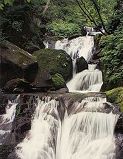
and Aomori Prefectures. The Oirase river
Oirase River
The is a river located in eastern Aomori prefecture, Japan.The Oirase River is the only river draining Lake Towada, a large caldera lake on the border of Aomori and Akita Prefectures. The river flows in a generally eastern direction, through the municipalities of Towada, Rokunohe, Oirase and...
drains Lake Towada; in the summer it is refreshing and in the autumn the leaves are breathtaking.
Mount Osore
Mount Osore
is a region in the center of remote Shimokita Peninsula of Aomori Prefecture, Japan.According to popular mythology, Mount Osore marks the entrance to Hell, with a small brook running to the neighboring Lake Usorisan that is equated to the Sanzu River, a river that deceased souls needed to cross of...
, the Mountain of Dread, is near Mutsu on the Shimokita Peninsula.
The Hakkōda Mountains in Aomori provide excellent hiking in the warmer seasons. However, the winter of 1902 proved disastrous to 199 of 210 soldiers who died during a military maneuver in the area in deep snow.
- Asupamu
- Hakkoda Ship
- Aomori Bay BridgeAomori Bay BridgeThe is a cable-stayed bridge in Aomori. It was constructed in order to alleviate cargo ship traffic. It is a famous part of Aomori City's scenery.-Details:...
- Munakata Shiko Memorial Museum of Art
- Aomori City Forestry Museum
- Aomori Prefectural Folk Museum
- Aomori City History and Folk Arts Museum
- Nebuta-no-sato Museum
- Mount Hakkoda
- Oirase Mountain Stream
- Sannai-Maruyama siteSannai-Maruyama siteis a Jōmon period archaeological site in Sannai, Aomori, Aomori Prefecture, Japan. The site was discovered in 1992, when Aomori Prefecture started surveying a site for a planned baseball stadium. The discovery changed the image of Jōmon-era people.-See also:...
- Shirakami-SanchiShirakami-Sanchiis a UNESCO World Heritage Site in northern Honshū, Japan. This mountainous, unspoiled expanse of virgin forest straddles both Akita and Aomori Prefectures. Of the entire 1,300 km², a tract covering 169.7 km² was included in the list of World Heritage Sites in 1993...
(UNESCO World Heritage Site)
Jesus Christ's grave legend
There is a localized Japanese legend that Jesus Christ did not die on the cross but made his way to Shingō, AomoriShingo, Aomori
is a village located in the Sannohe District of south-central Aomori Prefecture in the Tōhoku region of Japan. As of 2009, the village had an estimated population of 2,830 and a density of 18.8 persons per km². Its total area was 150.85 km²...
where he became a rice farmer, married, and had a family. The legend owes its existence to a supposed 1930s discovery of what were claimed to be "ancient Hebrew documents detailing Jesus' life and death in Japan". The legend also claims that his grave is located in Aomori.
Prefectural symbols
The Aomori prefectural symbol is a stylized map of the prefecture, showing the crown of HonshūHonshu
is the largest island of Japan. The nation's main island, it is south of Hokkaido across the Tsugaru Strait, north of Shikoku across the Inland Sea, and northeast of Kyushu across the Kanmon Strait...
: the Tsugaru
Tsugaru Peninsula
The is a peninsula in Aomori Prefecture, at the northern end of Honshū island, Japan. The peninsula projects north into the Tsugaru Strait separating Honshū from Hokkaidō. The western coast is on the Sea of Japan, while on its eastern coast are Aomori Bay and Mutsu Bay...
, Natsudomari and Shimokita Peninsula
Shimokita Peninsula
The Shimokita Peninsula is the remote northeastern cape of the Japanese island of Honshū, stretching out towards Hokkaidō. Administratively the area is a part of Aomori Prefecture....
s.
Dialects
The two major dialectDialect
The term dialect is used in two distinct ways, even by linguists. One usage refers to a variety of a language that is a characteristic of a particular group of the language's speakers. The term is applied most often to regional speech patterns, but a dialect may also be defined by other factors,...
s of Japanese spoken in Aomori Prefecture are Tsugaru-ben
Tsugaru dialect
The is a Japanese dialect spoken in western Aomori Prefecture.Tsugaru-ben is reputed to be too divergent from standard Japanese for those who are not native speakers, to the point that even people living in the same prefecture may have trouble understanding it. In 1988, fans of the Tsugaru dialect...
(津軽弁) and Nambu-ben (南部弁). The former is prevalent in the area around Hirosaki City
Hirosaki, Aomori
is a city located in southwest Aomori Prefecture, Japan. It is a castle town and was the Tsugaru clan ruled the 100,000 koku tozama han Hirosaki Domain from Hirosaki Castle during the Edo period. The city is currently a regional commercial center and the largest producer of apples in Japan...
, and the latter is heard in and around the city of Hachinohe. There is also the dialect Shimokita-ben (下北弁), which was used in the early Russian–Japanese Dictionary made by a Japanese Russian man whose father came from the Shimokita Peninsula.
TV
- Aomori Broadcasting CorporationAomori Broadcasting CorporationAomori Broadcasting Corporation is a television and radio broadcaster in Aomori, Japan...
(RAB) - Aomori TelevisionAomori Television, also known as ATV, is a Japanese broadcast network affiliated with the JNN. Their headquarters are located in Aomori Prefecture.-History:*1969 December 1 It was set up second broadcasting station of Aomori Prefecture....
(ATV) - Asahi Broadcasting AomoriAsahi Broadcasting Aomori, also known as ABA, is a Japanese broadcast network affiliated with the ANN. It broadcasts to Aomori Prefecture from studio facilities located in Aomori City.220px|thumb|Asahi Broadcasting Aomori-The Headquarters:...
(ABA)