

1964 Niigata earthquake
Encyclopedia
Epicenter
The epicenter or epicentre is the point on the Earth's surface that is directly above the hypocenter or focus, the point where an earthquake or underground explosion originates...
was on the continental shelf
Continental shelf
The continental shelf is the extended perimeter of each continent and associated coastal plain. Much of the shelf was exposed during glacial periods, but is now submerged under relatively shallow seas and gulfs, and was similarly submerged during other interglacial periods. The continental margin,...
off the northwest coast of Honshu
Honshu
is the largest island of Japan. The nation's main island, it is south of Hokkaido across the Tsugaru Strait, north of Shikoku across the Inland Sea, and northeast of Kyushu across the Kanmon Strait...
in Niigata Prefecture
Niigata Prefecture
is a prefecture of Japan located on the island of Honshū on the coast of the Sea of Japan. The capital is the city of Niigata. The name "Niigata" literally means "new lagoon".- History :...
, about 50 km north of the city of Niigata
Niigata, Niigata
is the capital and the most populous city of Niigata Prefecture, Japan. It lies on the northwest coast of Honshu, the largest island of Japan, and faces the Sea of Japan and Sado Island....
. The earthquake
Earthquake
An earthquake is the result of a sudden release of energy in the Earth's crust that creates seismic waves. The seismicity, seismism or seismic activity of an area refers to the frequency, type and size of earthquakes experienced over a period of time...
caused liquefaction
Soil liquefaction
Soil liquefaction describes a phenomenon whereby a saturated soil substantially loses strength and stiffness in response to an applied stress, usually earthquake shaking or other sudden change in stress condition, causing it to behave like a liquid....
over large parts of the city.
Geology
The northwestern side of Honshu lies on the southeastern margin of the Sea of JapanSea of Japan
The Sea of Japan is a marginal sea of the western Pacific Ocean, between the Asian mainland, the Japanese archipelago and Sakhalin. It is bordered by Japan, North Korea, Russia and South Korea. Like the Mediterranean Sea, it has almost no tides due to its nearly complete enclosure from the Pacific...
, an area of oceanic crust
Oceanic crust
Oceanic crust is the part of Earth's lithosphere that surfaces in the ocean basins. Oceanic crust is primarily composed of mafic rocks, or sima, which is rich in iron and magnesium...
created by back-arc spreading from the late Oligocene to middle Miocene
Middle Miocene
The Middle Miocene is a sub-epoch of the Miocene Epoch made up of two stages: the Langhian and Serravallian stages. The Middle Miocene is preceded by the Early Miocene....
. The extensional tectonics
Extensional tectonics
Extensional tectonics is concerned with the structures formed, and the tectonic processes associated with, the stretching of the crust or lithosphere.-Deformation styles:...
associated with the spreading formed a series of N-S trending extensional fault
Extensional fault
An extensional fault is a fault that vertically thins and horizontally extends portions of the Earth's crust and/or lithosphere. In most cases such a fault is also a normal fault, but may be rotated to have a shallower geometry normally associated with a thrust fault...
s and associated basins
Sedimentary basin
The term sedimentary basin is used to refer to any geographical feature exhibiting subsidence and consequent infilling by sedimentation. As the sediments are buried, they are subjected to increasing pressure and begin the process of lithification...
. Currently the area is being deformed by contractional tectonics
Thrust tectonics
Thrust tectonics or contractional tectonics is concerned with the structures formed, and the tectonic processes associated with, the shortening and thickening of the crust or lithosphere.-Deformation styles:...
, causing inversion
Inversion (geology)
In structural geology inversion or basin inversion relates to the relative uplift of a sedimentary basin or similar structure as a result of crustal shortening. This normally excludes uplift developed in the footwalls of later extensional faults, or uplift caused by mantle plumes...
of these earlier basins, forming anticlinal
Anticline
In structural geology, an anticline is a fold that is convex up and has its oldest beds at its core. The term is not to be confused with antiform, which is a purely descriptive term for any fold that is convex up. Therefore if age relationships In structural geology, an anticline is a fold that is...
structures. The earthquake is thought to have occurred due to reverse movement on one of these reactivated faults.
Damage
There were 3,534 houses destroyed and a further 11,000 were damaged. This level of damage is explained by the influence of poor sub-soil conditions. Most of the lower part of the city of Niigata is built on recent deltaicRiver delta
A delta is a landform that is formed at the mouth of a river where that river flows into an ocean, sea, estuary, lake, reservoir, flat arid area, or another river. Deltas are formed from the deposition of the sediment carried by the river as the flow leaves the mouth of the river...
deposits from the Shinano
Shinano River
The Shinano River is the longest and largest river in Japan. It flows from Nagano Prefecture to Niigata Prefecture. It is called the Chikuma River in Nagano Prefecture....
and Agano rivers
Agano River
The Agano River is a river which flows from Fukushima Prefecture to Niigata Prefecture in Japan. It is called the Aga River or the Ōkawa River in Fukushima. It is 210km long with 7,710km² watershed....
, mainly consisting of unconsolidated sand. Shaking during the earthquake caused liquefaction with instantaneous compaction
Soil compaction
In Geotechnical engineering, soil compaction is the process in which a stress applied to a soil causes densification as air is displaced from the pores between the soil grains. When stress is applied that causes densification due to water being displaced from between the soil grains then...
and formation of many sand volcano
Sand volcano
A sand volcano or sand blow is a cone of sand formed by the ejection of sand onto a surface from a central point. The sand builds up as a cone with slopes at the sand's angle of repose. A crater is commonly seen at the summit...
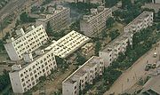
es. Maps of areas of subsidence and sand volcanoes were found to match closely with old maps of the position of former river channels. Subsidence of up to 140 cm was measured over wide areas associated with the liquefaction. In one area of apartment buildings built on reclaimed land by the Shinona River, most of the blocks became inclined, one of them being completely overturned. This was despite relatively low levels of ground acceleration
Peak ground acceleration
Peak ground acceleration is a measure of earthquake acceleration on the ground and an important input parameter for earthquake engineering, also known as the design basis earthquake ground motion...
recorded by strong motion
Strong ground motion
"Peak ground velocity" redirects here.Seismologists usually define strong ground motion as the strong earthquake shaking that occurs close to a causative fault...
accelerograph
Accelerograph
An accelerograph can be referred to as a strong motion seismograph, or simply as an earthquake accelerometer. They are usually constructed as a self-contained box, more commonly now being connected directly to the Internet....
s placed in one of these buildings.
Showa bridge
The collapse of the Showa bridge in Niigata has been analysed in detail. From eyewitness reports it appears that failure began 70 seconds after the start of the earthquake, suggesting that ground motion was not responsible. Movement of pilesDeep foundation
A deep foundation is a type of foundation distinguished from shallow foundations by the depth they are embedded into the ground. There are many reasons a geotechnical engineer would recommend a deep foundation over a shallow foundation, but some of the common reasons are very large design loads, a...
beneath the bridge piers
Pier (architecture)
In architecture, a pier is an upright support for a superstructure, such as an arch or bridge. Sections of wall between openings function as piers. The simplest cross section of the pier is square, or rectangular, although other shapes are also common, such as the richly articulated piers of Donato...
due to lateral spreading caused by liquefaction, is regarded as the main cause of the failure.
Earthquake
The earthquake had a magnitude of 7.6 on the moment magnitude scaleMoment magnitude scale
The moment magnitude scale is used by seismologists to measure the size of earthquakes in terms of the energy released. The magnitude is based on the seismic moment of the earthquake, which is equal to the rigidity of the Earth multiplied by the average amount of slip on the fault and the size of...
, but the relatively deep focal
Hypocenter
The hypocenter refers to the site of an earthquake or a nuclear explosion...
depth of 34 km meant that the perceived intensities on the coast of Honshu were generally VIII (Destructive) or less on the Mercalli intensity scale
Mercalli intensity scale
The Mercalli intensity scale is a seismic scale used for measuring the intensity of an earthquake. It measures the effects of an earthquake, and is distinct from the moment magnitude M_w usually reported for an earthquake , which is a measure of the energy released...
, on consolidated ground. The calculated focal mechanism
Focal mechanism
The focal mechanism of an earthquake describes the inelastic deformation in the source region that generates the seismic waves. In the case of a fault-related event it refers to the orientation of the fault plane that slipped and the slip vector and is also known as a fault-plane solution...
indicates reverse faulting on a west-dipping fault trending N20°E.