
1958 Lituya Bay megatsunami
Encyclopedia
The 1958 Lituya Bay megatsunami
occurred on July 9, 1958, when an earthquake
triggered a landslide that caused 30 million cubic meters of rock and ice to fall into the narrow inlet
of Lituya Bay
, Alaska
. The sudden displacement
of water resulted in a wave hundreds of meters high, that washed over trees and was ultimately measured as washing 524 meters (1,720 feet) up the opposite slope of the inlet, 143 meters (470 feet) taller than the roof of the Empire State Building
. This is the highest recorded megatsunami
and the largest known in modern times. The event forced a re-evaluation of large wave events, and recognition of impact and landslide events as a previously unknown cause of very large waves.
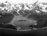
 Lituya Bay is a fjord
located on the Fairweather Fault in the northeastern part of the Gulf of Alaska
. It is a T-shaped bay with a width of two miles (3 km) and a length of seven miles. Lituya Bay is an ice-scoured tidal inlet with a maximum depth of 220 m (722 ft). The narrow entrance of the bay has a depth of only 10 m (33 ft). The two arms that create the top of the T-shape of the bay are the Gilbert and Crillon inlets and are a part of a trench on the Fairweather Fault. In the past 150 years Lituya Bay has had five megatsunamis. The last event, before the 1958 megatsunami, occurred on October 27, 1936. This wave reached a height of 150 m (492 feet), and was caused by another giant landslide from the mountains.
of the quake was at latitude 58.6° N, longitude 137.1° W near the Fairweather Range
, 7.5 miles (12.1 km) east of the surface trace of the Fairweather fault, and 13 miles (20.9 km) southeast of Lituya Bay. This earthquake had been the strongest in over 50 years for this region. (The Cape Yakataga earthquake, with a reading of 8.2 on the Richter scale, occurred on September 4, 1899.) The shock was felt in southeastern Alaska cities over an area of 400000 square miles (1,035,995.2 km²), as far south as Seattle, Washington
, and as far east as Whitehorse, Y.T.
, Canada.
The earthquake caused a subaerial
rock fall in the Gilbert Inlet. This landslide caused 30 million cubic meters of rock to fall into the bay, creating the megatsunami.
After the earthquake there was an observation made on the subglacial lake
, located northwest of the bend in the Lituya Glacier at the head of Lituya Bay. This subglacial lake had dropped 100 ft (30.5 m). So this proposes another possible cause to the production of the giant 1720 ft (524.3 m) wave. It is possible that a good amount of water drained from the glacial lake through a glacial tunnel flowing directly in front of the glacier, though neither the rate of drainage nor the volume of water drained could produce a wave run-off to be 1,720 ft. After all, even if a large enough drainage were to take place in front of the Gilbert Glacier, the run-off would have been projected to be on the opposite side in Crillon inlet. After these considerations glacial drainage was not the mechanism that caused the giant wave.
when the earthquake hit.:
Based on this description, it is possible that the quake had caused the entire glacier (or a large portion of it) to slide over the cliff. What the fisherman may have seen, therefore, could have been that section breaking off and falling into the bay. This might account for the vast displacement of water, while leaving little or no evidence once the ice melted. The height of the wave was accurately measured at 1720 feet (524.3 m), based on the elevation extent of the damage caused to the foliage up the headlands around the area where the landslide occurred as well as along the shoreline of the bay.
Documentary
Megatsunami
Megatsunami is an informal term to describe a tsunami that has initial wave heights that are much larger than normal tsunamis...
occurred on July 9, 1958, when an earthquake
Earthquake
An earthquake is the result of a sudden release of energy in the Earth's crust that creates seismic waves. The seismicity, seismism or seismic activity of an area refers to the frequency, type and size of earthquakes experienced over a period of time...
triggered a landslide that caused 30 million cubic meters of rock and ice to fall into the narrow inlet
Inlet
An inlet is a narrow body of water between islands or leading inland from a larger body of water, often leading to an enclosed body of water, such as a sound, bay, lagoon or marsh. In sea coasts an inlet usually refers to the actual connection between a bay and the ocean and is often called an...
of Lituya Bay
Lituya Bay
Lituya Bay is a fjord located on the coast of the Southeast part of the U.S. state of Alaska. It is long and wide at its widest point. The bay was noted in 1786 by Jean-François de La Pérouse, who named it Port des Français...
, Alaska
Alaska
Alaska is the largest state in the United States by area. It is situated in the northwest extremity of the North American continent, with Canada to the east, the Arctic Ocean to the north, and the Pacific Ocean to the west and south, with Russia further west across the Bering Strait...
. The sudden displacement
Displacement (fluid)
In fluid mechanics, displacement occurs when an object is immersed in a fluid, pushing it out of the way and taking its place. The volume of the fluid displaced can then be measured, as in the illustration, and from this the volume of the immersed object can be deduced .An object that sinks...
of water resulted in a wave hundreds of meters high, that washed over trees and was ultimately measured as washing 524 meters (1,720 feet) up the opposite slope of the inlet, 143 meters (470 feet) taller than the roof of the Empire State Building
Empire State Building
The Empire State Building is a 102-story landmark skyscraper and American cultural icon in New York City at the intersection of Fifth Avenue and West 34th Street. It has a roof height of 1,250 feet , and with its antenna spire included, it stands a total of 1,454 ft high. Its name is derived...
. This is the highest recorded megatsunami
Megatsunami
Megatsunami is an informal term to describe a tsunami that has initial wave heights that are much larger than normal tsunamis...
and the largest known in modern times. The event forced a re-evaluation of large wave events, and recognition of impact and landslide events as a previously unknown cause of very large waves.
Lituya Bay
Fjord
Geologically, a fjord is a long, narrow inlet with steep sides or cliffs, created in a valley carved by glacial activity.-Formation:A fjord is formed when a glacier cuts a U-shaped valley by abrasion of the surrounding bedrock. Glacial melting is accompanied by rebound of Earth's crust as the ice...
located on the Fairweather Fault in the northeastern part of the Gulf of Alaska
Gulf of Alaska
The Gulf of Alaska is an arm of the Pacific Ocean defined by the curve of the southern coast of Alaska, stretching from the Alaska Peninsula and Kodiak Island in the west to the Alexander Archipelago in the east, where Glacier Bay and the Inside Passage are found.The entire shoreline of the Gulf is...
. It is a T-shaped bay with a width of two miles (3 km) and a length of seven miles. Lituya Bay is an ice-scoured tidal inlet with a maximum depth of 220 m (722 ft). The narrow entrance of the bay has a depth of only 10 m (33 ft). The two arms that create the top of the T-shape of the bay are the Gilbert and Crillon inlets and are a part of a trench on the Fairweather Fault. In the past 150 years Lituya Bay has had five megatsunamis. The last event, before the 1958 megatsunami, occurred on October 27, 1936. This wave reached a height of 150 m (492 feet), and was caused by another giant landslide from the mountains.
Geography and geology of Lituya Bay
Near the crest of the Fairweather Mountains sit the Lituya and the North Crillon glaciers. They are each about 12 miles (19.3 km) long and one mile (1.6 km) wide with an elevation of 4000 ft (1,220 m). The retreats of these glaciers form the present T shape of the bay, the Gilbert and Crillon inlets.The 1958 event
The major earthquake that struck on the Fairweather Fault had a Richter scale reading of 7.9, and some sources have reported it to be as much as 8.3. The epicenterEpicenter
The epicenter or epicentre is the point on the Earth's surface that is directly above the hypocenter or focus, the point where an earthquake or underground explosion originates...
of the quake was at latitude 58.6° N, longitude 137.1° W near the Fairweather Range
Fairweather Range
The Fairweather Range is the unofficial name for a mountain range located in the U.S. state of Alaska and the Canadian province of British Columbia. It is the southernmost range of the Saint Elias Mountains...
, 7.5 miles (12.1 km) east of the surface trace of the Fairweather fault, and 13 miles (20.9 km) southeast of Lituya Bay. This earthquake had been the strongest in over 50 years for this region. (The Cape Yakataga earthquake, with a reading of 8.2 on the Richter scale, occurred on September 4, 1899.) The shock was felt in southeastern Alaska cities over an area of 400000 square miles (1,035,995.2 km²), as far south as Seattle, Washington
Seattle, Washington
Seattle is the county seat of King County, Washington. With 608,660 residents as of the 2010 Census, Seattle is the largest city in the Northwestern United States. The Seattle metropolitan area of about 3.4 million inhabitants is the 15th largest metropolitan area in the country...
, and as far east as Whitehorse, Y.T.
Whitehorse, Yukon
Whitehorse is Yukon's capital and largest city . It was incorporated in 1950 and is located at kilometre 1476 on the Alaska Highway in southern Yukon. Whitehorse's downtown and Riverdale areas occupy both shores of the Yukon River, which originates in British Columbia and meets the Bering Sea in...
, Canada.
The earthquake caused a subaerial
Subaerial
The term subaerial is mainly used in geology to describe events or structures that are located at the Earth's surface...
rock fall in the Gilbert Inlet. This landslide caused 30 million cubic meters of rock to fall into the bay, creating the megatsunami.
After the earthquake there was an observation made on the subglacial lake
Subglacial lake
A subglacial lake is a lake under a glacier, typically an ice cap or ice sheet. There are many such lakes, with Lake Vostok in Antarctica being by far the largest known at present.-Characteristics:...
, located northwest of the bend in the Lituya Glacier at the head of Lituya Bay. This subglacial lake had dropped 100 ft (30.5 m). So this proposes another possible cause to the production of the giant 1720 ft (524.3 m) wave. It is possible that a good amount of water drained from the glacial lake through a glacial tunnel flowing directly in front of the glacier, though neither the rate of drainage nor the volume of water drained could produce a wave run-off to be 1,720 ft. After all, even if a large enough drainage were to take place in front of the Gilbert Glacier, the run-off would have been projected to be on the opposite side in Crillon inlet. After these considerations glacial drainage was not the mechanism that caused the giant wave.
Eyewitness account
At 22:15 hours PST on July 9, 1958, which was still daylight at that time of year, an earthquake with a magnitude of 7.9 struck the Lituya Bay area. The tide was ebbing at about plus 1.5 m and the weather was clear. Anchored in Anchorage Cove, near the west side of the entrance of the bay, Bill and Vivian Swanson were on their boat fishingFishing
Fishing is the activity of trying to catch wild fish. Fish are normally caught in the wild. Techniques for catching fish include hand gathering, spearing, netting, angling and trapping....
when the earthquake hit.:
Based on this description, it is possible that the quake had caused the entire glacier (or a large portion of it) to slide over the cliff. What the fisherman may have seen, therefore, could have been that section breaking off and falling into the bay. This might account for the vast displacement of water, while leaving little or no evidence once the ice melted. The height of the wave was accurately measured at 1720 feet (524.3 m), based on the elevation extent of the damage caused to the foliage up the headlands around the area where the landslide occurred as well as along the shoreline of the bay.
See also
- Lituya BayLituya BayLituya Bay is a fjord located on the coast of the Southeast part of the U.S. state of Alaska. It is long and wide at its widest point. The bay was noted in 1786 by Jean-François de La Pérouse, who named it Port des Français...
- Lituya MountainLituya MountainLituya Mountain is a peak in the Fairweather Range of Alaska, United States, south of Mount Fairweather. Its eastern slopes feed a branch of the Johns Hopkins Glacier, which flows into Glacier Bay...
- MegatsunamiMegatsunamiMegatsunami is an informal term to describe a tsunami that has initial wave heights that are much larger than normal tsunamis...
- TsunamiTsunamiA tsunami is a series of water waves caused by the displacement of a large volume of a body of water, typically an ocean or a large lake...
- Historic tsunamisHistoric tsunamisThis article lists notable historic tsunamis, which are sorted by the date and location that the tsunami occurred, the earthquake that generated it, or both....
- Mount CrillonMount CrillonMount Crillon is a high peak of the Fairweather Range, the southernmost part of the Saint Elias Range. It lies southeast of Mount Fairweather, in the promontory between the Gulf of Alaska and Glacier Bay. It is included in Glacier Bay National Park...
Further Information
- Gary Griggs, Our Ocean Backyard: Tsunami rocked Alaska's Lituya Bay in 1958, Santa Cruz Sentinel, April 9, 2011
- Dave Kiffer, Surviving the Biggest Wave Ever 50 Years Ago, 1,700 Foot Wave Devastated Lituya Bay, SitNews, July 8, 2008.
- Howard Ulrich, What It Feels Like...to Survive a Tsunami, Esquire, August 1, 2004.
- Sonny and Howard Ulrich Video retelling of their surviving the event & simulated megatsunami
Documentary
- HorizonHorizonThe horizon is the apparent line that separates earth from sky, the line that divides all visible directions into two categories: those that intersect the Earth's surface, and those that do not. At many locations, the true horizon is obscured by trees, buildings, mountains, etc., and the resulting...
, BBCBBCThe British Broadcasting Corporation is a British public service broadcaster. Its headquarters is at Broadcasting House in the City of Westminster, London. It is the largest broadcaster in the world, with about 23,000 staff...
, first broadcast 12 October 2000. (Mega-tsunami: Wave of Destruction)