

Cubagua
Encyclopedia
Venezuela
Venezuela , officially called the Bolivarian Republic of Venezuela , is a tropical country on the northern coast of South America. It borders Colombia to the west, Guyana to the east, and Brazil to the south...
n state of Nueva Esparta
Nueva Esparta
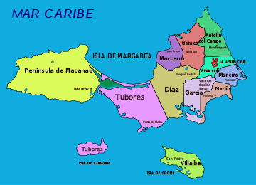
Nueva Esparta State is one of the 23 states of Venezuela. It comprises Margarita Island, Coche, and the largely uninhabited Cubagua.The state is the smallest one in area, and is located off the northeast Caribbean coast of Venezuela. It is the only insular state of Venuezuela...
, after Isla Margarita
Isla Margarita
Margarita Island is the largest island of the state of Nueva Esparta in Venezuela, situated in the Caribbean Sea, off the northeastern coast of the country. The state also contains two other smaller islands: Coche and Cubagua. The capital city of Nueva Esparta is La Asunción, located in a river...
and Coche. It is located 16 km north of Araya Peninsula
Araya Peninsula
The Araya Peninsula is a peninsula located in Venezuela just eastward out from its Caribbean coast, in the state of Sucre. The town of Araya is located on its westernmost extremity. It is the setting of the award-winning documentary film Araya ....
, the closest mainland area.
Topography
The island is 9.2 by 3.6 km in size, an elliptical shape with the longer axis east-west. Its area is 22.438 km². The coast consists of cliffCliff
In geography and geology, a cliff is a significant vertical, or near vertical, rock exposure. Cliffs are formed as erosion landforms due to the processes of erosion and weathering that produce them. Cliffs are common on coasts, in mountainous areas, escarpments and along rivers. Cliffs are usually...
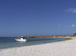
s from five to seven meters high in the south, and from 20 to 24 meters high in the north, but there are also some beach
Beach
A beach is a geological landform along the shoreline of an ocean, sea, lake or river. It usually consists of loose particles which are often composed of rock, such as sand, gravel, shingle, pebbles or cobblestones...
es. The highest elevation of the flat-topped island reaches 32 meters.
Climate
It is dry and lacks surface water bodies (the only freshwater is found in small underground reservoirs). Annual precipitation is 250 mm, which is the value of a dry desertDesert
A desert is a landscape or region that receives an extremely low amount of precipitation, less than enough to support growth of most plants. Most deserts have an average annual precipitation of less than...
. Temperatures are close to 25°C year-round, with little fluctuation.
Vegetation
The desertDesert
A desert is a landscape or region that receives an extremely low amount of precipitation, less than enough to support growth of most plants. Most deserts have an average annual precipitation of less than...
-like (xerophytic
Xerophyte
A xerophyte or xerophytic organism is a plant which has adapted to survive in an environment that lacks water, such as a desert. Xerophytic plants may have adapted shapes and forms or internal functions that reduce their water loss or store water during long periods of dryness...
) vegetation
Vegetation
Vegetation is a general term for the plant life of a region; it refers to the ground cover provided by plants. It is a general term, without specific reference to particular taxa, life forms, structure, spatial extent, or any other specific botanical or geographic characteristics. It is broader...
of the essentially barren island includes a number of cactus
Cactus
A cactus is a member of the plant family Cactaceae. Their distinctive appearance is a result of adaptations to conserve water in dry and/or hot environments. In most species, the stem has evolved to become photosynthetic and succulent, while the leaves have evolved into spines...
species such as Cardón de Dato (Ritterocereus griseus), Buche, Melón de Cerro, Sabana o Monte (Melocactus caesius), Guamacho (Pereskia guamacho), and Opuntia tuna
Opuntia
Opuntia, also known as nopales or paddle cactus , is a genus in the cactus family, Cactaceae.Currently, only prickly pears are included in this genus of about 200 species distributed throughout most of the Americas. Chollas are now separated into the genus Cylindropuntia, which some still consider...
, as well as a few legumes (family Fabaceae
Fabaceae
The Fabaceae or Leguminosae, commonly known as the legume, pea, or bean family, is a large and economically important family of flowering plants. The group is the third largest land plant family, behind only the Orchidaceae and Asteraceae, with 730 genera and over 19,400 species...
) such as Mesquite (Prosopis juliflora
Prosopis juliflora
Prosopis juliflora is a shrub or small tree native to Mexico, South America and the Caribbean. It has become established as a weed in Asia, Australia and elsewhere. Its uses include forage, wood and environmental management. The tree grows to a height of up to and has a trunk with a diameter of...
), Divi-divi
Divi-divi
Caesalpinia coriaria is a leguminous tree or large shrub native to the Caribbean, Mexico, Central America, and northern South America. Common names include Divi-divi, Cascalote, Guaracabuya, Guatapana, Nacascol, and Watapana .- Description :C...
(Caesalpinia coriaria), Poorman’s Friend (Stylosanthes viscosa), and the Sangre Drago (Croton flavens).
Transportation
Cubagua is served by ferries
Ferry
A ferry is a form of transportation, usually a boat, but sometimes a ship, used to carry primarily passengers, and sometimes vehicles and cargo as well, across a body of water. Most ferries operate on regular, frequent, return services...
and other boats from Punta de Piedras
Punta de piedras
Punta de Piedras is a settlement in the Colombian Department of Magdalena. It is located 35km south-west of Pivijay.This settlement is not to be confused with Punta de Piedras in Isla Margarita....
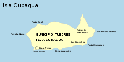
, the capital of Tubores municipality
Municipality
A municipality is essentially an urban administrative division having corporate status and usually powers of self-government. It can also be used to mean the governing body of a municipality. A municipality is a general-purpose administrative subdivision, as opposed to a special-purpose district...
, located eight kilometers to the northeast, on Isla Margarita. The passage takes less than two hours. The boat landing pier
Pier
A pier is a raised structure, including bridge and building supports and walkways, over water, typically supported by widely spread piles or pillars...
is located at the eastern end of Playa Charagato, the main settlement of Cubagua.
There is a lighthouse
Lighthouse
A lighthouse is a tower, building, or other type of structure designed to emit light from a system of lamps and lenses or, in older times, from a fire, and used as an aid to navigation for maritime pilots at sea or on inland waterways....
marking Punta Charagato in the northeast (which the ferry from Isla Margarita passes), and another one at Punta Brasil in the northwest, to aid the ferries from Punta de Piedras to Puerto la Cruz
Puerto la Cruz
Puerto la Cruz is a port city located in Anzoátegui State, in Venezuela. It is the seat of the Juan Antonio Sotillo Municipality. The city has road connections to the state capital, Barcelona, to Lecheria and to Guanta, and has the potential to become the largest and most important metropolitan...
that pass by Cubagua on the west.
History
The first human settlement on Cubagua has been dated to 2325 B.C., a time within the Meso-Indian Period (5000 to 1000 B.C.).Cubagua was discovered for Europeans by Christopher Columbus
Christopher Columbus
Christopher Columbus was an explorer, colonizer, and navigator, born in the Republic of Genoa, in northwestern Italy. Under the auspices of the Catholic Monarchs of Spain, he completed four voyages across the Atlantic Ocean that led to general European awareness of the American continents in the...
in 1498. Its historically most important resources have been the pearl
Pearl
A pearl is a hard object produced within the soft tissue of a living shelled mollusk. Just like the shell of a mollusk, a pearl is made up of calcium carbonate in minute crystalline form, which has been deposited in concentric layers. The ideal pearl is perfectly round and smooth, but many other...
s of pearl oysters, already in pre-European times. The peak of its exploitation occurred from 1508 to 1520. By 1531 signs of resource exhaustion became evident. Between 1530 and 1535 fishing
Fishing
Fishing is the activity of trying to catch wild fish. Fish are normally caught in the wild. Techniques for catching fish include hand gathering, spearing, netting, angling and trapping....
resources were exploited at peak level, to support a growing population.
In 1528, Cristóbal Guerra founded the city of Nueva Cádiz
Nueva Cádiz
Nueva Cádiz is an archaeological site and former port town on Cubagua, off the coast of Venezuela. Established around 1515, it was one of the first settlements in the Americas....
, the first settlement to hold the title of "city" in Venezuela, and one of the first ones in the Americas
Spanish colonization of the Americas
Colonial expansion under the Spanish Empire was initiated by the Spanish conquistadores and developed by the Monarchy of Spain through its administrators and missionaries. The motivations for colonial expansion were trade and the spread of the Christian faith through indigenous conversions...
. The city became a synonym for the suppression by the Hispanic Conquistador
Conquistador
Conquistadors were Spanish soldiers, explorers, and adventurers who brought much of the Americas under the control of Spain in the 15th to 16th centuries, following Europe's discovery of the New World by Christopher Columbus in 1492...
es in South America
South America
South America is a continent situated in the Western Hemisphere, mostly in the Southern Hemisphere, with a relatively small portion in the Northern Hemisphere. The continent is also considered a subcontinent of the Americas. It is bordered on the west by the Pacific Ocean and on the north and east...
. Nueva Cádiz, which reached a population between 1000 and 1500, was destroyed in an earthquake
Earthquake
An earthquake is the result of a sudden release of energy in the Earth's crust that creates seismic waves. The seismicity, seismism or seismic activity of an area refers to the frequency, type and size of earthquakes experienced over a period of time...
followed by a tsunami
Tsunami
A tsunami is a series of water waves caused by the displacement of a large volume of a body of water, typically an ocean or a large lake...
in 1541.
The ruins have been declared a National Monument of Venezuela in 1979.
.jpg)
Administration
Cubagua is part of the municipalityMunicipality
A municipality is essentially an urban administrative division having corporate status and usually powers of self-government. It can also be used to mean the governing body of a municipality. A municipality is a general-purpose administrative subdivision, as opposed to a special-purpose district...
of Tubores, one of eleven municipalities of the state of Nueva Esparta
Nueva Esparta
Nueva Esparta State is one of the 23 states of Venezuela. It comprises Margarita Island, Coche, and the largely uninhabited Cubagua.The state is the smallest one in area, and is located off the northeast Caribbean coast of Venezuela. It is the only insular state of Venuezuela...
.
Population
Human activity dates from the 24th century BC, but the first people did not settle here in a permanent fashion. Instead the island was used as a source of oysters, for food, and for pearls. The lack of vegetation or fresh water made permanent settlement nearly impossible. Today the island still has temporary fisherman, but few to no permanent residents.According to an unofficial census
Census
A census is the procedure of systematically acquiring and recording information about the members of a given population. It is a regularly occurring and official count of a particular population. The term is used mostly in connection with national population and housing censuses; other common...
of population by the Instituto del Patrimonio Cultural in August 2007, the island had a population of 51, of which 19 were children. This population resides in four sub-communities in the northeast of the island, from west to east:
- Playa Falucho
- Playa Charagato (the largest settlement)
- Punta Charagato
- Punta la Cabecera (close to the ruins Nueva Cádiz)
In addition, on some maps a settlement called Punta Arenas appears in the Southwest. Satellite images reveal about five buildings at that site. A small settlement of about four buildings can be made out about midway between Punta La Horca (the westernmost point of Cubagua) and Punta Arenas, south of Punta El Lamparo. Two buildings can be seen on the southern bay of Manglecito, just east of Punta Manglecito.
If the itinerant fishermen from the rest of Nueva Esparta
Nueva Esparta
Nueva Esparta State is one of the 23 states of Venezuela. It comprises Margarita Island, Coche, and the largely uninhabited Cubagua.The state is the smallest one in area, and is located off the northeast Caribbean coast of Venezuela. It is the only insular state of Venuezuela...
from the Venezuelan mainland (State of Sucre
Sucre (state)
Sucre State is one of the 23 states of Venezuela. The state capital is Cumaná. Sucre State covers a total surface area of 11,800 km² and, in 2007, had an estimated population of 916,600.-Municipalities and municipal seats:...
) are included, the population exceeds 300 during the year.